
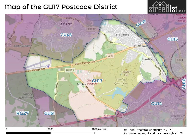
Map of the Postcode District
Explore the postcode district by using our interactive map.
Circles represent recorded crime; the larger the circle, the higher the crime rates.
Your support helps keep this site running!
If you enjoy using this website, consider buying me a coffee to help cover hosting costs.
The postcode district located in the GU Guildford postal area , GU17 has a population of 11,948 residents according to the 2021 England and Wales Census.
The area of the district is 6.32 square miles (16.38 square kilometers or 4,047.39 acres).
Where is the GU17 District?
To give you an idea where the district is located we have created the following table showing nearby towns.
Nearest Towns to GU17
| Town | Distance (miles) | Direction |
|---|---|---|
| Yateley | 1.47 | NNW |
| Sandhurst | 1.84 | N |
| Frimley | 2.99 | E |
| Camberley | 3.09 | ENE |
| Farnborough | 3.09 | SE |
| Fleet | 3.15 | SSW |
| Crowthorne | 3.44 | N |
| Aldershot | 5.25 | SSE |
| Wokingham | 6.33 | N |
| Bracknell | 7.12 | NNE |
| Farnham | 7.28 | S |
| Woodley | 10.16 | NNW |
| Woking | 10.83 | E |
| Guildford | 11.51 | ESE |
| Reading | 11.69 | NW |
| Godalming | 12.55 | SE |
| Basingstoke | 12.67 | WSW |
| Egham | 13.58 | NE |
| Alton | 13.91 | SSW |
The post town for this district is CAMBERLEY.
Postcode Information for District GU17 (Total Geographical Postcodes: 390)
| Location | Post Town | Sector | Number of Postcodes |
|---|---|---|---|
| Blackwater | CAMBERLEY | GU17 9 | 211 |
| Blackwater | CAMBERLEY | GU17 0 | 167 |
| Frogmore | CAMBERLEY | GU17 0 | 12 |
Retail and Shopping in GU17
Street
Town
Locality
Number of Shops
Central Postcode
View on Google Maps
LONDON ROAD
CAMBERLEY
BLACKWATER
35
GU17 9AA
View on Google Maps
BELL LANE
CAMBERLEY
BLACKWATER
8
GU17 0NW
View on Google Maps
| Street | Town | Locality | Number of Shops | Central Postcode | View on Google Maps |
|---|---|---|---|---|---|
| LONDON ROAD | CAMBERLEY | BLACKWATER | 35 | GU17 9AA | View on Google Maps |
| BELL LANE | CAMBERLEY | BLACKWATER | 8 | GU17 0NW | View on Google Maps |
The GU17 postcode district is primarily represented by the settlement of Blackwater, located in the county of Hampshire, England. The significant Postal Town associated with this postcode district is Camberley.
When it comes to local government, postal geography often disregards political borders. However, this district intersects the following councils: the district mostly encompasses the Hart District (281 postal codes), and finally, the Rushmoor District (B) area (19 postal codes).
The GU17 postal code covers the settlement of Blackwater.
The GU17 Postcode shares a border with GU14 (FARNBOROUGH), GU15 (CAMBERLEY, Royal Military Academy), GU46 (YATELEY) and GU47 (SANDHURST, College Town, Owlsmoor).


Schools in the Sector
Frogmore Infant School
Phase: Primary
Address: Green Lane , Frogmore , Camberley
Postcode: GU17 0NY
Headteacher: Mrs Jill King (Headteacher)
Ofsted Rating: Good
Frogmore Junior School
Phase: Primary
Address: Green Lane , Frogmore , Frogmore Junior School , Camberley
Postcode: GU17 0NY
Headteacher: Mrs Emma Rodziewicz (Headteacher)
Ofsted Rating: Good
Hawley Primary School
Phase: Primary
Address: Hawley Road , Blackwater , Camberley
Postcode: GU17 9BH
Headteacher: Miss Jane Baker (Headteacher)
Ofsted Rating: Good
Stations in the Sector
Blackwater
CRS Code: BAW
Operator: GW
Line: North Downs Line
Company: Great Western Railway
Accessable Motorway Junctions
M3 J4
Average Driving Time from within the district: 3.59
Average Driving Distance: 2.17
Number of Postcodes that can access the Motorway Junction: 290
M3 J4A
Average Driving Time from within the district: 5.22
Average Driving Distance: 3.74
Number of Postcodes that can access the Motorway Junction: 290
M3 J3
Average Driving Time from within the district: 7.91
Average Driving Distance: 6.64
Number of Postcodes that can access the Motorway Junction: 289
M3 J5
Average Driving Time from within the district: 12.30
Average Driving Distance: 11.16
Number of Postcodes that can access the Motorway Junction: 290
M4 J11
Average Driving Time from within the district: 15.12
Average Driving Distance: 10.68
Number of Postcodes that can access the Motorway Junction: 1
M4 J10
Average Driving Time from within the district: 15.15
Average Driving Distance: 10.70
Number of Postcodes that can access the Motorway Junction: 290
Weather Forecast for Sandhurst
| Time Period | Icon | Description | Temperature | Rain Probability | Wind |
|---|---|---|---|---|---|
| 12:00 to 15:00 | Light rain shower (day) | 14.0°C (feels like 12.0°C) | 37.00% | SW 11 mph | |
| 15:00 to 18:00 | Partly cloudy (day) | 15.0°C (feels like 14.0°C) | 4.00% | SW 7 mph | |
| 18:00 to 21:00 | Clear night | 12.0°C (feels like 11.0°C) | 1.00% | SW 4 mph | |
| 21:00 to 00:00 | Clear night | 10.0°C (feels like 10.0°C) | 3.00% | SW 4 mph |
| Time Period | Icon | Description | Temperature | Rain Probability | Wind |
|---|---|---|---|---|---|
| 00:00 to 03:00 | Clear night | 9.0°C (feels like 8.0°C) | 3.00% | SSW 2 mph | |
| 03:00 to 06:00 | Clear night | 8.0°C (feels like 8.0°C) | 5.00% | SSE 4 mph | |
| 06:00 to 09:00 | Fog | 9.0°C (feels like 8.0°C) | 16.00% | SSE 4 mph | |
| 09:00 to 12:00 | Fog | 11.0°C (feels like 10.0°C) | 15.00% | SSE 4 mph | |
| 12:00 to 15:00 | Cloudy | 15.0°C (feels like 14.0°C) | 5.00% | S 9 mph | |
| 15:00 to 18:00 | Partly cloudy (day) | 15.0°C (feels like 14.0°C) | 12.00% | S 9 mph | |
| 18:00 to 21:00 | Clear night | 12.0°C (feels like 11.0°C) | 1.00% | SSE 7 mph | |
| 21:00 to 00:00 | Clear night | 10.0°C (feels like 9.0°C) | 0.00% | SE 7 mph |
| Time Period | Icon | Description | Temperature | Rain Probability | Wind |
|---|---|---|---|---|---|
| 00:00 to 03:00 | Clear night | 11.0°C (feels like 9.0°C) | 0.00% | SE 9 mph | |
| 03:00 to 06:00 | Clear night | 10.0°C (feels like 9.0°C) | 1.00% | SE 9 mph | |
| 06:00 to 09:00 | Clear night | 10.0°C (feels like 8.0°C) | 1.00% | SSE 9 mph | |
| 09:00 to 12:00 | Cloudy | 13.0°C (feels like 11.0°C) | 5.00% | SSE 11 mph | |
| 12:00 to 15:00 | Cloudy | 15.0°C (feels like 13.0°C) | 6.00% | S 13 mph | |
| 15:00 to 18:00 | Cloudy | 15.0°C (feels like 13.0°C) | 6.00% | S 13 mph | |
| 18:00 to 21:00 | Partly cloudy (night) | 14.0°C (feels like 12.0°C) | 6.00% | SSE 11 mph | |
| 21:00 to 00:00 | Cloudy | 15.0°C (feels like 13.0°C) | 16.00% | S 13 mph |
| Time Period | Icon | Description | Temperature | Rain Probability | Wind |
|---|---|---|---|---|---|
| 00:00 to 03:00 | Light rain shower (night) | 14.0°C (feels like 12.0°C) | 42.00% | SSW 13 mph | |
| 03:00 to 06:00 | Light rain shower (night) | 12.0°C (feels like 11.0°C) | 37.00% | SSW 9 mph | |
| 06:00 to 09:00 | Light rain shower (night) | 11.0°C (feels like 10.0°C) | 29.00% | SSW 9 mph | |
| 09:00 to 12:00 | Sunny day | 12.0°C (feels like 10.0°C) | 5.00% | SSW 11 mph | |
| 12:00 to 15:00 | Partly cloudy (day) | 13.0°C (feels like 11.0°C) | 10.00% | SW 13 mph | |
| 15:00 to 18:00 | Partly cloudy (day) | 13.0°C (feels like 10.0°C) | 11.00% | SW 11 mph | |
| 18:00 to 21:00 | Clear night | 10.0°C (feels like 8.0°C) | 3.00% | SW 11 mph | |
| 21:00 to 00:00 | Clear night | 9.0°C (feels like 6.0°C) | 1.00% | SW 9 mph |
| Time Period | Icon | Description | Temperature | Rain Probability | Wind |
|---|---|---|---|---|---|
| 00:00 to 03:00 | Clear night | 8.0°C (feels like 6.0°C) | 1.00% | SW 9 mph | |
| 03:00 to 06:00 | Clear night | 8.0°C (feels like 6.0°C) | 2.00% | SW 9 mph | |
| 06:00 to 09:00 | Partly cloudy (night) | 8.0°C (feels like 6.0°C) | 2.00% | SW 9 mph | |
| 09:00 to 12:00 | Sunny day | 10.0°C (feels like 8.0°C) | 8.00% | SW 11 mph | |
| 12:00 to 15:00 | Cloudy | 13.0°C (feels like 10.0°C) | 12.00% | SW 13 mph | |
| 15:00 to 18:00 | Cloudy | 13.0°C (feels like 11.0°C) | 14.00% | SW 11 mph | |
| 18:00 to 21:00 | Clear night | 11.0°C (feels like 9.0°C) | 7.00% | SW 11 mph | |
| 21:00 to 00:00 | Clear night | 11.0°C (feels like 9.0°C) | 6.00% | SW 9 mph |
| Postal Sector | Delivery Office |
|---|---|
| GU17 0 | Camberley Delivery Office |
| GU17 9 | Camberley Delivery Office |
| GU17 9 | Sandhurst (gu) Delivery Office |
| G | U | 1 | 7 | - | X | X | X |
| G | U | 1 | 7 | Space | Numeric | Letter | Letter |
Street List for the GU17 District
Current Monthly Rental Prices
| # Bedrooms | Min Price | Max Price | Avg Price |
|---|---|---|---|
| 1 | £550 | £550 | £550 |
| 3 | £2,000 | £2,000 | £2,000 |
| 4 | £3,000 | £3,000 | £3,000 |
Current House Prices
| # Bedrooms | Min Price | Max Price | Avg Price |
|---|---|---|---|
| £1,500,000 | £1,500,000 | £1,500,000 | |
| 1 | £80,000 | £230,000 | £130,800 |
| 2 | £156,250 | £400,000 | £275,893 |
| 3 | £310,000 | £750,000 | £463,802 |
| 4 | £425,000 | £1,350,000 | £595,945 |
| 5 | £500,000 | £880,000 | £655,990 |
| 6 | £5,750,000 | £5,750,000 | £5,750,000 |
| 9 | £5,750,000 | £5,750,000 | £5,750,000 |
Estate Agents
| Logo | Name | Brand Name | Address | Contact Number |
|---|---|---|---|---|
 | Blackwater | Seymours Estate Agents | 6 Kings Parade, 34 London Road, Blackwater, Camberley, GU17 9AA | 01276 740116 |
 | Fernhurst | Crest Nicholson | Hawley Road, Blackwater, GU17 9EF | 01276 740122 |
 | Yateley | Romans | 62-64 Reading Road, Yateley, Hampshire, GU46 7UH | 01252 221975 |
 | Yateley | Mackenzie Smith | 31 Plough Road, Yateley, GU46 7UW | 01252 221899 |
 | Frimley | Bridges Estate Agents | 90 High Street, Frimley, Surrey, GU16 7JE | 01276 740107 |
Yearly House Price Averages for the District
| Type of Property | 2018 Average | 2018 Sales | 2017 Average | 2017 Sales | 2016 Average | 2016 Sales | 2015 Average | 2015 Sales |
|---|---|---|---|---|---|---|---|---|
| Detached | £516,726 | 44 | £502,713 | 42 | £516,761 | 41 | £549,701 | 74 |
| Semi-Detached | £370,737 | 41 | £359,978 | 37 | £350,849 | 35 | £327,514 | 36 |
| Terraced | £308,558 | 43 | £305,630 | 60 | £300,243 | 67 | £276,989 | 77 |
| Flats | £198,913 | 16 | £199,498 | 21 | £195,682 | 22 | £184,191 | 35 |