The GU6 postcode district is a postal district located in the GU Guildford postcode area with a population of 15,895 residents according to the 2021 England and Wales Census.
The area of the GU6 postcode district is 23.59 square miles which is 61.11 square kilometres or 15,100.52 acres.
Currently, the GU6 district has about 534 postcode units spread across 2 geographic postcode sectors.
Given that each sector allows for 400 unique postcode combinations, the district has a capacity of 800 postcodes. With 534 postcodes already in use, this leaves 266 units available.
The largest settlement in the GU6 postal code is CRANLEIGH followed by Ewhurst, and Alfold.
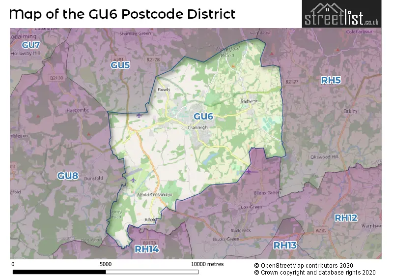
The GU6 Postcode shares a border with GU8 (Milford, Chiddingfold, Elstead), RH14 (BILLINGSHURST, Loxwood, Wisborough Green), GU5 (Bramley, Shamley Green, Albury), RH12 (HORSHAM, Broadbridge Heath, Faygate) and RH5 (Newdigate, Beare Green, North Holmwood).
The primary settlement in the GU6 postcode district is Cranleigh, which is located in Surrey, England. Other significant settlements in the district include Ewhurst and Alfold. The postal town for the area is Cranleigh.
For the district GU6, we have data on 3 postcode sectors. Here's a breakdown: The sector GU6 7, covers Cranleigh and Ewhurst in Surrey. The sector GU6 8, covers Cranleigh and Alfold in Surrey. The sector GU6 9 is non-geographic. It's often designated for PO Boxes, large organisations, or special services.

Map of the GU6 Postcode District
Explore the GU6 postcode district by using our free interactive map.
When it comes to local government, postal geography often disregards political borders. However, for a breakdown in the GU6 District: the district mostly encompasses the Waverley District (B) area with a total of 551 postcodes.
Recent House Sales in GU6
| Date | Price | Address |
|---|---|---|
| 18/10/2023 | £663,160 | The Common, Cranleigh, GU6 8NS |
| 29/09/2023 | £900,000 | Mead Close, Cranleigh, GU6 7BH |
| 29/09/2023 | £185,000 | Elm Park, Cranleigh, GU6 8UG |
| 22/09/2023 | £640,000 | Heron Shaw, Cranleigh, GU6 8BT |
| 06/09/2023 | £1,460,000 | Newlands, Cranleigh, GU6 8GJ |
| 01/09/2023 | £348,000 | Elmbridge Road, Cranleigh, GU6 8NP |
| 31/08/2023 | £525,000 | Elmbridge Road, Cranleigh, GU6 8NP |
| 30/08/2023 | £695,000 | Bookhurst Road, Cranleigh, GU6 7DW |
| 30/08/2023 | £1,047,000 | Gibbet Mead, Cranleigh, GU6 8GF |
| 30/08/2023 | £805,000 | Worcester Drive, Cranleigh, GU6 7FW |
Where is the GU6 Postcode District?
The GU6 postcode district is located in the town of Cranleigh. Cranleigh is situated near several nearby towns. To the north-west is Godalming, which is approximately 6.09 miles away. Going south, one will find Billingshurst, which is about 7.82 miles from Cranleigh. To the north-east is Dorking, which is approximately 8.35 miles away. Horsham is located to the south-east and is about 8.64 miles from Cranleigh. Heading north, one will find West Horsley, which is approximately 10.34 miles away. Finally, Haslemere is located to the south-west, around 10.40 miles from Cranleigh. Furthermore, Cranleigh is approximately 29.84 miles away from the center of London.
The district is within the post town of CRANLEIGH.
The sector has postcodes within the nation of England.
The GU6 Postcode District is in the West Surrey region of Surrey, East and West Sussex within the South East (England).
Weather Forecast for GU6
Press Button to Show Forecast for Cranleigh
| Time Period | Icon | Description | Temperature | Rain Probability | Wind |
|---|---|---|---|---|---|
| 12:00 to 15:00 | Cloudy | 14.0°C (feels like 12.0°C) | 16.00% | SSE 11 mph | |
| 15:00 to 18:00 | Cloudy | 16.0°C (feels like 14.0°C) | 11.00% | SSE 11 mph | |
| 18:00 to 21:00 | Cloudy | 15.0°C (feels like 13.0°C) | 5.00% | SE 11 mph | |
| 21:00 to 00:00 | Cloudy | 14.0°C (feels like 12.0°C) | 7.00% | ESE 9 mph |
Press Button to Show Forecast for Cranleigh
| Time Period | Icon | Description | Temperature | Rain Probability | Wind |
|---|---|---|---|---|---|
| 00:00 to 03:00 | Cloudy | 13.0°C (feels like 12.0°C) | 7.00% | SE 9 mph | |
| 03:00 to 06:00 | Cloudy | 12.0°C (feels like 11.0°C) | 7.00% | SE 7 mph | |
| 06:00 to 09:00 | Cloudy | 13.0°C (feels like 12.0°C) | 6.00% | SE 7 mph | |
| 09:00 to 12:00 | Cloudy | 15.0°C (feels like 14.0°C) | 7.00% | SSE 9 mph | |
| 12:00 to 15:00 | Cloudy | 17.0°C (feels like 15.0°C) | 8.00% | SSE 9 mph | |
| 15:00 to 18:00 | Cloudy | 17.0°C (feels like 15.0°C) | 7.00% | SSE 7 mph | |
| 18:00 to 21:00 | Partly cloudy (day) | 16.0°C (feels like 15.0°C) | 6.00% | SSE 4 mph | |
| 21:00 to 00:00 | Partly cloudy (night) | 12.0°C (feels like 11.0°C) | 4.00% | SE 4 mph |
Press Button to Show Forecast for Cranleigh
| Time Period | Icon | Description | Temperature | Rain Probability | Wind |
|---|---|---|---|---|---|
| 00:00 to 03:00 | Clear night | 11.0°C (feels like 10.0°C) | 1.00% | SE 4 mph | |
| 03:00 to 06:00 | Cloudy | 9.0°C (feels like 9.0°C) | 5.00% | SE 4 mph | |
| 06:00 to 09:00 | Cloudy | 11.0°C (feels like 11.0°C) | 8.00% | SE 2 mph | |
| 09:00 to 12:00 | Cloudy | 16.0°C (feels like 15.0°C) | 8.00% | S 4 mph | |
| 12:00 to 15:00 | Cloudy | 18.0°C (feels like 17.0°C) | 11.00% | SSW 7 mph | |
| 15:00 to 18:00 | Cloudy | 17.0°C (feels like 16.0°C) | 10.00% | SSW 7 mph | |
| 18:00 to 21:00 | Cloudy | 16.0°C (feels like 15.0°C) | 9.00% | SW 4 mph | |
| 21:00 to 00:00 | Cloudy | 12.0°C (feels like 12.0°C) | 7.00% | SW 4 mph |
Press Button to Show Forecast for Cranleigh
| Time Period | Icon | Description | Temperature | Rain Probability | Wind |
|---|---|---|---|---|---|
| 00:00 to 03:00 | Partly cloudy (night) | 11.0°C (feels like 10.0°C) | 6.00% | WSW 4 mph | |
| 03:00 to 06:00 | Cloudy | 10.0°C (feels like 9.0°C) | 5.00% | WSW 4 mph | |
| 06:00 to 09:00 | Partly cloudy (day) | 12.0°C (feels like 11.0°C) | 5.00% | WSW 4 mph | |
| 09:00 to 12:00 | Cloudy | 16.0°C (feels like 15.0°C) | 13.00% | WSW 7 mph | |
| 12:00 to 15:00 | Light rain shower (day) | 18.0°C (feels like 17.0°C) | 39.00% | WSW 7 mph | |
| 15:00 to 18:00 | Light rain shower (day) | 18.0°C (feels like 17.0°C) | 40.00% | WSW 7 mph | |
| 18:00 to 21:00 | Light rain shower (day) | 17.0°C (feels like 16.0°C) | 36.00% | WSW 7 mph | |
| 21:00 to 00:00 | Partly cloudy (night) | 13.0°C (feels like 12.0°C) | 4.00% | WSW 4 mph |
Press Button to Show Forecast for Cranleigh
| Time Period | Icon | Description | Temperature | Rain Probability | Wind |
|---|---|---|---|---|---|
| 00:00 to 03:00 | Partly cloudy (night) | 12.0°C (feels like 11.0°C) | 4.00% | W 4 mph | |
| 03:00 to 06:00 | Cloudy | 11.0°C (feels like 10.0°C) | 10.00% | WNW 4 mph | |
| 06:00 to 09:00 | Cloudy | 12.0°C (feels like 12.0°C) | 11.00% | WNW 4 mph | |
| 09:00 to 12:00 | Cloudy | 15.0°C (feels like 15.0°C) | 10.00% | NW 7 mph | |
| 12:00 to 15:00 | Light rain shower (day) | 17.0°C (feels like 16.0°C) | 31.00% | NW 7 mph | |
| 15:00 to 18:00 | Light rain shower (day) | 18.0°C (feels like 17.0°C) | 33.00% | NW 7 mph | |
| 18:00 to 21:00 | Light rain shower (day) | 17.0°C (feels like 16.0°C) | 31.00% | NW 7 mph | |
| 21:00 to 00:00 | Clear night | 13.0°C (feels like 13.0°C) | 3.00% | NW 7 mph |
| Postcode Sector | Delivery Office |
|---|---|
| GU6 7 | Cranleigh Delivery Office |
| GU6 8 | Cranleigh Delivery Office |
| GU6 9 | Cranleigh Delivery Office |
| G | U | 6 | - | X | X | X |
| G | U | 6 | Space | Numeric | Letter | Letter |
Current Monthly Rental Prices
| # Bedrooms | Min Price | Max Price | Avg Price |
|---|---|---|---|
| £950 | £1,150 | £1,050 | |
| 1 | £900 | £1,350 | £1,150 |
| 2 | £1,150 | £3,900 | £1,920 |
| 3 | £1,450 | £3,500 | £2,007 |
| 4 | £2,950 | £3,250 | £3,067 |
Current House Prices
| # Bedrooms | Min Price | Max Price | Avg Price |
|---|---|---|---|
| £500,000 | £4,000,000 | £2,250,000 | |
| 1 | £120,000 | £395,000 | £235,556 |
| 2 | £99,500 | £750,000 | £395,128 |
| 3 | £212,000 | £2,000,000 | £637,519 |
| 4 | £395,000 | £2,000,000 | £909,583 |
| 5 | £800,000 | £2,000,000 | £1,474,667 |
Estate Agents who Operate in the GU6 District
| Logo | Name | Brand Name | Address | Contact Number | Total Properties |
|---|---|---|---|---|---|
 | Cranleigh | Roger Coupe | 3 Bank Buildings, High Street, Cranleigh, GU6 8BB | 01483 968579 | 48 |
 | Cranleigh | Cubitt & West | Lee House, High Street, Cranleigh, Surrey, GU6 8AQ | 01483 694588 | 21 |
 | Cranleigh | Burns & Webber | Cranleigh House, 32 High Street, Cranleigh, GU6 8AE | 01483 967942 | 17 |
 | Cranleigh | Christian Reid | 1 Bank Buildings, 145 High Street, Cranleigh, Surrey, GU6 8BB | 01483 273525 | 17 |
 | Cranleigh | Chantries and Pewleys Estate Agents | Britannia House, 133 High Street, Cranleigh, GU6 8AU | 01483 967239 | 12 |
Yearly House Price Averages for the GU6 Postcode District
| Type of Property | 2018 Average | 2018 Sales | 2017 Average | 2017 Sales | 2016 Average | 2016 Sales | 2015 Average | 2015 Sales |
|---|---|---|---|---|---|---|---|---|
| Detached | £720,822 | 124 | £759,824 | 99 | £730,484 | 85 | £702,221 | 108 |
| Semi-Detached | £466,151 | 54 | £462,096 | 62 | £434,247 | 47 | £391,275 | 52 |
| Terraced | £301,283 | 23 | £373,084 | 38 | £340,734 | 41 | £300,905 | 37 |
| Flats | £304,042 | 42 | £258,374 | 60 | £289,295 | 48 | £213,602 | 43 |