The RH14 postcode district is a postal district located in the RH Redhill postcode area with a population of 16,936 residents according to the 2021 England and Wales Census.
The area of the RH14 postcode district is 44.57 square miles which is 115.43 square kilometres or 28,524.06 acres.
Currently, the RH14 district has about 584 postcode units spread across 2 geographic postcode sectors.
Given that each sector allows for 400 unique postcode combinations, the district has a capacity of 800 postcodes. With 584 postcodes already in use, this leaves 216 units available.
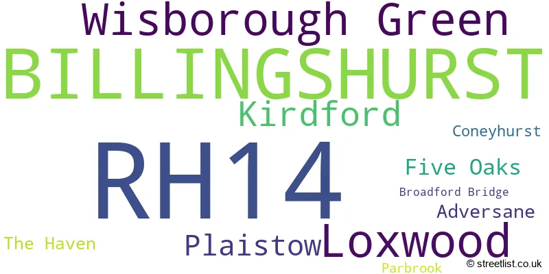
The largest settlement in the RH14 postal code is BILLINGSHURST followed by Loxwood, and Wisborough Green.
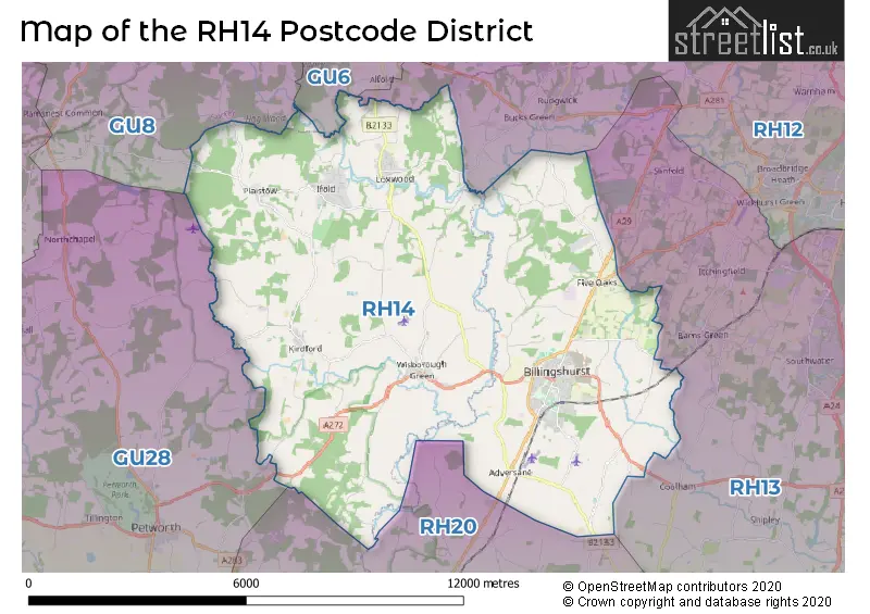
The RH14 Postcode shares a border with RH13 (HORSHAM, Southwater, Partridge Green), GU28 (PETWORTH, Northchapel, Graffham), GU6 (CRANLEIGH, Ewhurst, Alfold), GU8 (Milford, Chiddingfold, Elstead), RH20 (Storrington, PULBOROUGH, West Chiltington) and RH12 (HORSHAM, Broadbridge Heath, Faygate).
In the RH14 postcode district in West Sussex, the primary settlement is Billinghurst. Other significant settlements include Kirdford, Loxwood, Plaistow, and Wisborough Green. The most significant post town in this district is also Billinghurst, located in the county of West Sussex in England.
For the district RH14, we have data on 3 postcode sectors. Here's a breakdown: The sector RH14 0, covers Loxwood and Wisborough Green and Kirdford and Plaistow in West Sussex. The sector RH14 4 is non-geographic. It's often designated for PO Boxes, large organisations, or special services. The sector RH14 9, covers Billingshurst in West Sussex.

Map of the RH14 Postcode District
Explore the RH14 postcode district by using our free interactive map.
When it comes to local government, postal geography often disregards political borders. However, for a breakdown in the RH14 District: the district mostly encompasses the Horsham District (334 postcodes), and finally, the Chichester District area (255 postcodes).
Recent House Sales in RH14
| Date | Price | Address |
|---|---|---|
| 27/09/2023 | £325,000 | Saville Gardens, Billingshurst, RH14 9RR |
| 15/09/2023 | £395,000 | Honeysuckle Drive, Billingshurst, RH14 9UL |
| 15/09/2023 | £515,000 | Nightingale Walk, Billingshurst, RH14 9TY |
| 31/08/2023 | £225,000 | Brookers Road, Billingshurst, RH14 9GH |
| 29/08/2023 | £430,000 | Coombe Hill, Billingshurst, RH14 9LA |
| 25/08/2023 | £400,000 | Carpenters, Billingshurst, RH14 9RB |
| 25/08/2023 | £650,000 | West Street, Billingshurst, RH14 9LG |
| 24/08/2023 | £715,000 | Cranham Avenue, Billingshurst, RH14 9EN |
| 24/08/2023 | £505,000 | Golden Cross Cottages, Plaistow, Billingshurst, RH14 0PY |
| 18/08/2023 | £1,825,000 | Newpound, Wisborough Green, Billingshurst, RH14 0AT |
Weather Forecast for RH14
Press Button to Show Forecast for Wisborough Green
| Time Period | Icon | Description | Temperature | Rain Probability | Wind |
|---|---|---|---|---|---|
| 12:00 to 15:00 | Overcast | 8.0°C (feels like 6.0°C) | 10.00% | E 9 mph | |
| 15:00 to 18:00 | Overcast | 9.0°C (feels like 7.0°C) | 10.00% | ESE 9 mph | |
| 18:00 to 21:00 | Cloudy | 9.0°C (feels like 7.0°C) | 11.00% | ESE 7 mph | |
| 21:00 to 00:00 | Light rain | 7.0°C (feels like 6.0°C) | 76.00% | ENE 7 mph |
Press Button to Show Forecast for Wisborough Green
| Time Period | Icon | Description | Temperature | Rain Probability | Wind |
|---|---|---|---|---|---|
| 00:00 to 03:00 | Heavy rain | 7.0°C (feels like 5.0°C) | 82.00% | ENE 7 mph | |
| 03:00 to 06:00 | Light rain | 7.0°C (feels like 4.0°C) | 56.00% | NE 9 mph | |
| 06:00 to 09:00 | Light rain | 7.0°C (feels like 5.0°C) | 46.00% | NE 9 mph | |
| 09:00 to 12:00 | Overcast | 10.0°C (feels like 8.0°C) | 33.00% | ENE 9 mph | |
| 12:00 to 15:00 | Light rain | 12.0°C (feels like 11.0°C) | 49.00% | ENE 7 mph | |
| 15:00 to 18:00 | Cloudy | 12.0°C (feels like 11.0°C) | 20.00% | NE 9 mph | |
| 18:00 to 21:00 | Heavy rain | 11.0°C (feels like 9.0°C) | 85.00% | NE 9 mph | |
| 21:00 to 00:00 | Heavy rain | 10.0°C (feels like 7.0°C) | 87.00% | NE 9 mph |
Press Button to Show Forecast for Wisborough Green
| Time Period | Icon | Description | Temperature | Rain Probability | Wind |
|---|---|---|---|---|---|
| 00:00 to 03:00 | Heavy rain | 9.0°C (feels like 7.0°C) | 87.00% | NE 9 mph | |
| 03:00 to 06:00 | Heavy rain | 9.0°C (feels like 8.0°C) | 93.00% | NE 7 mph | |
| 06:00 to 09:00 | Heavy rain | 9.0°C (feels like 7.0°C) | 88.00% | N 7 mph | |
| 09:00 to 12:00 | Heavy rain | 9.0°C (feels like 6.0°C) | 86.00% | NW 11 mph | |
| 12:00 to 15:00 | Overcast | 10.0°C (feels like 7.0°C) | 22.00% | WNW 13 mph | |
| 15:00 to 18:00 | Cloudy | 11.0°C (feels like 9.0°C) | 12.00% | WNW 11 mph | |
| 18:00 to 21:00 | Partly cloudy (day) | 10.0°C (feels like 9.0°C) | 9.00% | W 7 mph | |
| 21:00 to 00:00 | Clear night | 8.0°C (feels like 6.0°C) | 2.00% | SW 4 mph |
Press Button to Show Forecast for Wisborough Green
| Time Period | Icon | Description | Temperature | Rain Probability | Wind |
|---|---|---|---|---|---|
| 00:00 to 03:00 | Clear night | 6.0°C (feels like 5.0°C) | 1.00% | SW 4 mph | |
| 03:00 to 06:00 | Clear night | 5.0°C (feels like 3.0°C) | 4.00% | S 4 mph | |
| 06:00 to 09:00 | Sunny day | 7.0°C (feels like 6.0°C) | 1.00% | SSE 4 mph | |
| 09:00 to 12:00 | Partly cloudy (day) | 12.0°C (feels like 10.0°C) | 3.00% | S 9 mph | |
| 12:00 to 15:00 | Partly cloudy (day) | 14.0°C (feels like 11.0°C) | 3.00% | S 11 mph | |
| 15:00 to 18:00 | Partly cloudy (day) | 14.0°C (feels like 11.0°C) | 3.00% | S 11 mph | |
| 18:00 to 21:00 | Sunny day | 12.0°C (feels like 11.0°C) | 1.00% | S 7 mph | |
| 21:00 to 00:00 | Clear night | 8.0°C (feels like 6.0°C) | 1.00% | SE 4 mph |
Press Button to Show Forecast for Wisborough Green
| Time Period | Icon | Description | Temperature | Rain Probability | Wind |
|---|---|---|---|---|---|
| 00:00 to 03:00 | Clear night | 8.0°C (feels like 6.0°C) | 2.00% | ESE 7 mph | |
| 03:00 to 06:00 | Clear night | 8.0°C (feels like 6.0°C) | 3.00% | ESE 7 mph | |
| 06:00 to 09:00 | Sunny day | 9.0°C (feels like 8.0°C) | 4.00% | ESE 7 mph | |
| 09:00 to 12:00 | Partly cloudy (day) | 14.0°C (feels like 12.0°C) | 4.00% | SE 9 mph | |
| 12:00 to 15:00 | Cloudy | 16.0°C (feels like 14.0°C) | 9.00% | SE 11 mph | |
| 15:00 to 18:00 | Partly cloudy (day) | 16.0°C (feels like 14.0°C) | 5.00% | SE 9 mph | |
| 18:00 to 21:00 | Cloudy | 14.0°C (feels like 13.0°C) | 9.00% | SE 7 mph | |
| 21:00 to 00:00 | Partly cloudy (night) | 11.0°C (feels like 10.0°C) | 7.00% | ESE 7 mph |
Where is the RH14 Postcode District?
The RH14 postcode district is located in the town of Billingshurst. It is situated near several nearby towns, including Pulborough to the South, Petworth to the South West, Cranleigh to the North, Horsham to the East, Haslemere to the West, Godalming to the North West, and Steyning to the South East. The district is approximately 36.31 miles away from the center of London.
The district is within the post town of BILLINGSHURST.
The sector has postcodes within the nation of England.
The RH14 Postcode District is covers the following regions.
- West Sussex (South West) - Surrey, East and West Sussex - South East (England)
- West Sussex (North East) - Surrey, East and West Sussex - South East (England)
| Postcode Sector | Delivery Office |
|---|---|
| RH14 0 | Billingshurst Delivery Office |
| RH14 9 | Billingshurst Delivery Office |
| R | H | 1 | 4 | - | X | X | X |
| R | H | 1 | 4 | Space | Numeric | Letter | Letter |
Tourist Attractions within the Postcode Area
We found 1 visitor attractions within the RH14 postcode area
| Fishers Adventure Farm Park |
|---|
| Leisure / Theme Parks |
| Leisure / Theme Park |
| View Fishers Adventure Farm Park on Google Maps |
Current Monthly Rental Prices
| # Bedrooms | Min Price | Max Price | Avg Price |
|---|---|---|---|
| 1 | £1,000 | £1,000 | £1,000 |
| 2 | £1,300 | £1,300 | £1,300 |
| 4 | £3,000 | £3,000 | £3,000 |
Current House Prices
| # Bedrooms | Min Price | Max Price | Avg Price |
|---|---|---|---|
| £60,000 | £1,500,000 | £581,667 | |
| 1 | £85,000 | £200,000 | £140,470 |
| 2 | £175,000 | £700,000 | £332,820 |
| 3 | £350,000 | £1,750,000 | £627,500 |
| 4 | £450,000 | £1,599,500 | £833,776 |
| 5 | £550,000 | £4,500,000 | £1,382,105 |
| 6 | £1,575,000 | £4,650,000 | £2,650,000 |
| 7 | £2,000,000 | £3,000,000 | £2,333,333 |
| 8 | £1,450,000 | £1,450,000 | £1,450,000 |
| 9 | £4,650,000 | £4,950,000 | £4,800,000 |
Estate Agents who Operate in the RH14 District
| Logo | Name | Brand Name | Address | Contact Number | Total Properties |
|---|---|---|---|---|---|
 | Billingshurst | Henry Adams | 35 High Street, Billingshurst, RH14 9PP | 01403 912656 | 20 |
 | Billingshurst | Mansell McTaggart | 70 High Street, Billingshurst, RH14 9QS | 01403 912666 | 18 |
 | Billingshurst | Fowlers | 74 High Street, Billingshurst, RH14 9QS | 01403 912627 | 17 |
 | Wisborough Green | Penfolds | Upfields Stores School Road Wisborough Green, RH14 0DT | 01403 912674 | 9 |
 | Billingshurst | Alex Harvey Estate Agents, Powered by Keller Williams | 64 High Street, Off Mill Way, Billingshurst RH14 9NY | 01403 784110 | 8 |
| Type of Property | 2018 Average | 2018 Sales | 2017 Average | 2017 Sales | 2016 Average | 2016 Sales | 2015 Average | 2015 Sales |
|---|---|---|---|---|---|---|---|---|
| Detached | £649,843 | 130 | £659,568 | 118 | £552,959 | 130 | £544,650 | 134 |
| Semi-Detached | £398,089 | 77 | £377,054 | 53 | £361,641 | 94 | £344,893 | 82 |
| Terraced | £340,887 | 54 | £324,025 | 38 | £303,736 | 48 | £266,647 | 60 |
| Flats | £232,533 | 30 | £189,924 | 29 | £185,635 | 33 | £157,788 | 41 |