This section of the site is all about the PO Postcode area, also known as the Portsmouth Postal Area. Explore links to the next level to learn more about specific postcode districts such as PO1.
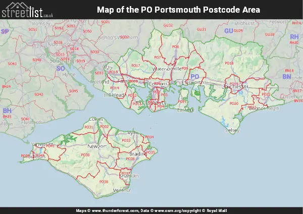
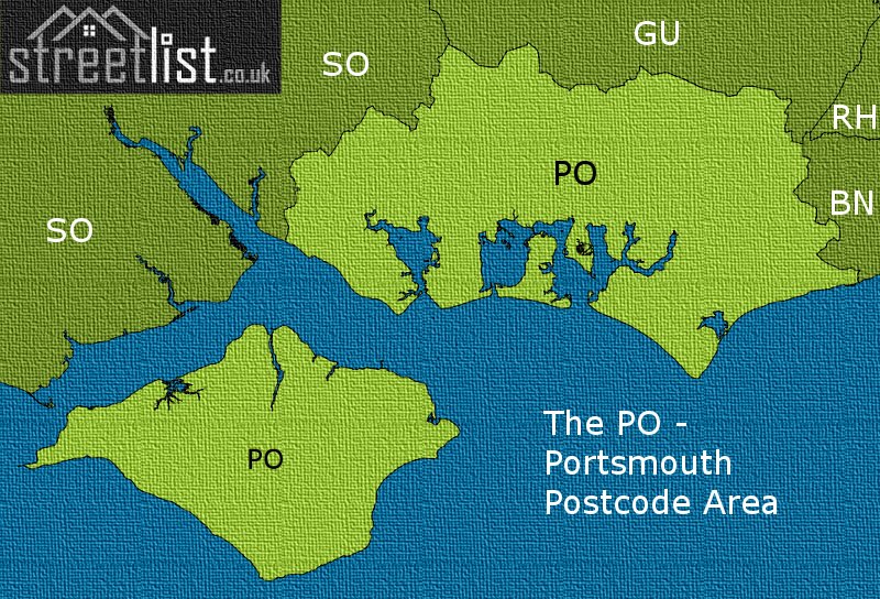
Map of the PO Postcode Area
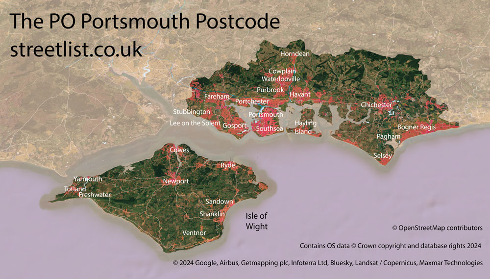
The PO postcode area represents a group of postal districts in the Portsmouth area of the United Kingdom. The area code PO stands for the letters p and o in POrtsmouth. PO has a population of 822,331 and covers an area of 1,103,137 hectares. Fun fact: 1.27% of the population of Great Britain lives in this area.
The postcode area falls within the following counties: Hampshire (56.78%), West Sussex (23.33%), Isle of Wight (19.89%).
Post Towns and Postcode Districts for the PO Postcode
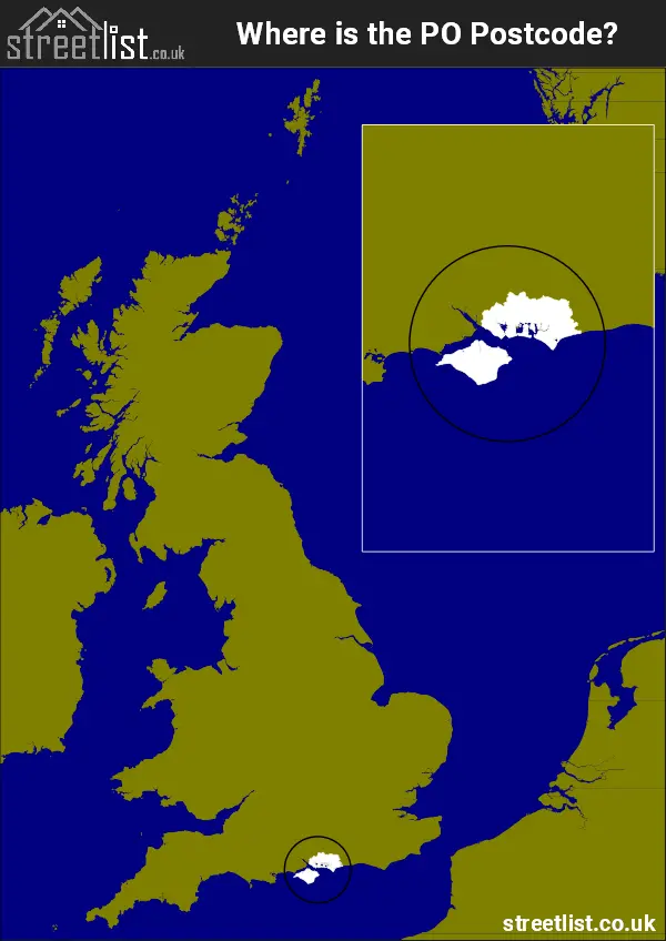
Where is the PO Postcode Area?
The PO Portsmouth Postcode is in the South East of England The postal area borders the following neighbouring postal areas: GU - Guildford, SO - Southampton and BN - Brighton, It also borders The Solent, Portsmouth Harbour, Chichester Harbour, Langstone Harbour and The English Channel.
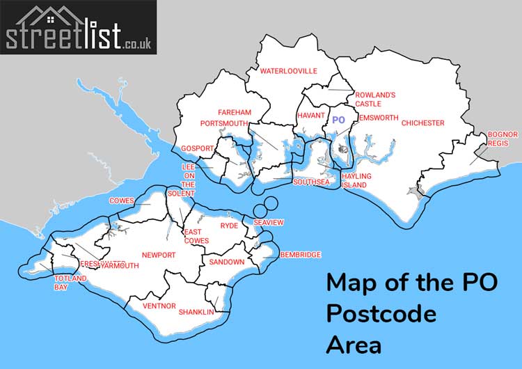
Map of the PO Portsmouth Postcode Area
Explore the PO Portsmouth postcode area by using our interactive map.
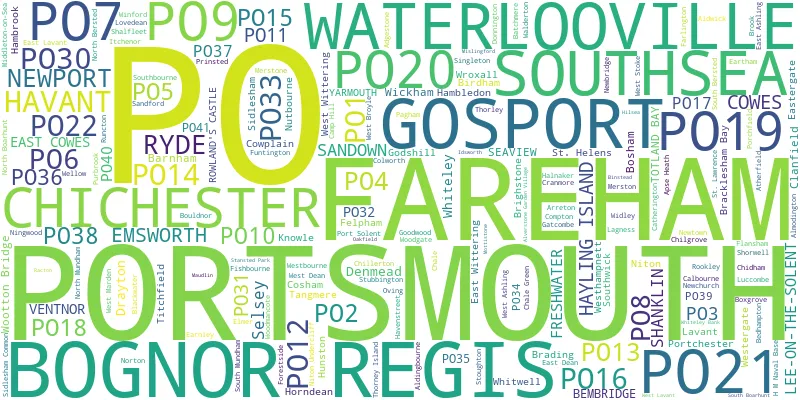
Postcode Districts within the PO Portsmouth Postcode Area
There are 34 postcode districts within the Portsmouth postcode area
A map showing the boundary of in relation to other areas
There are 20 towns within the Portsmouth postcode area.
| Unit | Area² |
|---|---|
| Hectares | 1,103,137² |
| Miles | 4,259² |
| Feet | 118,740,563,543² |
| Kilometres | 11,031² |
Postal Delivery Offices serving the PO Portsmouth Postcode Area
- Bembridge Scale Payment Delivery Office
- Bognor Regis Delivery Office
- Chale Scale Payment Delivery Office
- Chichester Delivery Office
- Cosham Delivery Office
- Emsworth Delivery Office
- Fareham Delivery Office
- Freshwater Delivery Office
- Gosport Delivery Office
- Havant Delivery Office
- Hayling Island Delivery Office
- Newport (iow) Delivery Office
- Niton Scale Payment Delivery Office
- Portsmouth Delivery Office
- Rowlands Castle Scale Payment Delivery Office
- Ryde Delivery Office
- Sandown Delivery Office
- Selsey Delivery Office
- Ventnor Delivery Office
- Waterlooville Delivery Office
- Whitwell Scale Payment Delivery Office
Councils with Postcodes in PO
Towns and Villages within the PO Portsmouth Postcode Area
- Adgestone - village
- Aldingbourne - village
- Almodington - village
- Alverstone - village
- Alverstone Garden Village - village
- Apse Heath - village
- Arreton - village
- Barnham - village
- Bembridge - village
- Birdham - village
- Blackwater - village
- Blendworth - village
- Bognor Regis - town
- Bosham - village
- Bosham Hoe - village
- Bouldnor - village
- Boxgrove - village
- Brading - town
- Brighstone - village
- Broadbridge - village
- Brook - village
- Burridge - village
- Calbourne - village
- Catherington - village
- Chale - village
- Chale Green - village
- Charlton - village
- Chichester - city
- Chidham - village
- Chilgrove - village
- Chillerton - village
- Clanfield - village
- Colwell - village
- Compton - village
- Cowes - town
- Cowplain - town
- Cranmore - village
- Denmead - village
- Durrants - village
- Earnley - village
- East Ashling - village
- East Cowes - town
- East Dean - village
- East Hampnett - village
- East Lavant - village
- East Wittering - village
- Eastergate - village
- Emsworth - town
- Fareham - town
- Finchdean - village
- Fishbourne - village
- Fishbourne - village
- Flansham - village
- Fleet - village
- Fontwell - village
- Forestside - village
- Freshwater - otherSettlement
- Funtington - village
- Funtley - village
- Furzeley Corner - village
- Gatcombe - otherSettlement
- Godshill - village
- Gosport - town
- Halnaker - village
- Hambledon - village
- Hambrook - village
- Havant - town
- Havenstreet - village
- Highleigh - village
- Hill Head - village
- Hillway - village
- Horndean - town
- Hundred Acres - village
- Hunston - village
- Knowle - village
- Lee-on-the-Solent - Settlement
- Lidsey - village
- Locks Heath - village
- Maudlin - village
- Merstone - village
- Mid Lavant - village
- Nettlestone - village
- Newbridge - village
- Newchurch - village
- Newport - town
- Newtown - village
- Ningwood - village
- Niton - village
- North Boarhunt - village
- North Hayling - village
- North Mundham - village
- Northney - village
- Norton - village
- Norton - village
- Norton Green - village
- Nutbourne - village
- Oving - village
- Pagham - village
- Peel Common - village
- Pondwell - village
- Porchfield - village
- Portchester - town
- Portsmouth - city
- Purbrook - Settlement
- Rew Street - village
- Rookley - village
- Rowlands Castle - village
- Runcton - village
- Ryde - town
- Sandford - village
- Sandown - town
- Seaview - village
- Segensworth - village
- Selsey - town
- Shalfleet - village
- Shanklin - town
- Shipton Green - village
- Shorwell - village
- Shripney - village
- Sidlesham - village
- Sidlesham Common - village
- Singleton - village
- Soberton Heath - village
- Somerley - village
- South Hayling - Urban Area
- Southbourne - village
- Southsea - town
- Southwick - village
- Spring Vale - village
- St Helens - village
- Stoke - village
- Stoughton - village
- Street End - village
- Stubbington - village
- Swanwick - village
- Tangmere - village
- Thorley - village
- Thorley Street - village
- Thorney Island - village
- Titchfield - village
- Titchfield Common - Settlement
- Titchfield Park - Settlement
- Totland - village
- Upton - village
- Ventnor - town
- Walderton - village
- Waterlooville - Urban Area
- Wellow - village
- West Ashling - village
- West Barnham - village
- West Dean - village
- West Itchenor - village
- West Marden - village
- West Stoke - village
- West Thorney - village
- West Wittering - village
- Westbourne - village
- Westergate - village
- Westerton - village
- Westhampnett - village
- Westlands - village
- Whippingham - village
- Whiteley - Urban Area
- Whiteley Bank - village
- Whitwell - village
- Wickham - town
- Winford - village
- Woodmancote - village
- Wootton - village
- Wroxall - village
- Yarmouth - town
- Yaverland - village