The PO10 postcode district is a postal district located in the PO Portsmouth postcode area with a population of 20,280 residents according to the 2021 England and Wales Census.
The area of the PO10 postcode district is 9.11 square miles which is 23.60 square kilometres or 5,831.05 acres.
Currently, the PO10 district has about 585 postcode units spread across 2 geographic postcode sectors.
Given that each sector allows for 400 unique postcode combinations, the district has a capacity of 800 postcodes. With 585 postcodes already in use, this leaves 215 units available.
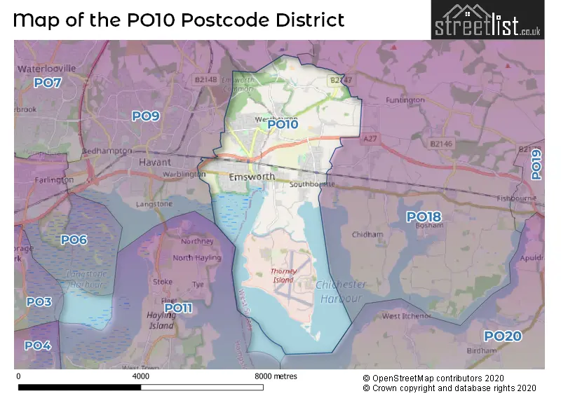
The largest settlement in the PO10 postal code is EMSWORTH followed by Southbourne, and Westbourne.
The postcode area has a boundary with Langstone Harbour and Chichester Harbour.
The PO10 Postcode shares a border with PO9 (HAVANT, ROWLAND'S CASTLE) and PO18 (Bosham, Hambrook, Lavant).
In the PO10 postcode district, Emsworth is the primary settlement with the highest count. It is located in Hampshire, England. The most significant post town in the district is also Emsworth. Other significant settlements in the district include Aldsworth, Prinsted, Southbourne, Thorney Island, Westbourne, and Woodmancote, all located in West Sussex, England.
For the district PO10, we have data on 3 postcode sectors. Here's a breakdown: The sector PO10 7, covers Emsworth in Hampshire. The sector PO10 8, covers Emsworth and Westbourne in West Sussex. The sector PO10 9 is non-geographic. It's often designated for PO Boxes, large organisations, or special services.


Map of the PO10 Postcode District
Explore the PO10 postcode district by using our free interactive map.
When it comes to local government, postal geography often disregards political borders. However, for a breakdown in the PO10 District: the district mostly encompasses the Havant District (B) (303 postcodes), and finally, the Chichester District area (291 postcodes).
Recent House Sales in PO10
| Date | Price | Address |
|---|---|---|
| 10/10/2023 | £445,000 | Thorney Road, Emsworth, PO10 8BL |
| 05/10/2023 | £445,000 | Gordon Road, Southbourne, Emsworth, PO10 8AZ |
| 29/09/2023 | £950,000 | Stein Road, Southbourne, Emsworth, PO10 8LB |
| 22/09/2023 | £165,000 | Stein Road, Southbourne, Emsworth, PO10 8LL |
| 12/09/2023 | £265,000 | New Brighton Road, Emsworth, PO10 7EW |
| 08/09/2023 | £325,000 | River Street, Emsworth, PO10 8TG |
| 05/09/2023 | £725,000 | Watersedge Gardens, Emsworth, PO10 7EU |
| 29/08/2023 | £410,000 | Hurstwood Avenue, Southbourne, Emsworth, PO10 8LN |
| 24/08/2023 | £647,740 | Fairlea Road, Emsworth, PO10 7SX |
| 23/08/2023 | £642,500 | Nore Crescent, Emsworth, PO10 7NB |
Weather Forecast for PO10
Press Button to Show Forecast for Emsworth
| Time Period | Icon | Description | Temperature | Rain Probability | Wind |
|---|---|---|---|---|---|
| 09:00 to 12:00 | Cloudy | 10.0°C (feels like 9.0°C) | 33.00% | ENE 9 mph | |
| 12:00 to 15:00 | Light rain shower (day) | 12.0°C (feels like 11.0°C) | 34.00% | ESE 9 mph | |
| 15:00 to 18:00 | Cloudy | 13.0°C (feels like 11.0°C) | 52.00% | E 9 mph | |
| 18:00 to 21:00 | Heavy rain | 11.0°C (feels like 9.0°C) | 85.00% | NE 9 mph | |
| 21:00 to 00:00 | Heavy rain | 10.0°C (feels like 7.0°C) | 84.00% | NNE 13 mph |
Press Button to Show Forecast for Emsworth
| Time Period | Icon | Description | Temperature | Rain Probability | Wind |
|---|---|---|---|---|---|
| 00:00 to 03:00 | Heavy rain | 9.0°C (feels like 7.0°C) | 83.00% | NNE 13 mph | |
| 03:00 to 06:00 | Heavy rain | 9.0°C (feels like 7.0°C) | 93.00% | N 9 mph | |
| 06:00 to 09:00 | Heavy rain | 8.0°C (feels like 6.0°C) | 89.00% | NNW 11 mph | |
| 09:00 to 12:00 | Heavy rain | 9.0°C (feels like 5.0°C) | 83.00% | NW 13 mph | |
| 12:00 to 15:00 | Light rain | 10.0°C (feels like 6.0°C) | 47.00% | WNW 16 mph | |
| 15:00 to 18:00 | Cloudy | 11.0°C (feels like 9.0°C) | 11.00% | W 11 mph | |
| 18:00 to 21:00 | Cloudy | 11.0°C (feels like 8.0°C) | 5.00% | WSW 11 mph | |
| 21:00 to 00:00 | Partly cloudy (night) | 9.0°C (feels like 8.0°C) | 1.00% | SW 9 mph |
Press Button to Show Forecast for Emsworth
| Time Period | Icon | Description | Temperature | Rain Probability | Wind |
|---|---|---|---|---|---|
| 00:00 to 03:00 | Clear night | 9.0°C (feels like 7.0°C) | 1.00% | WSW 9 mph | |
| 03:00 to 06:00 | Clear night | 8.0°C (feels like 6.0°C) | 1.00% | SW 7 mph | |
| 06:00 to 09:00 | Sunny day | 9.0°C (feels like 7.0°C) | 1.00% | S 7 mph | |
| 09:00 to 12:00 | Partly cloudy (day) | 11.0°C (feels like 9.0°C) | 1.00% | S 11 mph | |
| 12:00 to 15:00 | Sunny day | 13.0°C (feels like 10.0°C) | 1.00% | S 13 mph | |
| 15:00 to 18:00 | Sunny day | 13.0°C (feels like 10.0°C) | 1.00% | S 11 mph | |
| 18:00 to 21:00 | Sunny day | 12.0°C (feels like 10.0°C) | 1.00% | SE 9 mph | |
| 21:00 to 00:00 | Clear night | 11.0°C (feels like 8.0°C) | 2.00% | SE 11 mph |
Press Button to Show Forecast for Emsworth
| Time Period | Icon | Description | Temperature | Rain Probability | Wind |
|---|---|---|---|---|---|
| 00:00 to 03:00 | Clear night | 10.0°C (feels like 8.0°C) | 2.00% | SE 11 mph | |
| 03:00 to 06:00 | Clear night | 10.0°C (feels like 8.0°C) | 2.00% | SE 11 mph | |
| 06:00 to 09:00 | Sunny day | 11.0°C (feels like 9.0°C) | 4.00% | SE 11 mph | |
| 09:00 to 12:00 | Sunny day | 13.0°C (feels like 10.0°C) | 5.00% | SE 13 mph | |
| 12:00 to 15:00 | Sunny day | 14.0°C (feels like 11.0°C) | 5.00% | SE 13 mph | |
| 15:00 to 18:00 | Partly cloudy (day) | 14.0°C (feels like 12.0°C) | 6.00% | SE 13 mph | |
| 18:00 to 21:00 | Sunny day | 13.0°C (feels like 11.0°C) | 8.00% | SE 11 mph | |
| 21:00 to 00:00 | Partly cloudy (night) | 12.0°C (feels like 10.0°C) | 6.00% | SE 9 mph |
Where is the PO10 Postcode District?
The postcode district "PO10" is located in the town of Emsworth. It is situated in close proximity to several nearby towns. To the West is Havant, which is approximately 2.77 miles away. Heading in the North West direction, we have Rowland's Castle, located at a distance of about 3.12 miles. Hayling Island is situated to the South West, approximately 4.06 miles away. Moving towards the East, you will find the town of Chichester, which is approximately 5.8 miles away. Finally, to the North, there is Petersfield, located at a distance of approximately 10.97 miles. Additionally, the distance between Emsworth and London is approximately 57.07 miles.
The district is within the post town of EMSWORTH.
The sector has postcodes within the nation of England.
The PO10 Postcode District is covers the following regions.
- South Hampshire - Hampshire and Isle of Wight - South East (England)
- West Sussex (South West) - Surrey, East and West Sussex - South East (England)
| Postcode Sector | Delivery Office |
|---|---|
| PO10 7 | Emsworth Delivery Office |
| PO10 8 | Emsworth Delivery Office |
| P | O | 1 | 0 | - | X | X | X |
| P | O | 1 | 0 | Space | Numeric | Letter | Letter |
Tourist Attractions within the Postcode Area
We found 2 visitor attractions within the PO10 postcode area
| Emsworth Museum |
|---|
| Museums & Art Galleries |
| Museum and / or Art Gallery |
| View Emsworth Museum on Google Maps |
| Havant Museum |
| Museums & Art Galleries |
| Museum and / or Art Gallery |
| View Havant Museum on Google Maps |
Current Monthly Rental Prices
| # Bedrooms | Min Price | Max Price | Avg Price |
|---|---|---|---|
| 1 | £650 | £650 | £650 |
| 2 | £875 | £1,350 | £1,103 |
| 3 | £1,650 | £1,700 | £1,661 |
| 4 | £2,000 | £2,000 | £2,000 |
| 5 | £2,450 | £2,450 | £2,450 |
Current House Prices
| # Bedrooms | Min Price | Max Price | Avg Price |
|---|---|---|---|
| £385,000 | £385,000 | £385,000 | |
| 1 | £160,000 | £325,000 | £223,376 |
| 2 | £175,000 | £675,000 | £341,618 |
| 3 | £144,000 | £830,000 | £478,263 |
| 4 | £315,000 | £1,850,000 | £805,902 |
| 5 | £585,000 | £2,850,000 | £1,135,833 |
| 9 | £3,500,000 | £3,500,000 | £3,500,000 |
Estate Agents who Operate in the PO10 District
| Logo | Name | Brand Name | Address | Contact Number | Total Properties |
|---|---|---|---|---|---|
 | Emsworth | Treagust & Co | 16-18 North Street, Emsworth, Hampshire, PO10 7DG | 01243 217442 | 28 |
 | Emsworth | Borland & Borland | 9a High Street Emsworth Hampshire PO10 7AQ | 020 3835 2258 | 28 |
 | Emsworth | Gascoigne-Pees | 1 South Street Emsworth Hampshire PO10 7EG | 020 3869 5732 | 20 |
 | Emsworth | Henry Adams | 15 North Street, Emsworth, PO10 7BY | 01243 973425 | 20 |
 | Emsworth | Cubitt & West | 32 High Street Emsworth PO10 7AW | 01243 973392 | 16 |
| Type of Property | 2018 Average | 2018 Sales | 2017 Average | 2017 Sales | 2016 Average | 2016 Sales | 2015 Average | 2015 Sales |
|---|---|---|---|---|---|---|---|---|
| Detached | £513,611 | 106 | £550,149 | 110 | £543,104 | 122 | £468,312 | 133 |
| Semi-Detached | £352,306 | 79 | £345,020 | 103 | £343,575 | 69 | £314,418 | 99 |
| Terraced | £328,164 | 58 | £339,660 | 73 | £314,497 | 89 | £295,140 | 107 |
| Flats | £187,694 | 27 | £176,329 | 33 | £165,974 | 40 | £170,334 | 43 |