The PO18 postcode district is a postal district located in the PO Portsmouth postcode area with a population of 14,661 residents according to the 2021 England and Wales Census.
The area of the PO18 postcode district is 74.41 square miles which is 192.72 square kilometres or 47,620.92 acres.
Currently, the PO18 district has about 672 postcode units spread across 3 geographic postcode sectors.
Given that each sector allows for 400 unique postcode combinations, the district has a capacity of 1,200 postcodes. With 672 postcodes already in use, this leaves 528 units available.
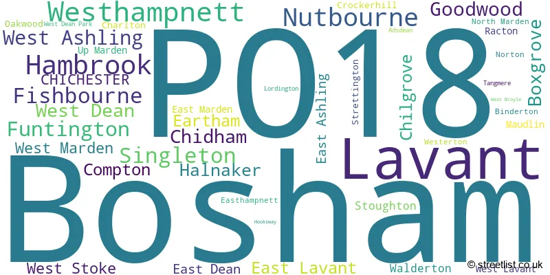
The largest settlement in the PO18 postal code is Bosham followed by Hambrook, and Lavant.
The postcode area has a boundary with Chichester Harbour.
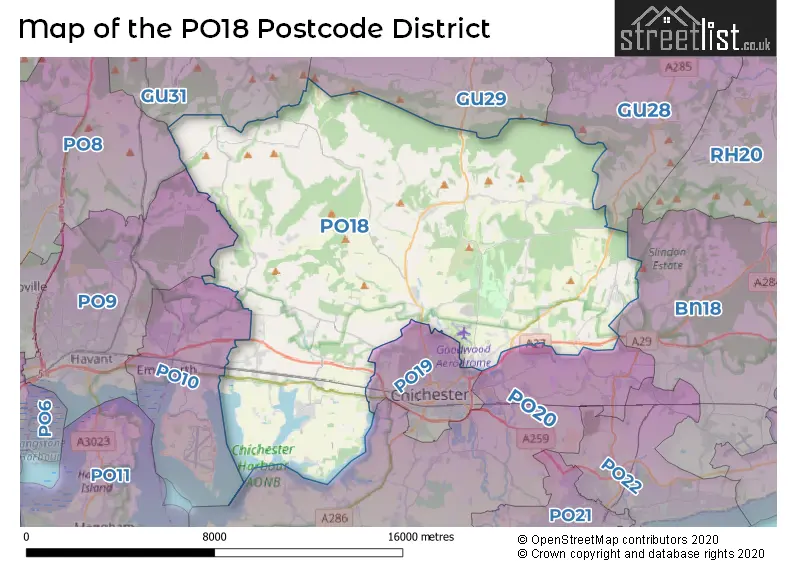
The PO18 Postcode shares a border with PO9 (HAVANT, ROWLAND'S CASTLE), PO10 (EMSWORTH, Southbourne, Westbourne), GU28 (PETWORTH, Northchapel, Graffham), GU29 (MIDHURST, Easebourne, Stedham), GU31 (PETERSFIELD, Rogate, South Harting), PO19 (CHICHESTER, West Broyle) and PO20 (Selsey, West Wittering, Bracklesham Bay).
In the PO18 postcode district, the primary settlement is Chichester, located in the county of West Sussex, England. Other significant settlements in this district include Bosham, Fishbourne, Hambrook, Nutbourne, and West Ashling. The most significant postal town in this district is Chichester.
For the district PO18, we have data on 3 postcode sectors. Here's a breakdown: The sector PO18 0, covers Lavant and Westhampnett in West Sussex. The sector PO18 8, covers Bosham and Hambrook and Nutbourne in West Sussex. The sector PO18 9, covers Funtington and Chilgrove and Compton in West Sussex.

Map of the PO18 Postcode District
Explore the PO18 postcode district by using our free interactive map.
When it comes to local government, postal geography often disregards political borders. However, for a breakdown in the PO18 District: the district mostly encompasses the Chichester District (678 postcodes), and finally, the Arun District area (6 postcodes).
Recent House Sales in PO18
| Date | Price | Address |
|---|---|---|
| 06/10/2023 | £580,000 | Main Road, Nutbourne, Chichester, PO18 8RN |
| 02/10/2023 | £425,000 | Abbotts Close, Boxgrove, Chichester, PO18 0EL |
| 29/09/2023 | £335,000 | North Road, Bosham, Chichester, PO18 8NL |
| 19/09/2023 | £375,000 | Roughmere Cottages, Lavant, Chichester, PO18 0BG |
| 18/09/2023 | £607,500 | Malthouse Lane, West Ashling, Chichester, PO18 8DZ |
| 08/09/2023 | £390,000 | Main Road, Fishbourne, Chichester, PO18 8BD |
| 06/09/2023 | £680,000 | Fairfield Road, Bosham, Chichester, PO18 8JH |
| 01/09/2023 | £197,500 | Williams Road, Bosham, Chichester, PO18 8JR |
| 01/09/2023 | £467,500 | Potters Green, Westhampnett, Chichester, PO18 0SN |
| 31/08/2023 | £500,000 | Oakford Park, Halnaker, Chichester, PO18 0BF |
Weather Forecast for PO18
Press Button to Show Forecast for Walderton
| Time Period | Icon | Description | Temperature | Rain Probability | Wind |
|---|---|---|---|---|---|
| 03:00 to 06:00 | Cloudy | 6.0°C (feels like 3.0°C) | 7.00% | NE 7 mph | |
| 06:00 to 09:00 | Cloudy | 6.0°C (feels like 2.0°C) | 9.00% | NE 9 mph | |
| 09:00 to 12:00 | Overcast | 7.0°C (feels like 4.0°C) | 12.00% | ENE 11 mph | |
| 12:00 to 15:00 | Cloudy | 10.0°C (feels like 7.0°C) | 16.00% | E 9 mph | |
| 15:00 to 18:00 | Overcast | 10.0°C (feels like 9.0°C) | 17.00% | ENE 7 mph | |
| 18:00 to 21:00 | Cloudy | 10.0°C (feels like 8.0°C) | 12.00% | E 7 mph | |
| 21:00 to 00:00 | Cloudy | 7.0°C (feels like 5.0°C) | 12.00% | E 7 mph |
Press Button to Show Forecast for Walderton
| Time Period | Icon | Description | Temperature | Rain Probability | Wind |
|---|---|---|---|---|---|
| 00:00 to 03:00 | Overcast | 6.0°C (feels like 3.0°C) | 22.00% | ENE 9 mph | |
| 03:00 to 06:00 | Light rain | 5.0°C (feels like 2.0°C) | 50.00% | ENE 9 mph | |
| 06:00 to 09:00 | Cloudy | 6.0°C (feels like 3.0°C) | 18.00% | NE 9 mph | |
| 09:00 to 12:00 | Cloudy | 9.0°C (feels like 7.0°C) | 15.00% | ENE 11 mph | |
| 12:00 to 15:00 | Cloudy | 11.0°C (feels like 9.0°C) | 15.00% | E 11 mph | |
| 15:00 to 18:00 | Light rain | 11.0°C (feels like 9.0°C) | 47.00% | ENE 11 mph | |
| 18:00 to 21:00 | Light rain | 10.0°C (feels like 8.0°C) | 50.00% | ENE 11 mph | |
| 21:00 to 00:00 | Light rain | 9.0°C (feels like 6.0°C) | 49.00% | ENE 13 mph |
Press Button to Show Forecast for Walderton
| Time Period | Icon | Description | Temperature | Rain Probability | Wind |
|---|---|---|---|---|---|
| 00:00 to 03:00 | Heavy rain | 9.0°C (feels like 6.0°C) | 76.00% | ENE 11 mph | |
| 03:00 to 06:00 | Heavy rain shower (night) | 8.0°C (feels like 6.0°C) | 61.00% | ENE 9 mph | |
| 06:00 to 09:00 | Light rain | 9.0°C (feels like 7.0°C) | 51.00% | ESE 9 mph | |
| 09:00 to 12:00 | Light rain shower (day) | 11.0°C (feels like 9.0°C) | 43.00% | SE 9 mph | |
| 12:00 to 15:00 | Light rain shower (day) | 12.0°C (feels like 10.0°C) | 42.00% | SW 11 mph | |
| 15:00 to 18:00 | Light rain shower (day) | 12.0°C (feels like 10.0°C) | 40.00% | WSW 13 mph | |
| 18:00 to 21:00 | Cloudy | 11.0°C (feels like 8.0°C) | 14.00% | WSW 11 mph | |
| 21:00 to 00:00 | Partly cloudy (night) | 9.0°C (feels like 7.0°C) | 8.00% | WSW 7 mph |
Where is the PO18 Postcode District?
According to the data, the postcode district for PO18 is located in Chichester. Chichester is surrounded by several nearby towns. These include Emsworth to the South West which is approximately 6.14 miles away, Rowland's Castle to the West which is around 6.77 miles away, Midhurst to the North at a distance of 7.88 miles, Bognor Regis to the South East which is about 8.64 miles away, Petersfield to the North West at a distance of 9.85 miles, and Arundel to the East which is approximately 10.03 miles away. Additionally, the postcode district is about 51.61 miles away from the center of London.
The district is within the post town of CHICHESTER.
The sector has postcodes within the nation of England.
The PO18 Postcode District is in the West Sussex (South West) region of Surrey, East and West Sussex within the South East (England).
| Postcode Sector | Delivery Office |
|---|---|
| PO18 0 | Chichester Delivery Office |
| PO18 8 | Chichester Delivery Office |
| PO18 9 | Chichester Delivery Office |
| P | O | 1 | 8 | - | X | X | X |
| P | O | 1 | 8 | Space | Numeric | Letter | Letter |
Current Monthly Rental Prices
| # Bedrooms | Min Price | Max Price | Avg Price |
|---|---|---|---|
| 1 | £1,085 | £1,300 | £1,196 |
| 2 | £1,250 | £1,450 | £1,350 |
| 3 | £1,100 | £2,800 | £1,752 |
| 5 | £3,850 | £4,500 | £4,175 |
Current House Prices
| # Bedrooms | Min Price | Max Price | Avg Price |
|---|---|---|---|
| £1 | £625,000 | £282,500 | |
| 1 | £122,500 | £275,000 | £205,417 |
| 2 | £172,500 | £800,000 | £384,248 |
| 3 | £205,000 | £2,250,000 | £655,528 |
| 4 | £360,000 | £2,550,000 | £917,514 |
| 5 | £375,000 | £2,950,000 | £1,435,952 |
| 6 | £2,200,000 | £2,200,000 | £2,200,000 |
| 7 | £2,500,000 | £2,500,000 | £2,500,000 |
| 18 | £3,950,000 | £3,950,000 | £3,950,000 |
Estate Agents who Operate in the PO18 District
| Logo | Name | Brand Name | Address | Contact Number | Total Properties |
|---|---|---|---|---|---|
 | Chichester | Jackson-Stops | 1 Northgate Chichester West Sussex PO19 1AT | 01243 217441 | 13 |
 | Chichester | Stride and Son | Southdown House St. Johns Street, Chichester, PO19 1XQ | 020 3835 4104 | 13 |
 | Chichester | Henry Adams | Rowan House Baffins Lane Chichester PO19 1UA | 01243 973395 | 12 |
 | Chichester | Tod Anstee | The Old Coach House, 14 West Pallant Chichester PO19 1TB | 01243 523723 | 12 |
 | Chichester | Bell and Blake | 12 The Hornet, Chichester, West Sussex, PO19 7JG | 01243 215652 | 10 |
- Apuldram
- Bosham
- Bosham Hoe
- Boxgrove
- Broadbridge
- Charlton
- Chichester
- Chidham
- Cocking
- Compton
- Crockerhill
- Didling
- Eartham
- East Ashling
- East Dean
- East Hampnett
- East Harting
- East Lavant
- Fishbourne
- Fontwell
- Funtington
- Halnaker
- Hambrook
- Lordington
- Maudlin
- Mid Lavant
- Norton
- Nutbourne
- Racton
- Singleton
- Southbourne
- Stoughton
- Strettington
- Tangmere
- Walderton
- West Ashling
- West Dean
- West Lavant
- West Marden
- West Stoke
- Westerton
- Westhampnett
- Woodend
| Type of Property | 2018 Average | 2018 Sales | 2017 Average | 2017 Sales | 2016 Average | 2016 Sales | 2015 Average | 2015 Sales |
|---|---|---|---|---|---|---|---|---|
| Detached | £782,610 | 119 | £628,524 | 136 | £661,914 | 112 | £764,736 | 101 |
| Semi-Detached | £399,309 | 56 | £372,053 | 54 | £336,805 | 49 | £345,915 | 64 |
| Terraced | £364,508 | 36 | £347,941 | 48 | £334,620 | 41 | £346,311 | 45 |
| Flats | £228,568 | 25 | £227,826 | 17 | £200,295 | 22 | £215,000 | 11 |