
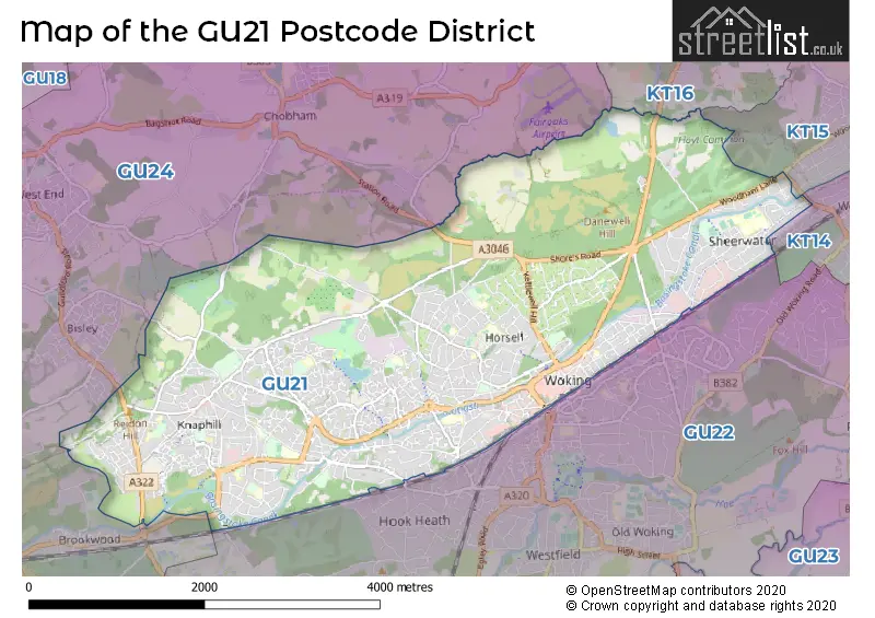
Map of the Postcode District
Explore the postcode district by using our interactive map.
Circles represent recorded crime; the larger the circle, the higher the crime rates.
Your support helps keep this site running!
If you enjoy using this website, consider buying me a coffee to help cover hosting costs.
The postcode district located in the GU Guildford postal area , GU21 has a population of 50,863 residents according to the 2021 England and Wales Census.
The area of the district is 7.93 square miles (20.53 square kilometers or 5,072.58 acres).
Where is the GU21 District?
To give you an idea where the district is located we have created the following table showing nearby towns.
Nearest Towns to GU21
| Town | Distance (miles) | Direction |
|---|---|---|
| Addlestone | 4.86 | NE |
| Chertsey | 5.63 | NE |
| Guildford | 5.99 | S |
| Weybridge | 6.12 | ENE |
| Frimley | 6.98 | W |
| Camberley | 7.17 | W |
| Egham | 7.40 | N |
| Farnborough | 7.98 | WSW |
| Staines-upon-Thames | 8.01 | NNE |
| Walton-on-Thames | 8.08 | ENE |
| Blackwater | 8.68 | W |
| Ashford | 8.97 | NE |
| Sunbury-on-Thames | 9.47 | NE |
| Aldershot | 9.49 | WSW |
| Crowthorne | 9.71 | WNW |
| Esher | 9.73 | ENE |
| Bracknell | 9.74 | NW |
| Sandhurst | 9.79 | W |
| Godalming | 9.83 | S |
The post town for this district is WOKING.
Postcode Information for District GU21 (Total Geographical Postcodes: 1307)
| Location | Post Town | Sector | Number of Postcodes |
|---|---|---|---|
| Knaphill | WOKING | GU21 2 | 274 |
| WOKING | WOKING | GU21 5 | 270 |
| WOKING | WOKING | GU21 4 | 265 |
| WOKING | WOKING | GU21 3 | 172 |
| WOKING | WOKING | GU21 6 | 110 |
| WOKING | WOKING | GU21 8 | 86 |
| WOKING | WOKING | GU21 7 | 77 |
| Horsell | WOKING | GU21 4 | 41 |
| St. Johns | WOKING | GU21 8 | 7 |
| St. Johns | WOKING | GU21 7 | 4 |
| Horsell | WOKING | GU21 5 | 1 |
Retail and Shopping in GU21
The primary settlement in the GU21 postcode district is Woking, located in the county of Surrey in England. Other significant settlements in the district are Knaphill and Horsell. The post town associated with this district is Woking.
When it comes to local government, postal geography often disregards political borders. However, this district intersects the following councils: the district mostly encompasses the Woking District (B) area with a total of 1155 postal codes.
The largest settlement in the GU21 postal code is WOKING followed by Knaphill, and SHEERWATER.
The GU21 Postcode shares a border with GU24 (Chobham, West End, Bisley), GU22 (WOKING, Old Woking, Pyrford), KT14 (BYFLEET, WEST BYFLEET), KT15 (ADDLESTONE, NEW HAW) and KT16 (CHERTSEY, OTTERSHAW, Longcross).


Schools in the Sector
St John's Primary School
Phase: Primary
Address: Victoria Road , Knaphill , Woking
Postcode: GU21 2AS
Headteacher: Mrs Ellen Rinttila (Head of School)
Ofsted Rating: Requires improvement
Knaphill School
Phase: Primary
Address: High Street , Knaphill , Woking
Postcode: GU21 2QH
Headteacher: Miss Jo Concannon (Federation Headteacher)
Ofsted Rating: Good
The Knaphill Lower School
Phase: Primary
Address: Chobham Road , Knaphill , Woking
Postcode: GU21 2SX
Headteacher: Miss Joanna Concannon (Federation Headteacher)
Ofsted Rating: Outstanding
The Knaphill Lower School
Phase: Primary
Address: Chobham Road , Knaphill , Woking
Postcode: GU21 2SX
Headteacher: Miss Victoria Harbridge (Federation Headteacher)
Ofsted Rating: Requires improvement
Sythwood Primary and Nursery School
Phase: Primary
Address: Sythwood , Horsell , Woking
Postcode: GU21 3AX
Headteacher: Mrs Nicola Matheson (Head of School)
Ofsted Rating: Good
Beaufort Primary School
Phase: Primary
Address: Kirkland Avenue , Goldsworth Park , Woking
Postcode: GU21 3RG
Headteacher: Emily Ferris (Headteacher)
Ofsted Rating: Good
Horsell Village School
Phase: Primary
Address: Church Hill , Horsell , Woking
Postcode: GU21 4QQ
Headteacher: Mrs Elaine Cooper (Headteacher)
Ofsted Rating: Outstanding
The Horsell Village School
Phase: Primary
Address: Church Hill , Horsell , Woking
Postcode: GU21 4QQ
Headteacher: Mrs Jane Reeve (Headteacher)
Ofsted Rating: Good
Horsell CofE Aided Junior School
Phase: Primary
Address: Meadway Drive , Horsell , Woking
Postcode: GU21 4TA
Headteacher: Mrs Celia Wand (Headteacher)
Ofsted Rating: Good
Woking High School
Phase: Secondary
Address: Morton Road , Horsell , Woking
Postcode: GU21 4TJ
Headteacher: Mrs Maiken Walter (Headteacher)
Ofsted Rating: Good
Maybury Primary School
Phase: Primary
Address: Walton Road , Woking
Postcode: GU21 5DW
Headteacher: Mrs Amanda Merritt (Headteacher)
Ofsted Rating: Good
Maybury Primary School
Phase: Primary
Address: Walton Road , Woking
Postcode: GU21 5DW
Headteacher: Mrs Amanda Merritt (Headteacher)
Ofsted Rating: Good
Broadmere Primary Academy
Phase: Primary
Address: Devonshire Avenue , Sheerwater , Woking
Postcode: GU21 5QE
Headteacher: Mrs Mandy McDowall (Principal)
Ofsted Rating: Good
The Bishop David Brown School
Phase: Secondary
Address: Albert Drive , Woking
Postcode: GU21 5RF
Headteacher: Mr James Rodgers (Headteacher)
Ofsted Rating: Good
Goldsworth Primary School
Phase: Primary
Address: Bridge Barn Lane , Woking
Postcode: GU21 6NL
Headteacher: Mrs Pauline Alexander (Headteacher)
Ofsted Rating: Outstanding
Goldsworth Primary School
Phase: Primary
Address: Bridge Barn Lane , Woking
Postcode: GU21 6NL
Headteacher: Mrs Gill Kozlowski (Head of School)
Ofsted Rating: Good
North West Surrey Short Stay School
Phase: Not applicable
Address: 45 Kingsway , Woking
Postcode: GU21 6NT
Headteacher: Mrs Miranda Younger (Headteacher)
Ofsted Rating: Good
The Winston Churchill School A Specialist Sports College
Phase: Secondary
Address: Hermitage Road , St Johns , Woking
Postcode: GU21 8TL
Headteacher: Mrs Zoe Johnson-Walker (Headteacher)
Ofsted Rating: Good
St Hugh of Lincoln Catholic Primary School
Phase: Primary
Address: Five Oaks Close , St John's , Woking
Postcode: GU21 8TU
Headteacher: Mr Michael George (Headteacher)
Ofsted Rating: Good
St Hugh of Lincoln Catholic Primary School
Phase: Primary
Address: Five Oaks Close , St John's , Woking
Postcode: GU21 8TU
Headteacher: Mrs Catherine Grace (Headteacher)
Ofsted Rating: Good
The Hermitage School
Phase: Primary
Address: Oakwood Road , St John's , Woking
Postcode: GU21 8UU
Headteacher: Mrs Clare Spires (Headteacher)
Ofsted Rating: Good
The Oaktree School
Phase: Primary
Address: Gorsewood Road , St John's , Woking
Postcode: GU21 8WT
Headteacher: Mrs Glen Allder (Headteacher)
Ofsted Rating: Outstanding
The Oaktree School
Phase: Primary
Address: Gorsewood Road , St John's , Woking
Postcode: GU21 8WT
Headteacher: Mrs Clare Spires (Headteacher)
Ofsted Rating: Requires improvement
Stations in the Sector
No stations found in this postcode district.
Accessable Motorway Junctions
M25 J11
Average Driving Time from within the district: 9.11
Average Driving Distance: 5.91
Number of Postcodes that can access the Motorway Junction: 1140
M3 J3
Average Driving Time from within the district: 9.38
Average Driving Distance: 6.16
Number of Postcodes that can access the Motorway Junction: 1140
M25 J12
Average Driving Time from within the district: 11.01
Average Driving Distance: 7.93
Number of Postcodes that can access the Motorway Junction: 1100
M3 J2
Average Driving Time from within the district: 11.12
Average Driving Distance: 7.99
Number of Postcodes that can access the Motorway Junction: 1140
M3 J4
Average Driving Time from within the district: 11.55
Average Driving Distance: 9.18
Number of Postcodes that can access the Motorway Junction: 297
M25 J10
Average Driving Time from within the district: 12.49
Average Driving Distance: 8.41
Number of Postcodes that can access the Motorway Junction: 871
M3 J4A
Average Driving Time from within the district: 13.45
Average Driving Distance: 10.69
Number of Postcodes that can access the Motorway Junction: 12
Weather Forecast for Woking
| Time Period | Icon | Description | Temperature | Rain Probability | Wind |
|---|---|---|---|---|---|
| 12:00 to 15:00 | Cloudy | 14.0°C (feels like 13.0°C) | 14.00% | SW 11 mph | |
| 15:00 to 18:00 | Partly cloudy (day) | 15.0°C (feels like 14.0°C) | 3.00% | SW 7 mph | |
| 18:00 to 21:00 | Clear night | 12.0°C (feels like 11.0°C) | 1.00% | SW 4 mph | |
| 21:00 to 00:00 | Clear night | 10.0°C (feels like 10.0°C) | 3.00% | SW 4 mph |
| Time Period | Icon | Description | Temperature | Rain Probability | Wind |
|---|---|---|---|---|---|
| 00:00 to 03:00 | Partly cloudy (night) | 9.0°C (feels like 9.0°C) | 16.00% | SSW 4 mph | |
| 03:00 to 06:00 | Fog | 9.0°C (feels like 8.0°C) | 17.00% | SSW 2 mph | |
| 06:00 to 09:00 | Fog | 9.0°C (feels like 8.0°C) | 17.00% | S 4 mph | |
| 09:00 to 12:00 | Fog | 11.0°C (feels like 11.0°C) | 15.00% | S 4 mph | |
| 12:00 to 15:00 | Partly cloudy (day) | 15.0°C (feels like 14.0°C) | 2.00% | SSW 9 mph | |
| 15:00 to 18:00 | Partly cloudy (day) | 15.0°C (feels like 14.0°C) | 4.00% | S 9 mph | |
| 18:00 to 21:00 | Clear night | 12.0°C (feels like 10.0°C) | 0.00% | SSE 7 mph | |
| 21:00 to 00:00 | Clear night | 10.0°C (feels like 9.0°C) | 0.00% | SE 7 mph |
| Time Period | Icon | Description | Temperature | Rain Probability | Wind |
|---|---|---|---|---|---|
| 00:00 to 03:00 | Clear night | 10.0°C (feels like 9.0°C) | 0.00% | SE 9 mph | |
| 03:00 to 06:00 | Clear night | 10.0°C (feels like 9.0°C) | 1.00% | SE 9 mph | |
| 06:00 to 09:00 | Clear night | 10.0°C (feels like 8.0°C) | 1.00% | SSE 9 mph | |
| 09:00 to 12:00 | Partly cloudy (day) | 13.0°C (feels like 11.0°C) | 1.00% | SSE 11 mph | |
| 12:00 to 15:00 | Cloudy | 15.0°C (feels like 13.0°C) | 6.00% | S 13 mph | |
| 15:00 to 18:00 | Partly cloudy (day) | 15.0°C (feels like 13.0°C) | 3.00% | S 13 mph | |
| 18:00 to 21:00 | Partly cloudy (night) | 14.0°C (feels like 12.0°C) | 5.00% | SSE 11 mph | |
| 21:00 to 00:00 | Partly cloudy (night) | 15.0°C (feels like 13.0°C) | 9.00% | S 13 mph |
| Time Period | Icon | Description | Temperature | Rain Probability | Wind |
|---|---|---|---|---|---|
| 00:00 to 03:00 | Light rain shower (night) | 15.0°C (feels like 12.0°C) | 42.00% | S 13 mph | |
| 03:00 to 06:00 | Light rain | 13.0°C (feels like 11.0°C) | 46.00% | SSW 9 mph | |
| 06:00 to 09:00 | Light rain shower (night) | 11.0°C (feels like 10.0°C) | 32.00% | SSW 9 mph | |
| 09:00 to 12:00 | Partly cloudy (day) | 12.0°C (feels like 10.0°C) | 4.00% | SSW 11 mph | |
| 12:00 to 15:00 | Partly cloudy (day) | 13.0°C (feels like 11.0°C) | 10.00% | SW 13 mph | |
| 15:00 to 18:00 | Partly cloudy (day) | 13.0°C (feels like 10.0°C) | 10.00% | SW 13 mph | |
| 18:00 to 21:00 | Clear night | 11.0°C (feels like 8.0°C) | 3.00% | SW 11 mph | |
| 21:00 to 00:00 | Clear night | 9.0°C (feels like 7.0°C) | 1.00% | SW 9 mph |
| Time Period | Icon | Description | Temperature | Rain Probability | Wind |
|---|---|---|---|---|---|
| 00:00 to 03:00 | Clear night | 8.0°C (feels like 6.0°C) | 1.00% | SW 9 mph | |
| 03:00 to 06:00 | Clear night | 8.0°C (feels like 6.0°C) | 1.00% | SW 9 mph | |
| 06:00 to 09:00 | Clear night | 8.0°C (feels like 6.0°C) | 2.00% | SW 9 mph | |
| 09:00 to 12:00 | Sunny day | 10.0°C (feels like 8.0°C) | 7.00% | SW 9 mph | |
| 12:00 to 15:00 | Partly cloudy (day) | 13.0°C (feels like 10.0°C) | 9.00% | SW 13 mph | |
| 15:00 to 18:00 | Partly cloudy (day) | 13.0°C (feels like 11.0°C) | 11.00% | SW 11 mph | |
| 18:00 to 21:00 | Clear night | 11.0°C (feels like 9.0°C) | 8.00% | SW 11 mph | |
| 21:00 to 00:00 | Clear night | 11.0°C (feels like 9.0°C) | 7.00% | SW 9 mph |
| Postal Sector | Delivery Office |
|---|---|
| GU21 2 | Knaphill Delivery Office |
| GU21 3 | Woking Delivery Office |
| GU21 4 | Woking Delivery Office |
| GU21 5 | Woking Delivery Office |
| GU21 6 | Woking Delivery Office |
| GU21 7 | Woking Delivery Office |
| GU21 8 | Woking Delivery Office |
| G | U | 2 | 1 | - | X | X | X |
| G | U | 2 | 1 | Space | Numeric | Letter | Letter |
Tourist Attractions
We found 2 visitor attractions.
| WWF Living Planet Centre |
|---|
| Visitor Centres |
| Heritage / Visitor Centre |
| View WWF Living Planet Centre on Google Maps |
| The Lightbox |
| Museums & Art Galleries |
| Museum and / or Art Gallery |
| View The Lightbox on Google Maps |
Street List for the GU21 District
Current Monthly Rental Prices
| # Bedrooms | Min Price | Max Price | Avg Price |
|---|---|---|---|
| £120 | £120 | £120 | |
| 1 | £1,050 | £1,750 | £1,250 |
| 2 | £1,100 | £3,305 | £2,201 |
| 3 | £1,650 | £4,500 | £2,332 |
| 4 | £2,200 | £3,750 | £2,838 |
| 5 | £2,700 | £4,500 | £3,363 |
| 6 | £3,250 | £3,250 | £3,250 |
Current House Prices
| # Bedrooms | Min Price | Max Price | Avg Price |
|---|---|---|---|
| £35,000 | £500,000 | £222,500 | |
| 1 | £115,000 | £325,000 | £210,430 |
| 2 | £73,500 | £580,000 | £327,387 |
| 3 | £300,000 | £1,200,000 | £509,780 |
| 4 | £435,000 | £1,695,000 | £740,398 |
| 5 | £775,000 | £1,500,000 | £1,060,000 |
| 6 | £1,100,000 | £1,750,000 | £1,525,000 |
| 9 | £750,000 | £750,000 | £750,000 |
| 17 | £1,800,000 | £1,800,000 | £1,800,000 |
Estate Agents
| Logo | Name | Brand Name | Address | Contact Number |
|---|---|---|---|---|
 | Woking | Seymours Estate Agents | 12 Commercial Way, Woking, GU21 6ET | 01483 967171 |
 | Knaphill | Seymours Estate Agents | 25 High Street, Knaphill, GU21 2PP | 01483 967619 |
 | Woking | Bourne | 36 Commercial Way, Woking, GU21 6EN | 01483 967460 |
 | Woking | Foundations Independent Est Ltd | 69-71, Commercial Way, Woking, GU21 6HN | 01483 967656 |
 | Woking | Curchods Estate Agents | Bridge House Goldsworth Rd Woking, GU21 6JT | 01483 967882 |
Yearly House Price Averages for the District
| Type of Property | 2018 Average | 2018 Sales | 2017 Average | 2017 Sales | 2016 Average | 2016 Sales | 2015 Average | 2015 Sales |
|---|---|---|---|---|---|---|---|---|
| Detached | £718,955 | 196 | £752,172 | 220 | £670,785 | 172 | £648,108 | 229 |
| Semi-Detached | £447,472 | 184 | £438,260 | 186 | £428,244 | 206 | £410,792 | 175 |
| Terraced | £351,302 | 254 | £353,548 | 218 | £361,083 | 274 | £306,859 | 253 |
| Flats | £271,797 | 235 | £254,321 | 162 | £259,280 | 208 | £240,158 | 266 |