The KT15 postcode district is a postal district located in the KT Kingston upon Thames postcode area with a population of 30,173 residents according to the 2021 England and Wales Census.
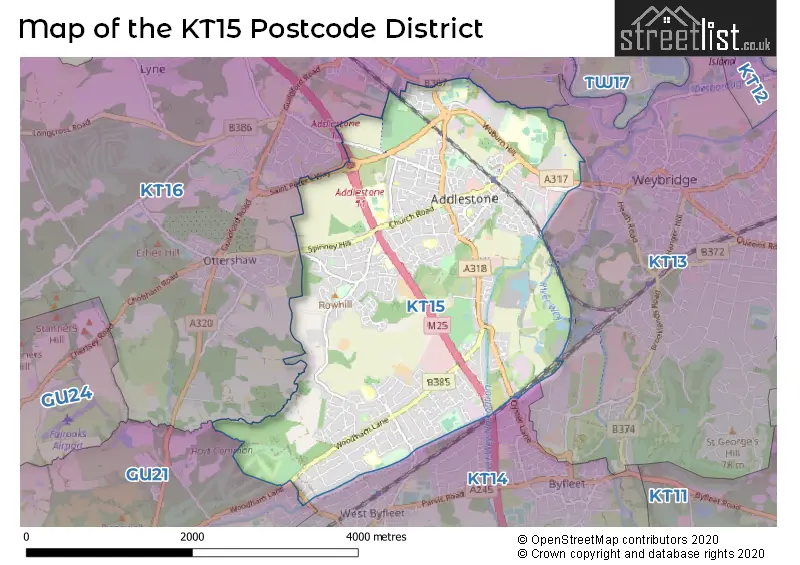
Map of the KT15 Postcode
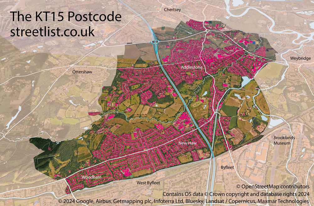
The area of the KT15 postcode district is 5.16 square miles which is 13.36 square kilometres or 3,300.80 acres.
Currently, the KT15 district has about 764 postcode units spread across 3 geographic postcode sectors.
Given that each sector allows for 400 unique postcode combinations, the district has a capacity of 1,200 postcodes. With 764 postcodes already in use, this leaves 436 units available.
The largest settlements in the KT15 postal code are ADDLESTONE and NEW HAW.
The KT15 Postcode shares a border with GU21 (WOKING, Knaphill, SHEERWATER), KT13 (WEYBRIDGE), KT14 (BYFLEET, WEST BYFLEET) and KT16 (CHERTSEY, OTTERSHAW, Longcross).
The primary settlement in the KT15 postcode district is Addlestone, which is located in the county of Surrey in England. Other significant settlements in this postcode district include Bourne Business Park, New Haw, and Woodham. The most significant post town in this district is Addlestone.
For the district KT15, we have data on 4 postcode sectors. Here's a breakdown: The sector KT15 1, covers Addlestone in Surrey. The sector KT15 2, covers Addlestone in Surrey. The sector KT15 3, covers New Haw and Woodham in Surrey. The sector KT15 9 is non-geographic. It's often designated for PO Boxes, large organisations, or special services.


Map of the KT15 Postcode District
Explore the KT15 postcode district by using our free interactive map.
When it comes to local government, postal geography often disregards political borders. However, for a breakdown in the KT15 District: the district mostly encompasses the Runnymede District (B) (756 postcodes), and finally, the Woking District (B) area (9 postcodes).
Recent House Sales in KT15
| Date | Price | Address |
|---|---|---|
| 02/10/2023 | £475,000 | Audley Close, Addlestone, KT15 1SD |
| 21/09/2023 | £408,000 | Bourneside Road, Addlestone, KT15 2JX |
| 14/09/2023 | £415,000 | Conquest Road, Addlestone, KT15 1SN |
| 14/09/2023 | £790,000 | Woodham Lane, Woodham, Addlestone, KT15 3QE |
| 04/09/2023 | £590,000 | Linden Close, New Haw, Addlestone, KT15 3HG |
| 04/09/2023 | £380,000 | Sheerwater Road, Woodham, Addlestone, KT15 3DD |
| 01/09/2023 | £230,000 | High Street, Addlestone, KT15 1UA |
| 31/08/2023 | £450,000 | Meadow Way, Addlestone, KT15 1UF |
| 29/08/2023 | £182,500 | Station Road, Addlestone, KT15 2BD |
| 29/08/2023 | £642,500 | Liberty Lane, Addlestone, KT15 1NW |
Weather Forecast for KT15
Press Button to Show Forecast for Addlestone
| Time Period | Icon | Description | Temperature | Rain Probability | Wind |
|---|---|---|---|---|---|
| 12:00 to 15:00 | Cloudy | 11.0°C (feels like 9.0°C) | 12.00% | NE 9 mph | |
| 15:00 to 18:00 | Cloudy | 12.0°C (feels like 11.0°C) | 51.00% | ENE 7 mph | |
| 18:00 to 21:00 | Cloudy | 11.0°C (feels like 10.0°C) | 62.00% | NE 9 mph | |
| 21:00 to 00:00 | Heavy rain | 10.0°C (feels like 8.0°C) | 81.00% | NE 9 mph |
Press Button to Show Forecast for Addlestone
| Time Period | Icon | Description | Temperature | Rain Probability | Wind |
|---|---|---|---|---|---|
| 00:00 to 03:00 | Heavy rain | 9.0°C (feels like 6.0°C) | 86.00% | NNE 11 mph | |
| 03:00 to 06:00 | Heavy rain | 8.0°C (feels like 6.0°C) | 89.00% | NNE 9 mph | |
| 06:00 to 09:00 | Heavy rain | 8.0°C (feels like 6.0°C) | 87.00% | N 7 mph | |
| 09:00 to 12:00 | Light rain | 9.0°C (feels like 6.0°C) | 60.00% | NW 9 mph | |
| 12:00 to 15:00 | Light rain | 10.0°C (feels like 7.0°C) | 56.00% | WNW 11 mph | |
| 15:00 to 18:00 | Cloudy | 11.0°C (feels like 9.0°C) | 19.00% | W 9 mph | |
| 18:00 to 21:00 | Cloudy | 11.0°C (feels like 9.0°C) | 8.00% | W 9 mph | |
| 21:00 to 00:00 | Partly cloudy (night) | 8.0°C (feels like 7.0°C) | 3.00% | SW 7 mph |
Press Button to Show Forecast for Addlestone
| Time Period | Icon | Description | Temperature | Rain Probability | Wind |
|---|---|---|---|---|---|
| 00:00 to 03:00 | Clear night | 7.0°C (feels like 5.0°C) | 2.00% | SSW 7 mph | |
| 03:00 to 06:00 | Clear night | 6.0°C (feels like 4.0°C) | 1.00% | SSW 4 mph | |
| 06:00 to 09:00 | Sunny day | 7.0°C (feels like 5.0°C) | 1.00% | S 4 mph | |
| 09:00 to 12:00 | Partly cloudy (day) | 12.0°C (feels like 10.0°C) | 5.00% | S 9 mph | |
| 12:00 to 15:00 | Cloudy | 14.0°C (feels like 11.0°C) | 8.00% | S 11 mph | |
| 15:00 to 18:00 | Partly cloudy (day) | 14.0°C (feels like 12.0°C) | 2.00% | S 11 mph | |
| 18:00 to 21:00 | Sunny day | 13.0°C (feels like 11.0°C) | 1.00% | S 9 mph | |
| 21:00 to 00:00 | Clear night | 10.0°C (feels like 8.0°C) | 2.00% | SSE 7 mph |
Press Button to Show Forecast for Addlestone
| Time Period | Icon | Description | Temperature | Rain Probability | Wind |
|---|---|---|---|---|---|
| 00:00 to 03:00 | Clear night | 9.0°C (feels like 7.0°C) | 3.00% | SE 7 mph | |
| 03:00 to 06:00 | Clear night | 8.0°C (feels like 7.0°C) | 3.00% | SE 7 mph | |
| 06:00 to 09:00 | Sunny day | 9.0°C (feels like 8.0°C) | 5.00% | SE 7 mph | |
| 09:00 to 12:00 | Partly cloudy (day) | 14.0°C (feels like 12.0°C) | 4.00% | SE 9 mph | |
| 12:00 to 15:00 | Cloudy | 16.0°C (feels like 14.0°C) | 12.00% | SE 9 mph | |
| 15:00 to 18:00 | Cloudy | 17.0°C (feels like 15.0°C) | 11.00% | SE 9 mph | |
| 18:00 to 21:00 | Cloudy | 15.0°C (feels like 14.0°C) | 10.00% | SE 7 mph | |
| 21:00 to 00:00 | Cloudy | 12.0°C (feels like 11.0°C) | 9.00% | SE 7 mph |
Where is the KT15 Postcode District?
The postcode district KT15 is located in the town of Addlestone. It is nearby the towns of New Haw, Meadowlands, Chertsey, West Byfleet, and Ottershaw. Additionally, it is approximately 18.89 miles away from the center of London.
The district is within the post town of ADDLESTONE.
The sector has postcodes within the nation of England.
The KT15 Postcode District is in the West Surrey region of Surrey, East and West Sussex within the South East (England).
| Postcode Sector | Delivery Office |
|---|---|
| KT15 1 | Addlestone Delivery Office |
| KT15 2 | Addlestone Delivery Office |
| KT15 3 | Addlestone Delivery Office |
| K | T | 1 | 5 | - | X | X | X |
| K | T | 1 | 5 | Space | Numeric | Letter | Letter |
Current Monthly Rental Prices
| # Bedrooms | Min Price | Max Price | Avg Price |
|---|---|---|---|
| £795 | £1,000 | £936 | |
| 1 | £700 | £1,340 | £1,055 |
| 2 | £1,750 | £3,495 | £2,415 |
| 3 | £1,750 | £2,375 | £2,075 |
| 4 | £2,995 | £3,495 | £3,245 |
| 5 | £3,750 | £3,750 | £3,750 |
Current House Prices
| # Bedrooms | Min Price | Max Price | Avg Price |
|---|---|---|---|
| 1 | £60,000 | £274,950 | £171,441 |
| 2 | £130,000 | £550,000 | £321,114 |
| 3 | £400,000 | £715,000 | £534,873 |
| 4 | £450,000 | £1,000,000 | £699,839 |
| 5 | £599,950 | £1,500,000 | £909,612 |
| 6 | £1,100,000 | £2,000,000 | £1,512,375 |
Estate Agents who Operate in the KT15 District
| Logo | Name | Brand Name | Address | Contact Number | Total Properties |
|---|---|---|---|---|---|
 | Addlestone | Hodders | 114 Station Road, Addlestone, KT15 2BQ | 01932 548307 | 27 |
 | New Haw | Curchods Estate Agents | 300 a) Woodham Lane, New Haw, KT15 3NT | 01932 504619 | 26 |
 | Addlestone | Seymours Estate Agents | 126 Station Road, Addlestone, KT15 2BQ | 01932 501634 | 22 |
 | Addlestone | Grants Independent | 155 Station Road Addlestone KT15 2AT | 01932 504287 | 20 |
 | New Haw | Richard State Independent Estate Agents | 28 The Broadway, New Haw, Addlestone, Surrey, KT15 3HA | 01932 506224 | 20 |
| Type of Property | 2018 Average | 2018 Sales | 2017 Average | 2017 Sales | 2016 Average | 2016 Sales | 2015 Average | 2015 Sales |
|---|---|---|---|---|---|---|---|---|
| Detached | £591,976 | 86 | £594,180 | 110 | £554,484 | 95 | £562,309 | 129 |
| Semi-Detached | £432,396 | 179 | £438,902 | 170 | £419,935 | 168 | £379,189 | 166 |
| Terraced | £379,600 | 72 | £399,108 | 94 | £378,213 | 83 | £315,775 | 92 |
| Flats | £265,236 | 119 | £259,119 | 165 | £245,015 | 142 | £222,480 | 157 |