The GU19 postcode district is a postal district located in the GU Guildford postcode area with a population of 6,122 residents according to the 2021 England and Wales Census.
The area of the GU19 postcode district is 4.33 square miles which is 11.21 square kilometres or 2,768.86 acres.
Currently, the GU19 district has about 168 postcode units spread across 1 geographic postcode sectors.
Given that each sector allows for 400 unique postcode combinations, the district has a capacity of 400 postcodes. With 168 postcodes already in use, this leaves 232 units available.
The GU19 postal code covers the settlement of BAGSHOT.
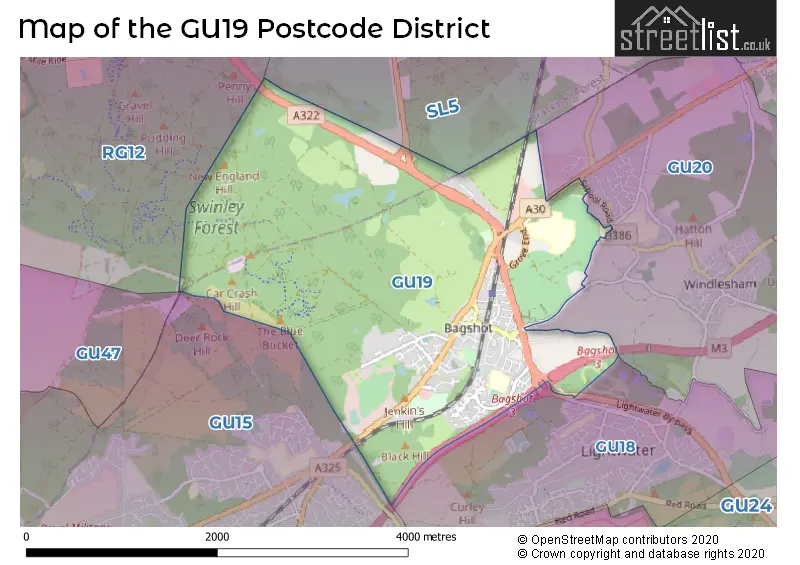
The GU19 Postcode shares a border with GU20 (WINDLESHAM) and GU18 (LIGHTWATER).
The primary settlement in the GU19 postcode district is Bagshot, which is located in the county of Surrey. Bagshot is the main focus as it has the highest count of data. Berkshire is also mentioned as another county in the data, but it represents a small proportion and therefore is not emphasized. The significant post town for the data is Bagshot.
For the district GU19, we have data on 1 postcode sectors. Here's a breakdown: The sector GU19 5, covers Bagshot in Surrey.
GU19 Postcode Sectors


Map of the GU19 Postcode District
Explore the GU19 postcode district by using our free interactive map.
When it comes to local government, postal geography often disregards political borders. However, for a breakdown in the GU19 District: the district mostly encompasses the Surrey Heath District (B) area with a total of 173 postcodes.
Recent House Sales in GU19
| Date | Price | Address |
|---|---|---|
| 28/09/2023 | £397,500 | Hawkesworth Drive, Bagshot, GU19 5QY |
| 04/09/2023 | £409,000 | Gloucester Road, Bagshot, GU19 5LT |
| 25/08/2023 | £390,000 | Gloucester Road, Bagshot, GU19 5LT |
| 23/08/2023 | £190,000 | Horsebrass Drive, Bagshot, GU19 5RB |
| 07/08/2023 | £116,000 | Hart Dene Court, Bagshot, GU19 5AJ |
| 28/07/2023 | £350,000 | Gloucester Road, Bagshot, GU19 5LT |
| 21/07/2023 | £1,300,000 | London Road, Bagshot, GU19 5HN |
| 19/07/2023 | £460,000 | Station Road, Bagshot, GU19 5AS |
| 14/07/2023 | £320,000 | London Road, Bagshot, GU19 5DH |
| 14/07/2023 | £187,000 | Laird Court, Bagshot, GU19 5QN |
Where is the GU19 Postcode District?
The GU19 postcode district is situated in Bagshot, a town in the South East region of the UK. Bagshot is located nearby several towns, including Lightwater to the South East (1.9 miles away), Windlesham to the East (2 miles away), Camberley to the South West (2.6 miles away), Ascot to the North East (3.3 miles away), Bracknell to the North West (3.8 miles away), and Crowthorne to the West (4.4 miles away). Additionally, Bagshot is approximately 26.7 miles away from the center of London.
The district is within the post town of BAGSHOT.
The sector has postcodes within the nation of England.
The GU19 Postcode District is covers the following regions.
- West Surrey - Surrey, East and West Sussex - South East (England)
- Berkshire - Berkshire, Buckinghamshire and Oxfordshire - South East (England)
Weather Forecast for GU19
Press Button to Show Forecast for Bagshot
| Time Period | Icon | Description | Temperature | Rain Probability | Wind |
|---|---|---|---|---|---|
| 09:00 to 12:00 | Sunny day | 19.0°C (feels like 19.0°C) | 0.00% | E 4 mph | |
| 12:00 to 15:00 | Cloudy | 24.0°C (feels like 23.0°C) | 31.00% | SE 7 mph | |
| 15:00 to 18:00 | Partly cloudy (day) | 24.0°C (feels like 22.0°C) | 8.00% | S 7 mph | |
| 18:00 to 21:00 | Cloudy | 21.0°C (feels like 20.0°C) | 5.00% | S 7 mph | |
| 21:00 to 00:00 | Clear night | 16.0°C (feels like 16.0°C) | 2.00% | S 4 mph |
Press Button to Show Forecast for Bagshot
| Time Period | Icon | Description | Temperature | Rain Probability | Wind |
|---|---|---|---|---|---|
| 00:00 to 03:00 | Clear night | 14.0°C (feels like 13.0°C) | 3.00% | SSW 7 mph | |
| 03:00 to 06:00 | Overcast | 13.0°C (feels like 12.0°C) | 8.00% | SSW 7 mph | |
| 06:00 to 09:00 | Overcast | 12.0°C (feels like 11.0°C) | 9.00% | SSW 9 mph | |
| 09:00 to 12:00 | Cloudy | 16.0°C (feels like 14.0°C) | 4.00% | SSW 11 mph | |
| 12:00 to 15:00 | Cloudy | 18.0°C (feels like 15.0°C) | 4.00% | S 13 mph | |
| 15:00 to 18:00 | Cloudy | 18.0°C (feels like 16.0°C) | 5.00% | S 11 mph | |
| 18:00 to 21:00 | Cloudy | 17.0°C (feels like 15.0°C) | 8.00% | SSE 11 mph | |
| 21:00 to 00:00 | Light rain | 15.0°C (feels like 14.0°C) | 50.00% | SE 9 mph |
Press Button to Show Forecast for Bagshot
| Time Period | Icon | Description | Temperature | Rain Probability | Wind |
|---|---|---|---|---|---|
| 00:00 to 03:00 | Light rain | 14.0°C (feels like 13.0°C) | 49.00% | SE 9 mph | |
| 03:00 to 06:00 | Light rain | 14.0°C (feels like 12.0°C) | 56.00% | SE 9 mph | |
| 06:00 to 09:00 | Heavy rain | 13.0°C (feels like 12.0°C) | 85.00% | SE 7 mph | |
| 09:00 to 12:00 | Heavy rain | 14.0°C (feels like 13.0°C) | 88.00% | SSE 9 mph | |
| 12:00 to 15:00 | Heavy rain | 15.0°C (feels like 13.0°C) | 82.00% | S 11 mph | |
| 15:00 to 18:00 | Cloudy | 16.0°C (feels like 13.0°C) | 18.00% | S 11 mph | |
| 18:00 to 21:00 | Cloudy | 15.0°C (feels like 14.0°C) | 9.00% | SSE 9 mph | |
| 21:00 to 00:00 | Cloudy | 13.0°C (feels like 12.0°C) | 8.00% | SE 9 mph |
Press Button to Show Forecast for Bagshot
| Time Period | Icon | Description | Temperature | Rain Probability | Wind |
|---|---|---|---|---|---|
| 00:00 to 03:00 | Cloudy | 12.0°C (feels like 11.0°C) | 6.00% | SE 7 mph | |
| 03:00 to 06:00 | Clear night | 11.0°C (feels like 10.0°C) | 3.00% | SE 7 mph | |
| 06:00 to 09:00 | Partly cloudy (day) | 12.0°C (feels like 11.0°C) | 4.00% | SE 7 mph | |
| 09:00 to 12:00 | Partly cloudy (day) | 15.0°C (feels like 13.0°C) | 9.00% | SSE 11 mph | |
| 12:00 to 15:00 | Partly cloudy (day) | 17.0°C (feels like 15.0°C) | 9.00% | SSE 11 mph | |
| 15:00 to 18:00 | Partly cloudy (day) | 17.0°C (feels like 15.0°C) | 6.00% | SSE 11 mph | |
| 18:00 to 21:00 | Sunny day | 16.0°C (feels like 15.0°C) | 5.00% | SSE 7 mph | |
| 21:00 to 00:00 | Clear night | 13.0°C (feels like 12.0°C) | 3.00% | SE 4 mph |
Press Button to Show Forecast for Bagshot
| Time Period | Icon | Description | Temperature | Rain Probability | Wind |
|---|---|---|---|---|---|
| 00:00 to 03:00 | Clear night | 11.0°C (feels like 10.0°C) | 1.00% | SE 4 mph | |
| 03:00 to 06:00 | Clear night | 10.0°C (feels like 9.0°C) | 2.00% | ESE 4 mph | |
| 06:00 to 09:00 | Sunny day | 11.0°C (feels like 11.0°C) | 2.00% | E 4 mph | |
| 09:00 to 12:00 | Cloudy | 16.0°C (feels like 16.0°C) | 8.00% | E 4 mph | |
| 12:00 to 15:00 | Cloudy | 18.0°C (feels like 17.0°C) | 15.00% | SE 7 mph | |
| 15:00 to 18:00 | Light rain shower (day) | 17.0°C (feels like 17.0°C) | 35.00% | S 7 mph | |
| 18:00 to 21:00 | Light rain shower (day) | 17.0°C (feels like 16.0°C) | 33.00% | WSW 4 mph | |
| 21:00 to 00:00 | Cloudy | 14.0°C (feels like 13.0°C) | 14.00% | W 4 mph |
Postcode Sectors within the GU19 District
| Postcode Sector | Delivery Office |
|---|---|
| GU19 5 | Bagshot Scale Payment Delivery Office |
| G | U | 1 | 9 | - | X | X | X |
| G | U | 1 | 9 | Space | Numeric | Letter | Letter |
Current Monthly Rental Prices
| # Bedrooms | Min Price | Max Price | Avg Price |
|---|---|---|---|
| 1 | £995 | £1,200 | £1,098 |
| 3 | £2,000 | £2,000 | £2,000 |
| 4 | £1,850 | £3,450 | £2,383 |
Current House Prices
| # Bedrooms | Min Price | Max Price | Avg Price |
|---|---|---|---|
| 1 | £65,000 | £339,950 | £190,632 |
| 2 | £180,000 | £499,950 | £355,379 |
| 3 | £290,000 | £575,000 | £475,714 |
| 4 | £525,000 | £700,000 | £625,000 |
| 5 | £1,250,000 | £1,300,000 | £1,275,000 |
| 6 | £700,000 | £700,000 | £700,000 |
Estate Agents who Operate in the GU19 District
| Logo | Name | Brand Name | Address | Contact Number | Total Properties |
|---|---|---|---|---|---|
 | Bagshot | Winkworth | 41 High Street, Bagshot, GU19 5AF | 01276 740133 | 13 |
 | Bagshot | Howlands Sales and Lettings | 35 High Street, Bagshot, GU19 5AF | 01276 740128 | 11 |
 | Lightwater | Chancellors | 76 Guildford Road, Lightwater, GU18 5ST | 01276 740131 | 4 |
 | Camberley | Jigsaw Estates | Jigsaw Estates Limited Park Street, Camberley, GU15 3PL | 01276 740137 | 4 |
 | Camberley | Knights Property Services | 54 Obelisk Way, Camberley, GU15 3SG | 01276 740114 | 3 |
Yearly House Price Averages for the GU19 Postcode District
| Type of Property | 2018 Average | 2018 Sales | 2017 Average | 2017 Sales | 2016 Average | 2016 Sales | 2015 Average | 2015 Sales |
|---|---|---|---|---|---|---|---|---|
| Detached | £636,970 | 33 | £594,854 | 24 | £580,163 | 36 | £492,970 | 27 |
| Semi-Detached | £386,667 | 36 | £373,774 | 25 | £423,853 | 33 | £370,662 | 21 |
| Terraced | £341,296 | 27 | £338,761 | 19 | £313,996 | 27 | £329,832 | 28 |
| Flats | £193,447 | 19 | £184,928 | 18 | £178,306 | 27 | £180,948 | 31 |