The GU20 postcode district is a postal district located in the GU Guildford postcode area with a population of 4,211 residents according to the 2021 England and Wales Census.
The area of the GU20 postcode district is 3.34 square miles which is 8.64 square kilometres or 2,136.09 acres.
Currently, the GU20 district has about 145 postcode units spread across 1 geographic postcode sectors.
Given that each sector allows for 400 unique postcode combinations, the district has a capacity of 400 postcodes. With 145 postcodes already in use, this leaves 255 units available.
The GU20 postal code covers the settlement of WINDLESHAM.
The GU20 Postcode shares a border with GU18 (LIGHTWATER), GU19 (BAGSHOT) and SL5 (ASCOT, Sunningdale, Sunninghill).
The primary settlement in the GU20 postcode district is Windlesham, located in Surrey, a county in England.
For the district GU20, we have data on 2 postcode sectors. Here's a breakdown: The sector GU20 5 is non-geographic. It's often designated for PO Boxes, large organisations, or special services. The sector GU20 6, covers Windlesham in Surrey.
GU20 Postcode Sectors

Map of the GU20 Postcode District
Explore the GU20 postcode district by using our free interactive map.
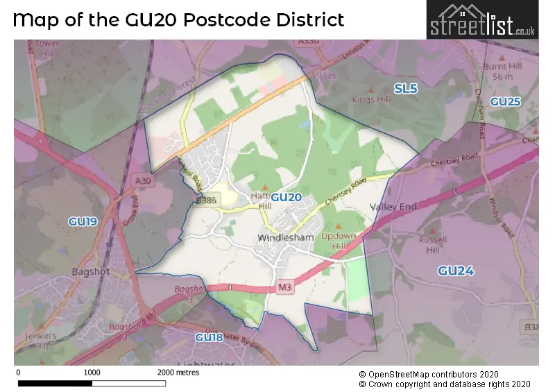
When it comes to local government, postal geography often disregards political borders. However, for a breakdown in the GU20 District: the district mostly encompasses the Surrey Heath District (B) (145 postcodes), and finally, the Woking District (B) area (4 postcodes).
Recent House Sales in GU20
| Date | Price | Address |
|---|---|---|
| 29/09/2023 | £665,000 | Thorndown Lane, Windlesham, GU20 6DD |
| 08/09/2023 | £250,000 | Fromow Gardens, Windlesham, GU20 6QN |
| 23/08/2023 | £600,000 | Kings Lane, Windlesham, GU20 6HR |
| 10/08/2023 | £880,000 | Snows Ride, Windlesham, GU20 6LA |
| 22/06/2023 | £785,000 | Cooper Road, Windlesham, GU20 6EA |
| 16/06/2023 | £120,000 | Fromow Gardens, Windlesham, GU20 6QN |
| 15/06/2023 | £357,000 | Windmill Field, Windlesham, GU20 6QD |
| 08/06/2023 | £1,150,000 | Chertsey Road, Windlesham, GU20 6HZ |
| 01/06/2023 | £660,000 | Cooper Road, Windlesham, GU20 6EA |
| 01/06/2023 | £725,000 | Bosman Drive, Windlesham, GU20 6JW |
Weather Forecast for GU20
Press Button to Show Forecast for Bagshot
| Time Period | Icon | Description | Temperature | Rain Probability | Wind |
|---|---|---|---|---|---|
| 21:00 to 00:00 | Overcast | 8.0°C (feels like 6.0°C) | 14.00% | ESE 7 mph |
Press Button to Show Forecast for Bagshot
| Time Period | Icon | Description | Temperature | Rain Probability | Wind |
|---|---|---|---|---|---|
| 00:00 to 03:00 | Cloudy | 7.0°C (feels like 5.0°C) | 55.00% | E 7 mph | |
| 03:00 to 06:00 | Light rain | 6.0°C (feels like 4.0°C) | 54.00% | ENE 9 mph | |
| 06:00 to 09:00 | Overcast | 6.0°C (feels like 3.0°C) | 23.00% | NE 9 mph | |
| 09:00 to 12:00 | Overcast | 7.0°C (feels like 5.0°C) | 17.00% | ENE 9 mph | |
| 12:00 to 15:00 | Cloudy | 10.0°C (feels like 9.0°C) | 12.00% | ENE 7 mph | |
| 15:00 to 18:00 | Cloudy | 12.0°C (feels like 10.0°C) | 15.00% | NE 7 mph | |
| 18:00 to 21:00 | Light rain | 11.0°C (feels like 9.0°C) | 59.00% | NE 9 mph | |
| 21:00 to 00:00 | Heavy rain | 9.0°C (feels like 7.0°C) | 85.00% | NNE 9 mph |
Press Button to Show Forecast for Bagshot
| Time Period | Icon | Description | Temperature | Rain Probability | Wind |
|---|---|---|---|---|---|
| 00:00 to 03:00 | Heavy rain | 8.0°C (feels like 6.0°C) | 90.00% | NNE 11 mph | |
| 03:00 to 06:00 | Heavy rain | 8.0°C (feels like 5.0°C) | 88.00% | NNE 9 mph | |
| 06:00 to 09:00 | Heavy rain | 7.0°C (feels like 5.0°C) | 89.00% | N 9 mph | |
| 09:00 to 12:00 | Heavy rain | 8.0°C (feels like 5.0°C) | 82.00% | WNW 9 mph | |
| 12:00 to 15:00 | Light rain | 9.0°C (feels like 7.0°C) | 56.00% | WNW 11 mph | |
| 15:00 to 18:00 | Cloudy | 10.0°C (feels like 8.0°C) | 16.00% | W 9 mph | |
| 18:00 to 21:00 | Cloudy | 10.0°C (feels like 8.0°C) | 7.00% | W 7 mph | |
| 21:00 to 00:00 | Partly cloudy (night) | 8.0°C (feels like 6.0°C) | 3.00% | SW 7 mph |
Press Button to Show Forecast for Bagshot
| Time Period | Icon | Description | Temperature | Rain Probability | Wind |
|---|---|---|---|---|---|
| 00:00 to 03:00 | Partly cloudy (night) | 6.0°C (feels like 5.0°C) | 2.00% | SW 7 mph | |
| 03:00 to 06:00 | Clear night | 5.0°C (feels like 3.0°C) | 1.00% | SSW 4 mph | |
| 06:00 to 09:00 | Sunny day | 6.0°C (feels like 5.0°C) | 1.00% | S 4 mph | |
| 09:00 to 12:00 | Cloudy | 11.0°C (feels like 9.0°C) | 4.00% | S 9 mph | |
| 12:00 to 15:00 | Cloudy | 13.0°C (feels like 11.0°C) | 7.00% | S 11 mph | |
| 15:00 to 18:00 | Partly cloudy (day) | 14.0°C (feels like 11.0°C) | 1.00% | S 11 mph | |
| 18:00 to 21:00 | Sunny day | 12.0°C (feels like 11.0°C) | 2.00% | S 9 mph | |
| 21:00 to 00:00 | Clear night | 9.0°C (feels like 7.0°C) | 3.00% | SSE 7 mph |
Press Button to Show Forecast for Bagshot
| Time Period | Icon | Description | Temperature | Rain Probability | Wind |
|---|---|---|---|---|---|
| 00:00 to 03:00 | Clear night | 8.0°C (feels like 6.0°C) | 3.00% | SE 7 mph | |
| 03:00 to 06:00 | Clear night | 8.0°C (feels like 6.0°C) | 4.00% | SE 7 mph | |
| 06:00 to 09:00 | Sunny day | 9.0°C (feels like 7.0°C) | 5.00% | SE 7 mph | |
| 09:00 to 12:00 | Partly cloudy (day) | 13.0°C (feels like 11.0°C) | 7.00% | SE 9 mph | |
| 12:00 to 15:00 | Partly cloudy (day) | 15.0°C (feels like 13.0°C) | 8.00% | SE 11 mph | |
| 15:00 to 18:00 | Partly cloudy (day) | 16.0°C (feels like 14.0°C) | 7.00% | SSE 9 mph | |
| 18:00 to 21:00 | Cloudy | 15.0°C (feels like 13.0°C) | 9.00% | SE 7 mph | |
| 21:00 to 00:00 | Partly cloudy (night) | 12.0°C (feels like 11.0°C) | 8.00% | SE 7 mph |
Where is the GU20 Postcode District?
The postcode district GU20 is located in the town of Windlesham. Windlesham is surrounded by several nearby towns, including Lightwater to the south (1.60 miles away), Bagshot to the west (1.84 miles away), Ascot to the north (2.53 miles away), Virginia Water to the northeast (4.08 miles away), Camberley to the southwest (4.17 miles away), Longcross to the east (4.30 miles away), Horsell to the southeast (4.81 miles away), and Bracknell to the northwest (4.96 miles away). Windlesham is approximately 24.73 miles away from the center of London.
The district is within the post town of WINDLESHAM.
The sector has postcodes within the nation of England.
The GU20 Postcode District is in the West Surrey region of Surrey, East and West Sussex within the South East (England).
Postcode Sectors within the GU20 District
| Postcode Sector | Delivery Office |
|---|---|
| GU20 6 | Windlesham Scale Payment Delivery Office |
| G | U | 2 | 0 | - | X | X | X |
| G | U | 2 | 0 | Space | Numeric | Letter | Letter |
Current Monthly Rental Prices
| # Bedrooms | Min Price | Max Price | Avg Price |
|---|---|---|---|
| 2 | £1,475 | £1,500 | £1,488 |
| 4 | £2,500 | £3,000 | £2,750 |
| 5 | £3,995 | £9,000 | £6,498 |
Current House Prices
| # Bedrooms | Min Price | Max Price | Avg Price |
|---|---|---|---|
| 1 | £260,000 | £260,000 | £260,000 |
| 2 | £325,000 | £325,000 | £325,000 |
| 3 | £450,000 | £1,250,000 | £748,000 |
| 4 | £699,950 | £1,599,950 | £903,741 |
| 5 | £550,000 | £1,750,000 | £953,571 |
| 7 | £4,500,000 | £4,500,000 | £4,500,000 |
| 10 | £3,500,000 | £3,500,000 | £3,500,000 |
Estate Agents who Operate in the GU20 District
| Logo | Name | Brand Name | Address | Contact Number | Total Properties |
|---|---|---|---|---|---|
 | Windlesham | Newton Rowe | The Old Dairy, 7 Updown Hill, Windlesham, GU20 6AF | 01276 740110 | 10 |
 | Sunningdale | Strutt & Parker | 40 Chobham Road, Sunningdale, Berkshire SL5 0DX | 01344 951855 | 5 |
 | Sunningdale | Hamptons Sales | 6, Broomhall Buildings, Chobham Road, Ascot, SL5 0DU | 01344 595071 | 3 |
 | Sunningdale & Ascot | Chatterton Rees Country Homes | Lavershot Barns London Road, Sunningdale, GU20 6LL | 01276 539525 | 2 |
 | Camberley | Jigsaw Estates | Jigsaw Estates Limited Park Street, Camberley, GU15 3PL | 01276 740137 | 2 |
| Type of Property | 2018 Average | 2018 Sales | 2017 Average | 2017 Sales | 2016 Average | 2016 Sales | 2015 Average | 2015 Sales |
|---|---|---|---|---|---|---|---|---|
| Detached | £960,803 | 33 | £1,301,678 | 36 | £946,747 | 43 | £685,311 | 41 |
| Semi-Detached | £577,059 | 17 | £647,188 | 8 | £513,495 | 22 | £455,475 | 20 |
| Terraced | £451,600 | 10 | £376,259 | 12 | £440,590 | 5 | £292,000 | 8 |
| Flats | £284,786 | 7 | £280,429 | 7 | £322,383 | 9 | £274,500 | 9 |