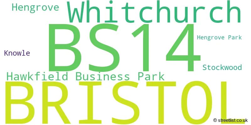
The BS14 postcode district is a postal district located in the BS Bristol postcode area with a population of 30,930 residents according to the 2021 England and Wales Census.
The area of the BS14 postcode district is 5.30 square miles which is 13.73 square kilometres or 3,392.67 acres.
Currently, the BS14 district has about 706 postcode units spread across 3 geographic postcode sectors.
Given that each sector allows for 400 unique postcode combinations, the district has a capacity of 1,200 postcodes. With 706 postcodes already in use, this leaves 494 units available.
The largest settlements in the BS14 postal code are BRISTOL and Whitchurch.
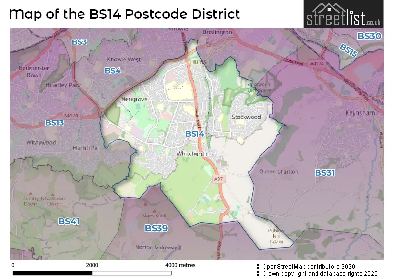
The BS14 Postcode shares a border with BS39 (Paulton, Pensford, Clutton), BS4 (BRISTOL, Brislington, Arnos Vale), BS41 (Long Ashton, Dundry), BS13 (BRISTOL, Bishopsworth) and BS31 (Keynsham, Saltford).
The primary settlement in the BS14 postcode district is Bristol, located in the county of Somerset, in England. The most significant post town in this district is also Bristol. Other notable settlements include Hawkfield Business Park, Hengrove Park, Whitchurch, and Stockwood.
For the district BS14, we have data on 3 postcode sectors. Here's a breakdown: The sector BS14 0, covers Bristol in Bristol. The sector BS14 0, covers Whitchurch in Somerset. The sector BS14 8, covers Bristol in Bristol. The sector BS14 9, covers Bristol in Bristol.

Map of the BS14 Postcode District
Explore the BS14 postcode district by using our free interactive map.
When it comes to local government, postal geography often disregards political borders. However, for a breakdown in the BS14 District: the district mostly encompasses the City of Bristol (B) (663 postcodes), and finally, the Bath and North East Somerset area (59 postcodes).
Weather Forecast for BS14
Press Button to Show Forecast for Stockwood
| Time Period | Icon | Description | Temperature | Rain Probability | Wind |
|---|---|---|---|---|---|
| 06:00 to 09:00 | Overcast | 5.0°C (feels like 2.0°C) | 18.00% | ENE 9 mph | |
| 09:00 to 12:00 | Overcast | 6.0°C (feels like 3.0°C) | 15.00% | ENE 11 mph | |
| 12:00 to 15:00 | Cloudy | 8.0°C (feels like 5.0°C) | 11.00% | ENE 11 mph | |
| 15:00 to 18:00 | Overcast | 10.0°C (feels like 7.0°C) | 12.00% | NE 11 mph | |
| 18:00 to 21:00 | Cloudy | 9.0°C (feels like 6.0°C) | 13.00% | NNE 11 mph | |
| 21:00 to 00:00 | Cloudy | 8.0°C (feels like 5.0°C) | 13.00% | NNE 11 mph |
Press Button to Show Forecast for Stockwood
| Time Period | Icon | Description | Temperature | Rain Probability | Wind |
|---|---|---|---|---|---|
| 00:00 to 03:00 | Light rain | 6.0°C (feels like 3.0°C) | 46.00% | NNE 11 mph | |
| 03:00 to 06:00 | Heavy rain | 6.0°C (feels like 2.0°C) | 77.00% | N 13 mph | |
| 06:00 to 09:00 | Heavy rain | 5.0°C (feels like 2.0°C) | 76.00% | N 11 mph | |
| 09:00 to 12:00 | Light rain | 7.0°C (feels like 4.0°C) | 51.00% | NNW 9 mph | |
| 12:00 to 15:00 | Cloudy | 9.0°C (feels like 7.0°C) | 16.00% | WNW 9 mph | |
| 15:00 to 18:00 | Cloudy | 11.0°C (feels like 8.0°C) | 12.00% | W 9 mph | |
| 18:00 to 21:00 | Sunny day | 10.0°C (feels like 8.0°C) | 4.00% | WSW 9 mph | |
| 21:00 to 00:00 | Clear night | 7.0°C (feels like 5.0°C) | 1.00% | WSW 7 mph |
Press Button to Show Forecast for Stockwood
| Time Period | Icon | Description | Temperature | Rain Probability | Wind |
|---|---|---|---|---|---|
| 00:00 to 03:00 | Clear night | 6.0°C (feels like 4.0°C) | 1.00% | SSW 7 mph | |
| 03:00 to 06:00 | Clear night | 5.0°C (feels like 3.0°C) | 2.00% | S 7 mph | |
| 06:00 to 09:00 | Sunny day | 6.0°C (feels like 4.0°C) | 2.00% | S 7 mph | |
| 09:00 to 12:00 | Cloudy | 11.0°C (feels like 8.0°C) | 6.00% | S 13 mph | |
| 12:00 to 15:00 | Cloudy | 13.0°C (feels like 10.0°C) | 7.00% | S 16 mph | |
| 15:00 to 18:00 | Cloudy | 13.0°C (feels like 10.0°C) | 7.00% | S 16 mph | |
| 18:00 to 21:00 | Sunny day | 12.0°C (feels like 10.0°C) | 4.00% | S 11 mph | |
| 21:00 to 00:00 | Clear night | 9.0°C (feels like 7.0°C) | 4.00% | SSE 11 mph |
Press Button to Show Forecast for Stockwood
| Time Period | Icon | Description | Temperature | Rain Probability | Wind |
|---|---|---|---|---|---|
| 00:00 to 03:00 | Cloudy | 9.0°C (feels like 6.0°C) | 7.00% | SE 9 mph | |
| 03:00 to 06:00 | Clear night | 8.0°C (feels like 6.0°C) | 4.00% | SE 9 mph | |
| 06:00 to 09:00 | Sunny day | 8.0°C (feels like 6.0°C) | 5.00% | SE 9 mph | |
| 09:00 to 12:00 | Partly cloudy (day) | 12.0°C (feels like 10.0°C) | 9.00% | SE 13 mph | |
| 12:00 to 15:00 | Partly cloudy (day) | 15.0°C (feels like 12.0°C) | 9.00% | SE 13 mph | |
| 15:00 to 18:00 | Cloudy | 15.0°C (feels like 12.0°C) | 16.00% | SE 11 mph | |
| 18:00 to 21:00 | Cloudy | 13.0°C (feels like 12.0°C) | 12.00% | SE 9 mph | |
| 21:00 to 00:00 | Clear night | 11.0°C (feels like 10.0°C) | 6.00% | SE 7 mph |
Where is the BS14 Postcode District?
The BS14 postcode district is located in Bristol. Bristol is located approximately 105.21 miles away from the center of London. It is surrounded by nearby towns such as Bath, Radstock, Clevedon, Cheddar, and Badminton, which are located in the East, South East, West, South West, and North East directions, respectively.
The district is within the post town of BRISTOL.
The sector has postcodes within the nation of England.
The BS14 Postcode District is covers the following regions.
- Bristol, City of - Gloucestershire, Wiltshire and Bath/Bristol area - South West (England)
- Bath and North East Somerset, North Somerset and South Gloucestershire - Gloucestershire, Wiltshire and Bath/Bristol area - South West (England)
| Postcode Sector | Delivery Office |
|---|---|
| BS14 0 | Bristol South East Delivery Office |
| BS14 8 | Bristol South East Delivery Office |
| BS14 9 | Bristol South East Delivery Office |
| B | S | 1 | 4 | - | X | X | X |
| B | S | 1 | 4 | Space | Numeric | Letter | Letter |
Current Monthly Rental Prices
| # Bedrooms | Min Price | Max Price | Avg Price |
|---|---|---|---|
| 2 | £1,150 | £1,400 | £1,275 |
| 3 | £1,300 | £1,650 | £1,475 |
| 4 | £1,800 | £6,000 | £3,300 |
Current House Prices
| # Bedrooms | Min Price | Max Price | Avg Price |
|---|---|---|---|
| 3 | £450,000 | £1,250,000 | £601,000 |
| 4 | £440,000 | £1,695,000 | £681,000 |
| 5 | £450,000 | £950,000 | £597,500 |
| 6 | £1,450,000 | £1,450,000 | £1,450,000 |
Estate Agents who Operate in the BS14 District
| Logo | Name | Brand Name | Address | Contact Number | Total Properties |
|---|---|---|---|---|---|
 | Whitchurch & Country Properties | Hunters | 91 Bristol Road, Whitchurch, Bristol, BS14 0PS | 01275 402752 | 23 |
 | Whitchurch | MG Estate Agents Ltd | 101 - 103 Bristol Road, Whitchurch, Bristol, BS14 0PS | 01275 402929 | 22 |
 | Keynsham | Eveleighs | 45 Courtenay Road, Keynsham, Bristol, BS31 1JU | 0117 463 0368 | 21 |
 | Bristol | Greenwoods Property Centre | 148a Wells Road, Totterdown, Bristol, BS4 2AG | 0117 977 7672 | 17 |
 | Whitchurch | Stephen Maggs Estate Agents | 107 Bristol Road, Whitchurch, Bristol, BS14 0PU | 01275 402857 | 8 |
| Type of Property | 2018 Average | 2018 Sales | 2017 Average | 2017 Sales | 2016 Average | 2016 Sales | 2015 Average | 2015 Sales |
|---|---|---|---|---|---|---|---|---|
| Detached | £373,729 | 71 | £365,570 | 39 | £312,678 | 36 | £327,167 | 58 |
| Semi-Detached | £262,444 | 224 | £260,611 | 182 | £247,070 | 168 | £219,021 | 179 |
| Terraced | £222,512 | 179 | £221,579 | 188 | £209,892 | 166 | £178,557 | 170 |
| Flats | £133,301 | 51 | £134,574 | 57 | £125,567 | 57 | £113,909 | 50 |