The BS26 postcode district is a postal district located in the BS Bristol postcode area with a population of 4,941 residents according to the 2021 England and Wales Census.
The area of the BS26 postcode district is 18.80 square miles which is 48.69 square kilometres or 12,031.16 acres.
Currently, the BS26 district has about 224 postcode units spread across 1 geographic postcode sectors.
Given that each sector allows for 400 unique postcode combinations, the district has a capacity of 400 postcodes. With 224 postcodes already in use, this leaves 176 units available.
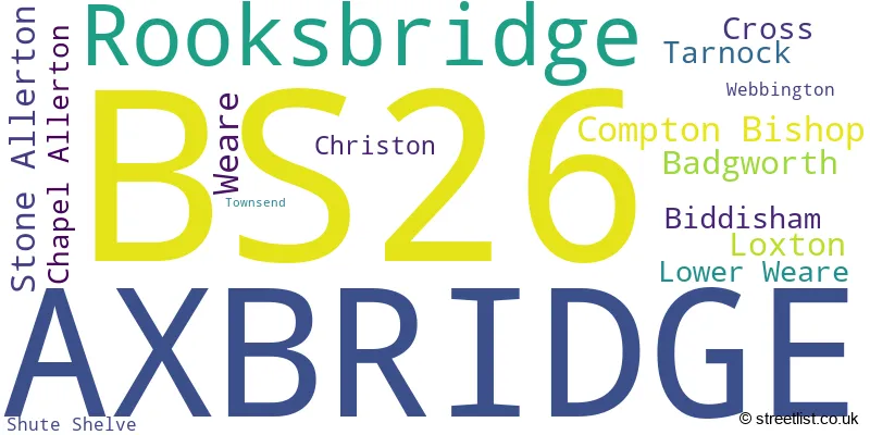
The largest settlement in the BS26 postal code is AXBRIDGE followed by Rooksbridge, and Weare.
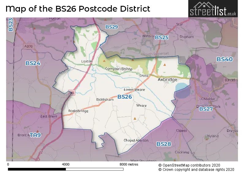
The BS26 Postcode shares a border with BS24 (WESTON-SUPER-MARE, Locking, West Wick), BS25 (WINSCOMBE, Sandford, Shipham) and TA9 (HIGHBRIDGE, Mark, West Huntspill).
The primary settlement in the BS26 postcode district is Axbridge, located in the county of Somerset, England. Other significant settlements in this area include Badgworth, Biddisham, Chapel Allerton, Christon, Compton Bishop, Cross, Lower Weare, Loxton, Rooksbridge, Stone Allerton, Tarnock, Weare, and Webbington. The most significant post town is Axbridge.
For the district BS26, we have data on 1 postcode sectors. Here's a breakdown: The sector BS26 2, covers Axbridge and Rooksbridge in Somerset.
BS26 Postcode Sectors

Map of the BS26 Postcode District
Explore the BS26 postcode district by using our free interactive map.
When it comes to local government, postal geography often disregards political borders. However, for a breakdown in the BS26 District: the district mostly encompasses the Somerset (209 postcodes), and finally, the North Somerset area (17 postcodes).
Weather Forecast for BS26
Press Button to Show Forecast for Avon Ski Centre
| Time Period | Icon | Description | Temperature | Rain Probability | Wind |
|---|---|---|---|---|---|
| 03:00 to 06:00 | Overcast | 6.0°C (feels like 2.0°C) | 53.00% | ENE 11 mph | |
| 06:00 to 09:00 | Overcast | 5.0°C (feels like 2.0°C) | 15.00% | ENE 11 mph | |
| 09:00 to 12:00 | Cloudy | 7.0°C (feels like 3.0°C) | 11.00% | ENE 13 mph | |
| 12:00 to 15:00 | Cloudy | 9.0°C (feels like 6.0°C) | 7.00% | ENE 11 mph | |
| 15:00 to 18:00 | Cloudy | 10.0°C (feels like 7.0°C) | 14.00% | NE 13 mph | |
| 18:00 to 21:00 | Cloudy | 9.0°C (feels like 6.0°C) | 10.00% | NE 13 mph | |
| 21:00 to 00:00 | Cloudy | 7.0°C (feels like 4.0°C) | 13.00% | NNE 13 mph |
Press Button to Show Forecast for Avon Ski Centre
| Time Period | Icon | Description | Temperature | Rain Probability | Wind |
|---|---|---|---|---|---|
| 00:00 to 03:00 | Light rain | 6.0°C (feels like 3.0°C) | 48.00% | NNE 13 mph | |
| 03:00 to 06:00 | Heavy rain | 6.0°C (feels like 2.0°C) | 79.00% | N 13 mph | |
| 06:00 to 09:00 | Heavy rain | 5.0°C (feels like 2.0°C) | 79.00% | N 11 mph | |
| 09:00 to 12:00 | Light rain | 7.0°C (feels like 4.0°C) | 52.00% | NNW 11 mph | |
| 12:00 to 15:00 | Cloudy | 9.0°C (feels like 7.0°C) | 16.00% | WNW 11 mph | |
| 15:00 to 18:00 | Partly cloudy (day) | 10.0°C (feels like 8.0°C) | 8.00% | W 11 mph | |
| 18:00 to 21:00 | Sunny day | 9.0°C (feels like 7.0°C) | 3.00% | WSW 11 mph | |
| 21:00 to 00:00 | Clear night | 6.0°C (feels like 4.0°C) | 1.00% | WSW 7 mph |
Press Button to Show Forecast for Avon Ski Centre
| Time Period | Icon | Description | Temperature | Rain Probability | Wind |
|---|---|---|---|---|---|
| 00:00 to 03:00 | Clear night | 4.0°C (feels like 1.0°C) | 0.00% | SSW 7 mph | |
| 03:00 to 06:00 | Clear night | 3.0°C (feels like 0.0°C) | 1.00% | SSE 7 mph | |
| 06:00 to 09:00 | Partly cloudy (day) | 6.0°C (feels like 3.0°C) | 2.00% | SSE 9 mph | |
| 09:00 to 12:00 | Cloudy | 11.0°C (feels like 8.0°C) | 6.00% | S 13 mph | |
| 12:00 to 15:00 | Cloudy | 12.0°C (feels like 9.0°C) | 7.00% | S 16 mph | |
| 15:00 to 18:00 | Cloudy | 12.0°C (feels like 9.0°C) | 7.00% | S 16 mph | |
| 18:00 to 21:00 | Partly cloudy (day) | 11.0°C (feels like 9.0°C) | 4.00% | S 13 mph | |
| 21:00 to 00:00 | Clear night | 9.0°C (feels like 6.0°C) | 4.00% | SE 11 mph |
Press Button to Show Forecast for Avon Ski Centre
| Time Period | Icon | Description | Temperature | Rain Probability | Wind |
|---|---|---|---|---|---|
| 00:00 to 03:00 | Partly cloudy (night) | 8.0°C (feels like 6.0°C) | 4.00% | SE 11 mph | |
| 03:00 to 06:00 | Clear night | 8.0°C (feels like 5.0°C) | 5.00% | SE 11 mph | |
| 06:00 to 09:00 | Sunny day | 8.0°C (feels like 6.0°C) | 6.00% | SE 11 mph | |
| 09:00 to 12:00 | Partly cloudy (day) | 12.0°C (feels like 10.0°C) | 10.00% | SE 13 mph | |
| 12:00 to 15:00 | Partly cloudy (day) | 14.0°C (feels like 11.0°C) | 12.00% | SE 16 mph | |
| 15:00 to 18:00 | Cloudy | 14.0°C (feels like 11.0°C) | 31.00% | SE 13 mph | |
| 18:00 to 21:00 | Partly cloudy (day) | 13.0°C (feels like 11.0°C) | 8.00% | SE 9 mph | |
| 21:00 to 00:00 | Clear night | 10.0°C (feels like 8.0°C) | 6.00% | ESE 7 mph |
Where is the BS26 Postcode District?
The postcode district BS26 is located in the town of Axbridge. It is surrounded by several nearby towns including Winscombe to the North East (2.67 miles away), Banwell to the North (3.74 miles away), Cheddar to the East (3.76 miles away), Wedmore to the South East (5.16 miles away), Highbridge to the South West (5.94 miles away), and Weston-super-Mare to the North West (6.01 miles away). Additionally, the district is approximately 119.48 miles away from the center of London.
The district is within the post town of AXBRIDGE.
The sector has postcodes within the nation of England.
The BS26 Postcode District is covers the following regions.
- Somerset - Dorset and Somerset - South West (England)
- Bath and North East Somerset, North Somerset and South Gloucestershire - Gloucestershire, Wiltshire and Bath/Bristol area - South West (England)
Postcode Sectors within the BS26 District
| Postcode Sector | Delivery Office |
|---|---|
| BS26 2 | Axbridge Scale Payment Delivery Office |
| B | S | 2 | 6 | - | X | X | X |
| B | S | 2 | 6 | Space | Numeric | Letter | Letter |
Current Monthly Rental Prices
| # Bedrooms | Min Price | Max Price | Avg Price |
|---|
Current House Prices
| # Bedrooms | Min Price | Max Price | Avg Price |
|---|---|---|---|
| £695,000 | £1,800,000 | £1,247,500 | |
| 3 | £650,000 | £1,200,000 | £863,000 |
| 4 | £645,000 | £950,000 | £854,000 |
| 5 | £650,000 | £1,750,000 | £882,500 |
| 6 | £950,000 | £1,525,000 | £1,237,500 |
| 8 | £2,250,000 | £2,250,000 | £2,250,000 |
Estate Agents who Operate in the BS26 District
| Logo | Name | Brand Name | Address | Contact Number | Total Properties |
|---|---|---|---|---|---|
 | Cheddar | Cooper & Tanner | 2 Saxon Court Union Street, Cheddar, BS27 3NA | 01934 314984 | 11 |
 | Cheddar | Laurel & Wylde | 2 Bath Street, Cheddar, BS27 3AA | 01934 315048 | 9 |
 | Bristol | Knight Frank | 1 The Mall, Clifton, Bristol BS8 4DP | 0117 463 8684 | 6 |
 | Wells | Fine & Country Wells and Chew Valley | Melbourne House, 36 Chamberlain Street, Wells, BA5 2PJ | 01761 258932 | 4 |
 | Burnham-On-Sea | Greenslade Taylor Hunt | 44 High Street, Burnham-On-Sea, TA8 1AZ | 01278 552643 | 4 |
| Type of Property | 2018 Average | 2018 Sales | 2017 Average | 2017 Sales | 2016 Average | 2016 Sales | 2015 Average | 2015 Sales |
|---|---|---|---|---|---|---|---|---|
| Detached | £473,267 | 30 | £449,245 | 38 | £398,294 | 25 | £388,570 | 35 |
| Semi-Detached | £235,822 | 11 | £317,167 | 12 | £315,865 | 13 | £242,333 | 18 |
| Terraced | £301,143 | 7 | £274,963 | 20 | £284,782 | 23 | £246,018 | 11 |
| Flats | £139,333 | 3 | £104,750 | 4 | £129,556 | 9 | £139,378 | 9 |