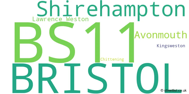
The BS11 postcode district is a postal district located in the BS Bristol postcode area with a population of 19,089 residents according to the 2021 England and Wales Census.
The area of the BS11 postcode district is 6.68 square miles which is 17.30 square kilometres or 4,275.56 acres.
Currently, the BS11 district has about 563 postcode units spread across 3 geographic postcode sectors.
Given that each sector allows for 400 unique postcode combinations, the district has a capacity of 1,200 postcodes. With 563 postcodes already in use, this leaves 637 units available.
The largest settlement in the BS11 postal code is BRISTOL followed by Shirehampton, and Avonmouth.
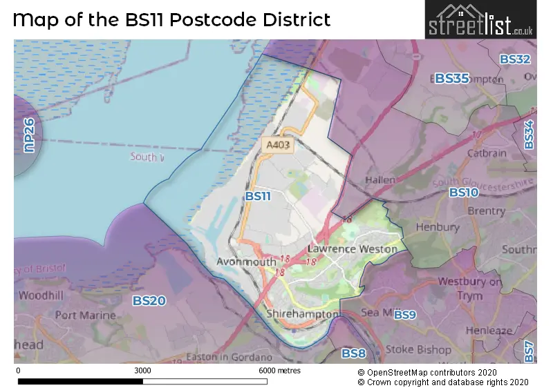
The postcode area has a boundary with The Bristol Channel.
The BS11 Postcode shares a border with BS9 (BRISTOL, Westbury-on-Trym, Stoke Bishop) and BS10 (BRISTOL, Westbury-on-Trym, Henbury).
In the BS11 postcode district in Bristol, the primary settlement is Bristol, which has the highest count. Other significant settlements include Chittening, Kingsweston, Lawrence Weston, and Shirehampton. The county is Bristol, which is located in England. The most significant post town is also Bristol.
For the district BS11, we have data on 4 postcode sectors. Here's a breakdown: The sector BS11 0, covers Bristol in Bristol. The sector BS11 1 is non-geographic. It's often designated for PO Boxes, large organisations, or special services. The sector BS11 8, covers Bristol in Bristol. The sector BS11 9, covers Bristol and Avonmouth and Shirehampton in Bristol.

Map of the BS11 Postcode District
Explore the BS11 postcode district by using our free interactive map.
When it comes to local government, postal geography often disregards political borders. However, for a breakdown in the BS11 District: the district mostly encompasses the City of Bristol (B) area with a total of 574 postcodes.
Where is the BS11 Postcode District?
The postcode district of BS11 is located in Bristol. It is in close proximity to nearby towns, including Caldicot to the North West (6.93 miles away), Chepstow to the North (8.51 miles away), Clevedon to the South West (8.54 miles away), Bath to the South East (15.46 miles away), and Badminton to the East (16.08 miles away). Moreover, the distance from BS11 to the center of London is approximately 110.01 miles.
The district is within the post town of BRISTOL.
The sector has postcodes within the nation of England.
The BS11 Postcode District is in the Bristol, City of region of Gloucestershire, Wiltshire and Bath/Bristol area within the South West (England).
Weather Forecast for BS11
Press Button to Show Forecast for Avonmouth
| Time Period | Icon | Description | Temperature | Rain Probability | Wind |
|---|---|---|---|---|---|
| 15:00 to 18:00 | Heavy rain shower (day) | 21.0°C (feels like 20.0°C) | 60.00% | SW 7 mph | |
| 18:00 to 21:00 | Partly cloudy (day) | 19.0°C (feels like 18.0°C) | 31.00% | WSW 7 mph | |
| 21:00 to 00:00 | Partly cloudy (night) | 14.0°C (feels like 13.0°C) | 1.00% | SW 9 mph |
Press Button to Show Forecast for Avonmouth
| Time Period | Icon | Description | Temperature | Rain Probability | Wind |
|---|---|---|---|---|---|
| 00:00 to 03:00 | Cloudy | 13.0°C (feels like 11.0°C) | 4.00% | SW 9 mph | |
| 03:00 to 06:00 | Overcast | 12.0°C (feels like 12.0°C) | 9.00% | SW 4 mph | |
| 06:00 to 09:00 | Cloudy | 13.0°C (feels like 12.0°C) | 8.00% | S 9 mph | |
| 09:00 to 12:00 | Cloudy | 15.0°C (feels like 13.0°C) | 5.00% | S 11 mph | |
| 12:00 to 15:00 | Cloudy | 17.0°C (feels like 14.0°C) | 9.00% | SSE 16 mph | |
| 15:00 to 18:00 | Light rain | 16.0°C (feels like 13.0°C) | 42.00% | SSE 16 mph | |
| 18:00 to 21:00 | Light rain | 15.0°C (feels like 13.0°C) | 54.00% | SE 13 mph | |
| 21:00 to 00:00 | Light rain | 15.0°C (feels like 13.0°C) | 62.00% | SE 11 mph |
Press Button to Show Forecast for Avonmouth
| Time Period | Icon | Description | Temperature | Rain Probability | Wind |
|---|---|---|---|---|---|
| 00:00 to 03:00 | Heavy rain | 14.0°C (feels like 13.0°C) | 85.00% | SE 9 mph | |
| 03:00 to 06:00 | Light rain | 13.0°C (feels like 12.0°C) | 56.00% | SSE 7 mph | |
| 06:00 to 09:00 | Light rain | 13.0°C (feels like 12.0°C) | 58.00% | SSE 7 mph | |
| 09:00 to 12:00 | Light rain | 14.0°C (feels like 13.0°C) | 59.00% | SSE 9 mph | |
| 12:00 to 15:00 | Cloudy | 16.0°C (feels like 13.0°C) | 22.00% | SSE 11 mph | |
| 15:00 to 18:00 | Cloudy | 17.0°C (feels like 14.0°C) | 17.00% | SSE 13 mph | |
| 18:00 to 21:00 | Cloudy | 16.0°C (feels like 14.0°C) | 14.00% | SSE 11 mph | |
| 21:00 to 00:00 | Cloudy | 14.0°C (feels like 13.0°C) | 8.00% | SE 9 mph |
Press Button to Show Forecast for Avonmouth
| Time Period | Icon | Description | Temperature | Rain Probability | Wind |
|---|---|---|---|---|---|
| 00:00 to 03:00 | Clear night | 13.0°C (feels like 12.0°C) | 5.00% | SE 9 mph | |
| 03:00 to 06:00 | Partly cloudy (night) | 12.0°C (feels like 11.0°C) | 4.00% | ESE 9 mph | |
| 06:00 to 09:00 | Sunny day | 13.0°C (feels like 11.0°C) | 4.00% | ESE 11 mph | |
| 09:00 to 12:00 | Cloudy | 15.0°C (feels like 13.0°C) | 14.00% | SE 11 mph | |
| 12:00 to 15:00 | Partly cloudy (day) | 17.0°C (feels like 14.0°C) | 13.00% | SE 13 mph | |
| 15:00 to 18:00 | Partly cloudy (day) | 17.0°C (feels like 15.0°C) | 10.00% | SSE 11 mph | |
| 18:00 to 21:00 | Sunny day | 17.0°C (feels like 15.0°C) | 8.00% | SSE 9 mph | |
| 21:00 to 00:00 | Clear night | 14.0°C (feels like 13.0°C) | 3.00% | SE 7 mph |
Press Button to Show Forecast for Avonmouth
| Time Period | Icon | Description | Temperature | Rain Probability | Wind |
|---|---|---|---|---|---|
| 00:00 to 03:00 | Clear night | 12.0°C (feels like 12.0°C) | 2.00% | ESE 4 mph | |
| 03:00 to 06:00 | Clear night | 11.0°C (feels like 10.0°C) | 1.00% | E 4 mph | |
| 06:00 to 09:00 | Sunny day | 12.0°C (feels like 11.0°C) | 2.00% | ENE 4 mph | |
| 09:00 to 12:00 | Sunny day | 15.0°C (feels like 15.0°C) | 5.00% | ESE 7 mph | |
| 12:00 to 15:00 | Partly cloudy (day) | 17.0°C (feels like 17.0°C) | 16.00% | S 7 mph | |
| 15:00 to 18:00 | Light rain shower (day) | 17.0°C (feels like 16.0°C) | 39.00% | SSE 7 mph | |
| 18:00 to 21:00 | Cloudy | 17.0°C (feels like 16.0°C) | 16.00% | WSW 7 mph | |
| 21:00 to 00:00 | Cloudy | 15.0°C (feels like 14.0°C) | 9.00% | WNW 4 mph |
| Postcode Sector | Delivery Office |
|---|---|
| BS11 0 | Avonmouth Delivery Office |
| BS11 8 | Avonmouth Delivery Office |
| BS11 9 | Avonmouth Delivery Office |
| B | S | 1 | 1 | - | X | X | X |
| B | S | 1 | 1 | Space | Numeric | Letter | Letter |
Current Monthly Rental Prices
| # Bedrooms | Min Price | Max Price | Avg Price |
|---|---|---|---|
| £765 | £765 | £765 | |
| 1 | £550 | £758 | £698 |
| 2 | £1,000 | £1,000 | £1,000 |
| 3 | £1,500 | £2,199 | £1,733 |
| 4 | £2,200 | £2,495 | £2,348 |
Current House Prices
| # Bedrooms | Min Price | Max Price | Avg Price |
|---|---|---|---|
| 2 | £365,000 | £439,950 | £406,650 |
| 3 | £350,000 | £450,000 | £384,615 |
| 4 | £370,000 | £745,000 | £563,571 |
| 7 | £685,000 | £685,000 | £685,000 |
| 8 | £730,000 | £730,000 | £730,000 |
Estate Agents who Operate in the BS11 District
| Logo | Name | Brand Name | Address | Contact Number | Total Properties |
|---|---|---|---|---|---|
 | Shirehampton | Ocean | 14-16 High Street, Shirehampton, Bristol, BS11 0DP | 0117 463 0082 | 26 |
 | Shirehampton | Goodman & Lilley | 9 High Street, Shirehampton, Bristol, BS11 0DT | 0117 463 0290 | 22 |
 | London | HYBR | 101 Blenheim Crescent, London, W11 2EQ | 020 3966 4594 | 5 |
 | London | OpenRent | 39 Great Windmill Street London W1D 7LX | 020 3322 3265 | 2 |
 | covering Bristol | Purplebricks | Suite 7 First Floor Cranmore Drive Shirley Solihull B90 4RZ | 020 3834 8691 | 2 |
Yearly House Price Averages for the BS11 Postcode District
| Type of Property | 2018 Average | 2018 Sales | 2017 Average | 2017 Sales | 2016 Average | 2016 Sales | 2015 Average | 2015 Sales |
|---|---|---|---|---|---|---|---|---|
| Detached | £397,450 | 10 | £343,353 | 17 | £388,800 | 10 | £295,442 | 18 |
| Semi-Detached | £234,867 | 85 | £221,582 | 83 | £206,952 | 83 | £182,505 | 85 |
| Terraced | £220,976 | 112 | £214,680 | 105 | £210,404 | 127 | £194,100 | 136 |
| Flats | £160,084 | 44 | £147,444 | 37 | £134,283 | 47 | £117,998 | 31 |