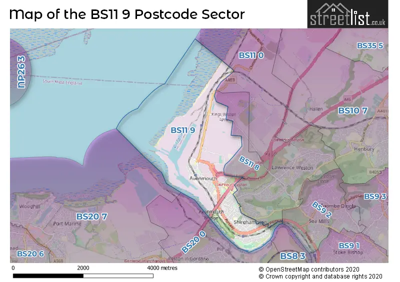
The BS11 9 postcode sector stands on the Bristol and Gloucestershire border.
Did you know? According to the 2021 Census, the BS11 9 postcode sector is home to a bustling 8,477 residents!
Given that each sector allows for 400 unique postcode combinations. Letters C, I, K, M, O and V are not allowed in the last two letters of a postcode. With 256 postcodes already in use, this leaves 144 units available.
The largest settlement in the BS11 9 postal code is BRISTOL followed by Avonmouth, and Shirehampton.
The BS11 9 Postcode shares a border with BS9 2 (BRISTOL, Coombe Dingle, Sea Mills), BS20 0 (Pill, Easton-in-Gordano) and BS11 0 (BRISTOL, Shirehampton, Chittening).
The sector is within the post town of BRISTOL.
BS11 9 is a postcode sector within the BS11 postcode district which is within the BS Bristol postcode area.
The Royal Mail delivery office for the BS11 9 postal sector is the Avonmouth Delivery Office.
The area of the BS11 9 postcode sector is 2.63 square miles which is 6.80 square kilometres or 1,680.98 square acres.
The BS11 9 postcode sector is crossed by the M5 motorway.
The BS11 9 postcode sector is crossed by the A4 Major A road.

Map of the BS11 9 Postcode Sector
Explore the BS11 9 postcode sector by using our free interactive map.
| B | S | 1 | 1 | - | 9 | X | X |
| B | S | 1 | 1 | Space | 9 | Letter | Letter |
Official List of Streets
BRISTOL (73 Streets)
Avonmouth (23 Streets)
Shirehampton (10 Streets)
Unofficial Streets or Alternative Spellings
BRISTOL
LOWER HIGH STREET PENLEA COURT SMOKE LANEShirehampton
PARK ROAD PRIORY GARDENS ANTONA COURT AVONBRIDGE TRADING ESTATE BOUNDARY ROAD EVELYN LANE FIRE STATION LANE LAMPLIGHTERS QUAY LAWRENCE WESTON GREENWAY MYRTLE COTTAGE NEALE WAY PORTWAY ROUNDABOUT SAINT BERNARDS ROAD SAINT MARYS ROAD SAINT MARYS WALK SAINT TECLA CLOSE ST BRENDANS ROUNDABOUT ST GEORGES INDUSTRIAL ESTATE TYNINGS FIELD WAVERLEY ROAD YARA ESTATE ZINC ROADKingsweston
KINGS WESTON LANEWeather Forecast for BS11 9
Press Button to Show Forecast for Avonmouth
| Time Period | Icon | Description | Temperature | Rain Probability | Wind |
|---|---|---|---|---|---|
| 06:00 to 09:00 | Sunny day | 9.0°C (feels like 8.0°C) | 2.00% | SSE 4 mph | |
| 09:00 to 12:00 | Partly cloudy (day) | 13.0°C (feels like 11.0°C) | 4.00% | S 9 mph | |
| 12:00 to 15:00 | Partly cloudy (day) | 15.0°C (feels like 13.0°C) | 7.00% | S 11 mph | |
| 15:00 to 18:00 | Cloudy | 16.0°C (feels like 13.0°C) | 10.00% | S 11 mph | |
| 18:00 to 21:00 | Cloudy | 15.0°C (feels like 13.0°C) | 23.00% | S 11 mph | |
| 21:00 to 00:00 | Cloudy | 13.0°C (feels like 11.0°C) | 20.00% | S 9 mph |
Press Button to Show Forecast for Avonmouth
| Time Period | Icon | Description | Temperature | Rain Probability | Wind |
|---|---|---|---|---|---|
| 00:00 to 03:00 | Cloudy | 11.0°C (feels like 10.0°C) | 8.00% | S 9 mph | |
| 03:00 to 06:00 | Cloudy | 11.0°C (feels like 10.0°C) | 9.00% | S 7 mph | |
| 06:00 to 09:00 | Overcast | 11.0°C (feels like 10.0°C) | 25.00% | SSE 7 mph | |
| 09:00 to 12:00 | Cloudy | 13.0°C (feels like 12.0°C) | 11.00% | S 9 mph | |
| 12:00 to 15:00 | Cloudy | 15.0°C (feels like 14.0°C) | 12.00% | SSE 9 mph | |
| 15:00 to 18:00 | Cloudy | 16.0°C (feels like 14.0°C) | 10.00% | SSE 9 mph | |
| 18:00 to 21:00 | Cloudy | 15.0°C (feels like 14.0°C) | 10.00% | SSW 9 mph | |
| 21:00 to 00:00 | Partly cloudy (night) | 13.0°C (feels like 12.0°C) | 7.00% | S 9 mph |
Schools and Places of Education Within the BS11 9 Postcode Sector
Avonmouth Church of England Primary School and Nursery
Voluntary controlled school
Catherine Street, Bristol, , BS11 9LG
Head: Mrs Jessica Peach
Ofsted Rating: Good
Inspection: 2023-02-22 (437 days ago)
Website: Visit Avonmouth Church of England Primary School and Nursery Website
Phone: 01179030280
Number of Pupils: 211
Nova Primary School
Community school
Barracks Lane, Bristol, , BS11 9NG
Head: Mrs Anna Morris
Ofsted Rating: Good
Inspection: 2022-07-06 (668 days ago)
Website: Visit Nova Primary School Website
Phone: 01179030446
Number of Pupils: 283
Shirehampton Primary School
Community school
St Mary's Walk, Bristol, , BS11 9RR
Head: Louisa Munton
Ofsted Rating: Good
Inspection: 2023-04-19 (381 days ago)
Website: Visit Shirehampton Primary School Website
Phone: 01179031447
Number of Pupils: 521
House Prices in the BS11 9 Postcode Sector
| Type of Property | 2018 Average | 2018 Sales | 2017 Average | 2017 Sales | 2016 Average | 2016 Sales | 2015 Average | 2015 Sales |
|---|---|---|---|---|---|---|---|---|
| Detached | £374,875 | 4 | £227,400 | 5 | £391,625 | 4 | £268,500 | 4 |
| Semi-Detached | £247,491 | 49 | £235,193 | 36 | £222,605 | 49 | £189,450 | 39 |
| Terraced | £225,228 | 73 | £218,341 | 59 | £214,472 | 73 | £193,691 | 78 |
| Flats | £160,797 | 15 | £146,497 | 17 | £124,773 | 20 | £119,184 | 16 |
Important Postcodes BS11 9 in the Postcode Sector
BS11 9BT is the postcode for Burlingtown Juice Ltd, Berth Three Oil Basin, Royal Edward Dock
BS11 9DJ is the postcode for Avon Fire & Rescue Service, Nova Way, Nova Way Technical Centre, Avon Fire & Rescue Service, Nova Way, Avon Fire And Rescue Technical Centre, Nova Way, Avonmouth, and Avon Fire & Rescue Technical Centre, Nova Way
BS11 9EN is the postcode for Bristol City Council, Avonmouth Library, 257 Avonmouth Road
BS11 9EY is the postcode for Royal Mail, Avonmouth Delivery Office, St. Brendans Way
BS11 9FB is the postcode for St. Brendans Court, Bristow Broadway, Island Trade Park
BS11 9HQ is the postcode for Avonmouth Fire Station, Avon Fire & Rescue Service, St. Andrews Road, Avon Fire & Rescue Service, Avonmouth Fire Station, St. Andrews Road, and Avonmouth Fire Station, St Andrews Road
BS11 9JJ is the postcode for Avonmouth Medical Centre, Collins Street
BS11 9LG is the postcode for Avonmouth C of E School, Catherine Street, and Avonmouth C of E School, Catherine Street, Avonmouth
BS11 9NG is the postcode for Nova Primary School, Barracks Lane
BS11 9RR is the postcode for Shirehampton Primary School, St. Marys Walk
BS11 9SB is the postcode for Shirehampton Health Centre, Pembroke Road, and Shirehampton Health Centre, Pembroke Road, Shirehampton
BS11 9TU is the postcode for St. Bernards RC Primary School, Station Road
BS11 9TX is the postcode for Shirehampton Public Hall, 32 Station Road
BS11 9YS is the postcode for M A N Bristol, Third Way
| The BS11 9 Sector is within these Local Authorities |
|
|---|---|
| The BS11 9 Sector is within these Counties |
|
| The BS11 9 Sector is within these Water Company Areas |
|