
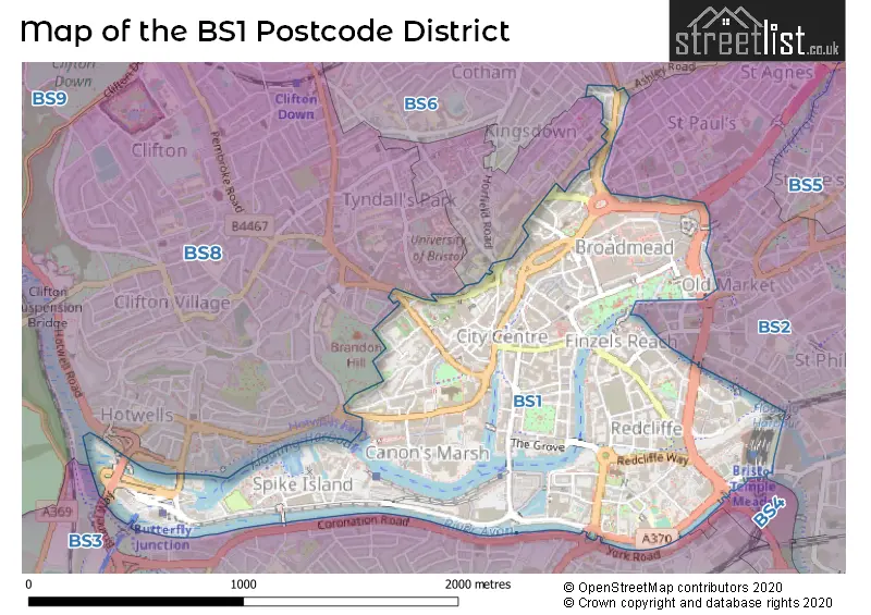
Map of the Postcode District
Explore the postcode district by using our interactive map.
Circles represent recorded crime; the larger the circle, the higher the crime rates.
Your support helps keep this site running!
If you enjoy using this website, consider buying me a coffee to help cover hosting costs.
The postcode district located in the BS Bristol postal area , BS1 has a population of 18,751 residents according to the 2021 England and Wales Census.
The area of the district is 1.04 square miles (2.68 square kilometers or 663.25 acres).
Where is the BS1 District?
To give you an idea where the district is located we have created the following table showing nearby towns.
Nearest Towns to BS1
| Town | Distance (miles) | Direction |
|---|---|---|
| Filton | 4.22 | NNE |
| Keynsham | 4.86 | ESE |
| Bradley Stoke | 6.13 | NNE |
| Nailsea | 7.11 | W |
| Portishead | 7.79 | WNW |
| Yate | 9.82 | NE |
| Chipping Sodbury | 10.61 | NE |
| Clevedon | 11.09 | W |
| Bath | 11.29 | ESE |
| Thornbury | 11.34 | NNE |
| Caldicot | 11.77 | NW |
| Midsomer Norton | 12.46 | SSE |
| Radstock | 12.74 | SSE |
| Chepstow | 13.55 | NNW |
| Axbridge | 14.84 | SW |
| Bradford-on-Avon | 16.59 | ESE |
| Wotton-under-Edge | 16.65 | NE |
| Wells | 16.92 | S |
| Corsham | 17.83 | E |
The post town for this district is BRISTOL.
Postcode Information for District BS1 (Total Geographical Postcodes: 796)
| Location | Post Town | Sector | Number of Postcodes |
|---|---|---|---|
| BRISTOL | BRISTOL | BS1 6 | 242 |
| BRISTOL | BRISTOL | BS1 5 | 164 |
| BRISTOL | BRISTOL | BS1 3 | 126 |
| BRISTOL | BRISTOL | BS1 4 | 99 |
| BRISTOL | BRISTOL | BS1 2 | 67 |
| BRISTOL | BRISTOL | BS1 1 | 65 |
| Redcliffe | BRISTOL | BS1 6 | 23 |
| Temple Meads | BRISTOL | BS1 6 | 9 |
| St. Augustines | BRISTOL | BS1 5 | 1 |
Retail and Shopping in BS1
The primary settlement in the BS1 postcode district of Bristol is Bristol itself. The county is the county of Bristol, which lies within England. Other significant settlements in the district include St. Augustines, Redcliffe, and Temple Meads. The most significant post town in the district is Bristol.
When it comes to local government, postal geography often disregards political borders. However, this district intersects the following councils: the district mostly encompasses the City of Bristol (B) area with a total of 798 postal codes.
The largest settlements in the BS1 postal code are BRISTOL and Redcliffe.
The BS1 Postcode shares a border with BS4 (BRISTOL, Brislington, Arnos Vale), BS3 (BRISTOL, Bedminster, Southville), BS6 (BRISTOL, St. Andrews, Redland), BS8 (BRISTOL, Clifton, Failand) and BS2 (BRISTOL, St. Philips, St. Pauls).


Schools in the Sector
Bristol Cathedral Choir School
Phase: Secondary
Address: College Square , Bristol
Postcode: BS1 5TS
Headteacher: Mr Joseph Thurston (Head of School)
Ofsted Rating: Good
Cathedral Primary School
Phase: Primary
Address: College Square , Bristol
Postcode: BS1 5TS
Headteacher: Ms Sara Yarnold ()
Ofsted Rating: Good
City of Bristol College
Phase: 16 plus
Address: St George's Road , Anchor Road , Bristol
Postcode: BS1 5UA
Headteacher: Ms Julia Gray (Principal)
Ofsted Rating: Good
St George Church of England Primary School
Phase: Primary
Address: Queen's Parade , Brandon Hill , Bristol
Postcode: BS1 5XJ
Headteacher: Mr Christopher Larke-phillips (Headteacher)
Ofsted Rating: Good
Redcliffe Childrens Centre and Maintained Nursery School
Phase: Nursery
Address: Spencer House , Ship Lane , Redcliffe , Bristol
Postcode: BS1 6RR
Headteacher: Mr Samuel Williams (Headteacher)
Ofsted Rating: Outstanding
St Mary Redcliffe and Temple School
Phase: Secondary
Address: Somerset Square , Bristol
Postcode: BS1 6RT
Headteacher: Mr Del Planter (Headteacher)
Ofsted Rating: Outstanding
Horfield Church of England Primary School
Phase: Primary
Address: Bishop Manor Road , Westbury-on-Trym , Bishop Manor Road , Bristol
Postcode: BS10 5BD
Headteacher: Mrs Rae Harris (Headteacher)
Ofsted Rating: Good
Badocks Wood Primary School
Phase: Primary
Address: Doncaster Road , Southmead , Bristol
Postcode: BS10 5PU
Headteacher: Miss Becky Harriman (Interim) (Headteacher)
Ofsted Rating: Special Measures
Badocks Wood E-ACT Academy
Phase: Primary
Address: Doncaster Road , Southmead , Bristol
Postcode: BS10 5PU
Headteacher: Mr Jonathan Arthur ()
Ofsted Rating: Good
Fonthill Primary School
Phase: Primary
Address: Ascot Road , Southmead , Bristol
Postcode: BS10 5SW
Headteacher: Mrs Kathryn Absalom (Headteacher)
Ofsted Rating: Good
Fonthill Primary Academy
Phase: Primary
Address: Ascot Road , Southmead , Bristol
Postcode: BS10 5SW
Headteacher: Co Headteacher Nicola Hughes Karlina Lock (Headteacher)
Ofsted Rating: Good
Little Mead Primary Academy
Phase: Primary
Address: Gosforth Road , Southmead , Bristol
Postcode: BS10 6DS
Headteacher: Co Headteacher Jenna Cooke Komilla Datta (Co - Headteachers)
Ofsted Rating: Requires improvement
Bristol Free School
Phase: Secondary
Address: Concorde Drive , Westbury-on-Trym , Bristol
Postcode: BS10 6NJ
Headteacher: Susan King (Headteacher)
Ofsted Rating: Good
Brentry Primary School
Phase: Primary
Address: Brentry Lane , Brentry , Bristol
Postcode: BS10 6RG
Headteacher: Mr Geraint Clarke (Headteacher)
Ofsted Rating: Good
Woodstock School
Phase: Not applicable
Address: Rectory Gardens , Henbury , Bristol
Postcode: BS10 7AH
Headteacher: Mrs Kaye Palmer-Greene (Executive Principal)
Ofsted Rating: Good
North Star 82�
Phase: Not applicable
Address: Rectory Gardens , Henbury , Bristol
Postcode: BS10 7AH
Headteacher: Mr James Wookey (Executive Principal)
Ofsted Rating: Good
Blaise Primary and Nursery School
Phase: Primary
Address: Clavell Road , Henbury , Bristol
Postcode: BS10 7EJ
Headteacher: Mr Massimo Bonaddio (Head Teacher)
Ofsted Rating: Outstanding
Henbury Court Primary Academy
Phase: Primary
Address: Trevelyan Walk , Henbury , Bristol
Postcode: BS10 7NY
Headteacher: Mr Jake Howarth-Brown (Associate Head Teacher)
Ofsted Rating: Good
Henbury School
Phase: Secondary
Address: Station Road , Henbury , Bristol
Postcode: BS10 7QH
Headteacher: Clare Bradford (Headteacher)
Ofsted Rating: Special Measures
Blaise High School
Phase: Secondary
Address: Station Road , Henbury , Bristol
Postcode: BS10 7QH
Headteacher: Mr Nat Nabarro ()
Ofsted Rating: Good
Oasis Academy Brightstowe
Phase: Secondary
Address: Penpole Lane , Shirehampton , Bristol
Postcode: BS11 0EB
Headteacher: Mrs Andraea Davies (Principal)
Ofsted Rating: Good
Oasis Academy Long Cross
Phase: Primary
Address: Long Cross , Lawrence Weston , Bristol
Postcode: BS11 0LP
Headteacher: Ms Karen Sheppard (Principal)
Ofsted Rating: Good
Our Lady of the Rosary Catholic Primary School, Bristol
Phase: Primary
Address: Tide Grove , Lawrence Weston , Bristol
Postcode: BS11 0PA
Headteacher: Mrs S Lux (Headteacher)
Ofsted Rating: Good
Bristol Gateway School
Phase: Not applicable
Address: Long Cross , Lawrence Weston , Bristol
Postcode: BS11 0QA
Headteacher: Mrs Kaye Palmer-Greene (Headteacher)
Ofsted Rating: Good
North Star 240�
Phase: Not applicable
Address: Long Cross , Lawrence Weston , Bristol
Postcode: BS11 0QA
Headteacher: Mrs Kaye Palmer-Greene (Headteacher)
Ofsted Rating: Good
Oasis Academy Bank Leaze
Phase: Primary
Address: Corbet Close , Lawrence Weston , Bristol
Postcode: BS11 0SN
Headteacher: Amelia Nelson (Principal)
Ofsted Rating: Good
St Bede's Catholic College
Phase: Secondary
Address: Long Cross , Lawrence Weston , Bristol
Postcode: BS11 0SU
Headteacher: Mr Robert King (Principal)
Ofsted Rating: Good
Kingsweston School
Phase: Not applicable
Address: Napier Miles Road , Kingsweston , Bristol
Postcode: BS11 0UT
Headteacher: Mrs Emma Richards (Headteacher)
Ofsted Rating: Good
Avonmouth Church of England Primary School and Nursery
Phase: Primary
Address: Catherine Street , Avonmouth , Bristol
Postcode: BS11 9LG
Headteacher: Mrs Jessica Peach (Headteacher)
Ofsted Rating: Good
Nova Primary School
Phase: Primary
Address: Barracks Lane , Shirehampton , Bristol
Postcode: BS11 9NG
Headteacher: Mrs Anna Morris (Headteacher)
Ofsted Rating: Good
Shirehampton Primary School
Phase: Primary
Address: St Mary's Walk , Shirehampton , Bristol
Postcode: BS11 9RR
Headteacher: Louisa Munton (Headteacher)
Ofsted Rating: Good
St Bernard's Catholic Primary School
Phase: Primary
Address: Station Road , Shirehampton , St. Bernards Rc Primary School , BRISTOL
Postcode: BS11 9TU
Headteacher: Mr Richard Jordan (Headteacher)
Ofsted Rating: Good
Hareclive Academy
Phase: Primary
Address: Moxham Drive , Hartcliffe , Bristol
Postcode: BS13 0HP
Headteacher: Tracy French (Headteacher)
Ofsted Rating: Special Measures
Hareclive E-ACT Academy
Phase: Primary
Address: Moxham Drive , Hartcliffe , Bristol
Postcode: BS13 0HP
Headteacher: Miss Stephanie Moore (Executive Headteacher) ()
Ofsted Rating: Outstanding
Hartcliffe Nursery School and Children's Centre
Phase: Nursery
Address: Hareclive Road , Hartcliffe , Bristol
Postcode: BS13 0JW
Headteacher: Ms Cate Peel (Headteacher)
Ofsted Rating: Special Measures
New Fosseway School
Phase: Not applicable
Address: Bridge Learning Campus , Teyfant Road , Hartcliffe , Bristol
Postcode: BS13 0RG
Headteacher: Mrs Tonya Hill (Headteacher)
Ofsted Rating: Good
Bridge Learning Campus
Phase: All-through
Address: William Jessop Way , Hartcliffe , Bristol
Postcode: BS13 0RL
Headteacher: Mr Rupert Maule (Headteacher)
Ofsted Rating: Good
Bedminster Down School
Phase: Secondary
Address: Donald Road , Bedminster Down , Bristol
Postcode: BS13 7DQ
Headteacher: Mrs Louise Davies (Headteacher)
Ofsted Rating: Good
Cheddar Grove Primary School
Phase: Primary
Address: Cheddar Grove , Bedminster Down , Bristol
Postcode: BS13 7EN
Headteacher: Mr Paul Jeffery (Headteacher)
Ofsted Rating: Good
Cheddar Grove Primary School
Phase: Primary
Address: Cheddar Grove , Bedminster Down , Bristol
Postcode: BS13 7EN
Headteacher: Mr Paul Jeffery (Headteacher)
Ofsted Rating: Good
Headley Park Primary School
Phase: Primary
Address: Headley Lane , Bristol
Postcode: BS13 7QB
Headteacher: Ms Miriam Fredrickson (Headteacher)
Ofsted Rating: Outstanding
St Peter's Church of England Primary School (VC)
Phase: Primary
Address: Ellfield Close , Bishopsworth , Bristol
Postcode: BS13 8EF
Headteacher: Mr Matthew Stannard ()
Ofsted Rating: Outstanding
Four Acres Academy
Phase: Primary
Address: Four Acres , Withywood , Bristol
Postcode: BS13 8RB
Headteacher: Carys Taylor-Evans Emma Holland (Executive Headteacher)
Ofsted Rating: Good
St Pius X RC Primary School
Phase: Primary
Address: Gatehouse Avenue , Withywood , Bristol
Postcode: BS13 9AB
Headteacher: Mrs Denise Fannin (Head of School)
Ofsted Rating: Special Measures
Merchants' Academy
Phase: All-through
Address: Gatehouse Avenue , Withywood , Bristol
Postcode: BS13 9AJ
Headteacher: Mr Guy Swallow (Principal)
Ofsted Rating: Requires improvement
Venturers' Academy
Phase: Not applicable
Address: Withywood Road , Withywod , Bristol
Postcode: BS13 9AX
Headteacher: Mr Steven Hobden ()
Ofsted Rating: Good
Fair Furlong Primary School
Phase: Primary
Address: Vowell Close , Withywood , Bristol
Postcode: BS13 9HS
Headteacher: Ms Sarah Andrews (Headteacher)
Ofsted Rating: Outstanding
Perry Court E-ACT Academy
Phase: Primary
Address: Great Hayles Road , Hengrove
Postcode: BS14 0AX
Headteacher: Ms Stephanie Moore ()
Ofsted Rating: Good
Wansdyke Primary School
Phase: Primary
Address: School Close , Whitchurch , Bristol
Postcode: BS14 0DU
Headteacher: Mr Adam Smith (Head Teacher)
Ofsted Rating: Good
Wansdyke Primary School
Phase: Primary
Address: School Close , Whitchurch , Bristol
Postcode: BS14 0DU
Headteacher: Miss Emily Harris (Head Teacher)
Ofsted Rating: Good
Bridge Farm Primary School
Phase: Primary
Address: East Dundry Road , Whitchurch , Bristol
Postcode: BS14 0LL
Headteacher: Mr Geoff Mason (Headteacher)
Ofsted Rating: Outstanding
Whitchurch Primary School
Phase: Primary
Address: 22 Bristol Road , Whitchurch , Bristol
Postcode: BS14 0PT
Headteacher: Mr C Hornsby (Acting Headteacher)
Ofsted Rating: Good
Woodlands Academy
Phase: Primary
Address: Whittock Road , Stockwood , Bristol
Postcode: BS14 8DQ
Headteacher: Miss Lisa Craig (Head of School)
Ofsted Rating: Good
Waycroft Primary School
Phase: Primary
Address: Selden Road , Stockwood , Bristol
Postcode: BS14 8PS
Headteacher: Mr Simon Rowe (Headteacher)
Ofsted Rating: Outstanding
Waycroft Academy
Phase: Primary
Address: Selden Road , Stockwood , Bristol
Postcode: BS14 8PS
Headteacher: Mr Adam Smith (Head of School)
Ofsted Rating: Requires improvement
Lansdown Park School
Phase: Not applicable
Address: Stockwood Lane , Stockwood , Bristol
Postcode: BS14 8SJ
Headteacher: Mr Murrough McHugh ()
Ofsted Rating: Good
Lansdown Park Academy
Phase: Not applicable
Address: Stockwood Lane , Stockwood , Bristol
Postcode: BS14 8SJ
Headteacher: Mr Paul Todd ()
Ofsted Rating: Special Measures
Oasis Academy John Williams
Phase: Secondary
Address: Petherton Road , Hengrove , Bristol
Postcode: BS14 9BU
Headteacher: Ms Victoria Boomer-Clark (Principal)
Ofsted Rating: Good
St Bernadette Catholic Voluntary Aided Primary School
Phase: Primary
Address: Gladstone Road , Hengrove , Bristol
Postcode: BS14 9LP
Headteacher: Mrs Barbara Lee (Headteacher)
Ofsted Rating: Good
St Bernadette Catholic Secondary School
Phase: Secondary
Address: Fossedale Avenue , Whitchurch , Bristol
Postcode: BS14 9LS
Headteacher: Mr Edward Walker (Headteacher)
Ofsted Rating: Good
Oasis Academy New Oak
Phase: Primary
Address: Walsh Avenue , Hengrove , Bristol
Postcode: BS14 9SN
Headteacher: Mr Philip Allan (Principal)
Ofsted Rating: Good
Bristol Brunel Academy
Phase: Secondary
Address: Speedwell Road , Speedwell , Bristol
Postcode: BS15 1NU
Headteacher: Miss Jenny Cusack (Principal)
Ofsted Rating: Good
St Stephen's Infant School
Phase: Primary
Address: Lansdown Road , Kingswood , Bristol
Postcode: BS15 1XD
Headteacher: Mr Tim Ruck (Headteacher)
Ofsted Rating: Good
St Stephen's Church of England Junior School, Soundwell
Phase: Primary
Address: Lansdown Road , Kingswood , St Stephen's Junior School , BRISTOL
Postcode: BS15 1XD
Headteacher: Ms Louisa Wilson (Headteacher)
Ofsted Rating: Good
Christ Church Hanham CofE Primary School
Phase: Primary
Address: Memorial Road , Hanham , Bristol
Postcode: BS15 3LA
Headteacher: Mr Neil McKellar-Turner (Headteacher)
Ofsted Rating: Good
Hanham Woods Academy
Phase: Secondary
Address: Memorial Road , Hanham , Bristol
Postcode: BS15 3LA
Headteacher: Mr Steve O'Callaghan ()
Ofsted Rating: Good
Hanham Abbots Junior School
Phase: Primary
Address: Abbots Avenue , Hanham , Bristol
Postcode: BS15 3PN
Headteacher: Mrs Gabrielle Howells (Headteacher)
Ofsted Rating: Good
Samuel White's Infant School
Phase: Primary
Address: Abbots Avenue , Hanham , Bristol
Postcode: BS15 3PN
Headteacher: Mrs Gabby Howells (Infant Headteacher)
Ofsted Rating: Good
New Horizons Learning Centre
Phase: Not applicable
Address: Mulberry Drive , Kingswood , Bristol
Postcode: BS15 4EA
Headteacher: Mrs Tania Craig (Executive Headteacher)
Ofsted Rating: Good
King's Oak Academy
Phase: All-through
Address: Brook Road , Kingswood , Bristol
Postcode: BS15 4JT
Headteacher: Katherine Ogden (Principal)
Ofsted Rating: Good
Kings' Forest Primary School
Phase: Primary
Address: Station Road , Kingswood , Bristol
Postcode: BS15 4PQ
Headteacher: Co Headteacher Mr Ross Newman Ms Helen Porter (Headteacher)
Ofsted Rating: Good
Two Mile Hill Primary School
Phase: Primary
Address: Two Mile Hill Primary School , Kingsway , Bristol
Postcode: BS15 8AA
Headteacher: Mr Owen Knowles (Headteacher)
Ofsted Rating: Requires improvement
John Cabot Academy
Phase: Secondary
Address: Woodside Road , Kingswood , Bristol
Postcode: BS15 8BD
Headteacher: Ms Kate Willis (Principal)
Ofsted Rating: Good
Beacon Rise Primary School
Phase: Primary
Address: Hanham Road , Kingswood , Bristol
Postcode: BS15 8NU
Headteacher: Mr Chris Thomas (Headteacher)
Ofsted Rating: Outstanding
Our Lady of Lourdes Catholic Primary School
Phase: Primary
Address: Hanham Road , Kingswood , Bristol
Postcode: BS15 8PX
Headteacher: Mr Oliver Bell (Headteacher)
Ofsted Rating: Requires improvement
Courtney Primary School
Phase: Primary
Address: Courtney Road , Kingswood , Bristol
Postcode: BS15 9RD
Headteacher: Miss Georgina Scott (Headteacher)
Ofsted Rating: Good
The Park Primary School
Phase: Primary
Address: Hollow Road , Kingswood , Bristol
Postcode: BS15 9TP
Headteacher: Mrs Kathryn Absalom (Headteacher)
Ofsted Rating: Good
Heath House Hospital School
Phase: Not applicable
Address: Priory Hospital Bristol , Heath House Lane , BRISTOL
Postcode: BS16 1EQ
Headteacher: Ms Patricia Wilson ()
Ofsted Rating: Good
Wallscourt Farm Academy
Phase: Primary
Address: Long Down Avenue , Stoke Gifford , Bristol
Postcode: BS16 1GE
Headteacher: Miss Charlotte Black (Principal)
Ofsted Rating: Good
Begbrook Primary Academy
Phase: Primary
Address: Begbrook Drive , Stapleton , Bristol
Postcode: BS16 1HG
Headteacher: Vicky Counsell (Headteacher)
Ofsted Rating: Good
University of the West of England, Bristol
Phase: Not applicable
Address: Coldharbour Lane , Frenchay , Bristol
Postcode: BS16 1QY
Headteacher: Professor Steven West (Vice-Chancellor)
Ofsted Rating: Good
Hambrook Primary School
Phase: Primary
Address: Moorend Road , Hambrook , Bristol
Postcode: BS16 1SJ
Headteacher: Mrs Jennifer Rubel (Headteacher)
Ofsted Rating: Good
Frenchay Church of England Primary School
Phase: Primary
Address: Alexander Road , Frenchay
Postcode: BS16 1UZ
Headteacher: Mrs K Marks (Headteacher)
Ofsted Rating: Good
St Matthias Park Pupil Referral Service
Phase: Not applicable
Address: Alexandra Park , Fishponds , Bristol
Postcode: BS16 2BG
Headteacher: Ms Aileen Morrison (Headteacher)
Ofsted Rating: Good
St Matthias Academy
Phase: Not applicable
Address: Alexandra Park , Fishponds , Bristol
Postcode: BS16 2BG
Headteacher: Ms Aileen Morrison (Headteacher)
Ofsted Rating: Requires improvement
Bristol Metropolitan Academy
Phase: Secondary
Address: Snowdon Road , Fishponds , Bristol
Postcode: BS16 2HD
Headteacher: Mr Cameron Shaw (Principal)
Ofsted Rating: Good
Steiner Academy Bristol
Phase: All-through
Address: College Road , Fishponds , Bristol
Postcode: BS16 2JP
Headteacher: Ms Joss Hayes (Principal)
Ofsted Rating: Special Measures
Little Hayes Nursery School
Phase: Nursery
Address: Symington Road , Fishponds , Bristol
Postcode: BS16 2LL
Headteacher: Ms Jet Davis (Headteacher)
Ofsted Rating: Good
Frome Vale Academy
Phase: Primary
Address: Frenchay Road , Downend , Bristol
Postcode: BS16 2QS
Headteacher: Dr Janet Saunders ()
Ofsted Rating: Outstanding
Gracefield Preparatory School
Phase: Not applicable
Address: 266 Overndale Road , Fishponds , 266 Overndale Road , Bristol
Postcode: BS16 2RG
Headteacher: Mr James Gunter (Headteacher)
Ofsted Rating: Good
Pathways Learning Centre
Phase: Not applicable
Address: Overndale Road , Downend , Bristol
Postcode: BS16 2RQ
Headteacher: Mrs Louise Leader (Headteacher)
Ofsted Rating: Good
Chester Park Junior School
Phase: Primary
Address: Abingdon Road , Bristol
Postcode: BS16 3NX
Headteacher: Mr Mike McNama (Headteacher)
Ofsted Rating: Good
Chester Park Infant School
Phase: Primary
Address: Lodge Causeway , Fishponds , Bristol
Postcode: BS16 3QG
Headteacher: Mr Mike McNama (Interim Headteacher)
Ofsted Rating: Good
St Joseph's Catholic Primary School
Phase: Primary
Address: Chatsworth Road , Fishponds , Bristol
Postcode: BS16 3QR
Headteacher: Mrs Jocelyn Baker (Headteacher)
Ofsted Rating: Good
Fishponds Church of England Academy
Phase: Primary
Address: Fishponds Road , Fishponds , Bristol
Postcode: BS16 3UH
Headteacher: Ms Michelle Omoboni (Principal)
Ofsted Rating: Good
Briarwood School
Phase: Not applicable
Address: Briar Way , Fishponds , Bristol
Postcode: BS16 4EA
Headteacher: Mrs Nicolle Deighton (Headteacher)
Ofsted Rating: Good
Minerva Primary Academy
Phase: Primary
Address: The Greenway , Fishponds , Bristol
Postcode: BS16 4HA
Headteacher: Mrs Jennifer Harvey (Principal)
Ofsted Rating: Good
Staple Hill Primary School
Phase: Primary
Address: Page Road , Staple Hill , Bristol
Postcode: BS16 4NE
Headteacher: Co Headteacher Mr Ross Newman + Mrs Sharon Boult (Headteacher)
Ofsted Rating: Good
Soundwell Academy
Phase: Not applicable
Address: St Stephens Road , Kingswood
Postcode: BS16 4RL
Headteacher: Mr Craig Abbs ()
Ofsted Rating: Good
The Tynings School
Phase: Primary
Address: Eastleigh Close , Staple Hill
Postcode: BS16 4SG
Headteacher: Mrs Lois Haydon (Headteacher)
Ofsted Rating: Good
Christ Church, Church of England Junior School, Downend
Phase: Primary
Address: Pendennis Road , Downend , Bristol
Postcode: BS16 5JJ
Headteacher: Mrs Pippa Osborne (Headteacher)
Ofsted Rating: Good
Christ Church, Church of England Infant School, Downend
Phase: Primary
Address: Christchurch Avenue , Downend , Bristol
Postcode: BS16 5TG
Headteacher: Mrs Anna Martin (Co-Headteacher)
Ofsted Rating: Good
Stanbridge Primary School
Phase: Primary
Address: Stanbridge Road , Downend , Bristol
Postcode: BS16 6AL
Headteacher: Miss Kirby Littlewood (Headteacher)
Ofsted Rating: Good
Bromley Heath Junior School
Phase: Primary
Address: Quakers Road , Downend , Bristol
Postcode: BS16 6NJ
Headteacher: Mrs Tracy Serle (Headteacher)
Ofsted Rating: Outstanding
Bromley Heath Infant School
Phase: Primary
Address: Quakers Road , Downend , Bristol
Postcode: BS16 6NJ
Headteacher: Mrs Abigail Perry-Hodge (Headteacher)
Ofsted Rating: Outstanding
St Augustine of Canterbury Catholic Primary School
Phase: Primary
Address: Boscombe Crescent , Downend , Bristol
Postcode: BS16 6QR
Headteacher: Mr Mark Hilliam (Headteacher)
Ofsted Rating: Good
Blackhorse Primary School
Phase: Primary
Address: Blackhorse Lane , Emersons Green , Bristol
Postcode: BS16 6TR
Headteacher: Mr Simon Botten (Headteacher)
Ofsted Rating: Good
Downend School
Phase: Secondary
Address: Westerleigh Road , Downend , Bristol
Postcode: BS16 6XA
Headteacher: Miss Linda Ferris (Headteacher)
Ofsted Rating: Good
Mangotsfield Church of England Voluntary Controlled Primary School
Phase: Primary
Address: Church Farm Road , Emersons Green , Bristol
Postcode: BS16 7EY
Headteacher: Mrs Kirsty Croasdale (Headteacher)
Ofsted Rating: Outstanding
Emersons Green Primary School
Phase: Primary
Address: Guest Avenue , Emersons Green , Bristol
Postcode: BS16 7GA
Headteacher: Mrs Soraya Young (Headteacher)
Ofsted Rating: Good
Lyde Green Primary School
Phase: Primary
Address: Willowherb Road , Emersons Green , Bristol
Postcode: BS16 7LH
Headteacher: Mrs Wendy Westwood (Executive Headteacher)
Ofsted Rating: Good
Barley Close Community Primary School
Phase: Primary
Address: Barley Close , Mangotsfield , Bristol
Postcode: BS16 9DL
Headteacher: Mrs Jo Williams (Headteacher)
Ofsted Rating: Good
Mangotsfield School
Phase: Secondary
Address: Rodway Hill , Mangotsfield , Bristol
Postcode: BS16 9LH
Headteacher: Mrs Hetty Blackmore ()
Ofsted Rating: Good
Pucklechurch CofE VC Primary School
Phase: Primary
Address: Castle Road , Pucklechurch , Bristol
Postcode: BS16 9RF
Headteacher: Mrs Alexandra Capel (Headteacher)
Ofsted Rating: Good
Stations in the Sector
Bristol Temple Meads
CRS Code: BRI
Operator: NR
Line: Heart of Wessex Line|Bristol to Exeter Line|Wessex Main Line|Great Western Main Line|Severn Beach Line|South Wales Main Line
Company:
Accessable Motorway Junctions
M32 J3
Average Driving Time from within the district: 3.73
Average Driving Distance: 1.61
Number of Postcodes that can access the Motorway Junction: 798
M32 J2
Average Driving Time from within the district: 5.14
Average Driving Distance: 2.46
Number of Postcodes that can access the Motorway Junction: 798
M4 J19
Average Driving Time from within the district: 7.21
Average Driving Distance: 5.39
Number of Postcodes that can access the Motorway Junction: 196
M32 J1
Average Driving Time from within the district: 7.81
Average Driving Distance: 5.08
Number of Postcodes that can access the Motorway Junction: 735
M5 J19
Average Driving Time from within the district: 11.45
Average Driving Distance: 6.02
Number of Postcodes that can access the Motorway Junction: 63
M5 J17
Average Driving Time from within the district: 11.87
Average Driving Distance: 9.84
Number of Postcodes that can access the Motorway Junction: 77
M5 J18
Average Driving Time from within the district: 13.93
Average Driving Distance: 7.77
Number of Postcodes that can access the Motorway Junction: 580
M5 J18A
Average Driving Time from within the district: 14.34
Average Driving Distance: 8.24
Number of Postcodes that can access the Motorway Junction: 743
Weather Forecast for Bristol Youth Hostel
| Time Period | Icon | Description | Temperature | Rain Probability | Wind |
|---|---|---|---|---|---|
| 12:00 to 15:00 | Partly cloudy (day) | 15.0°C (feels like 14.0°C) | 4.00% | WSW 9 mph | |
| 15:00 to 18:00 | Sunny day | 16.0°C (feels like 14.0°C) | 1.00% | WSW 9 mph | |
| 18:00 to 21:00 | Clear night | 13.0°C (feels like 12.0°C) | 0.00% | WSW 7 mph | |
| 21:00 to 00:00 | Clear night | 11.0°C (feels like 10.0°C) | 0.00% | SW 4 mph |
| Time Period | Icon | Description | Temperature | Rain Probability | Wind |
|---|---|---|---|---|---|
| 00:00 to 03:00 | Clear night | 9.0°C (feels like 9.0°C) | 0.00% | S 2 mph | |
| 03:00 to 06:00 | Mist | 9.0°C (feels like 9.0°C) | 11.00% | SE 2 mph | |
| 06:00 to 09:00 | Fog | 9.0°C (feels like 9.0°C) | 12.00% | SE 2 mph | |
| 09:00 to 12:00 | Mist | 12.0°C (feels like 11.0°C) | 13.00% | SSE 2 mph | |
| 12:00 to 15:00 | Partly cloudy (day) | 15.0°C (feels like 14.0°C) | 1.00% | S 9 mph | |
| 15:00 to 18:00 | Partly cloudy (day) | 16.0°C (feels like 14.0°C) | 42.00% | SSW 9 mph | |
| 18:00 to 21:00 | Clear night | 13.0°C (feels like 12.0°C) | 0.00% | SSE 7 mph | |
| 21:00 to 00:00 | Clear night | 11.0°C (feels like 10.0°C) | 1.00% | SSE 7 mph |
| Time Period | Icon | Description | Temperature | Rain Probability | Wind |
|---|---|---|---|---|---|
| 00:00 to 03:00 | Clear night | 11.0°C (feels like 10.0°C) | 1.00% | SE 7 mph | |
| 03:00 to 06:00 | Clear night | 11.0°C (feels like 9.0°C) | 0.00% | SE 9 mph | |
| 06:00 to 09:00 | Clear night | 11.0°C (feels like 9.0°C) | 1.00% | SE 9 mph | |
| 09:00 to 12:00 | Overcast | 13.0°C (feels like 11.0°C) | 9.00% | SSE 13 mph | |
| 12:00 to 15:00 | Overcast | 16.0°C (feels like 13.0°C) | 11.00% | S 16 mph | |
| 15:00 to 18:00 | Partly cloudy (day) | 16.0°C (feels like 14.0°C) | 9.00% | SSE 13 mph | |
| 18:00 to 21:00 | Cloudy | 15.0°C (feels like 13.0°C) | 19.00% | SSE 13 mph | |
| 21:00 to 00:00 | Light rain | 15.0°C (feels like 13.0°C) | 54.00% | S 13 mph |
| Time Period | Icon | Description | Temperature | Rain Probability | Wind |
|---|---|---|---|---|---|
| 00:00 to 03:00 | Heavy rain | 14.0°C (feels like 12.0°C) | 71.00% | SSW 11 mph | |
| 03:00 to 06:00 | Partly cloudy (night) | 12.0°C (feels like 10.0°C) | 11.00% | SSW 11 mph | |
| 06:00 to 09:00 | Partly cloudy (night) | 11.0°C (feels like 9.0°C) | 7.00% | SSW 9 mph | |
| 09:00 to 12:00 | Partly cloudy (day) | 12.0°C (feels like 10.0°C) | 5.00% | SSW 11 mph | |
| 12:00 to 15:00 | Cloudy | 13.0°C (feels like 11.0°C) | 20.00% | SW 11 mph | |
| 15:00 to 18:00 | Light rain shower (day) | 12.0°C (feels like 10.0°C) | 38.00% | WSW 11 mph | |
| 18:00 to 21:00 | Partly cloudy (night) | 10.0°C (feels like 8.0°C) | 5.00% | WSW 11 mph | |
| 21:00 to 00:00 | Partly cloudy (night) | 9.0°C (feels like 7.0°C) | 3.00% | WSW 11 mph |
| Time Period | Icon | Description | Temperature | Rain Probability | Wind |
|---|---|---|---|---|---|
| 00:00 to 03:00 | Clear night | 9.0°C (feels like 7.0°C) | 6.00% | SW 11 mph | |
| 03:00 to 06:00 | Partly cloudy (night) | 9.0°C (feels like 7.0°C) | 8.00% | SW 11 mph | |
| 06:00 to 09:00 | Cloudy | 9.0°C (feels like 7.0°C) | 14.00% | SW 11 mph | |
| 09:00 to 12:00 | Partly cloudy (day) | 11.0°C (feels like 9.0°C) | 13.00% | SW 11 mph | |
| 12:00 to 15:00 | Light rain shower (day) | 13.0°C (feels like 10.0°C) | 40.00% | SW 13 mph | |
| 15:00 to 18:00 | Cloudy | 13.0°C (feels like 11.0°C) | 22.00% | SW 11 mph | |
| 18:00 to 21:00 | Light rain shower (night) | 12.0°C (feels like 10.0°C) | 34.00% | SW 11 mph | |
| 21:00 to 00:00 | Clear night | 11.0°C (feels like 9.0°C) | 8.00% | WSW 9 mph |
| Postal Sector | Delivery Office |
|---|---|
| BS1 1 | Bristol City Delivery Office |
| BS1 2 | Bristol City Delivery Office |
| BS1 3 | Bristol City Delivery Office |
| BS1 4 | Bristol City Delivery Office |
| BS1 5 | Bristol City Delivery Office |
| BS1 6 | Bristol City Delivery Office |
| B | S | 1 | - | X | X | X |
| B | S | 1 | Space | Numeric | Letter | Letter |
Tourist Attractions
We found 2 visitor attractions.
| Brunel's ss Great Britain |
|---|
| Historic Properties |
| Other Historic Property |
| View Brunel's ss Great Britain on Google Maps |
| St John the Baptist's Church, Bristol |
| Places of Worship |
| Place of Worship (still in use) |
| View St John the Baptist's Church, Bristol on Google Maps |
Street List for the BS1 District
Current Monthly Rental Prices
| # Bedrooms | Min Price | Max Price | Avg Price |
|---|---|---|---|
| 1 | £2,000 | £2,400 | £2,238 |
| 2 | £2,200 | £4,000 | £2,819 |
| 3 | £2,300 | £2,750 | £2,517 |
| 5 | £3,250 | £3,250 | £3,250 |
| 6 | £6,370 | £6,370 | £6,370 |
| 19 | £24,757 | £24,757 | £24,757 |
Current House Prices
| # Bedrooms | Min Price | Max Price | Avg Price |
|---|---|---|---|
| £650,000 | £650,000 | £650,000 | |
| 2 | £600,000 | £1,075,000 | £706,429 |
| 3 | £620,000 | £950,000 | £772,700 |
| 4 | £900,000 | £900,000 | £900,000 |
| 5 | £775,000 | £775,000 | £775,000 |
| 6 | £795,000 | £1,100,000 | £947,500 |
| 9 | £1,500,000 | £1,500,000 | £1,500,000 |
Estate Agents
| Logo | Name | Brand Name | Address | Contact Number |
|---|---|---|---|---|
 | Bristol Harbourside | Chappell & Matthews | Unit 1 Cathedral Walk Clifton Bristol BS1 5LW | 0117 463 1892 |
 | Bristol | Savills New Homes | Queens Avenue, 3rd Floor Embassy House, Bristol, BS8 1SB | 0117 463 7615 |
 | Clifton | CJ Hole | 161 Whiteladies Road, Clifton, Bristol, BS8 2RF. | 01775 661205 |
 | Bristol | Hopewell | Hope Chapel House, Hope Chapel Hill, Clifton, BS8 4ND | 0117 463 0268 |
 | Bristol | NEXA Bristol | Unit 28, Cargo 2 Museum Street, Redcliffe, Bristol, BS1 6ZA | 0117 463 5412 |
Yearly House Price Averages for the District
| Type of Property | 2018 Average | 2018 Sales | 2017 Average | 2017 Sales | 2016 Average | 2016 Sales | 2015 Average | 2015 Sales |
|---|---|---|---|---|---|---|---|---|
| Detached | £625,000 | 1 | £965,000 | 1 | £572,000 | 1 | £0 | 0 |
| Semi-Detached | £928,333 | 3 | £562,500 | 2 | £276,250 | 2 | £160,000 | 1 |
| Terraced | £883,889 | 9 | £607,035 | 13 | £525,541 | 17 | £401,859 | 15 |
| Flats | £291,685 | 347 | £283,882 | 567 | £288,010 | 425 | £248,598 | 473 |