
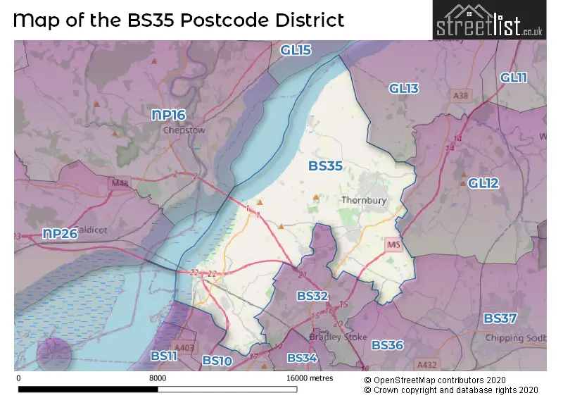
Map of the Postcode District
Explore the postcode district by using our interactive map.
Circles represent recorded crime; the larger the circle, the higher the crime rates.
Your support helps keep this site running!
If you enjoy using this website, consider buying me a coffee to help cover hosting costs.
The postcode district located in the BS Bristol postal area , BS35 has a population of 24,401 residents according to the 2021 England and Wales Census.
The area of the district is 35.59 square miles (92.17 square kilometers or 22,775.84 acres).
Where is the BS35 District?
To give you an idea where the district is located we have created the following table showing nearby towns.
Nearest Towns to BS35
| Town | Distance (miles) | Direction |
|---|---|---|
| Bradley Stoke | 4.41 | SSE |
| Chepstow | 5.56 | WNW |
| Filton | 5.95 | S |
| Yate | 7.52 | ESE |
| Caldicot | 7.84 | W |
| Chipping Sodbury | 8.57 | ESE |
| Lydney | 9.10 | N |
| Wotton-under-Edge | 9.76 | ENE |
| Bristol | 10.03 | S |
| Dursley | 10.94 | ENE |
| Portishead | 11.55 | SW |
| Keynsham | 12.84 | SSE |
| Coleford | 13.74 | N |
| Nailsea | 13.95 | SW |
| Cinderford | 16.02 | N |
| Usk | 16.05 | WNW |
| Stonehouse | 16.06 | NE |
| Monmouth | 16.16 | NNW |
| Nailsworth | 16.42 | ENE |
The post town for this district is BRISTOL.
Postcode Information for District BS35 (Total Geographical Postcodes: 749)
| Location | Post Town | Sector | Number of Postcodes |
|---|---|---|---|
| Thornbury | BRISTOL | BS35 1 | 197 |
| Thornbury | BRISTOL | BS35 2 | 164 |
| Alveston | BRISTOL | BS35 3 | 94 |
| Olveston | BRISTOL | BS35 4 | 55 |
| Pilning | BRISTOL | BS35 4 | 55 |
| Severn Beach | BRISTOL | BS35 4 | 40 |
| Oldbury-on-Severn | BRISTOL | BS35 1 | 35 |
| Thornbury | BRISTOL | BS35 3 | 32 |
| Easter Compton | BRISTOL | BS35 5 | 28 |
| Rudgeway | BRISTOL | BS35 3 | 23 |
| Aust | BRISTOL | BS35 4 | 14 |
| Littleton-upon-Severn | BRISTOL | BS35 1 | 8 |
| Alveston | BRISTOL | BS35 2 | 4 |
Retail and Shopping in BS35
Street
Town
Locality
Number of Shops
Central Postcode
View on Google Maps
HIGH STREET
BRISTOL
THORNBURY
48
BS35 2AH
View on Google Maps
ST MARY STREET
BRISTOL
THORNBURY
19
BS35 2AB
View on Google Maps
ST MARYS WAY
BRISTOL
THORNBURY
15
BS35 2BH
View on Google Maps
THE PLAIN
BRISTOL
THORNBURY
10
BS35 2AG
View on Google Maps
BEACH ROAD
BRISTOL
SEVERN BEACH
8
BS35 4PQ
View on Google Maps
GREENHILL PARADE
BRISTOL
ALVESTON
7
BS35 3LU
View on Google Maps
HORSESHOE LANE
BRISTOL
THORNBURY
7
BS35 2AZ
View on Google Maps
| Street | Town | Locality | Number of Shops | Central Postcode | View on Google Maps |
|---|---|---|---|---|---|
| HIGH STREET | BRISTOL | THORNBURY | 48 | BS35 2AH | View on Google Maps |
| ST MARY STREET | BRISTOL | THORNBURY | 19 | BS35 2AB | View on Google Maps |
| ST MARYS WAY | BRISTOL | THORNBURY | 15 | BS35 2BH | View on Google Maps |
| THE PLAIN | BRISTOL | THORNBURY | 10 | BS35 2AG | View on Google Maps |
| BEACH ROAD | BRISTOL | SEVERN BEACH | 8 | BS35 4PQ | View on Google Maps |
| GREENHILL PARADE | BRISTOL | ALVESTON | 7 | BS35 3LU | View on Google Maps |
| HORSESHOE LANE | BRISTOL | THORNBURY | 7 | BS35 2AZ | View on Google Maps |
The primary settlement in the BS35 postcode district is Thornbury, located in the county of Gloucestershire. Other significant settlements include Littleton-upon-Severn, Oldbury-on-Severn, Alveston, Rudgeway, Aust, Olveston, Pilning, Severn Beach, and Easter Compton. The post town for the BS35 postcode district is Bristol.
When it comes to local government, postal geography often disregards political borders. However, this district intersects the following councils: the district mostly encompasses the South Gloucestershire area with a total of 757 postal codes.
The largest settlement in the BS35 postal code is Thornbury followed by Alveston, and Severn Beach.
The postcode area has a boundary with The Bristol Channel.
The BS35 Postcode shares a border with GL12 (WOTTON-UNDER-EDGE, Charfield, Wickwar), BS36 (Frampton Cotterell, Winterbourne, Coalpit Heath), BS37 (Yate, Chipping Sodbury, Iron Acton), BS10 (BRISTOL, Westbury-on-Trym, Henbury), BS32 (Bradley Stoke, Almondsbury, Tockington) and NP16 (CHEPSTOW, BULWARK, Tutshill).


Schools in the Sector
Christ The King Catholic Primary School, Thornbury
Phase: Primary
Address: Easton Hill Road , Thornbury , Bristol
Postcode: BS35 1AW
Headteacher: Mrs Mary Mainwaring (Headteacher)
Ofsted Rating: Good
St Mary's Church of England Primary School, Thornbury
Phase: Primary
Address: Church Road , Thornbury , Bristol
Postcode: BS35 1HJ
Headteacher: Mrs S Gillman (Headteacher)
Ofsted Rating: Outstanding
Sheiling School
Phase: Not applicable
Address: Thornbury Park , Park Road , Thornbury , South Gloucestershire
Postcode: BS35 1HP
Headteacher: Mr Dean Frances-Hawksley (Headteacher)
Ofsted Rating: Requires improvement
The Castle School
Phase: Secondary
Address: Park Road , Thornbury , Bristol
Postcode: BS35 1HT
Headteacher: Ms Jessica Lobbett (Headteacher)
Ofsted Rating: Good
Manorbrook Primary School
Phase: Primary
Address: Park Road , Thornbury , Bristol
Postcode: BS35 1JW
Headteacher: Mr Darren Stanley (Headteacher)
Ofsted Rating: Good
Oldbury on Severn Church of England Primary School
Phase: Primary
Address: Church Road , Oldbury-on-Severn , Thornbury , Bristol
Postcode: BS35 1QG
Headteacher: Amanda Flanagan (Headteacher)
Ofsted Rating: Good
Gillingstool Primary School
Phase: Primary
Address: Gillingstool , Thornbury , Bristol
Postcode: BS35 2EG
Headteacher: Mrs Caroline Carter (Headteacher)
Ofsted Rating: Good
Crossways Junior School
Phase: Primary
Address: Knapp Road , Thornbury , Bristol
Postcode: BS35 2HQ
Headteacher: Mrs Jo Geoghegan (Executive Headteacher)
Ofsted Rating: Good
Crossways Infant School
Phase: Primary
Address: Knapp Road , Thornbury , Bristol
Postcode: BS35 2HQ
Headteacher: Mrs Jo Geoghegan (Headteacher)
Ofsted Rating: Requires improvement
New Siblands School
Phase: Not applicable
Address: Easton Hill Road , Thornbury , Bristol
Postcode: BS35 2JU
Headteacher: Mr Andrew Buckton (Headteacher)
Ofsted Rating: Outstanding
New Siblands School
Phase: Not applicable
Address: Easton Hill Road , Thornbury , Bristol
Postcode: BS35 2JU
Headteacher: Mr Karl Hemmings (Headteacher)
Ofsted Rating: Outstanding
St Helen's Church of England Primary School
Phase: Primary
Address: Greenhill , Alveston , Bristol
Postcode: BS35 2QX
Headteacher: Mr Kelvin Chappell/Mrs Julie Simpson (Headteacher)
Ofsted Rating: Outstanding
Marlwood School
Phase: Secondary
Address: Vattingstone Lane , Alveston , Bristol
Postcode: BS35 3LA
Headteacher: Miss Seema Purewal ()
Ofsted Rating: Good
Olveston Church of England Primary School
Phase: Primary
Address: Elberton Road , Olveston , Bristol
Postcode: BS35 4DB
Headteacher: Mr Lee Dunn (Headteacher)
Ofsted Rating: Good
St Peter's Anglican / Methodist VC Primary
Phase: Primary
Address: Bank Road , Pilning , Bristol
Postcode: BS35 4JG
Headteacher: Mr Paul Smith (Head Teacher)
Ofsted Rating: Good
Aurora Hedgeway School
Phase: Not applicable
Address: Rookery Lane , Pilning
Postcode: BS35 4JN
Headteacher: Miss Klaire Rowland (Principal)
Ofsted Rating: Good
Severn Beach Primary School
Phase: Primary
Address: Ableton Lane , Severn Beach , Bristol
Postcode: BS35 4PP
Headteacher: Mrs Bethan Adams (Headteacher)
Ofsted Rating: Good
Stations in the Sector
Pilning
CRS Code: PIL
Operator: GW
Line: South Wales Main Line
Company: Great Western Railway
Severn Beach
CRS Code: SVB
Operator: GW
Line: Severn Beach Line
Company: Great Western Railway
Accessable Motorway Junctions
M5 J17
Average Driving Time from within the district: 6.55
Average Driving Distance: 3.25
Number of Postcodes that can access the Motorway Junction: 120
M5 J16
Average Driving Time from within the district: 6.79
Average Driving Distance: 4.30
Number of Postcodes that can access the Motorway Junction: 304
M5 J14
Average Driving Time from within the district: 6.94
Average Driving Distance: 4.56
Number of Postcodes that can access the Motorway Junction: 454
M48 J1
Average Driving Time from within the district: 7.70
Average Driving Distance: 4.83
Number of Postcodes that can access the Motorway Junction: 703
M5 J18
Average Driving Time from within the district: 8.47
Average Driving Distance: 6.08
Number of Postcodes that can access the Motorway Junction: 6
M48 J2
Average Driving Time from within the district: 8.87
Average Driving Distance: 6.76
Number of Postcodes that can access the Motorway Junction: 76
M5 J15
Average Driving Time from within the district: 9.18
Average Driving Distance: 5.85
Number of Postcodes that can access the Motorway Junction: 609
M4 J20
Average Driving Time from within the district: 9.19
Average Driving Distance: 5.92
Number of Postcodes that can access the Motorway Junction: 672
M5 J18A
Average Driving Time from within the district: 9.45
Average Driving Distance: 6.03
Number of Postcodes that can access the Motorway Junction: 34
M4 J19
Average Driving Time from within the district: 9.79
Average Driving Distance: 6.49
Number of Postcodes that can access the Motorway Junction: 6
M4 J22
Average Driving Time from within the district: 13.70
Average Driving Distance: 11.14
Number of Postcodes that can access the Motorway Junction: 138
Weather Forecast for Thornbury
| Time Period | Icon | Description | Temperature | Rain Probability | Wind |
|---|---|---|---|---|---|
| 12:00 to 15:00 | Cloudy | 15.0°C (feels like 13.0°C) | 14.00% | WSW 11 mph | |
| 15:00 to 18:00 | Sunny day | 15.0°C (feels like 13.0°C) | 1.00% | WSW 9 mph | |
| 18:00 to 21:00 | Clear night | 12.0°C (feels like 11.0°C) | 0.00% | SW 7 mph | |
| 21:00 to 00:00 | Clear night | 11.0°C (feels like 10.0°C) | 0.00% | SSW 4 mph |
| Time Period | Icon | Description | Temperature | Rain Probability | Wind |
|---|---|---|---|---|---|
| 00:00 to 03:00 | Clear night | 10.0°C (feels like 9.0°C) | 1.00% | S 4 mph | |
| 03:00 to 06:00 | Fog | 10.0°C (feels like 9.0°C) | 11.00% | SSE 4 mph | |
| 06:00 to 09:00 | Mist | 10.0°C (feels like 9.0°C) | 12.00% | S 4 mph | |
| 09:00 to 12:00 | Mist | 11.0°C (feels like 10.0°C) | 12.00% | S 7 mph | |
| 12:00 to 15:00 | Partly cloudy (day) | 15.0°C (feels like 13.0°C) | 2.00% | S 9 mph | |
| 15:00 to 18:00 | Partly cloudy (day) | 15.0°C (feels like 13.0°C) | 8.00% | S 11 mph | |
| 18:00 to 21:00 | Clear night | 12.0°C (feels like 11.0°C) | 1.00% | SSE 9 mph | |
| 21:00 to 00:00 | Clear night | 11.0°C (feels like 9.0°C) | 0.00% | SSE 9 mph |
| Time Period | Icon | Description | Temperature | Rain Probability | Wind |
|---|---|---|---|---|---|
| 00:00 to 03:00 | Clear night | 11.0°C (feels like 9.0°C) | 0.00% | SSE 9 mph | |
| 03:00 to 06:00 | Clear night | 11.0°C (feels like 9.0°C) | 0.00% | SE 9 mph | |
| 06:00 to 09:00 | Clear night | 11.0°C (feels like 8.0°C) | 1.00% | SSE 9 mph | |
| 09:00 to 12:00 | Overcast | 13.0°C (feels like 10.0°C) | 7.00% | SSE 13 mph | |
| 12:00 to 15:00 | Overcast | 15.0°C (feels like 13.0°C) | 9.00% | S 16 mph | |
| 15:00 to 18:00 | Cloudy | 16.0°C (feels like 13.0°C) | 7.00% | SSE 13 mph | |
| 18:00 to 21:00 | Cloudy | 15.0°C (feels like 12.0°C) | 18.00% | SSE 13 mph | |
| 21:00 to 00:00 | Light rain | 14.0°C (feels like 12.0°C) | 51.00% | S 13 mph |
| Time Period | Icon | Description | Temperature | Rain Probability | Wind |
|---|---|---|---|---|---|
| 00:00 to 03:00 | Light rain | 13.0°C (feels like 11.0°C) | 54.00% | SSW 11 mph | |
| 03:00 to 06:00 | Partly cloudy (night) | 12.0°C (feels like 9.0°C) | 12.00% | SSW 11 mph | |
| 06:00 to 09:00 | Partly cloudy (night) | 10.0°C (feels like 8.0°C) | 7.00% | SSW 9 mph | |
| 09:00 to 12:00 | Partly cloudy (day) | 11.0°C (feels like 9.0°C) | 6.00% | SSW 11 mph | |
| 12:00 to 15:00 | Cloudy | 13.0°C (feels like 11.0°C) | 20.00% | SW 11 mph | |
| 15:00 to 18:00 | Light rain shower (day) | 12.0°C (feels like 10.0°C) | 35.00% | WSW 11 mph | |
| 18:00 to 21:00 | Partly cloudy (night) | 10.0°C (feels like 7.0°C) | 6.00% | WSW 11 mph | |
| 21:00 to 00:00 | Partly cloudy (night) | 9.0°C (feels like 6.0°C) | 3.00% | SW 11 mph |
| Time Period | Icon | Description | Temperature | Rain Probability | Wind |
|---|---|---|---|---|---|
| 00:00 to 03:00 | Clear night | 8.0°C (feels like 6.0°C) | 6.00% | SW 11 mph | |
| 03:00 to 06:00 | Partly cloudy (night) | 8.0°C (feels like 6.0°C) | 7.00% | SW 11 mph | |
| 06:00 to 09:00 | Cloudy | 9.0°C (feels like 6.0°C) | 14.00% | SW 9 mph | |
| 09:00 to 12:00 | Partly cloudy (day) | 10.0°C (feels like 8.0°C) | 9.00% | SW 11 mph | |
| 12:00 to 15:00 | Cloudy | 12.0°C (feels like 10.0°C) | 17.00% | SW 13 mph | |
| 15:00 to 18:00 | Cloudy | 13.0°C (feels like 10.0°C) | 18.00% | SW 11 mph | |
| 18:00 to 21:00 | Light rain shower (night) | 11.0°C (feels like 9.0°C) | 30.00% | SW 11 mph | |
| 21:00 to 00:00 | Clear night | 11.0°C (feels like 9.0°C) | 6.00% | WSW 9 mph |
| Postal Sector | Delivery Office |
|---|---|
| BS35 1 | Thornbury Delivery Office |
| BS35 2 | Thornbury Delivery Office |
| BS35 3 | Thornbury Delivery Office |
| BS35 4 | Pilning Scale Payment Delivery Office |
| BS35 5 | Easter Compton Scale Payment Delivery Office |
| B | S | 3 | 5 | - | X | X | X |
| B | S | 3 | 5 | Space | Numeric | Letter | Letter |
Tourist Attractions
We found 1 visitor attractions.
| Thornbury and District Museum |
|---|
| Museums & Art Galleries |
| Museum and / or Art Gallery |
| View Thornbury and District Museum on Google Maps |
Street List for the BS35 District
Current Monthly Rental Prices
| # Bedrooms | Min Price | Max Price | Avg Price |
|---|---|---|---|
| 2 | £1,100 | £1,400 | £1,250 |
| 3 | £1,300 | £2,500 | £1,690 |
| 4 | £1,795 | £1,795 | £1,795 |
Current House Prices
| # Bedrooms | Min Price | Max Price | Avg Price |
|---|---|---|---|
| £1,250,000 | £1,250,000 | £1,250,000 | |
| 3 | £795,000 | £875,000 | £835,000 |
| 4 | £670,000 | £1,600,000 | £902,042 |
| 5 | £775,000 | £2,500,000 | £1,337,500 |
| 6 | £950,000 | £950,000 | £950,000 |
| 7 | £1,300,000 | £1,300,000 | £1,300,000 |
| 8 | £1,275,000 | £1,275,000 | £1,275,000 |
Estate Agents
| Logo | Name | Brand Name | Address | Contact Number |
|---|---|---|---|---|
 | Thornbury | Lisa Costa Residential Sales & Lettings | 53 High Street, Thornbury, BS35 2AR | 01454 800949 |
 | Thornbury | Milburys | 61 High Street, Thornbury, BS35 2AP | 01454 801767 |
 | Thornbury | Hunters | 57 High Street, Thornbury, BS35 2AP | 01454 803924 |
 | Thornbury | Bonds Of Thornbury | 14 The Plain, Thornbury, Bristol, BS35 2BD | 01454 802518 |
 | Cleve Wood | Sovereign Housing Association | Morton Way, Thornbury, Bristol, BS35 3TS | 07900 753073 |
- Alveston
- Aust
- Avonmouth
- Awkley
- Compton Greenfield
- Cowhill
- Crossways
- Earthcott Green
- Easter Compton
- Elberton
- Grovesend
- Ingst
- Itchington
- Kington
- Latteridge
- Littleton-upon-Severn
- Lower Hazel
- Lower Morton
- Marsh Common
- New Passage
- Old Down
- Old Passage
- Oldbury Naite
- Oldbury-on-Severn
- Olveston
- Pilning
- Redwick
- Rudgeway
- Severn Beach
- Shepperdine
- The Hacket
- Thornbury
- Tockington
- Upper Morton
- Woodhouse Down
Yearly House Price Averages for the District
| Type of Property | 2018 Average | 2018 Sales | 2017 Average | 2017 Sales | 2016 Average | 2016 Sales | 2015 Average | 2015 Sales |
|---|---|---|---|---|---|---|---|---|
| Detached | £455,289 | 175 | £442,150 | 153 | £418,867 | 153 | £380,028 | 155 |
| Semi-Detached | £300,143 | 182 | £288,600 | 108 | £282,336 | 114 | £259,817 | 129 |
| Terraced | £270,268 | 122 | £264,530 | 118 | £249,280 | 92 | £211,693 | 109 |
| Flats | £170,327 | 32 | £189,303 | 39 | £175,966 | 38 | £188,128 | 66 |