This section of the site is all about the NP Postcode area, also known as the Newport Postal Area. Explore links to the next level to learn more about specific postcode districts such as NP10.
The NP postcode area represents a group of postal districts in the Newport area of the United Kingdom. The area code NP stands for the letters n and p in NewPort. NP has a population of 488,368 and covers an area of 1,657,847 hectares. Fun fact: 0.75% of the population of Great Britain lives in this area.
The postcode area falls within the following counties: Gwent (97.11%), Gloucestershire (1.39%), Powys (1.37%), Herefordshire (0.14%).
Post Towns and Postcode Districts for the NP Postcode
Where is the NP Postcode Area?
The NP Newport Postcode is in Wales. The postal area borders the following neighbouring postal areas: LD - Llandrindod Wells, GL - Gloucester, CF - Cardiff, HR - Hereford and BS - Bristol, It also borders The Bristol Channel,
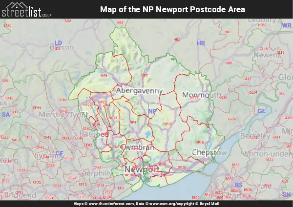
Map of the NP Newport Postcode Area
Explore the NP Newport postcode area by using our interactive map.


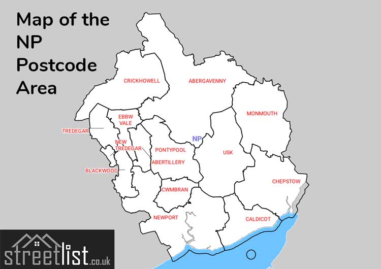
Postcode Districts within the NP Newport Postcode Area
There are 18 postcode districts within the Newport postcode area
A map showing the boundary of in relation to other areas
There are 22 towns within the Newport postcode area.
| Unit | Area² |
|---|---|
| Hectares | 1,657,847² |
| Miles | 6,401² |
| Feet | 178,448,993,233² |
| Kilometres | 16,578² |
Postal Delivery Offices serving the NP Newport Postcode Area
- Abercarn Delivery Office
- Abergavenny Delivery Office
- Abertillery Delivery Office
- Blackwood Delivery Office
- Caldicot Delivery Office
- Chepstow Delivery Office
- Cwmbran Delivery Office
- Ebbw Vale Delivery Office
- Monmouth Delivery Office
- Newport East Delivery Office
- Newport West Delivery Office
- Pontypool Delivery Office
- Tredegar Delivery Office
- Usk Delivery Office
Councils with Postcodes in NP
Towns and Villages within the NP Newport Postcode Area
- Aberbargoed - village
- Aberbeeg / Aber-big - village
- Abercarn - town
- Abersychan - town
- Abertyleri / Abertillery - town
- Abertysswg - village
- Argoed - village
- Beachley - village
- Bishton - village
- Blaina / Y Blaenau - town
- Broadstone - village
- Broadstreet Common - village
- Brockweir - village
- Brynawel - village
- Brynbuga / Usk - town
- Brynithel - village
- Brynmawr / Bryn-Mawr - town
- Brynygwenin - village
- Bute Town - village
- Caerleon / Caerllion - town
- Caerwent - village
- Caldicot / Cil-y-coed - town
- Cas-Gwent / Chepstow - town
- Casnewydd / Newport - city
- Catbrook - village
- Cheltenham - village
- Clydach - village
- Coed-y-paen - village
- Crick - village
- Crughywel / Crickhowell - town
- Cwm - village
- Cwm-nant-gwynt - village
- Cwmavon - village
- Cwmbran - town
- Cwmdu - village
- Cwmfelinfach - village
- Daren-felen - village
- Devauden - village
- Dingestow - village
- Draethen - village
- Earlswood - otherSettlement
- Ebbw Vale - town
- Fleur-de-lis - village
- Garn-yr-erw - village
- Gellifelen - otherSettlement
- Gilwern - village
- Glan-y-nant - village
- Glandwr - village
- Glangrwyney - village
- Glascoed - village
- Govilon - village
- Great Oak - village
- Grosmont - village
- Gwehelog Common - village
- Gwndy / Undy - village
- Hafodyrynys - village
- Hollybush - village
- Itton Common - village
- Kymin - village
- Langstone - village
- Little Mill - village
- Llanbedr - village
- Llanddewi Rhydderch - village
- Llandegveth - village
- Llandevaud - village
- Llandogo - village
- Llanellen - village
- Llanfable / Llanvapley - village
- Llanfair Kilgeddin - village
- Llanfoist / Llanffwyst - village
- Llanfrechfa - village
- Llangattock Nigh Usk / Llangatwg Dyffryn Wysg - village
- Llangatwg / Llangattock - village
- Llangenau / Llangenny - village
- Llangibby / Llangybi - village
- Llangynidr - village
- Llanhiledd / Llanhilleth - village
- Llanishen - village
- Llanmartin - village
- Llannarth / Llanarth - village
- Llanover - village
- Llansoy - village
- Llanvaches - village
- Llanvair-Discoed - village
- Llanvihangel Crucorney - village
- Llanwern - village
- Lower Redbrook - village
- Maesycwmmer - village
- Maesygwartha - village
- Manson - village
- Markham - village
- Merthyr-Tewdrig / Mathern - village
- Mitchel Troy - village
- Mitcheltroy Common - village
- Monkswood - village
- Mynydd-bach - village
- Nantyglo - town
- Nash - village
- New Tredegar - village
- Oakdale - village
- Pandy - village
- Parc-Seymour - village
- Pen-twyn - village
- Pen-twyn - village
- Penallt - otherSettlement
- Pengam - village
- Penperlleni - village
- Ponthir - village
- Pontllanfraith - town
- Pontypool - town
- Porthsgiwed / Portskewett - village
- Pwllmeyric / Pwllmeurig - village
- Redwick - village
- Rhaglan / Raglan - village
- Rhisga - town
- Rhymney / Rhymni - town
- Rockfield - village
- Rogiet - village
- Sedbury - village
- Shirenewton - village
- St Arvans - village
- St Brides Wentlooge / Llansanffraid Gwynllwg - village
- Sudbrook - village
- Swffryd - village
- The Narth - village
- Tidenham Chase - otherSettlement
- Trecceln / Newbridge - town
- Tredegar - town
- Trefil - village
- Trefynwy / Monmouth - town
- Trellech - village
- Tretwr / Tretower - village
- Triangle - village
- Trinant - village
- Tutshill - village
- Ty-Du / Rogerstone - village
- Tyndyrn / Tintern - village
- Underwood - village
- Upper Redbrook - village
- Wattsville - village
- Waunllapria - village
- Welsh Newton Common - village
- Werngifford - village
- Whitson - village
- Woodcroft - village
- Wyllie - village
- Y Coed Duon / Blackwood - town
- Y Fenni / Abergavenny - town
- Ynysddu - village