This section of the site is all about the CF Postcode area, also known as the Cardiff Postal Area. Explore links to the next level to learn more about specific postcode districts such as CF10.
The CF postcode area represents a group of postal districts in the Cardiff area of the United Kingdom. The area code CF stands for the letters c and f in CardifF. CF has a population of 1,005,334 and covers an area of 1,550,103 hectares. Fun fact: 1.55% of the population of Great Britain lives in this area.
The postcode area falls within the following counties: South Glamorgan (47.90%), Mid Glamorgan (42.89%), Gwent (9.15%), Powys (0.03%), West Glamorgan (0.03%).
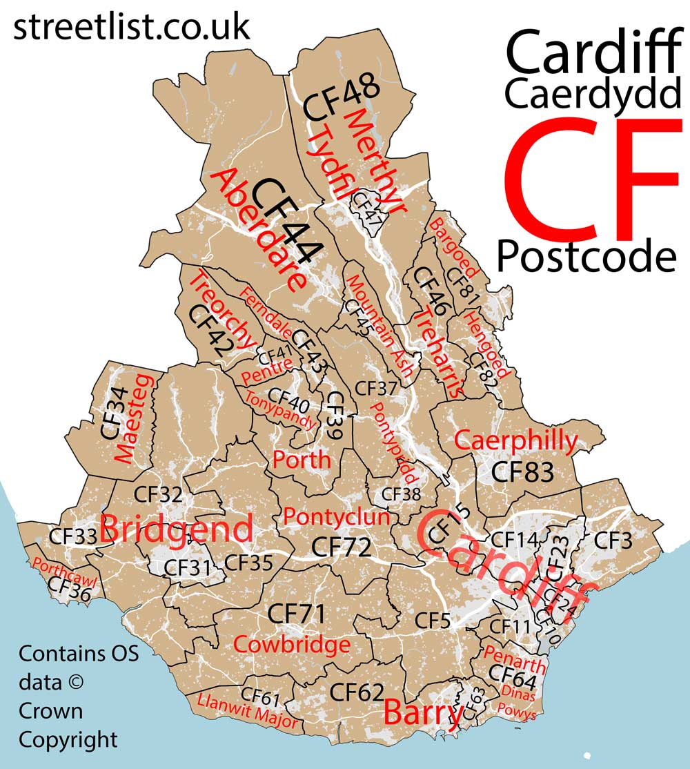
Post Towns and Postcode Districts for the CF Postcode
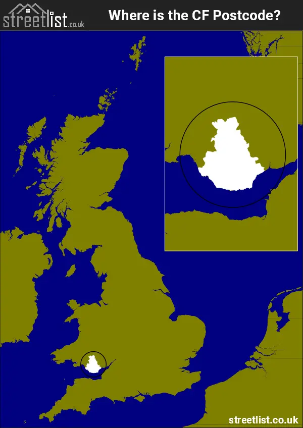
Where is the CF Postcode Area?
The CF Cardiff Postcode is in Wales. The postal area borders the following neighbouring postal areas: LD - Llandrindod Wells, SA - Swansea and NP - Newport, It also borders The Bristol Channel,
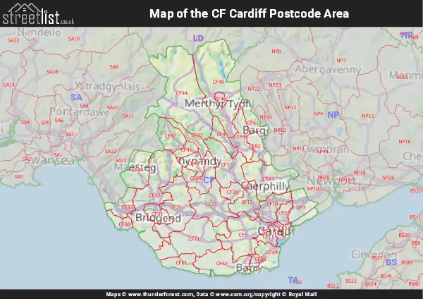
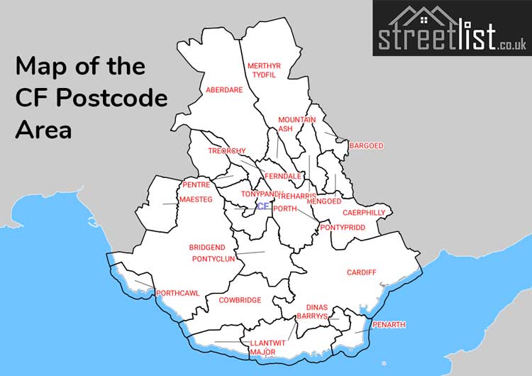
Map of the CF Cardiff Postcode Area
Explore the CF Cardiff postcode area by using our interactive map.
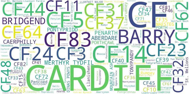
Postcode Districts within the CF Cardiff Postcode Area
There are 35 postcode districts within the Cardiff postcode area
A map showing the boundary of in relation to other areas
There are 27 towns within the Cardiff postcode area.
| Unit | Area² |
|---|---|
| Hectares | 1,550,103² |
| Miles | 5,985² |
| Feet | 166,851,536,817² |
| Kilometres | 15,501² |
Postal Delivery Offices serving the CF Cardiff Postcode Area
- Aberdare Delivery Office
- Barry Delivery Office
- Bridgend (cf) Delivery Office
- Caerphilly Delivery Office
- Cardiff-north East
- Cardiff Delivery Office
- Cardiff East Delivery Office
- Cardiff North Delivery Office
- Cardiff North West Delivery Office
- Cardiff West Delivery Office
- Ferndale Delivery Office
- Hengoed Delivery Office
- Maesteg Delivery Office
- Merthyr Tydfil Delivery Office
- Mid Rhondda Ganol Delivery Office
- Mountain Ash Delivery Office
- Penarth Delivery Office
- Pontyclun Delivery Office
- Pontypridd Delivery Office
- Porthcawl Delivery Office
- St. Athan Scale Payment Delivery Office
- Treharris Delivery Office
- Treorchy Delivery Office
- Vale Of Glamorgan Delivery Office
Councils with Postcodes in CF
Towns and Villages within the CF Cardiff Postcode Area
- Aberbargoed - village
- Abercanaid - village
- Abercynffig - village
- Abercynon - town
- Aberdare - town
- Aberfan - village
- Aberpennar / Mountain Ash - town
- Aberthin - village
- Abertridwr - village
- Bargoed / Bargod - town
- Barry - town
- Beddau - village
- Bedlinog - village
- Bedwas - village
- Bettws - village
- Blackmill - village
- Blaengarw - village
- Bridgend - town
- Bryncae - village
- Bryncethin - village
- Brynmenyn - village
- Brynna - village
- Brynnau Gwynion - village
- Brynsadler - village
- Caerphilly - town
- Capel Llanilltern - village
- Cardiff - city
- Castleton - village
- Cefn Cribwr - village
- Cefn Rhigos - village
- Church Village - village
- Coedely - village
- Corntown - village
- Coytrahon - village
- Creigiau - village
- Cross Inn - village
- Cwmfelin - village
- Deri - village
- Dinas Powys - village
- Dolau - village
- Downs - village
- East Aberthaw - village
- Efail Isaf - village
- Eglwys-Brewis - village
- Ewenny - village
- Ferndale - town
- Fleur-de-lis - village
- Fochriw - village
- Font-y-gary - village
- Gelligaer - village
- Gilfach Goch - village
- Glan-y-nant - village
- Goitre Coed - village
- Graig Penllyn - village
- Groes-faen - village
- Gwaelod-y-garth - village
- Gwenfo - village
- Hendreforgan - village
- Heol-y-Cyw - village
- Kenfig Hill / Mynyddcynffig - village
- Lewistown - village
- Llan-fair - village
- Llanbedr Gwynllwg / Peterstone Wentlooge - village
- Llanbedr-y-fro / Peterston-super-Ely - village
- Llanbradach - village
- Llandouche / Llandough - village
- Llandw / Llandow - village
- Llangeinor - village
- Llanharan - village
- Llanharry - village
- Llanmaes - village
- Llantrisant - town
- Llantwit Fardre / Llanilltud Faerdref - village
- Llantwit Major / Llanilltud Fawr - town
- Machen - village
- Maerdy - village
- Maesteg - town
- Maesycwmmer - village
- Marcroes / Marcross - village
- Marshfield - village
- Mawdlam - village
- Meisgyn / Miskin - village
- Merthyr Tydfil - town
- Nant-y-moel - village
- Nantgarw - village
- Nelson - village
- North Cornelly - village
- Ogmore Vale / Cwm Ogwr - village
- Ogmore-by-Sea / Aberogwr - village
- Pant-yr-Awel - village
- Pen-marc / Penmark - village
- Pen-pedair-heol - village
- Pen-y-coedcae - village
- Pen-y-fai - village
- Penarth - town
- Pencoed - town
- Penderyn - village
- Pendeulwyn / Pendoylan - village
- Penrhys - village
- Pentrebach - village
- Pentref Llanedeyrn / Llanedeyrn Village - village
- Pentyrch - village
- Penybryn - village
- Pont Rhyd-y-cyff - village
- Pont-y-rhyl - village
- Pontlottyn - village
- Pontsticill - village
- Pontyclun - village
- Pontycymer - town
- Pontygwaith - village
- Pontypridd - town
- Porth - town
- Porthcawl - town
- Price Town - village
- Rhigos - village
- Rhondda - town
- Rhydlafr - village
- Rhymney / Rhymni - town
- Sain Dunwyd / St Donat's - village
- Sain Tathan / St Athan - village
- Saint Hilari / St Hilary - village
- Saint-y-brid / St Brides Major - village
- Sarn - village
- Senghenydd - village
- South Cornelly - village
- Southerndown - village
- St Fagans / Sain Ffagan - village
- St Nicholas / Sain Nicolas - village
- Taff's Well - village
- Talbot Green - town
- Tir-y-berth - village
- Tondu - village
- Tongwynlais - village
- Tonypandy - town
- Tonyrefail - village
- Trebefered / Boverton - village
- Trefflemin / Flemingston - village
- Tregolwyn - village
- Treharris - town
- Treherbert - town
- Trelales - village
- Trelewis - village
- Treoes - village
- Treorchy / Treorci - town
- Tresimwn / Bonvilston - village
- Trethomas - village
- Troedyrhiw - village
- Twyn Bryn-hor - village
- Tylorstown - village
- Waterloo - village
- Wattstown - village
- Wyndham - village
- Wyndham Park - village
- Y Bont-Faen / Cowbridge - town
- Y Pil / Pyle - village
- Y Rhws / Rhoose - village
- Y Wig / Wick - village
- Ynysowen / Merthyr Vale - village
- Ynysybwl - village
- Ystrad Mynach - town
- Ystradowen - village