The CF38 postcode district is a postal district located in the CF Cardiff postcode area with a population of 23,460 residents according to the 2021 England and Wales Census.
The area of the CF38 postcode district is 6.83 square miles which is 17.69 square kilometres or 4,370.17 acres.
Currently, the CF38 district has about 447 postcode units spread across 2 geographic postcode sectors.
Given that each sector allows for 400 unique postcode combinations, the district has a capacity of 800 postcodes. With 447 postcodes already in use, this leaves 353 units available.
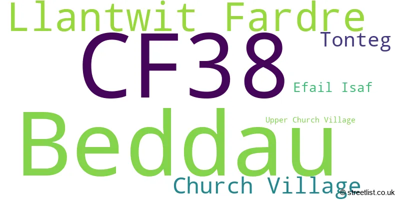
The largest settlement in the CF38 postal code is BEDDAU followed by CHURCH VILLAGE, and LLANTWIT FARDRE.
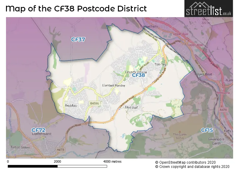
The CF38 Postcode shares a border with CF72 (LLANHARAN, TALBOT GREEN, LLANTRISANT), CF15 (RADYR, PENTYRCH, TONGWYNLAIS) and CF37 (PONTYPRIDD, TREFOREST, RHYDYFELIN).
The primary settlement in the CF38 postcode district is Church Village, located in the county of Mid Glamorgan. Other significant settlements in this postcode district include Efail Isaf, Llantwit Fardre, and Tonteg. The most significant post town in this postcode district is Pontypridd, also located in Mid Glamorgan.
For the district CF38, we have data on 2 postcode sectors. Here's a breakdown: The sector CF38 1, covers Church Village and Tonteg and Efail Isaf in Mid Glamorgan. The sector CF38 2, covers Beddau and Llantwit Fardre in Mid Glamorgan.

Map of the CF38 Postcode District
Explore the CF38 postcode district by using our free interactive map.
When it comes to local government, postal geography often disregards political borders. However, for a breakdown in the CF38 District: the district mostly encompasses the Rhondda Cynon Taf - Rhondda Cynon Taf area with a total of 449 postcodes.
Weather Forecast for CF38
Press Button to Show Forecast for Llantrisant
| Time Period | Icon | Description | Temperature | Rain Probability | Wind |
|---|---|---|---|---|---|
| 21:00 to 00:00 | Overcast | 8.0°C (feels like 5.0°C) | 18.00% | ENE 9 mph |
Press Button to Show Forecast for Llantrisant
| Time Period | Icon | Description | Temperature | Rain Probability | Wind |
|---|---|---|---|---|---|
| 00:00 to 03:00 | Light rain | 7.0°C (feels like 4.0°C) | 54.00% | NE 9 mph | |
| 03:00 to 06:00 | Overcast | 5.0°C (feels like 2.0°C) | 47.00% | NE 9 mph | |
| 06:00 to 09:00 | Overcast | 5.0°C (feels like 2.0°C) | 15.00% | ENE 11 mph | |
| 09:00 to 12:00 | Overcast | 6.0°C (feels like 3.0°C) | 12.00% | ENE 13 mph | |
| 12:00 to 15:00 | Overcast | 8.0°C (feels like 5.0°C) | 10.00% | ENE 11 mph | |
| 15:00 to 18:00 | Cloudy | 9.0°C (feels like 6.0°C) | 9.00% | NE 11 mph | |
| 18:00 to 21:00 | Cloudy | 9.0°C (feels like 6.0°C) | 5.00% | NE 11 mph | |
| 21:00 to 00:00 | Cloudy | 7.0°C (feels like 4.0°C) | 7.00% | NNE 11 mph |
Press Button to Show Forecast for Llantrisant
| Time Period | Icon | Description | Temperature | Rain Probability | Wind |
|---|---|---|---|---|---|
| 00:00 to 03:00 | Cloudy | 7.0°C (feels like 3.0°C) | 11.00% | NNE 13 mph | |
| 03:00 to 06:00 | Cloudy | 6.0°C (feels like 3.0°C) | 15.00% | N 11 mph | |
| 06:00 to 09:00 | Cloudy | 6.0°C (feels like 3.0°C) | 17.00% | NNW 9 mph | |
| 09:00 to 12:00 | Cloudy | 8.0°C (feels like 5.0°C) | 14.00% | NNW 9 mph | |
| 12:00 to 15:00 | Overcast | 10.0°C (feels like 8.0°C) | 15.00% | WNW 9 mph | |
| 15:00 to 18:00 | Cloudy | 11.0°C (feels like 9.0°C) | 9.00% | W 11 mph | |
| 18:00 to 21:00 | Sunny day | 10.0°C (feels like 8.0°C) | 1.00% | W 11 mph | |
| 21:00 to 00:00 | Clear night | 7.0°C (feels like 5.0°C) | 0.00% | W 9 mph |
Press Button to Show Forecast for Llantrisant
| Time Period | Icon | Description | Temperature | Rain Probability | Wind |
|---|---|---|---|---|---|
| 00:00 to 03:00 | Clear night | 6.0°C (feels like 4.0°C) | 2.00% | WSW 9 mph | |
| 03:00 to 06:00 | Partly cloudy (night) | 6.0°C (feels like 3.0°C) | 2.00% | SSW 9 mph | |
| 06:00 to 09:00 | Partly cloudy (day) | 7.0°C (feels like 5.0°C) | 3.00% | S 9 mph | |
| 09:00 to 12:00 | Partly cloudy (day) | 10.0°C (feels like 8.0°C) | 4.00% | S 13 mph | |
| 12:00 to 15:00 | Cloudy | 12.0°C (feels like 9.0°C) | 8.00% | S 16 mph | |
| 15:00 to 18:00 | Cloudy | 12.0°C (feels like 9.0°C) | 9.00% | S 16 mph | |
| 18:00 to 21:00 | Cloudy | 11.0°C (feels like 8.0°C) | 9.00% | S 16 mph | |
| 21:00 to 00:00 | Partly cloudy (night) | 10.0°C (feels like 7.0°C) | 6.00% | SSE 13 mph |
Press Button to Show Forecast for Llantrisant
| Time Period | Icon | Description | Temperature | Rain Probability | Wind |
|---|---|---|---|---|---|
| 00:00 to 03:00 | Cloudy | 9.0°C (feels like 6.0°C) | 10.00% | SE 13 mph | |
| 03:00 to 06:00 | Partly cloudy (night) | 9.0°C (feels like 6.0°C) | 7.00% | SE 13 mph | |
| 06:00 to 09:00 | Partly cloudy (day) | 9.0°C (feels like 6.0°C) | 8.00% | ESE 13 mph | |
| 09:00 to 12:00 | Cloudy | 11.0°C (feels like 8.0°C) | 13.00% | SE 16 mph | |
| 12:00 to 15:00 | Cloudy | 13.0°C (feels like 10.0°C) | 15.00% | SE 16 mph | |
| 15:00 to 18:00 | Light rain | 13.0°C (feels like 11.0°C) | 47.00% | SE 13 mph | |
| 18:00 to 21:00 | Cloudy | 13.0°C (feels like 10.0°C) | 13.00% | SE 11 mph | |
| 21:00 to 00:00 | Partly cloudy (night) | 11.0°C (feels like 9.0°C) | 6.00% | ESE 9 mph |
Where is the CF38 Postcode District?
The postcode district CF38 is located in Pontypridd, which is a district town. It is situated near several towns in different directions. To the South West is Pontyclun, which is approximately 3.48 miles away. To the East is Caerphilly, which is about 4.42 miles away. To the North West is Porth, approximately 5.31 miles away. To the South East is Cardiff, which is around 7.03 miles away. To the North is Treharris, about 7.24 miles away. Lastly, to the North East is Hengoed, which is approximately 7.86 miles away. Additionally, the postcode district CF38 is around 138.01 miles away from the centre of London.
The district is within the post town of PONTYPRIDD.
The sector has postcodes within the nation of Wales.
The CF38 Postcode District is in the Central Valleys region of West Wales within the Wales.
| Postcode Sector | Delivery Office |
|---|---|
| CF38 1 | Pontypridd Delivery Office |
| CF38 2 | Pontypridd Delivery Office |
| C | F | 3 | 8 | - | X | X | X |
| C | F | 3 | 8 | Space | Numeric | Letter | Letter |
Current Monthly Rental Prices
| # Bedrooms | Min Price | Max Price | Avg Price |
|---|---|---|---|
| 1 | £595 | £595 | £595 |
| 2 | £625 | £725 | £675 |
| 3 | £895 | £895 | £895 |
| 4 | £1,400 | £1,400 | £1,400 |
Current House Prices
| # Bedrooms | Min Price | Max Price | Avg Price |
|---|---|---|---|
| 2 | £230,000 | £230,000 | £230,000 |
| 4 | £415,000 | £669,999 | £496,352 |
| 5 | £435,000 | £645,000 | £535,000 |
| 6 | £419,950 | £419,950 | £419,950 |
Estate Agents who Operate in the CF38 District
| Logo | Name | Brand Name | Address | Contact Number | Total Properties |
|---|---|---|---|---|---|
 | Tonteg | Dylan Davies Estate Agents | 8 The Precinct, Main Road Church Village Pontypridd CF38 1SB | 01443 801715 | 33 |
 | Tonteg | Durbins Estate Agents | 5 The Precinct, Main Road, Church Village, CF38 1SB | 01443 706368 | 28 |
 | Pontypridd | Walker and Lewis Estate Agents Ltd | Glangors Main Road Church Village CF38 1RN | 01443 809394 | 11 |
 | Pontypridd | Sell Right Estate Agents | 20 Park Street, Treforest, Pontypridd, CF37 1SN | 01443 801862 | 10 |
 | Talbot Green | Peter Alan | 13 Talbot Road, Talbot Green, CF72 8AD | 01443 809385 | 10 |
| Type of Property | 2018 Average | 2018 Sales | 2017 Average | 2017 Sales | 2016 Average | 2016 Sales | 2015 Average | 2015 Sales |
|---|---|---|---|---|---|---|---|---|
| Detached | £263,210 | 99 | £253,542 | 136 | £256,184 | 192 | £235,930 | 196 |
| Semi-Detached | £155,606 | 164 | £155,777 | 201 | £143,628 | 205 | £144,911 | 232 |
| Terraced | £132,736 | 106 | £125,920 | 98 | £129,209 | 121 | £128,486 | 124 |
| Flats | £94,150 | 10 | £86,600 | 5 | £78,136 | 11 | £89,701 | 10 |