The CF72 postcode district is a postal district located in the CF Cardiff postcode area with a population of 27,959 residents according to the 2021 England and Wales Census.
The area of the CF72 postcode district is 25.14 square miles which is 65.11 square kilometres or 16,089.80 acres.
Currently, the CF72 district has about 656 postcode units spread across 2 geographic postcode sectors.
Given that each sector allows for 400 unique postcode combinations, the district has a capacity of 800 postcodes. With 656 postcodes already in use, this leaves 144 units available.
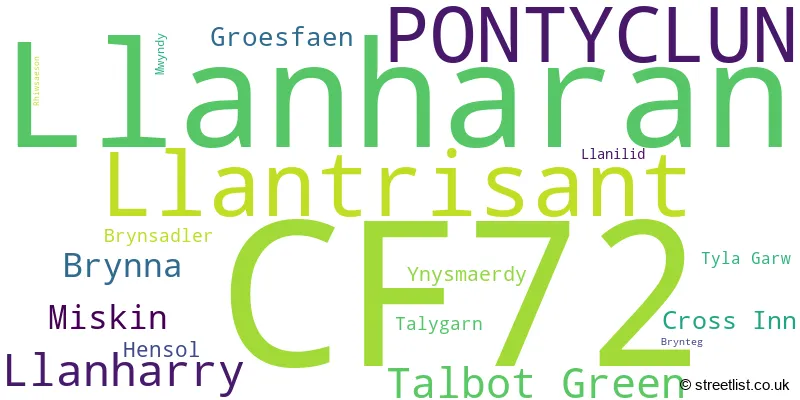
The largest settlement in the CF72 postal code is LLANHARAN followed by TALBOT GREEN, and LLANTRISANT.
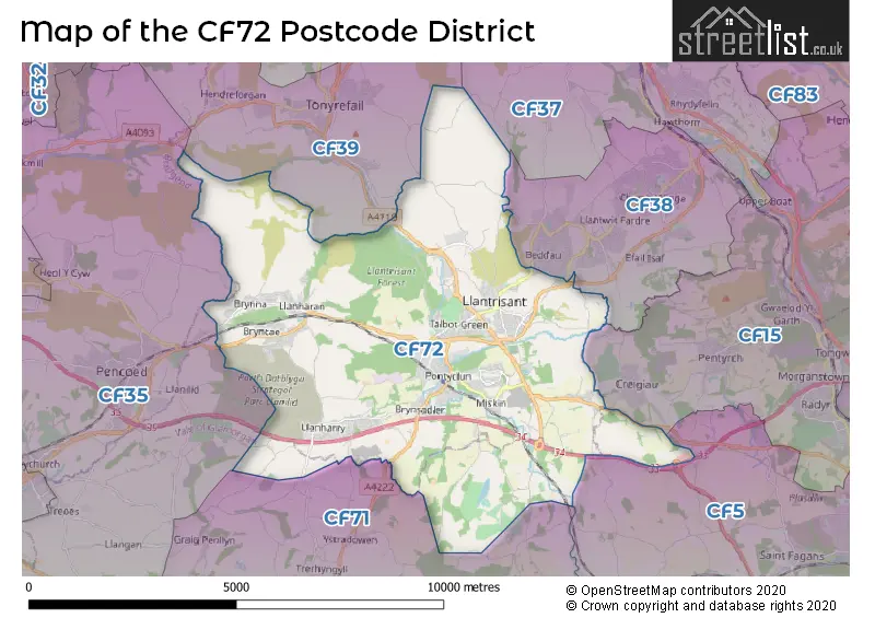
The CF72 Postcode shares a border with CF5 (CARDIFF, CANTON, FAIRWATER), CF15 (RADYR, PENTYRCH, TONGWYNLAIS), CF38 (BEDDAU, CHURCH VILLAGE, LLANTWIT FARDRE), CF39 (TONYREFAIL, PORTH, YNYS-HIR), CF35 (PENCOED, COITY, COYCHURCH) and CF71 (COWBRIDGE, WICK, LLANBLETHIAN).
The primary settlement in the CF72 postcode district is Pontyclun, located in the county of Mid Glamorgan in Wales. Other significant settlements in the district include Brynteg, Cross Inn, Groesfaen, Hensol, Llantrisant, Miskin, Mwyndy, Rhiwsaeson, Talbot Green, Ynysmaerdy, Brynna, Brynsadler, Llanharan, Llannharry, Talygarn, Tyla Garw. The most significant post town in the district is Pontyclun.
For the district CF72, we have data on 4 postcode sectors. Here's a breakdown: The sector CF72 0 is non-geographic. It's often designated for PO Boxes, large organisations, or special services. The sector CF72 4 is non-geographic. It's often designated for PO Boxes, large organisations, or special services. The sector CF72 8, covers Llantrisant and Talbot Green and Miskin in Mid Glamorgan. The sector CF72 9, covers Llanharan and Pontyclun and Llanharry and Brynna in Mid Glamorgan.

Map of the CF72 Postcode District
Explore the CF72 postcode district by using our free interactive map.
When it comes to local government, postal geography often disregards political borders. However, for a breakdown in the CF72 District: the district mostly encompasses the Rhondda Cynon Taf - Rhondda Cynon Taf (651 postcodes), followed by the Bro Morgannwg - the Vale of Glamorgan area (18 postcodes), and finally, the Caerdydd - Cardiff area (4 postcodes).
Weather Forecast for CF72
Press Button to Show Forecast for Llantrisant
| Time Period | Icon | Description | Temperature | Rain Probability | Wind |
|---|---|---|---|---|---|
| 09:00 to 12:00 | Overcast | 6.0°C (feels like 3.0°C) | 12.00% | ENE 13 mph | |
| 12:00 to 15:00 | Overcast | 8.0°C (feels like 5.0°C) | 10.00% | ENE 11 mph | |
| 15:00 to 18:00 | Cloudy | 9.0°C (feels like 6.0°C) | 9.00% | NE 11 mph | |
| 18:00 to 21:00 | Cloudy | 9.0°C (feels like 6.0°C) | 5.00% | NE 11 mph | |
| 21:00 to 00:00 | Cloudy | 7.0°C (feels like 4.0°C) | 7.00% | NNE 11 mph |
Press Button to Show Forecast for Llantrisant
| Time Period | Icon | Description | Temperature | Rain Probability | Wind |
|---|---|---|---|---|---|
| 00:00 to 03:00 | Cloudy | 7.0°C (feels like 3.0°C) | 11.00% | NNE 13 mph | |
| 03:00 to 06:00 | Cloudy | 6.0°C (feels like 3.0°C) | 15.00% | N 11 mph | |
| 06:00 to 09:00 | Cloudy | 6.0°C (feels like 3.0°C) | 17.00% | NNW 9 mph | |
| 09:00 to 12:00 | Cloudy | 8.0°C (feels like 5.0°C) | 14.00% | NNW 9 mph | |
| 12:00 to 15:00 | Overcast | 10.0°C (feels like 8.0°C) | 15.00% | WNW 9 mph | |
| 15:00 to 18:00 | Cloudy | 11.0°C (feels like 9.0°C) | 9.00% | W 11 mph | |
| 18:00 to 21:00 | Sunny day | 10.0°C (feels like 8.0°C) | 1.00% | W 11 mph | |
| 21:00 to 00:00 | Clear night | 7.0°C (feels like 5.0°C) | 0.00% | W 9 mph |
Press Button to Show Forecast for Llantrisant
| Time Period | Icon | Description | Temperature | Rain Probability | Wind |
|---|---|---|---|---|---|
| 00:00 to 03:00 | Clear night | 6.0°C (feels like 4.0°C) | 2.00% | WSW 9 mph | |
| 03:00 to 06:00 | Partly cloudy (night) | 6.0°C (feels like 3.0°C) | 2.00% | SSW 9 mph | |
| 06:00 to 09:00 | Partly cloudy (day) | 7.0°C (feels like 5.0°C) | 3.00% | S 9 mph | |
| 09:00 to 12:00 | Partly cloudy (day) | 10.0°C (feels like 8.0°C) | 4.00% | S 13 mph | |
| 12:00 to 15:00 | Cloudy | 12.0°C (feels like 9.0°C) | 8.00% | S 16 mph | |
| 15:00 to 18:00 | Cloudy | 12.0°C (feels like 9.0°C) | 9.00% | S 16 mph | |
| 18:00 to 21:00 | Cloudy | 11.0°C (feels like 8.0°C) | 9.00% | S 16 mph | |
| 21:00 to 00:00 | Partly cloudy (night) | 10.0°C (feels like 7.0°C) | 6.00% | SSE 13 mph |
Press Button to Show Forecast for Llantrisant
| Time Period | Icon | Description | Temperature | Rain Probability | Wind |
|---|---|---|---|---|---|
| 00:00 to 03:00 | Cloudy | 9.0°C (feels like 6.0°C) | 10.00% | SE 13 mph | |
| 03:00 to 06:00 | Partly cloudy (night) | 9.0°C (feels like 6.0°C) | 7.00% | SE 13 mph | |
| 06:00 to 09:00 | Partly cloudy (day) | 9.0°C (feels like 6.0°C) | 8.00% | ESE 13 mph | |
| 09:00 to 12:00 | Cloudy | 11.0°C (feels like 8.0°C) | 13.00% | SE 16 mph | |
| 12:00 to 15:00 | Cloudy | 13.0°C (feels like 10.0°C) | 15.00% | SE 16 mph | |
| 15:00 to 18:00 | Light rain | 13.0°C (feels like 11.0°C) | 47.00% | SE 13 mph | |
| 18:00 to 21:00 | Cloudy | 13.0°C (feels like 10.0°C) | 13.00% | SE 11 mph | |
| 21:00 to 00:00 | Partly cloudy (night) | 11.0°C (feels like 9.0°C) | 6.00% | ESE 9 mph |
Where is the CF72 Postcode District?
The CF72 postcode district is located in Pontyclun. Nearby towns include Cowbridge to the South, Pontypridd to the North East, Porth to the North, Bridgend to the West, Caerphilly to the East, and Llantwit Major to the South West. The CF72 postcode district is approximately 141.12 miles away from the centre of London.
The district is within the post town of PONTYCLUN.
The sector has postcodes within the nation of Wales.
The CF72 Postcode District is covers the following regions.
- Central Valleys - West Wales - Wales
- Cardiff and Vale of Glamorgan - East Wales - Wales
- Bridgend and Neath Port Talbot - West Wales - Wales
| Postcode Sector | Delivery Office |
|---|---|
| CF72 8 | Pontyclun Delivery Office |
| CF72 9 | Pontyclun Delivery Office |
| C | F | 7 | 2 | - | X | X | X |
| C | F | 7 | 2 | Space | Numeric | Letter | Letter |
Current Monthly Rental Prices
| # Bedrooms | Min Price | Max Price | Avg Price |
|---|---|---|---|
| 1 | £500 | £500 | £500 |
| 2 | £750 | £1,200 | £900 |
| 3 | £900 | £1,250 | £1,133 |
| 4 | £1,450 | £3,300 | £2,375 |
| 5 | £3,250 | £3,250 | £3,250 |
Current House Prices
| # Bedrooms | Min Price | Max Price | Avg Price |
|---|---|---|---|
| 3 | £550,000 | £550,000 | £550,000 |
| 4 | £549,950 | £1,250,000 | £694,788 |
| 5 | £570,000 | £1,250,000 | £828,995 |
| 6 | £550,000 | £645,000 | £597,500 |
Estate Agents who Operate in the CF72 District
| Logo | Name | Brand Name | Address | Contact Number | Total Properties |
|---|---|---|---|---|---|
 | Talbot Green | Peter Alan | 13 Talbot Road, Talbot Green, CF72 8AD | 01443 809385 | 36 |
 | Talbot Green | Hywel Anthony Estate Agents | 22 Stuart Terrace, Talbot Green, CF72 8AA | 01443 801729 | 29 |
 | Talbot Green | Nicholas Michael | Ty Gwyn, 38 Talbot Road, Talbot Green, CF72 8AF | 01443 801898 | 25 |
 | Talbot Green | 3EA | 103 Talbot Road Talbot Green CF72 8AE | 01443 706401 | 24 |
 | Cowbridge | Herbert R Thomas | 59 High Street, Cowbridge, CF71 7YL | 01446 772911 | 18 |
| Type of Property | 2018 Average | 2018 Sales | 2017 Average | 2017 Sales | 2016 Average | 2016 Sales | 2015 Average | 2015 Sales |
|---|---|---|---|---|---|---|---|---|
| Detached | £287,482 | 177 | £272,528 | 221 | £257,604 | 186 | £255,857 | 173 |
| Semi-Detached | £164,112 | 170 | £160,934 | 250 | £155,842 | 211 | £143,172 | 194 |
| Terraced | £144,249 | 102 | £149,603 | 114 | £147,868 | 118 | £134,266 | 136 |
| Flats | £203,253 | 16 | £119,830 | 33 | £143,266 | 43 | £227,769 | 26 |