The CF71 postcode district is a postal district located in the CF Cardiff postcode area with a population of 9,573 residents according to the 2021 England and Wales Census.
The area of the CF71 postcode district is 37.89 square miles which is 98.15 square kilometres or 24,252.72 acres.
Currently, the CF71 district has about 277 postcode units spread across 1 geographic postcode sectors.
Given that each sector allows for 400 unique postcode combinations, the district has a capacity of 400 postcodes. With 277 postcodes already in use, this leaves 123 units available.
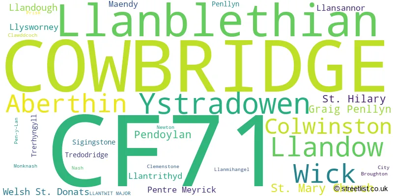
The largest settlement in the CF71 postal code is COWBRIDGE followed by WICK, and LLANBLETHIAN.
The postcode area has a boundary with The Bristol Channel.
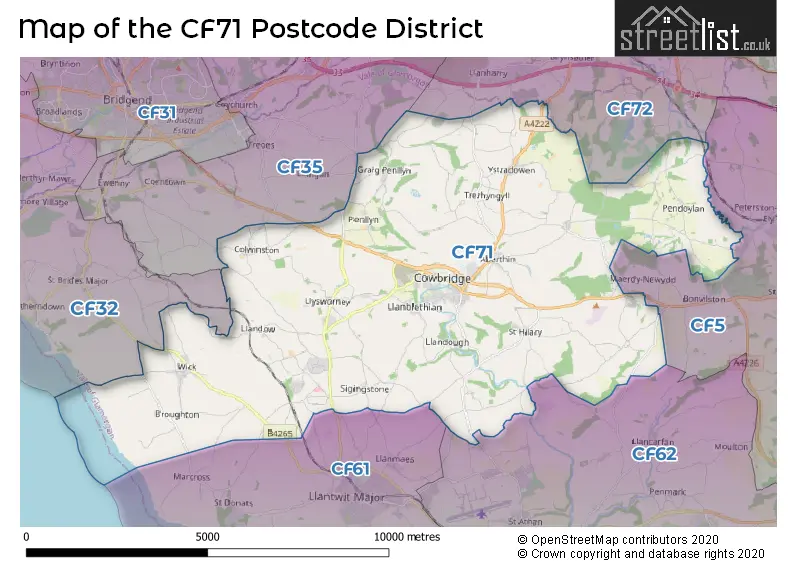
The CF71 Postcode shares a border with CF5 (CARDIFF, CANTON, FAIRWATER), CF72 (LLANHARAN, TALBOT GREEN, LLANTRISANT), CF62 (BARRY, RHOOSE, ST ATHAN), CF35 (PENCOED, COITY, COYCHURCH), CF61 (LLANTWIT MAJOR, BOVERTON, LLANMAES) and CF32 (TONDU, OGMORE VALE, SARN).
In the CF71 postcode district, the primary settlement with the highest count is Cowbridge. Other significant settlements in the district include Aberthin, Broughton, City, Clawddcoch, Clemenstone, Colwinston, Graig Penllyn, Llanblethian, Llandough, Llandow, Llanmihangel, Llansannor, Llantrithyd, Llysworney, Maendy, Monknash, Nash, Newton, Pen-y-Lan, Pendoylan, Penllyn, Pentre Meyrick, Prisk, Sigingstone, St. Hilary, St. Mary Church, Tredodridge, Trerhyngyll, Welsh St. Donats, Wick, and Ystradowen. The main post town for this district is Cowbridge, located in the county of South Glamorgan, which is in Wales.
For the district CF71, we have data on 2 postcode sectors. Here's a breakdown: The sector CF71 7, covers Cowbridge in South Glamorgan. The sector CF71 9 is non-geographic. It's often designated for PO Boxes, large organisations, or special services.
CF71 Postcode Sectors

Map of the CF71 Postcode District
Explore the CF71 postcode district by using our free interactive map.
When it comes to local government, postal geography often disregards political borders. However, for a breakdown in the CF71 District: the district mostly encompasses the Bro Morgannwg - the Vale of Glamorgan area with a total of 281 postcodes.
Weather Forecast for CF71
Press Button to Show Forecast for Cowbridge
| Time Period | Icon | Description | Temperature | Rain Probability | Wind |
|---|---|---|---|---|---|
| 06:00 to 09:00 | Overcast | 6.0°C (feels like 2.0°C) | 13.00% | ENE 13 mph | |
| 09:00 to 12:00 | Overcast | 7.0°C (feels like 3.0°C) | 12.00% | ENE 16 mph | |
| 12:00 to 15:00 | Cloudy | 9.0°C (feels like 6.0°C) | 6.00% | ENE 13 mph | |
| 15:00 to 18:00 | Overcast | 10.0°C (feels like 8.0°C) | 10.00% | NE 13 mph | |
| 18:00 to 21:00 | Cloudy | 9.0°C (feels like 7.0°C) | 6.00% | NE 13 mph | |
| 21:00 to 00:00 | Cloudy | 8.0°C (feels like 5.0°C) | 6.00% | NE 11 mph |
Press Button to Show Forecast for Cowbridge
| Time Period | Icon | Description | Temperature | Rain Probability | Wind |
|---|---|---|---|---|---|
| 00:00 to 03:00 | Cloudy | 7.0°C (feels like 4.0°C) | 10.00% | NNE 11 mph | |
| 03:00 to 06:00 | Overcast | 7.0°C (feels like 4.0°C) | 15.00% | N 11 mph | |
| 06:00 to 09:00 | Cloudy | 7.0°C (feels like 4.0°C) | 15.00% | NNW 9 mph | |
| 09:00 to 12:00 | Cloudy | 9.0°C (feels like 6.0°C) | 12.00% | NNW 9 mph | |
| 12:00 to 15:00 | Overcast | 11.0°C (feels like 9.0°C) | 16.00% | WNW 9 mph | |
| 15:00 to 18:00 | Cloudy | 11.0°C (feels like 9.0°C) | 7.00% | W 13 mph | |
| 18:00 to 21:00 | Sunny day | 11.0°C (feels like 8.0°C) | 3.00% | W 11 mph | |
| 21:00 to 00:00 | Clear night | 8.0°C (feels like 6.0°C) | 1.00% | WSW 9 mph |
Press Button to Show Forecast for Cowbridge
| Time Period | Icon | Description | Temperature | Rain Probability | Wind |
|---|---|---|---|---|---|
| 00:00 to 03:00 | Clear night | 8.0°C (feels like 6.0°C) | 2.00% | SW 9 mph | |
| 03:00 to 06:00 | Partly cloudy (night) | 7.0°C (feels like 5.0°C) | 2.00% | SSW 9 mph | |
| 06:00 to 09:00 | Cloudy | 8.0°C (feels like 6.0°C) | 5.00% | SSE 9 mph | |
| 09:00 to 12:00 | Partly cloudy (day) | 11.0°C (feels like 8.0°C) | 7.00% | S 13 mph | |
| 12:00 to 15:00 | Light rain | 12.0°C (feels like 10.0°C) | 40.00% | S 16 mph | |
| 15:00 to 18:00 | Partly cloudy (day) | 13.0°C (feels like 10.0°C) | 10.00% | S 16 mph | |
| 18:00 to 21:00 | Light rain shower (day) | 12.0°C (feels like 9.0°C) | 32.00% | SSE 16 mph | |
| 21:00 to 00:00 | Cloudy | 11.0°C (feels like 8.0°C) | 11.00% | SSE 13 mph |
Press Button to Show Forecast for Cowbridge
| Time Period | Icon | Description | Temperature | Rain Probability | Wind |
|---|---|---|---|---|---|
| 00:00 to 03:00 | Cloudy | 10.0°C (feels like 7.0°C) | 12.00% | SE 13 mph | |
| 03:00 to 06:00 | Cloudy | 10.0°C (feels like 7.0°C) | 12.00% | SE 13 mph | |
| 06:00 to 09:00 | Cloudy | 10.0°C (feels like 7.0°C) | 14.00% | SE 13 mph | |
| 09:00 to 12:00 | Cloudy | 12.0°C (feels like 9.0°C) | 15.00% | SE 16 mph | |
| 12:00 to 15:00 | Partly cloudy (day) | 13.0°C (feels like 10.0°C) | 13.00% | SE 16 mph | |
| 15:00 to 18:00 | Light rain | 13.0°C (feels like 11.0°C) | 48.00% | SE 13 mph | |
| 18:00 to 21:00 | Overcast | 13.0°C (feels like 11.0°C) | 15.00% | SE 11 mph | |
| 21:00 to 00:00 | Partly cloudy (night) | 11.0°C (feels like 9.0°C) | 7.00% | ESE 9 mph |
Where is the CF71 Postcode District?
The data provided indicates that the CF71 postcode district is located in Cowbridge, a town in South Wales. Cowbridge is situated near several other towns, including Llantwit Major to the South West, Pontyclun to the North East, Bridgend to the North West, Barry to the South East, Dinas Powys to the East, Tonypandy to the North, and Porthcawl to the West. Additionally, the distance between the CF71 postcode district and the center of London is approximately 143.61 miles.
The district covers the post towns of COWBRIDGE, LLANTWIT MAJOR.
The sector has postcodes within the nation of Wales.
The CF71 Postcode District is in the Cardiff and Vale of Glamorgan region of East Wales within the Wales.
Postcode Sectors within the CF71 District
| Postcode Sector | Delivery Office |
|---|---|
| CF71 7 | Vale Of Glamorgan Delivery Office |
| C | F | 7 | 1 | - | X | X | X |
| C | F | 7 | 1 | Space | Numeric | Letter | Letter |
Current Monthly Rental Prices
| # Bedrooms | Min Price | Max Price | Avg Price |
|---|---|---|---|
| 2 | £800 | £1,800 | £1,310 |
| 3 | £950 | £3,250 | £2,174 |
| 4 | £1,400 | £1,450 | £1,425 |
| 5 | £2,200 | £2,200 | £2,200 |
Current House Prices
| # Bedrooms | Min Price | Max Price | Avg Price |
|---|---|---|---|
| £4,500,000 | £4,500,000 | £4,500,000 | |
| 3 | £899,000 | £899,000 | £899,000 |
| 4 | £899,950 | £1,200,000 | £955,469 |
| 5 | £950,000 | £3,500,000 | £1,618,125 |
| 6 | £899,995 | £4,000,000 | £1,919,856 |
Estate Agents who Operate in the CF71 District
| Logo | Name | Brand Name | Address | Contact Number | Total Properties |
|---|---|---|---|---|---|
 | Cowbridge | Watts & Morgan | 55 High Street, Cowbridge, CF71 7AE | 01446 506820 | 35 |
 | Cowbridge | Herbert R Thomas | 59 High Street, Cowbridge, CF71 7YL | 01446 772911 | 35 |
 | Cowbridge | Harris & Birt | 67 High Street, Cowbridge, CF71 7AF | 01446 502359 | 21 |
 | Cowbridge | pa black | 52 High Street Cowbridge CF71 7AH | 01446 501155 | 7 |
 | Cowbridge | Watts & Morgan | 55 High Street, Cowbridge, CF71 7AE | 01446 501014 | 6 |
| Type of Property | 2018 Average | 2018 Sales | 2017 Average | 2017 Sales | 2016 Average | 2016 Sales | 2015 Average | 2015 Sales |
|---|---|---|---|---|---|---|---|---|
| Detached | £431,088 | 116 | £419,473 | 140 | £437,719 | 97 | £430,229 | 69 |
| Semi-Detached | £299,721 | 34 | £286,668 | 47 | £270,185 | 44 | £326,239 | 23 |
| Terraced | £250,739 | 25 | £302,507 | 23 | £329,219 | 18 | £311,526 | 17 |
| Flats | £167,250 | 4 | £252,893 | 14 | £155,000 | 6 | £222,500 | 4 |