The CF32 postcode district is a postal district located in the CF Cardiff postcode area with a population of 31,473 residents according to the 2021 England and Wales Census.
The area of the CF32 postcode district is 48.10 square miles which is 124.58 square kilometres or 30,783.31 acres.
Currently, the CF32 district has about 793 postcode units spread across 4 geographic postcode sectors.
Given that each sector allows for 400 unique postcode combinations, the district has a capacity of 1,600 postcodes. With 793 postcodes already in use, this leaves 807 units available.
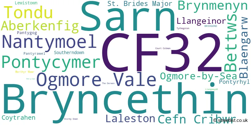
The largest settlement in the CF32 postal code is TONDU followed by OGMORE VALE, and SARN.
The postcode area has a boundary with The Bristol Channel.
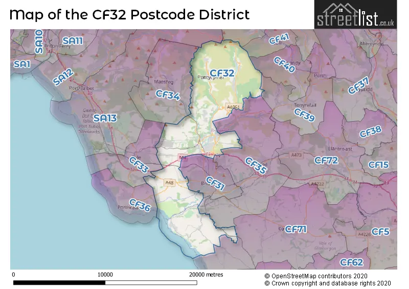
The CF32 Postcode shares a border with CF42 (TREORCHY, Treherbert, CWM-PARC), CF40 (TONYPANDY, TREALAW, PEN-Y-GRAIG), CF31 (BRIDGEND, BRACKLA, BROADLANDS), CF34 (MAESTEG, CAERAU, GARTH), CF35 (PENCOED, COITY, COYCHURCH), CF71 (COWBRIDGE, WICK, LLANBLETHIAN), CF33 (NORTH CORNELLY, KENFIG HILL, PYLE) and SA13 (PORT TALBOT, MARGAM, TAIBACH).
The primary settlement in the CF32 postcode district is Bridgend, which is located in the county of Mid Glamorgan in Wales. Other significant settlements in this district include Aberkenfig, Cefn Cribwr, Coytrahen, Laleston, and Ogmore-by-Sea. The most significant post town in this district is Bridgend.
For the district CF32, we have data on 4 postcode sectors. Here's a breakdown: The sector CF32 0, covers Cefn Cribwr and Laleston in Mid Glamorgan. The sector CF32 0, covers Ogmore-By-Sea and St. Brides Major in South Glamorgan. The sector CF32 7, covers Ogmore Vale and Nantymoel in Mid Glamorgan. The sector CF32 8, covers Pontycymer and Bettws and Blaengarw and Llangeinor in Mid Glamorgan. The sector CF32 9, covers Bryncethin and Sarn and Tondu and Aberkenfig and Brynmenyn in Mid Glamorgan.

Map of the CF32 Postcode District
Explore the CF32 postcode district by using our free interactive map.
When it comes to local government, postal geography often disregards political borders. However, for a breakdown in the CF32 District: the district mostly encompasses the Pen-y-bont ar Ogwr - Bridgend (739 postcodes), and finally, the Bro Morgannwg - the Vale of Glamorgan area (59 postcodes).
Weather Forecast for CF32
Press Button to Show Forecast for Bridgend
| Time Period | Icon | Description | Temperature | Rain Probability | Wind |
|---|---|---|---|---|---|
| 09:00 to 12:00 | Overcast | 7.0°C (feels like 4.0°C) | 10.00% | ENE 13 mph | |
| 12:00 to 15:00 | Cloudy | 9.0°C (feels like 6.0°C) | 6.00% | ENE 13 mph | |
| 15:00 to 18:00 | Cloudy | 10.0°C (feels like 8.0°C) | 9.00% | ENE 13 mph | |
| 18:00 to 21:00 | Cloudy | 10.0°C (feels like 7.0°C) | 6.00% | NE 11 mph | |
| 21:00 to 00:00 | Cloudy | 8.0°C (feels like 5.0°C) | 5.00% | NE 11 mph |
Press Button to Show Forecast for Bridgend
| Time Period | Icon | Description | Temperature | Rain Probability | Wind |
|---|---|---|---|---|---|
| 00:00 to 03:00 | Cloudy | 7.0°C (feels like 5.0°C) | 10.00% | NNE 9 mph | |
| 03:00 to 06:00 | Overcast | 7.0°C (feels like 5.0°C) | 15.00% | N 9 mph | |
| 06:00 to 09:00 | Cloudy | 7.0°C (feels like 4.0°C) | 15.00% | NNW 9 mph | |
| 09:00 to 12:00 | Cloudy | 9.0°C (feels like 6.0°C) | 12.00% | NNW 9 mph | |
| 12:00 to 15:00 | Overcast | 11.0°C (feels like 9.0°C) | 16.00% | WNW 11 mph | |
| 15:00 to 18:00 | Cloudy | 11.0°C (feels like 9.0°C) | 7.00% | W 13 mph | |
| 18:00 to 21:00 | Sunny day | 11.0°C (feels like 8.0°C) | 3.00% | W 13 mph | |
| 21:00 to 00:00 | Clear night | 8.0°C (feels like 6.0°C) | 1.00% | WSW 9 mph |
Press Button to Show Forecast for Bridgend
| Time Period | Icon | Description | Temperature | Rain Probability | Wind |
|---|---|---|---|---|---|
| 00:00 to 03:00 | Clear night | 8.0°C (feels like 6.0°C) | 2.00% | SW 9 mph | |
| 03:00 to 06:00 | Partly cloudy (night) | 7.0°C (feels like 5.0°C) | 2.00% | SSW 9 mph | |
| 06:00 to 09:00 | Cloudy | 8.0°C (feels like 6.0°C) | 5.00% | SSE 9 mph | |
| 09:00 to 12:00 | Partly cloudy (day) | 11.0°C (feels like 8.0°C) | 7.00% | S 13 mph | |
| 12:00 to 15:00 | Light rain | 12.0°C (feels like 10.0°C) | 40.00% | S 16 mph | |
| 15:00 to 18:00 | Partly cloudy (day) | 13.0°C (feels like 10.0°C) | 10.00% | S 16 mph | |
| 18:00 to 21:00 | Light rain shower (day) | 12.0°C (feels like 9.0°C) | 32.00% | SSE 13 mph | |
| 21:00 to 00:00 | Cloudy | 11.0°C (feels like 8.0°C) | 11.00% | SE 13 mph |
Press Button to Show Forecast for Bridgend
| Time Period | Icon | Description | Temperature | Rain Probability | Wind |
|---|---|---|---|---|---|
| 00:00 to 03:00 | Cloudy | 10.0°C (feels like 7.0°C) | 12.00% | SE 13 mph | |
| 03:00 to 06:00 | Cloudy | 10.0°C (feels like 7.0°C) | 12.00% | SE 13 mph | |
| 06:00 to 09:00 | Cloudy | 10.0°C (feels like 7.0°C) | 14.00% | ESE 13 mph | |
| 09:00 to 12:00 | Cloudy | 12.0°C (feels like 9.0°C) | 15.00% | SE 16 mph | |
| 12:00 to 15:00 | Partly cloudy (day) | 13.0°C (feels like 10.0°C) | 13.00% | SE 16 mph | |
| 15:00 to 18:00 | Light rain | 13.0°C (feels like 11.0°C) | 48.00% | SE 13 mph | |
| 18:00 to 21:00 | Overcast | 13.0°C (feels like 11.0°C) | 15.00% | SE 11 mph | |
| 21:00 to 00:00 | Partly cloudy (night) | 11.0°C (feels like 9.0°C) | 7.00% | ESE 9 mph |
Where is the CF32 Postcode District?
The CF32 postcode district is located in Bridgend. It is nearby several towns, including Maesteg to the North West, Porthcawl to the South West, Tonypandy to the North East, Port Talbot to the West, Pontyclun to the East, and Cowbridge to the South East. Additionally, the CF32 postcode district is approximately 149.27 miles away from the center of London.
The district is within the post town of BRIDGEND.
The sector has postcodes within the nation of Wales.
The CF32 Postcode District is covers the following regions.
- Bridgend and Neath Port Talbot - West Wales - Wales
- Cardiff and Vale of Glamorgan - East Wales - Wales
| Postcode Sector | Delivery Office |
|---|---|
| CF32 0 | Bridgend (cf) Delivery Office |
| CF32 7 | Bridgend (cf) Delivery Office |
| CF32 8 | Bridgend (cf) Delivery Office |
| CF32 9 | Bridgend (cf) Delivery Office |
| C | F | 3 | 2 | - | X | X | X |
| C | F | 3 | 2 | Space | Numeric | Letter | Letter |
Current Monthly Rental Prices
| # Bedrooms | Min Price | Max Price | Avg Price |
|---|---|---|---|
| 2 | £775 | £1,950 | £1,167 |
| 3 | £1,295 | £1,350 | £1,323 |
| 4 | £1,495 | £1,600 | £1,548 |
Current House Prices
| # Bedrooms | Min Price | Max Price | Avg Price |
|---|---|---|---|
| 3 | £599,950 | £699,950 | £671,225 |
| 4 | £560,000 | £1,075,000 | £761,350 |
| 5 | £700,000 | £1,200,000 | £843,113 |
| 6 | £670,000 | £1,274,000 | £972,000 |
Estate Agents who Operate in the CF32 District
| Logo | Name | Brand Name | Address | Contact Number | Total Properties |
|---|---|---|---|---|---|
 | Bridgend | Peter Alan | 22 Dunraven Place, Bridgend, CF31 1JD | 01656 331544 | 27 |
 | Bridgend | Payton Jewell Caines | 8 Dunraven Place, Bridgend, CF31 1JD | 01656 331342 | 19 |
 | Bridgend | Herbert R Thomas | The TollHouse, 1 Derwen Road, Bridgend, CF31 1LH | 01656 331130 | 15 |
 | Bridgend | Watts & Morgan | 1 Nolton Street, Bridgend, CF31 1BX | 01656 334904 | 15 |
 | Bridgend | Peter Morgan | 16 Dunraven Place, Bridgend, CF31 1JD | 01656 331489 | 14 |
- Aberkenfig
- Bettws
- Blaengarw
- Bridgend
- Bryncethin
- Brynmenyn
- Castle-upon-Alun
- Cefn Cribwr
- Coytrah�n
- Ffordd-y-Gyfraith
- Fountain
- Hoel-laethog
- L�leston
- Lewistown
- Llangeinor
- Nant-y-moel
- Ogmore-by-Sea
- Ogmore Vale
- Pant-yr-Awel
- Pen-y-fai
- Pitcot
- Pont-y-rhyl
- Pontycymer
- Porthcawl
- Price Town
- Sarn
- Southerndown
- St Brides Major
- St Brides Major / Saint-y-brid
- Tondu
- Tythegston
- Wyndham
- Y Pil
- Y Wig
| Type of Property | 2018 Average | 2018 Sales | 2017 Average | 2017 Sales | 2016 Average | 2016 Sales | 2015 Average | 2015 Sales |
|---|---|---|---|---|---|---|---|---|
| Detached | £300,275 | 128 | £321,085 | 150 | £286,245 | 151 | £265,029 | 154 |
| Semi-Detached | £135,775 | 156 | £138,359 | 189 | £141,638 | 143 | £125,686 | 155 |
| Terraced | £92,796 | 228 | £92,817 | 223 | £83,098 | 209 | £77,958 | 236 |
| Flats | £140,121 | 14 | £189,350 | 17 | £122,929 | 14 | £86,583 | 24 |