
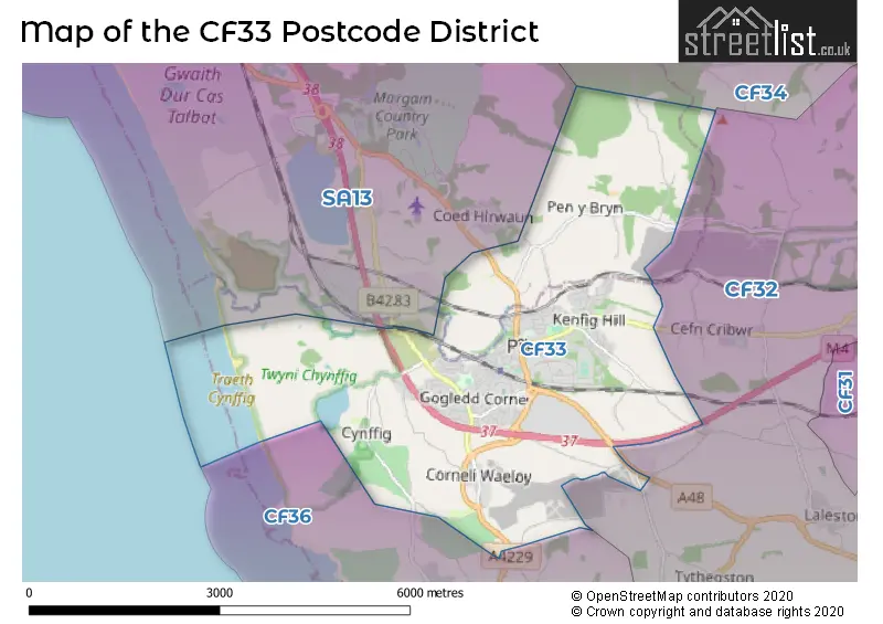
Map of the Postcode District
Explore the postcode district by using our interactive map.
Circles represent recorded crime; the larger the circle, the higher the crime rates.
Your support helps keep this site running!
If you enjoy using this website, consider buying me a coffee to help cover hosting costs.
The postcode district located in the CF Cardiff postal area , CF33 has a population of 14,928 residents according to the 2021 England and Wales Census.
The area of the district is 10.54 square miles (27.31 square kilometers or 6,748.01 acres).
Where is the CF33 District?
To give you an idea where the district is located we have created the following table showing nearby towns.
Nearest Towns to CF33
| Town | Distance (miles) | Direction |
|---|---|---|
| Porthcawl | 3.47 | S |
| Bridgend | 5.27 | ESE |
| Maesteg | 5.70 | NNE |
| Port Talbot | 5.98 | NW |
| Pontycymer | 7.45 | NE |
| Pencoed | 8.43 | E |
| Neath | 10.44 | NNW |
| Cowbridge | 11.69 | ESE |
| Rhondda | 12.13 | NE |
| Treherbert | 12.18 | NE |
| Treorchy | 12.19 | NE |
| Llantwit Major | 12.32 | SE |
| Swansea | 12.33 | WNW |
| Tonypandy | 12.57 | ENE |
| Talbot Green | 13.45 | E |
| Porth | 13.46 | ENE |
| Llantrisant | 13.88 | E |
| Ferndale | 14.05 | NE |
| Pontardawe | 14.90 | NNW |
| Glyn-neath | 15.35 | NNE |
The post town for this district is BRIDGEND.
Postcode Information for District CF33 (Total Geographical Postcodes: 346)
| Location | Post Town | Sector | Number of Postcodes |
|---|---|---|---|
| North Cornelly | BRIDGEND | CF33 4 | 127 |
| Kenfig Hill | BRIDGEND | CF33 6 | 91 |
| Pyle | BRIDGEND | CF33 6 | 79 |
| South Cornelly | BRIDGEND | CF33 4 | 18 |
| Pyle | BRIDGEND | CF33 4 | 17 |
| Maudlam | BRIDGEND | CF33 4 | 6 |
| BRIDGEND | BRIDGEND | CF33 6 | 3 |
| Ton Kenfig | BRIDGEND | CF33 4 | 3 |
| Tranch Pyle | BRIDGEND | CF33 4 | 1 |
| Kenfig | BRIDGEND | CF33 4 | 1 |
Retail and Shopping in CF33
Street
Town
Locality
Number of Shops
Central Postcode
View on Google Maps
BRIDGE STREET
BRIDGEND
KENFIG HILL
18
CF33 6DB
View on Google Maps
COMMERCIAL STREET
BRIDGEND
KENFIG HILL
15
CF33 6DL
View on Google Maps
PISGAH STREET
BRIDGEND
KENFIG HILL
14
CF33 6BU
View on Google Maps
PYLE ROAD
BRIDGEND
PYLE
9
CF33 6PG
View on Google Maps
HEOL FACH
BRIDGEND
NORTH CORNELLY
7
CF33 4LB
View on Google Maps
VILLAGE FARM IND ESTATE
BRIDGEND
PYLE
7
CF33 6NU
View on Google Maps
| Street | Town | Locality | Number of Shops | Central Postcode | View on Google Maps |
|---|---|---|---|---|---|
| BRIDGE STREET | BRIDGEND | KENFIG HILL | 18 | CF33 6DB | View on Google Maps |
| COMMERCIAL STREET | BRIDGEND | KENFIG HILL | 15 | CF33 6DL | View on Google Maps |
| PISGAH STREET | BRIDGEND | KENFIG HILL | 14 | CF33 6BU | View on Google Maps |
| PYLE ROAD | BRIDGEND | PYLE | 9 | CF33 6PG | View on Google Maps |
| HEOL FACH | BRIDGEND | NORTH CORNELLY | 7 | CF33 4LB | View on Google Maps |
| VILLAGE FARM IND ESTATE | BRIDGEND | PYLE | 7 | CF33 6NU | View on Google Maps |
In the CF33 postcode district in Mid Glamorgan, the primary settlement with the highest count is North Cornelly. Other significant settlements include Kenfig Hill, Pyle, South Cornelly, Ton Kenfig, and Tranch Pyle. The post town for this district is Bridgend in Mid Glamorgan.
When it comes to local government, postal geography often disregards political borders. However, this district intersects the following councils: the district mostly encompasses the Pen-y-bont ar Ogwr - Bridgend (303 postal codes), and finally, the Castell-nedd Port Talbot - Neath Port Talbot area (7 postal codes).
The largest settlement in the CF33 postal code is NORTH CORNELLY followed by KENFIG HILL, and PYLE.
The postcode area has a boundary with The Bristol Channel.
The CF33 Postcode shares a border with CF32 (TONDU, OGMORE VALE, SARN), CF36 (PORTHCAWL, Nottage, NEWTON) and SA13 (PORT TALBOT, MARGAM, TAIBACH).


Stations in the Sector
Pyle
CRS Code: PYL
Operator: AW
Line: South Wales Main Line
Company: Transport for Wales
Accessable Motorway Junctions
M4 J37
Average Driving Time from within the district: 2.69
Average Driving Distance: 1.44
Number of Postcodes that can access the Motorway Junction: 311
M4 J38
Average Driving Time from within the district: 5.92
Average Driving Distance: 3.77
Number of Postcodes that can access the Motorway Junction: 311
M4 J35
Average Driving Time from within the district: 6.31
Average Driving Distance: 3.60
Number of Postcodes that can access the Motorway Junction: 2
M4 J39
Average Driving Time from within the district: 7.24
Average Driving Distance: 4.89
Number of Postcodes that can access the Motorway Junction: 311
M4 J36
Average Driving Time from within the district: 7.91
Average Driving Distance: 6.50
Number of Postcodes that can access the Motorway Junction: 305
M4 J40
Average Driving Time from within the district: 8.84
Average Driving Distance: 6.85
Number of Postcodes that can access the Motorway Junction: 309
M4 J41
Average Driving Time from within the district: 10.34
Average Driving Distance: 7.07
Number of Postcodes that can access the Motorway Junction: 6
Weather Forecast for Pyle
| Time Period | Icon | Description | Temperature | Rain Probability | Wind |
|---|---|---|---|---|---|
| 12:00 to 15:00 | Partly cloudy (day) | 14.0°C (feels like 13.0°C) | 3.00% | W 9 mph | |
| 15:00 to 18:00 | Sunny day | 14.0°C (feels like 12.0°C) | 1.00% | W 11 mph | |
| 18:00 to 21:00 | Cloudy | 13.0°C (feels like 13.0°C) | 5.00% | WSW 4 mph | |
| 21:00 to 00:00 | Partly cloudy (night) | 13.0°C (feels like 12.0°C) | 3.00% | S 4 mph |
| Time Period | Icon | Description | Temperature | Rain Probability | Wind |
|---|---|---|---|---|---|
| 00:00 to 03:00 | Partly cloudy (night) | 12.0°C (feels like 11.0°C) | 3.00% | SE 7 mph | |
| 03:00 to 06:00 | Partly cloudy (night) | 12.0°C (feels like 10.0°C) | 1.00% | SE 9 mph | |
| 06:00 to 09:00 | Partly cloudy (night) | 11.0°C (feels like 10.0°C) | 2.00% | SE 7 mph | |
| 09:00 to 12:00 | Partly cloudy (day) | 12.0°C (feels like 11.0°C) | 1.00% | SE 7 mph | |
| 12:00 to 15:00 | Partly cloudy (day) | 14.0°C (feels like 13.0°C) | 2.00% | SSE 9 mph | |
| 15:00 to 18:00 | Partly cloudy (day) | 15.0°C (feels like 14.0°C) | 7.00% | SSE 7 mph | |
| 18:00 to 21:00 | Partly cloudy (night) | 14.0°C (feels like 12.0°C) | 2.00% | SSE 11 mph | |
| 21:00 to 00:00 | Clear night | 12.0°C (feels like 10.0°C) | 1.00% | SE 11 mph |
| Time Period | Icon | Description | Temperature | Rain Probability | Wind |
|---|---|---|---|---|---|
| 00:00 to 03:00 | Partly cloudy (night) | 12.0°C (feels like 10.0°C) | 1.00% | SE 13 mph | |
| 03:00 to 06:00 | Partly cloudy (night) | 13.0°C (feels like 10.0°C) | 1.00% | SE 13 mph | |
| 06:00 to 09:00 | Partly cloudy (night) | 13.0°C (feels like 10.0°C) | 1.00% | SE 16 mph | |
| 09:00 to 12:00 | Cloudy | 14.0°C (feels like 11.0°C) | 6.00% | SE 16 mph | |
| 12:00 to 15:00 | Partly cloudy (day) | 15.0°C (feels like 12.0°C) | 8.00% | SE 18 mph | |
| 15:00 to 18:00 | Cloudy | 15.0°C (feels like 12.0°C) | 19.00% | SE 18 mph | |
| 18:00 to 21:00 | Light rain | 15.0°C (feels like 13.0°C) | 58.00% | SSE 13 mph | |
| 21:00 to 00:00 | Heavy rain shower (night) | 14.0°C (feels like 11.0°C) | 64.00% | SSW 16 mph |
| Time Period | Icon | Description | Temperature | Rain Probability | Wind |
|---|---|---|---|---|---|
| 00:00 to 03:00 | Light rain shower (night) | 13.0°C (feels like 11.0°C) | 43.00% | SW 16 mph | |
| 03:00 to 06:00 | Light rain shower (night) | 12.0°C (feels like 10.0°C) | 33.00% | SW 13 mph | |
| 06:00 to 09:00 | Light rain shower (night) | 12.0°C (feels like 9.0°C) | 32.00% | SW 13 mph | |
| 09:00 to 12:00 | Light rain shower (day) | 11.0°C (feels like 9.0°C) | 32.00% | SW 13 mph | |
| 12:00 to 15:00 | Light rain shower (day) | 12.0°C (feels like 9.0°C) | 37.00% | W 16 mph | |
| 15:00 to 18:00 | Partly cloudy (day) | 12.0°C (feels like 9.0°C) | 11.00% | W 18 mph | |
| 18:00 to 21:00 | Clear night | 11.0°C (feels like 8.0°C) | 5.00% | W 16 mph | |
| 21:00 to 00:00 | Clear night | 11.0°C (feels like 8.0°C) | 5.00% | W 16 mph |
| Time Period | Icon | Description | Temperature | Rain Probability | Wind |
|---|---|---|---|---|---|
| 00:00 to 03:00 | Partly cloudy (night) | 11.0°C (feels like 8.0°C) | 8.00% | W 16 mph | |
| 03:00 to 06:00 | Cloudy | 11.0°C (feels like 8.0°C) | 16.00% | W 16 mph | |
| 06:00 to 09:00 | Light rain shower (night) | 11.0°C (feels like 8.0°C) | 36.00% | W 16 mph | |
| 09:00 to 12:00 | Cloudy | 12.0°C (feels like 9.0°C) | 23.00% | WSW 16 mph | |
| 12:00 to 15:00 | Light rain shower (day) | 13.0°C (feels like 10.0°C) | 40.00% | WSW 18 mph | |
| 15:00 to 18:00 | Light rain shower (day) | 13.0°C (feels like 10.0°C) | 44.00% | WSW 18 mph | |
| 18:00 to 21:00 | Light rain shower (night) | 13.0°C (feels like 10.0°C) | 37.00% | W 16 mph | |
| 21:00 to 00:00 | Clear night | 13.0°C (feels like 10.0°C) | 12.00% | W 16 mph |
| Postal Sector | Delivery Office |
|---|---|
| CF33 4 | Bridgend (cf) Delivery Office |
| CF33 6 | Bridgend (cf) Delivery Office |
| C | F | 3 | 3 | - | X | X | X |
| C | F | 3 | 3 | Space | Numeric | Letter | Letter |
Street List for the CF33 District
Current Monthly Rental Prices
| # Bedrooms | Min Price | Max Price | Avg Price |
|---|
Current House Prices
| # Bedrooms | Min Price | Max Price | Avg Price |
|---|---|---|---|
| £200,000 | £200,000 | £200,000 | |
| 2 | £215,000 | £215,000 | £215,000 |
| 3 | £200,000 | £425,000 | £263,889 |
| 4 | £225,000 | £385,000 | £287,595 |
| 5 | £400,000 | £925,000 | £543,750 |
Estate Agents
| Logo | Name | Brand Name | Address | Contact Number |
|---|---|---|---|---|
 | Porthcawl | Peter Alan | 58 John Street, Porthcawl, CF36 3BD | 01656 335073 |
 | Kenfig Hill | Ferriers Estate Agents | 41a Bridge Street, Kenfig Hill, CF33 6DB | 01656 330512 |
 | Porthcawl | Prestons | 16 Lias Road, Porthcawl, CF36 3AH | 01656 338835 |
 | Wales | eXp UK | 1 Northumberland Avenue, Trafalgar Square, London, WC2N 5BW | 03304 609968 |
 | Porthcawl | Thompsons Estate Agents | 69 John Street, Porthcawl, CF36 3AY | 01656 331502 |
Yearly House Price Averages for the District
| Type of Property | 2018 Average | 2018 Sales | 2017 Average | 2017 Sales | 2016 Average | 2016 Sales | 2015 Average | 2015 Sales |
|---|---|---|---|---|---|---|---|---|
| Detached | £212,354 | 46 | £199,665 | 42 | £189,061 | 48 | £180,615 | 47 |
| Semi-Detached | £136,301 | 90 | £125,564 | 76 | £125,118 | 86 | £117,136 | 107 |
| Terraced | £105,981 | 66 | £109,629 | 66 | £102,388 | 60 | £104,712 | 70 |
| Flats | £61,968 | 17 | £67,708 | 12 | £61,650 | 10 | £68,139 | 19 |