This section of the site is all about the SA Postcode area, also known as the Swansea Postal Area. Explore links to the next level to learn more about specific postcode districts such as SA1.
The SA postcode area represents a group of postal districts in the Swansea area of the United Kingdom. The area code SA stands for the letters s and a in SwanseA. SA has a population of 730,232 and covers an area of 5,664,082 hectares. Fun fact: 1.12% of the population of Great Britain lives in this area.
The postcode area falls within the following counties: Dyfed (55.68%), West Glamorgan (42.75%), Powys (1.56%), Mid Glamorgan (0.01%).
Post Towns and Postcode Districts for the SA Postcode
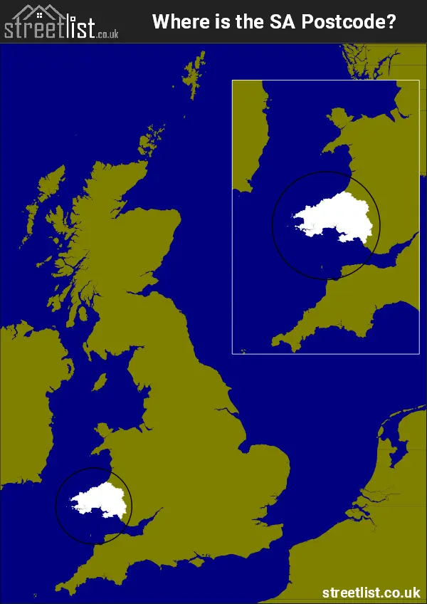
Where is the SA Postcode Area?
The SA Swansea Postcode is in Wales The postal area borders the following neighbouring postal areas: LD - Llandrindod Wells, SY - Shrewsbury and CF - Cardiff, It also borders Saint Brides Bay, St Georges Channel, Cardigan Bay, Milford Haven and The Bristol Channel.
Map of the SA Swansea Postcode Area
Explore the SA Swansea postcode area by using our interactive map.
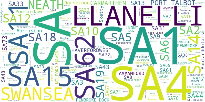
Postcode Districts within the SA Swansea Postcode Area
There are 51 postcode districts within the Swansea postcode area
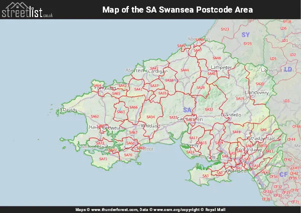
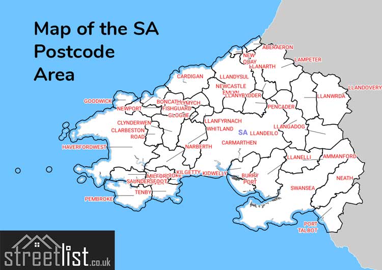
A map showing the boundary of in relation to other areas
There are 34 towns within the Swansea postcode area.
- Aberdaugleddau / Milford Haven
- Abergwaun / Fishguard
- Aberteifi / Cardigan
- Ammanford
- Arberth / Narberth
- Burry Port / Porth Tywyn
- Carmarthen
- Casllwchwr / Loughor
- Cydweli / Kidwelly
- Dinbych-y-Pysgod / Tenby
- Doc Penfro / Pembroke Dock
- Glyn-nedd / Glyn-neath
- Gorseinon
- Haverfordwest
- Hendy-Gwyn / Whitland
- Llanbedr Pont Steffan / Lampeter
- Llandeilo
| Unit | Area² |
|---|---|
| Hectares | 5,664,082² |
| Miles | 21,869² |
| Feet | 609,676,122,398² |
| Kilometres | 56,641² |
Postal Delivery Offices serving the SA Swansea Postcode Area
- Ammanford Delivery Office
- Cardigan Delivery Office
- Carmarthen Delivery Office
- Fishguard Delivery Office
- Gorseinon Delivery Office
- Haverfordwest Delivery Office
- Kidwelly Scale Payment Delivery Office
- Lampeter Delivery Office
- Llandeilo Delivery Office
- Llandovery Delivery Office
- Llandysul Delivery Office
- Llanelli Delivery Office
- Milford Haven Delivery Office
- Mumbles Delivery Office
- Narberth Delivery Office
- Neath Delivery Office
- Pembroke Dock Delivery Office
- Pontardawe Delivery Office
- Port Talbot Delivery Office
- Swansea Delivery Office
- Tenby Delivery Office
- Whitland Delivery Office
- Ystalyfera Delivery Office
Councils with Postcodes in SA
Towns and Villages within the SA Swansea Postcode Area
- Aber-banc - village
- Aberarth - village
- Abercraf - village
- Abercregan - village
- Abercych - village
- Aberdaugleddau / Milford Haven - town
- Aberdulais - village
- Abergarwed - village
- Abergorlech - village
- Abergwaun / Fishguard - town
- Abergwili - village
- Abergwynfi - village
- Aberporth - village
- Abertawe / Swansea - city
- Aberteifi / Cardigan - town
- Allt - village
- Alltwen - village
- Alltyblaca - village
- Ammanford - town
- Amroth - village
- Angle - village
- Arberth / Narberth - town
- Ashfield - village
- Baglan - village
- Bancffosfelen - village
- Bancyfelin - village
- Banwen - village
- Begelly - village
- Beulah - village
- Blaenannerch - village
- Blaenau - village
- Blaenffos - village
- Blaengwrach - village
- Blaengwynfi - village
- Blaenporth - village
- Blue Anchor - village
- Boncath - village
- Bosherston - village
- Brawdy - village
- Brechfa - village
- Briton Ferry / Llansawel - Settlement
- Broad Haven - village
- Broadmoor - village
- Broadway - village
- Bronwydd - village
- Bronwydd Arms - village
- Bryn - village
- Bryn - village
- Brynamman - village
- Brynhoffnant - village
- Brynhyfryd - village
- Burry Port / Porth Tywyn - town
- Burton - village
- Burton Ferry - village
- Cae'r-bryn - village
- Caehopkin - village
- Caeo - village
- Caerwedros - village
- Camrose - village
- Capel Dewi - otherSettlement
- Capel Dewi - village
- Capel Hendre - village
- Capel Iwan - village
- Carew - village
- Carmarthen - town
- Carmel - village
- Carway - village
- Casllwchwr / Loughor - town
- Castlemartin - village
- Castlemorris - village
- Caswell - village
- Cefn-bryn-brain - village
- Cefneithin - village
- Cellan - village
- Cenarth - village
- Cilcennin - village
- Cilfrew - village
- Cilgerran - village
- Ciliau Aeron - village
- Cilycwm - village
- Clarbeston Road - village
- Clunderwen - village
- Clydach - Settlement
- Clyne - village
- Coed-y-bryn - village
- Coedhirwaun - village
- Coelbren - village
- Cold Blow - village
- Coopers - village
- Cosheston - village
- Court Henry - village
- Craig-cefn-parc - village
- Cresselly - village
- Cribyn - village
- Croes-goch - village
- Croes-lan - village
- Croeserw - village
- Crofty - village
- Cross Hands - village
- Cross Inn - village
- Crundale - village
- Crwbin - village
- Crymych - village
- Crynant - village
- Cwm-cou - village
- Cwm-twrch Isaf - village
- Cwm-twrch Uchaf - village
- Cwm-y-glo - village
- Cwmann - village
- Cwmavon - village
- Cwmduad - village
- Cwmffrwd - village
- Cwmgors - village
- Cwmgwili - village
- Cwmgwrach - village
- Cwmifor - village
- Cwmllynfell - village
- Cwmpengraig - village
- Cwrtnewydd - village
- Cydweli / Kidwelly - town
- Cymer - village
- Cynghordy - village
- Cynheidre - village
- Cynwyl Elfed - village
- Dale - village
- Derwydd - village
- Dihewyd - village
- Dinas Cross - village
- Dinbych-y-Pysgod / Tenby - town
- Doc Penfro / Pembroke Dock - town
- Dre-fach - village
- Drefach - village
- Drefach - village
- Drefelin - village
- Duffryn - village
- Dunvant - village
- Dyffryn Cellwen - village
- Dyffryn Clydach - village
- East Williamston - village
- Efail-foch - village
- Efailwen - village
- Eglwys Nunydd - village
- Eglwyswrw - village
- Felindre - village
- Felindre - village
- Felindre - village
- Felinfach - village
- Ferryside - village
- Ffairfach - village
- Ffarmers - village
- Fforest - village
- Ffos-y-ffon - village
- Ffostrasol - village
- Foelgastell - village
- Ford - village
- Four Roads - village
- Freshwater East - village
- Freystrop - village
- Garnant - village
- Gellinudd - village
- Gilfachreda - village
- Glais - village
- Glan-rhyd - village
- Glanaman - village
- Glandy Cross - village
- Glyn-nedd / Glyn-neath - town
- Glyncorrwg - village
- Golden Grove - village
- Gorof - village
- Gorseinon - town
- Gorsgoch - village
- Gorslas - village
- Goytre - village
- Grovesend - village
- Gwaun-Cae-Gurwen - village
- Gwernogle - otherSettlement
- Gwyddgrug - village
- Haverfordwest - town
- Hendy - village
- Hendy-Gwyn / Whitland - town
- Henfynyw - village
- Henllan - village
- Heol-ddu - village
- Herbrandston - village
- Hermon - village
- Hill - village
- Hill Mountain - village
- Hook - village
- Horeb - village
- Horton - village
- Houghton - village
- Hundleton - village
- Idole - village
- Jameston - village
- Jeffreyston - village
- Jersey Marine - village
- Johnston - village
- Keeston - village
- Kilgetty / Cilgeti - village
- Kingsmoor - village
- Kittle - village
- Lampeter Velfrey - village
- Lawrenny - village
- Letterston / Treletert - village
- Little Haven - village
- Llanarth - village
- Llanarthne - village
- Llanbedr Pont Steffan / Lampeter - town
- Llanboidy - village
- Llandarcy - village
- Llanddarog - village
- Llanddewi Felffre / Llanddewi Velfrey - village
- Llanddowror - village
- Llandeilo - town
- Llandeilo Ferwallt / Bishopston - village
- Llandissilio - village
- Llandudoch / St Dogmaels - village
- Llandybie - village
- Llandyfaelog - village
- Llandyfai / Lamphey - village
- Llandygwydd - village
- Llandysul - town
- Llanedi - village
- Llanelli - town
- Llanfair Clydogau - village
- Llanfihangel-ar-arth - village
- Llangadog - village
- Llangain - village
- Llangendeirne / Llangyndeyrn - village
- Llangennech - village
- Llangennith - village
- Llangoedmor - village
- Llangrannog - village
- Llangunnor - village
- Llangwm - village
- Llangybi - village
- Llangynin - village
- Llangynog - village
- Llanllwch - village
- Llanllwni - village
- Llanmadoc - village
- Llanmiloe - village
- Llanmorlais - village
- Llannon - village
- Llanpumsaint - village
- Llanrhidian - village
- Llansadwrn - village
- Llansaint - village
- Llansawel - village
- Llanstadwell - village
- Llansteffan - village
- Llanteg - village
- Llanwnnen - village
- Llanwrda - village
- Llanybri - village
- Llanybydder / Llanybyther - town
- Llanymddyfri / Llandovery - town
- Llawhaden - village
- Llechryd - village
- Llwyncelyn - village
- Llwyndafydd - village
- Login - village
- Lon y Felin - village
- Ludchurch - village
- Lydstep - village
- Maen-y-groes - village
- Maenclochog - village
- Maenorbyr / Manorbier - village
- Maesycrugiau - otherSettlement
- Maiden Wells - village
- Manordeilo - village
- Manselfield - village
- Marloes - village
- Martletwy - village
- Mascle Bridge - village
- Mathri / Mathry - village
- Meidrim - village
- Meinciau - village
- Melincourt - village
- Merlin's Bridge - village
- Merrion - otherSettlement
- Milo - village
- Milton - village
- Morfa - village
- Murton - village
- Myddfai - village
- Mydroilyn - village
- Mynachlog-ddu - village
- Mynydd Cerrig - village
- Mynyddygarreg - village
- Nant-y-cafn - village
- Nantgaredig - village
- Nantycaws - village
- Neath / Castell-nedd - town
- New Hedges - village
- New Inn - village
- New Moat - village
- New Quay / Ceinewydd - town
- Newcastle Emlyn / Castell Newydd Emlyn - town
- Newton Mountain - village
- Neyland - town
- Nolton Haven - village
- Onllwyn - village
- Parcllyn - village
- Pelcomb Cross - village
- Pembrey / Pen-bre - village
- Pen-clawdd - village
- Pen-Rhiw-fawr - village
- Pen-y-banc - village
- Pen-y-bryn - village
- Pen-y-cae - village
- Pen-y-groes - village
- Penalum / Penally - village
- Pencader - village
- Pencarreg - village
- Penfro / Pembroke - town
- Peniel - village
- Penllergaer - village
- Penmaen - village
- Penparc - village
- Penrhiw-llan - village
- Pentlepoir - village
- Pentre Galar - otherSettlement
- Pentre-cwrt - village
- Pentrecagal - village
- Pentrellwyn - village
- Pentywyn / Pendine - village
- Penybanc - village
- Penycwm - village
- Pleasant Valley - village
- Plwmp - village
- Pont Henri - village
- Pont-ar-gothi - village
- Pont-iets / Pontyates - village
- Pont-Son - village
- Pont-Tyweli - village
- Pont-yr-hafod - village
- Pontardawe - town
- Pontarddulais - town
- Pontfaen - otherSettlement
- Pontgarreg - village
- Pontlliw - village
- Pontneddfechan - village
- Pontrhydyfen - village
- Pontyberem - village
- Port Talbot - town
- Port-Eynon - village
- Porthgain - village
- Porthyrhyd - village
- Pren-gwyn - village
- Pum Heol / Five Roads - village
- Pumsaint - otherSettlement
- Puncheston - village
- Pwll - village
- Pwll-trap - village
- Pyle - village
- Ram - village
- Redberth - village
- Resolfen / Resolven - village
- Reynalton - village
- Reynoldston - village
- Rhandirmwyn - village
- Rhos - village
- Rhos - village
- Rhosaman - village
- Rhosmaen - village
- Rhossili - village
- Rhyd-y-gwin - village
- Rhydargaeau - village
- Rhydcymerau - village
- Rhydlewis - village
- Rhydowen - village
- Robeston Wathen - village
- Roch - village
- Rosebush - village
- Rosemarket - village
- Sageston - village
- Salem - village
- Sardis - village
- Sarnau - village
- Saron - village
- Saron - village
- Saundersfoot - village
- Scleddau - village
- Scurlage - village
- Seven Sisters / Blaendulais - village
- Silian - village
- Simpson Cross - village
- Solfach / Solva - village
- Southgate - village
- Spittal - village
- Square and Compass - village
- St Clears - town
- St Davids - city
- St Florence - village
- St Ishmael's - village
- St Twynnells - village
- Stackpole - village
- Stepaside - village
- Summerhill - village
- Tairgwaith - village
- Tal-sarn - village
- Talacharn / Laugharne - town
- Talgarreg - village
- Talog - village
- Talyllychau / Talley - village
- Tan-y-groes - village
- Tavernspite - village
- Tegryn - village
- Temple Bar - village
- Templeton - village
- The Gate / Castell-y-rhingyll - village
- Thornton - village
- Three Crosses - village
- Tiers Cross - village
- Tircoed - village
- Tonmawr - village
- Tonna - village
- Trapp - otherSettlement
- Tre-Forgan - village
- Tre-gwyr / Gowerton - village
- Trebannws / Trebanos - village
- Trecwn - village
- Trefdraeth / Newport - town
- Trefgarn Owen - village
- Trefin / Trevine - village
- Treherbert - village
- Trelech - village
- Tresaith - village
- Trevaughan - village
- Trimsaran - village
- Tycroes - village
- Tyn-y-cwm - village
- Upper Killay - village
- Walton East - village
- Waterston - village
- Waun y Clyn - village
- Waunarlwydd - village
- Waungilwen - village
- Wdig / Goodwick - town
- Wiston - village
- Wolf's Castle - village
- Wooden - village
- Y Ferwig - village
- Y Gurnos / Gurnos - village
- Y Tymbl / Tumble - village
- Ynyswen - village
- Ystalyfera - village
- Ystrad Aeron - village
- Ystradgynlais - town
- Ystradowen - village