The SA37 postcode district is a postal district located in the SA Swansea postcode area with a population of 1,409 residents according to the 2021 England and Wales Census.
The area of the SA37 postcode district is 18.63 square miles which is 48.26 square kilometres or 11,924.80 acres.
Currently, the SA37 district has about 57 postcode units spread across 1 geographic postcode sectors.
Given that each sector allows for 400 unique postcode combinations, the district has a capacity of 400 postcodes. With 57 postcodes already in use, this leaves 343 units available.
The largest settlement in the SA37 postal code is Blaenffos followed by BONCATH, and NEWCHAPEL.
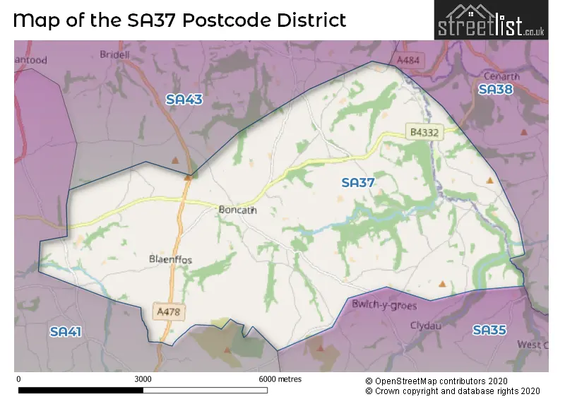
The SA37 Postcode shares a border with SA35 (TEGRYN, LLANFYRNACH, CILRHEDYN), SA41 (CRYMYCH, EGLWYSWRW, FELINDRE FARCHOG) and SA43 (CARDIGAN, ABERPORTH, ST DOGMAELS).
In the SA37 postcode district in Dyfed, the primary settlement is Boncath, which has the highest count. Other significant settlements in the district include Abercych, Blaenffos, Lancych, Newchapel, and Pontselli. The most significant post town in the district is Boncath.
For the district SA37, we have data on 1 postcode sectors. Here's a breakdown: The sector SA37 0, covers Boncath and Blaenffos and Abercych and Newchapel in Dyfed.
SA37 Postcode Sectors

Map of the SA37 Postcode District
Explore the SA37 postcode district by using our free interactive map.
When it comes to local government, postal geography often disregards political borders. However, for a breakdown in the SA37 District: the district mostly encompasses the Sir Benfro - Pembrokeshire (56 postcodes), and finally, the Sir Gaerfyrddin - Carmarthenshire area (3 postcodes).
Recent House Sales in SA37
| Date | Price | Address |
|---|---|---|
| 28/06/2023 | £250,000 | Abercych, Boncath, SA37 0EZ |
| 26/05/2023 | £129,000 | Boncath, SA37 0HR |
| 28/04/2023 | £375,000 | Cwrt Dolwerdd, Boncath, SA37 0JQ |
| 16/12/2022 | £320,000 | Boncath, SA37 0JW |
| 12/12/2022 | £445,000 | Boncath, SA37 0JL |
| 29/11/2022 | £161,000 | Porth Street, Abercych, Boncath, SA37 0EY |
| 18/11/2022 | £250,000 | Cwrt Dolwerdd, Boncath, SA37 0JQ |
| 28/10/2022 | £240,000 | Abercych, Boncath, SA37 0HA |
| 18/10/2022 | £350,000 | Cwrt Dolwerdd, Boncath, SA37 0JQ |
| 07/10/2022 | £245,000 | Cwrt Dolwerdd, Boncath, SA37 0JQ |
Where is the SA37 Postcode District?
The postcode district SA37 is located in the town of Boncath. Boncath is surrounded by several nearby towns. To the south, there is Glogue, which is approximately 3.4 miles away. To the southwest, there is Crymych, which is around 3.8 miles away. Moving east, we find Newcastle Emlyn at a distance of approximately 5.5 miles. In the northwestern direction, we have Cardigan, which is around 5.5 miles away. To the west, we find Newport, which is approximately 10.2 miles away. Finally, in the northeast, we find Llandysul at a distance of around 11.6 miles. Furthermore, the distance from the postcode district SA37 to the center of London is approximately 194.7 miles.
The district is within the post town of BONCATH.
The sector has postcodes within the nation of Wales.
The SA37 Postcode District is in the South West Wales region of West Wales within the Wales.
Weather Forecast for SA37
Press Button to Show Forecast for Foel Drygarn
| Time Period | Icon | Description | Temperature | Rain Probability | Wind |
|---|---|---|---|---|---|
| 15:00 to 18:00 | Partly cloudy (day) | 17.0°C (feels like 15.0°C) | 5.00% | SSW 11 mph | |
| 18:00 to 21:00 | Partly cloudy (day) | 14.0°C (feels like 13.0°C) | 2.00% | WSW 7 mph | |
| 21:00 to 00:00 | Cloudy | 10.0°C (feels like 7.0°C) | 6.00% | SSW 11 mph |
Press Button to Show Forecast for Foel Drygarn
| Time Period | Icon | Description | Temperature | Rain Probability | Wind |
|---|---|---|---|---|---|
| 00:00 to 03:00 | Cloudy | 10.0°C (feels like 7.0°C) | 8.00% | S 16 mph | |
| 03:00 to 06:00 | Overcast | 10.0°C (feels like 7.0°C) | 17.00% | S 16 mph | |
| 06:00 to 09:00 | Overcast | 10.0°C (feels like 6.0°C) | 15.00% | SSE 22 mph | |
| 09:00 to 12:00 | Cloudy | 10.0°C (feels like 6.0°C) | 54.00% | SSE 27 mph | |
| 12:00 to 15:00 | Heavy rain | 11.0°C (feels like 7.0°C) | 88.00% | SE 29 mph | |
| 15:00 to 18:00 | Heavy rain | 12.0°C (feels like 7.0°C) | 91.00% | SE 29 mph | |
| 18:00 to 21:00 | Heavy rain | 11.0°C (feels like 8.0°C) | 91.00% | SSE 22 mph | |
| 21:00 to 00:00 | Heavy rain | 10.0°C (feels like 8.0°C) | 89.00% | S 13 mph |
Press Button to Show Forecast for Foel Drygarn
| Time Period | Icon | Description | Temperature | Rain Probability | Wind |
|---|---|---|---|---|---|
| 00:00 to 03:00 | Cloudy | 10.0°C (feels like 7.0°C) | 37.00% | SSE 9 mph | |
| 03:00 to 06:00 | Cloudy | 9.0°C (feels like 7.0°C) | 17.00% | SE 9 mph | |
| 06:00 to 09:00 | Cloudy | 9.0°C (feels like 7.0°C) | 14.00% | E 9 mph | |
| 09:00 to 12:00 | Cloudy | 11.0°C (feels like 8.0°C) | 19.00% | ESE 11 mph | |
| 12:00 to 15:00 | Light rain shower (day) | 12.0°C (feels like 10.0°C) | 41.00% | ESE 11 mph | |
| 15:00 to 18:00 | Light rain shower (day) | 13.0°C (feels like 11.0°C) | 41.00% | SE 11 mph | |
| 18:00 to 21:00 | Light rain shower (day) | 12.0°C (feels like 10.0°C) | 37.00% | ESE 11 mph | |
| 21:00 to 00:00 | Clear night | 10.0°C (feels like 7.0°C) | 6.00% | ESE 11 mph |
Press Button to Show Forecast for Foel Drygarn
| Time Period | Icon | Description | Temperature | Rain Probability | Wind |
|---|---|---|---|---|---|
| 00:00 to 03:00 | Partly cloudy (night) | 9.0°C (feels like 6.0°C) | 6.00% | ESE 13 mph | |
| 03:00 to 06:00 | Cloudy | 9.0°C (feels like 6.0°C) | 9.00% | ESE 13 mph | |
| 06:00 to 09:00 | Cloudy | 10.0°C (feels like 7.0°C) | 6.00% | ESE 13 mph | |
| 09:00 to 12:00 | Partly cloudy (day) | 12.0°C (feels like 9.0°C) | 9.00% | ESE 16 mph | |
| 12:00 to 15:00 | Light rain shower (day) | 13.0°C (feels like 11.0°C) | 33.00% | ESE 13 mph | |
| 15:00 to 18:00 | Light rain shower (day) | 13.0°C (feels like 12.0°C) | 39.00% | ESE 11 mph | |
| 18:00 to 21:00 | Light rain shower (day) | 13.0°C (feels like 11.0°C) | 36.00% | S 9 mph | |
| 21:00 to 00:00 | Clear night | 10.0°C (feels like 8.0°C) | 4.00% | SW 9 mph |
Press Button to Show Forecast for Foel Drygarn
| Time Period | Icon | Description | Temperature | Rain Probability | Wind |
|---|---|---|---|---|---|
| 00:00 to 03:00 | Clear night | 8.0°C (feels like 6.0°C) | 4.00% | S 9 mph | |
| 03:00 to 06:00 | Clear night | 8.0°C (feels like 6.0°C) | 4.00% | SSW 9 mph | |
| 06:00 to 09:00 | Sunny day | 9.0°C (feels like 7.0°C) | 2.00% | ESE 9 mph | |
| 09:00 to 12:00 | Sunny day | 12.0°C (feels like 11.0°C) | 4.00% | S 9 mph | |
| 12:00 to 15:00 | Partly cloudy (day) | 14.0°C (feels like 13.0°C) | 8.00% | WNW 7 mph | |
| 15:00 to 18:00 | Light rain shower (day) | 13.0°C (feels like 12.0°C) | 31.00% | W 7 mph | |
| 18:00 to 21:00 | Partly cloudy (day) | 12.0°C (feels like 11.0°C) | 6.00% | WNW 9 mph | |
| 21:00 to 00:00 | Partly cloudy (night) | 9.0°C (feels like 7.0°C) | 2.00% | NNW 9 mph |
Postcode Sectors within the SA37 District
| Postcode Sector | Delivery Office |
|---|---|
| SA37 0 | Cardigan Delivery Office |
| S | A | 3 | 7 | - | X | X | X |
| S | A | 3 | 7 | Space | Numeric | Letter | Letter |
Current Monthly Rental Prices
| # Bedrooms | Min Price | Max Price | Avg Price |
|---|
Current House Prices
| # Bedrooms | Min Price | Max Price | Avg Price |
|---|---|---|---|
| £200,000 | £200,000 | £200,000 | |
| 2 | £135,000 | £225,000 | £180,000 |
| 3 | £195,000 | £1,750,000 | £462,205 |
| 4 | £525,000 | £525,000 | £525,000 |
| 5 | £445,000 | £445,000 | £445,000 |
Estate Agents who Operate in the SA37 District
| Logo | Name | Brand Name | Address | Contact Number | Total Properties |
|---|---|---|---|---|---|
 | Cardigan | JJ Morris | 5 High Street, Cardigan, SA43 1HJ | 01234 860635 | 5 |
 | Cardigan | John Francis | 20 High Street Cardigan SA43 1JJ | 01239 801755 | 4 |
 | Cardiff | Savills | 2 Kingsway Cardiff CF10 3FD | 029 2271 0472 | 1 |
 | Cardigan | West Wales Properties | 41 High Street, Cardigan, Ceredigion, SA43 1JG | 01239 803032 | 1 |
 | Nationwide | Springbok Properties | Springbok Properties Nationwide Suite 7N Trafford House Chester Road Old Trafford M32 0RS | 0161 416 6302 | 1 |
Yearly House Price Averages for the SA37 Postcode District
| Type of Property | 2018 Average | 2018 Sales | 2017 Average | 2017 Sales | 2016 Average | 2016 Sales | 2015 Average | 2015 Sales |
|---|---|---|---|---|---|---|---|---|
| Detached | £218,778 | 11 | £204,700 | 15 | £239,786 | 21 | £273,883 | 9 |
| Semi-Detached | £114,000 | 3 | £122,500 | 2 | £196,250 | 5 | £127,983 | 3 |
| Terraced | £101,625 | 4 | £116,363 | 4 | £73,750 | 2 | £155,000 | 1 |
| Flats | £0 | 0 | £0 | 0 | £0 | 0 | £0 | 0 |