This section of the site is all about the SY Postcode area, also known as the Shrewsbury Postal Area. Explore links to the next level to learn more about specific postcode districts such as SY1.
The SY postcode area represents a group of postal districts in the Shrewsbury area of the United Kingdom. The area code SY stands for the letters s and y in Shrewsbury. SY has a population of 342,140 and covers an area of 6,067,463 hectares. Fun fact: 0.53% of the population of Great Britain lives in this area.
The postcode area falls within the following counties: Shropshire (63.25%), Powys (21.08%), Dyfed (9.95%), Cheshire (2.57%), Herefordshire (1.20%), Clwyd (1.02%), Gwynedd (0.91%), Worcestershire (0.01%).
Post Towns and Postcode Districts for the SY Postcode
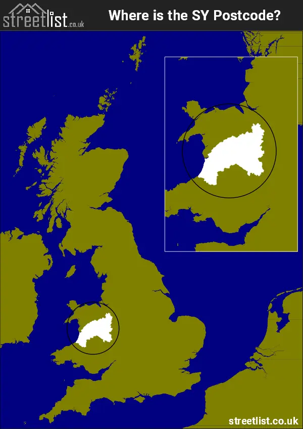
Where is the SY Postcode Area?
The SY Shrewsbury Postcode has it's West in Wales and it's East is in the West Midlands of England. The postal area borders the following neighbouring postal areas: TF - Telford, LL - Llandudno, CW - Crewe, LD - Llandrindod Wells, WV - Wolverhampton, WR - Worcester, CH - Chester, SA - Swansea, DY - Dudley and HR - Hereford, It also borders Cardigan Bay,
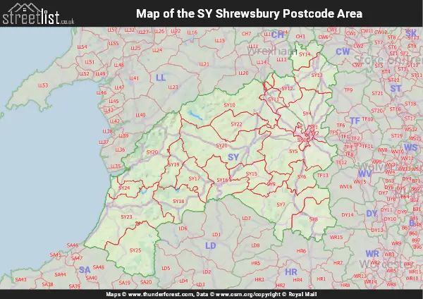
Map of the SY Shrewsbury Postcode Area
Explore the SY Shrewsbury postcode area by using our interactive map.
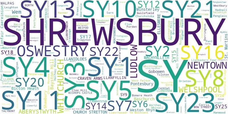
Postcode Districts within the SY Shrewsbury Postcode Area
There are 25 postcode districts within the Shrewsbury postcode area
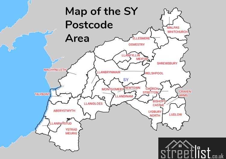
A map showing the boundary of in relation to other areas
There are 18 towns within the Shrewsbury postcode area.
| Unit | Area² |
|---|---|
| Hectares | 6,067,463² |
| Miles | 23,427² |
| Feet | 653,095,649,857² |
| Kilometres | 60,675² |
Postal Delivery Offices serving the SY Shrewsbury Postcode Area
- Aberystwyth Delivery Office
- Church Stretton Delivery Office
- Con Delivery Office Ver Scale Payment Delivery Office
- Craven Arms Delivery Office
- Cressage Scale Payment Delivery Office
- Ellesmere Delivery Office
- Llanfyllin Scale Payment Delivery Office
- Llanidloes Delivery Office
- Ludlow Delivery Office
- Machynlleth Delivery Office
- Minsterley Scale Payment Delivery Office
- Newtown Delivery Office
- Oswestry Delivery Office
- Pontesbury Scale Payment Delivery Office
- Shrewsbury Delivery Office
- Tregaron Scale Payment Delivery Office
- Welshpool Delivery Office
- Wem Delivery Office
- Westbury Scale Payment Delivery Office
- Whitchurch (sy) Delivery Office
Councils with Postcodes in SY
Towns and Villages within the SY Shrewsbury Postcode Area
- Aberangell - village
- Aberhafesp - village
- Aberhosan - village
- Aberllefenni - village
- Abermule - village
- Aberystwyth - town
- Acton Burnell - village
- Adfa - village
- Adforton - village
- Alberbury - village
- All Stretton - village
- Annscroft - village
- Arddlin - village
- Ash Magna - village
- Ashford Carbonell - village
- Astley - village
- Aston - village
- Aston Munslow - village
- Aston on Clun - village
- Atcham - village
- Barton - village
- Baschurch - village
- Batchcott - otherSettlement
- Bayston Hill - village
- Belan - otherSettlement
- Bentlawnt - village
- Berriew - village
- Berrington - village
- Bettisfield - village
- Bettws Cedewain - village
- Bickley Moss - otherSettlement
- Bicton - village
- Bishop's Castle - town
- Bitterley - village
- Blaenpennal - otherSettlement
- Bomere Heath - village
- Bont Dolgadfan - village
- Borth - village
- Bow Street - village
- Brimfield - village
- Brockton - village
- Bromfield - village
- Bronant - village
- Bronington - village
- Bronygarth - village
- Brooklands - village
- Broome - village
- Bucknell - village
- Bulkeley - village
- Burford - village
- Burleydam - village
- Burlton - village
- Buttington - village
- Bwlch-y-cibau - village
- Caerhowel - village
- Caersws - village
- Calverhall - village
- Cantlop - otherSettlement
- Capel Dewi - village
- Cardington - village
- Carno - village
- Castle Caereinion - village
- Caynham - village
- Cefn - village
- Cefn Coch - otherSettlement
- Ceinws - village
- Cemmaes - village
- Chirbury - village
- Church Preen - otherSettlement
- Church Stretton - town
- Churchstoke - village
- Clatter - village
- Cleehill - village
- Clive - village
- Clun - village
- Clunbury - village
- Clungunford - village
- Clunton - village
- Cnwch Coch - village
- Cockshutt - village
- Coedway - village
- Comins Coch - village
- Commins Coch - village
- Condover - village
- Corfton - village
- Corris - village
- Corris Uchaf - village
- Coundarbour - village
- Craven Arms - town
- Cressage - village
- Crewgreen - village
- Criggion - otherSettlement
- Cross Houses - village
- Cross Inn - village
- Cruckton - village
- Culmington - village
- Cwm-Llinau - village
- Cwmystwyth - otherSettlement
- Derwenlas - village
- Diddlebury - village
- Dinas Mawddwy - village
- Dolypandy - village
- Dorrington - village
- Dudleston Heath - village
- Eaton Constantine - village
- Edgebolton - village
- Edgerley - village
- Eglwys Fach - village
- Ellesmere - town
- Elson - village
- Elton - otherSettlement
- Exfords Green - village
- Farden - village
- Fauls - village
- Ffair-Rhos - village
- Foel - village
- Ford - village
- Forden - village
- Forge - village
- Four Crosses - village
- Frodesley - village
- Furnace - village
- Garthmyl - village
- Glantwymyn - village
- Gobowen - village
- Goginan - village
- Grafton - village
- Great Ryton - village
- Grinshill - village
- Guilsfield - village
- Gungrog - otherSettlement
- Hadnall - village
- Halford - village
- Halfway House - village
- Hampton Heath - village
- Hanmer - village
- Hanwood - village
- Hanwood Bank - village
- Harley - village
- Harmer Hill - village
- Harnage - otherSettlement
- Hayton's Bent - village
- Hendomen - village
- Hengoed - village
- Hints - village
- Hook-a-gate - village
- Hope Bagot - otherSettlement
- Hope Bowdler - village
- Hopesay - village
- Horseman's Green - village
- Ightfield - village
- Kerry / Ceri - village
- Kinnerley - village
- Knockin - village
- Knockin Heath - village
- Knowbury - village
- Knowle - village
- Lee Brockhurst - village
- Leebotwood - village
- Leighton - village
- Leintwardine - village
- Little Hereford - village
- Little Ness - village
- Little Ryton - village
- Little Stretton - village
- Llanafan - village
- Llanbadarn Fawr - village
- Llanbrynmair - village
- Llanddeiniol - village
- Llanddewi Brefi - village
- Llandrinio - village
- Llandyssil - village
- Llanerfyl - village
- Llanfair Caereinion - town
- Llanfarian - village
- Llanfechain - village
- Llanfihangel-geneu'r-glyn / Llandre - village
- Llanfihangel-y-Creuddyn - village
- Llanfyllin - town
- Llangadfan - village
- Llangedwyn - village
- Llangeitho - village
- Llangorwen - village
- Llangurig - village
- Llangwyryfon - village
- Llangynog - village
- Llanidloes - town
- Llanilar - village
- Llanllwchaiarn - village
- Llannon / Llanon - village
- Llanrhaeadr-ym-Mochnant - village
- Llanrhystud - village
- Llansantffraed / Llansantffraid - village
- Llansantffraidd-ym-Mechain - village
- Llansilin - village
- Llanwddyn - village
- Llanwnog - village
- Llanymynech - village
- Llawr-y-glyn - village
- Lledrod - village
- Llwyn-y-groes - village
- Llynclys - village
- Longden - village
- Longden Common - village
- Longnor - village
- Loppington - village
- Ludford - village
- Ludlow - town
- Lydbury North - village
- Lydham - village
- Lyneal - village
- Lythbank - village
- Machynlleth - town
- Maes-bangor - village
- Maesbrook - village
- Maesbury - village
- Maesbury Marsh - village
- Malpas - village
- Manafon - village
- Marbury - village
- Marchamley - village
- Marton - village
- Meifod - village
- Merrington - otherSettlement
- Middleton - village
- Middletown - village
- Minllyn - village
- Minsterley - village
- Montford Bridge - village
- Morda - village
- Moretonwood - otherSettlement
- Morton - village
- Munslow - village
- Myddle - village
- Nantmawr - village
- Nesscliffe - village
- Newcastle - village
- Newtown - town
- Newtown - village
- No Man's Heath - village
- Northwood - village
- Onibury - village
- Orleton - village
- Oswestry - town
- Pant - village
- Park Hall - village
- Pen-y-garn - village
- Penegoes - village
- Pennal - village
- Pennant - village
- Pennerley - otherSettlement
- Penrhyn-coch - village
- Pentre - village
- Pentre - village
- Pentre-llyn - village
- Penybontfawr - village
- Perthy - village
- Petton - village
- Plealey - village
- Pont Lanio - village
- Pont-rhyd-y-groes - village
- Pontarfynach / Devil's Bridge - village
- Ponterwyd - village
- Pontesbury - village
- Pontesford - village
- Pontrhydfendigaid - village
- Pontrobert - village
- Pool Quay - village
- Porth-y-waen - village
- Prees - village
- Prees Green - village
- Prees Heath - village
- Prees Higher Heath - village
- Priest Weston - village
- Pulverbatch - village
- Queen's Head - village
- Rednal - otherSettlement
- Rhewl - village
- Rhoswiel - village
- Rhydypennau - village
- Richards Castle - village
- Rockgreen - village
- Rodington - village
- Rodington Heath - village
- Rowton - village
- Ruyton-XI-Towns - village
- Sarn - village
- Seifton - village
- Selattyn - village
- Shawbury - village
- Sheet - village
- Shocklach - village
- Shrawardine - village
- Shrewsbury - town
- Snailbeach - village
- Somerwood - village
- St Martins - village
- Stanton upon Hine Heath - village
- Stapleton - village
- Steel Heath - otherSettlement
- Stepaside - village
- Stiperstones - village
- Stoke St Milborough - village
- Tal-y-bont - village
- Tallarn Green - village
- Tetchill - village
- Threapwood - village
- Tilstock - village
- Tilston - village
- Tre Taliesin - village
- Tre'r llai / Leighton - village
- Tre'r-ddol - village
- Trefaldwyn / Montgomery - town
- Trefeglwys - village
- Treflach - village
- Trefonen - village
- Tregaron - town
- Tregynon - village
- Trewern - village
- Uffington - village
- Upper Battlefield - village
- Upper Cound - village
- Upton Magna - village
- Walford Heath - village
- Wall under Heywood - village
- Wattlesborough Heath - village
- Weirbrook - otherSettlement
- Welshampton - village
- Welshpool / Y Trallwng - town
- Wem - town
- Wentnor - village
- Wern - village
- West Felton - village
- Westbury - village
- Westhope - otherSettlement
- Weston - village
- Weston Lullingfields - village
- Weston Rhyn - village
- Westoncommon - village
- Whitchurch - town
- Whitehaven - village
- Whittington - village
- Whitton - village
- Whixall - otherSettlement
- Wilcott - village
- Wistanstow - village
- Withington - village
- Worthen - village
- Wroxeter - village
- Wykey - otherSettlement
- Wyson - village
- Ynyslas - village
- Yockleton - village
- Ysbyty Ystwyth - village