This section of the site is all about the LD Postcode area, also known as the Llandrindod Wells Postal Area. Explore links to the next level to learn more about specific postcode districts such as LD1.
The LD postcode area represents a group of postal districts in the Llandrindod Wells area of the United Kingdom. The area code LD stands for the letters l and d in LlandrindoD Wells. LD has a population of 49,792 and covers an area of 2,437,799 hectares. Fun fact: 0.08% of the population of Great Britain lives in this area.
The postcode area falls within the following counties: Powys (97.99%), Herefordshire (1.09%), Shropshire (0.92%).
Post Towns and Postcode Districts for the LD Postcode
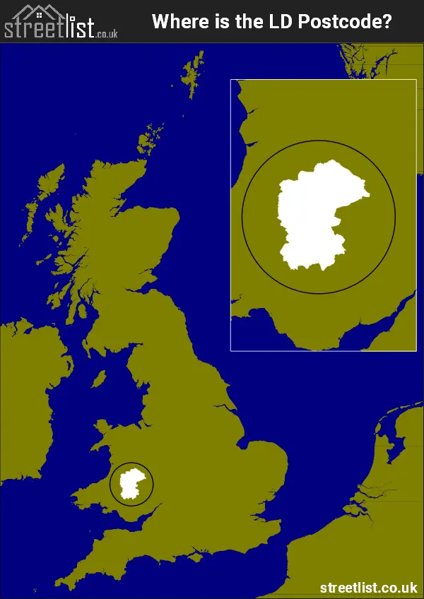
Where is the LD Postcode Area?
The LD Llandrindod Wells Postcode is in Wales. The postal area borders the following neighbouring postal areas: SY - Shrewsbury, CF - Cardiff, SA - Swansea, NP - Newport and HR - Hereford, and is located inland.
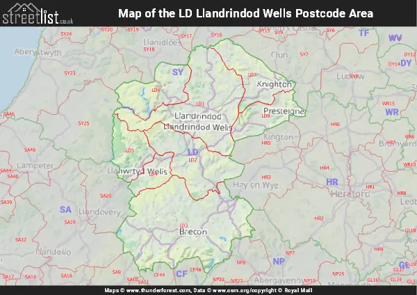
Map of the LD Llandrindod Wells Postcode Area
Explore the LD Llandrindod Wells postcode area by using our interactive map.
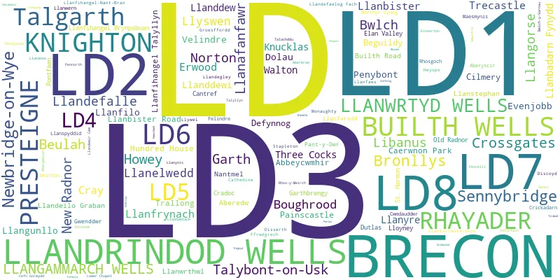
Postcode Districts within the LD Llandrindod Wells Postcode Area
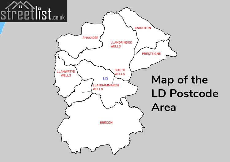
There are 8 postcode districts within the Llandrindod Wells postcode area
A map showing the boundary of in relation to other areas
There are 8 towns within the Llandrindod Wells postcode area.
| Unit | Area² |
|---|---|
| Hectares | 2,437,799² |
| Miles | 9,412² |
| Feet | 262,402,246,561² |
| Kilometres | 24,378² |
Postal Delivery Offices serving the LD Llandrindod Wells Postcode Area
- Brecon Delivery Office
- Builth Wells Delivery Office
- Knighton Delivery Office
- Llandrindod Wells Delivery Office
- Rhayader Scale Payment Delivery Office
Councils with Postcodes in LD
Towns and Villages within the LD Llandrindod Wells Postcode Area
- Aberedw - village
- Aberhonddu / Brecon - town
- Beulah - village
- Boughrood - village
- Bronllys - village
- Builth Road - village
- Bwlch - village
- Cilmery - village
- Cradoc - village
- Crossway - village
- Defynnog - village
- Erwood - village
- Evenjobb - village
- Felindre - village
- Felinfach - village
- Fron - village
- Garth - village
- Hawy / Howey - village
- Knucklas - village
- Llanandras / Presteigne - town
- Llanbister - village
- Llanddew - village
- Llanddewi Ystradenni - village
- Llandrindod / Llandrindod Wells - town
- Llanelwedd - village
- Llanfair-ym-Muallt / Builth Wells - town
- Llanfihangel Tal-y-llyn - village
- Llanfrynach - village
- Llangammarch Wells - village
- Llangors - village
- Llangunllo - village
- Llanllyr / Llanyre - village
- Llansantffraed-Cwmdeuddwr - village
- Llanspyddid - village
- Llanwrtyd Wells - town
- Llyswen - village
- Maesyfed / New Radnor - village
- Newbridge-on-Wye - village
- Norton - village
- Painscastle - village
- Pant-y-dwr - village
- Pennorth - village
- Penybont - village
- Rhayader / Rhaeadr Gwy - town
- Rhos-goch - village
- Sennybridge / Pontsenni - village
- St Harmon - village
- Tai'r Bull - village
- Talgarth - town
- Talybont-on-Usk - village
- Three Cocks - village
- Trecastle / Trecastell - village
- Tref-y-Clawdd / Knighton - town
- Y Clas-ar-Wy / Glasbury - village