The LD8 postcode district is a postal district located in the LD Llandrindod Wells postcode area with a population of 4,491 residents according to the 2021 England and Wales Census.
The area of the LD8 postcode district is 63.84 square miles which is 165.35 square kilometres or 40,858.07 acres.
Currently, the LD8 district has about 193 postcode units spread across 1 geographic postcode sectors.
Given that each sector allows for 400 unique postcode combinations, the district has a capacity of 400 postcodes. With 193 postcodes already in use, this leaves 207 units available.
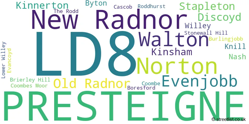
The largest settlement in the LD8 postal code is PRESTEIGNE followed by NEW RADNOR, and NORTON.
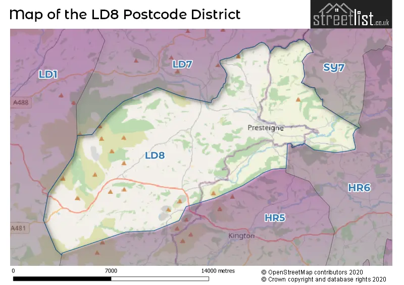
The LD8 Postcode shares a border with HR5 (KINGTON, Lyonshall, Titley), HR6 (LEOMINSTER, Kingsland, Pembridge), SY7 (CRAVEN ARMS, Leintwardine, Clun) and LD7 (KNIGHTON, KNUCKLAS, LLANGUNLLO).
In the LD8 postcode district, the primary settlement is Presteigne, which is located in both Herefordshire and Powys. Other significant settlements in the district include Boresford, Brierley Hill, Byton, Cascob, Coombe, Coombes Moor, Discoyd, Evancoyd, Evenjobb, Kinnerton, Kinsham, Knill, Lower Willey, Nash, New Radnor, Norton, Old Radnor, Roddhurst, Stapleton, Stonewall Hill, The Rodd, Walton, and Willey. The most significant post town in the LD8 district is Presteigne.
For the district LD8, we have data on 1 postcode sectors. Here's a breakdown: The sector LD8 2, covers Presteigne and New Radnor in Powys.
LD8 Postcode Sectors

Map of the LD8 Postcode District
Explore the LD8 postcode district by using our free interactive map.
When it comes to local government, postal geography often disregards political borders. However, for a breakdown in the LD8 District: the district mostly encompasses the Powys - Powys (165 postcodes), and finally, the County of Herefordshire area (26 postcodes).
Recent House Sales in LD8
| Date | Price | Address |
|---|---|---|
| 19/10/2023 | £180,000 | Harpers Lane, Presteigne, LD8 2AN |
| 22/09/2023 | £230,000 | Caenbrook Meadow, Presteigne, LD8 2NE |
| 08/09/2023 | £240,000 | Warden Close, Presteigne, LD8 2DH |
| 01/09/2023 | £167,500 | Townend, Presteigne, LD8 2DW |
| 31/08/2023 | £325,000 | Discoyd, Presteigne, LD8 2NW |
| 24/08/2023 | £297,500 | Broad Street, New Radnor, Presteigne, LD8 2SP |
| 18/08/2023 | £215,000 | Hereford Street, Presteigne, LD8 2AR |
| 04/08/2023 | £310,000 | Warden Close, Presteigne, LD8 2DH |
| 03/08/2023 | £481,000 | Offas Green, Norton, Presteigne, LD8 2NX |
| 02/08/2023 | £1,500,000 | Willey, Presteigne, LD8 2LY |
Weather Forecast for LD8
Press Button to Show Forecast for Bache Hill
| Time Period | Icon | Description | Temperature | Rain Probability | Wind |
|---|---|---|---|---|---|
| 03:00 to 06:00 | Light rain | 1.0°C (feels like -5.0°C) | 58.00% | ENE 16 mph | |
| 06:00 to 09:00 | Sleet | 1.0°C (feels like -5.0°C) | 50.00% | ENE 18 mph | |
| 09:00 to 12:00 | Sleet | 2.0°C (feels like -4.0°C) | 53.00% | ENE 18 mph | |
| 12:00 to 15:00 | Overcast | 3.0°C (feels like -2.0°C) | 24.00% | ENE 18 mph | |
| 15:00 to 18:00 | Light rain | 3.0°C (feels like -1.0°C) | 51.00% | ENE 16 mph | |
| 18:00 to 21:00 | Cloudy | 3.0°C (feels like -1.0°C) | 18.00% | NE 16 mph | |
| 21:00 to 00:00 | Overcast | 3.0°C (feels like -3.0°C) | 19.00% | NE 18 mph |
Press Button to Show Forecast for Bache Hill
| Time Period | Icon | Description | Temperature | Rain Probability | Wind |
|---|---|---|---|---|---|
| 00:00 to 03:00 | Overcast | 2.0°C (feels like -4.0°C) | 13.00% | NNE 18 mph | |
| 03:00 to 06:00 | Overcast | 1.0°C (feels like -5.0°C) | 17.00% | NNE 16 mph | |
| 06:00 to 09:00 | Overcast | 1.0°C (feels like -4.0°C) | 16.00% | N 16 mph | |
| 09:00 to 12:00 | Cloudy | 3.0°C (feels like -1.0°C) | 13.00% | NNW 13 mph | |
| 12:00 to 15:00 | Overcast | 6.0°C (feels like 2.0°C) | 15.00% | NW 11 mph | |
| 15:00 to 18:00 | Cloudy | 7.0°C (feels like 3.0°C) | 7.00% | WNW 13 mph | |
| 18:00 to 21:00 | Sunny day | 6.0°C (feels like 2.0°C) | 1.00% | W 11 mph | |
| 21:00 to 00:00 | Clear night | 1.0°C (feels like -3.0°C) | 1.00% | WSW 11 mph |
Press Button to Show Forecast for Bache Hill
| Time Period | Icon | Description | Temperature | Rain Probability | Wind |
|---|---|---|---|---|---|
| 00:00 to 03:00 | Partly cloudy (night) | 1.0°C (feels like -4.0°C) | 2.00% | SSW 13 mph | |
| 03:00 to 06:00 | Cloudy | 1.0°C (feels like -4.0°C) | 7.00% | SSW 13 mph | |
| 06:00 to 09:00 | Cloudy | 3.0°C (feels like -2.0°C) | 8.00% | S 16 mph | |
| 09:00 to 12:00 | Cloudy | 6.0°C (feels like 1.0°C) | 10.00% | S 18 mph | |
| 12:00 to 15:00 | Overcast | 7.0°C (feels like 3.0°C) | 16.00% | S 20 mph | |
| 15:00 to 18:00 | Cloudy | 8.0°C (feels like 4.0°C) | 14.00% | S 20 mph | |
| 18:00 to 21:00 | Cloudy | 7.0°C (feels like 3.0°C) | 16.00% | S 18 mph | |
| 21:00 to 00:00 | Cloudy | 5.0°C (feels like 0.0°C) | 14.00% | SSE 18 mph |
Press Button to Show Forecast for Bache Hill
| Time Period | Icon | Description | Temperature | Rain Probability | Wind |
|---|---|---|---|---|---|
| 00:00 to 03:00 | Cloudy | 4.0°C (feels like -1.0°C) | 17.00% | SE 18 mph | |
| 03:00 to 06:00 | Cloudy | 4.0°C (feels like -1.0°C) | 16.00% | SE 18 mph | |
| 06:00 to 09:00 | Cloudy | 4.0°C (feels like -1.0°C) | 16.00% | SE 18 mph | |
| 09:00 to 12:00 | Cloudy | 7.0°C (feels like 3.0°C) | 15.00% | SE 18 mph | |
| 12:00 to 15:00 | Cloudy | 10.0°C (feels like 6.0°C) | 16.00% | SE 20 mph | |
| 15:00 to 18:00 | Cloudy | 10.0°C (feels like 7.0°C) | 19.00% | SE 18 mph | |
| 18:00 to 21:00 | Partly cloudy (day) | 9.0°C (feels like 6.0°C) | 10.00% | SE 13 mph | |
| 21:00 to 00:00 | Cloudy | 6.0°C (feels like 2.0°C) | 10.00% | ESE 11 mph |
Where is the LD8 Postcode District?
The LD8 postcode district is located in Presteigne, which is a District Town. It is situated in close proximity to several nearby towns. The South direction leads to the town of Kington, which is approximately 5.01 miles away. The North direction takes you to Knighton, which is around 6.13 miles away. Moving North East will bring you to Bucknell, which is approximately 9.26 miles away. Heading towards the West will lead you to Llandrindod Wells, which is around 11.71 miles away. Going towards the East will take you to Leominster, which is approximately 14.92 miles away. Lastly, the South West direction will lead you to Builth Wells, which is around 15.53 miles away. Additionally, the LD8 postcode district is approximately 136.69 miles away from the center of London.
The district is within the post town of PRESTEIGNE.
The sector has postcodes within the nations of Wales, England.
The LD8 Postcode District is covers the following regions.
- Powys - East Wales - Wales
- Herefordshire, County of - Herefordshire, Worcestershire and Warwickshire - West Midlands (England)
Postcode Sectors within the LD8 District
| Postcode Sector | Delivery Office |
|---|---|
| LD8 2 | Knighton Delivery Office |
| L | D | 8 | - | X | X | X |
| L | D | 8 | Space | Numeric | Letter | Letter |
Tourist Attractions within the Postcode Area
We found 2 visitor attractions within the LD8 postcode area
| Croft Castle |
|---|
| Historic Properties |
| Historic House / House and Garden / Palace |
| View Croft Castle on Google Maps |
| The Judge's Lodging |
| View The Judge's Lodging on Google Maps |
Current Monthly Rental Prices
| # Bedrooms | Min Price | Max Price | Avg Price |
|---|
Current House Prices
| # Bedrooms | Min Price | Max Price | Avg Price |
|---|---|---|---|
| 2 | £130,000 | £585,000 | £235,833 |
| 3 | £190,000 | £895,000 | £390,445 |
| 4 | £400,000 | £900,000 | £652,500 |
| 5 | £350,000 | £850,000 | £667,500 |
| 6 | £1,385,000 | £1,385,000 | £1,385,000 |
| 13 | £600,000 | £600,000 | £600,000 |
| 14 | £2,000,000 | £2,000,000 | £2,000,000 |
Estate Agents who Operate in the LD8 District
| Logo | Name | Brand Name | Address | Contact Number | Total Properties |
|---|---|---|---|---|---|
 | Kington | Chancellors | 5 High Street, Kington, HR5 3AX | 01544 300865 | 9 |
 | Hay-On-Wye | McCartneys LLP | 11 High Town, Hay-On-Wye, HR3 5AE | 01497 701050 | 3 |
 | Hay-On-Wye | Fine & Country | 11 High Town, Hay-On-Wye, HR3 5AE | 01497 701062 | 3 |
 | Knighton | Cobb Amos | 22 Broad Street, Knighton, LD7 1BL | 01547 316348 | 3 |
 | Leominster | Jackson Property | 3 Broad Street, Leominster, HR6 8BT | 01568 605229 | 2 |
| Type of Property | 2018 Average | 2018 Sales | 2017 Average | 2017 Sales | 2016 Average | 2016 Sales | 2015 Average | 2015 Sales |
|---|---|---|---|---|---|---|---|---|
| Detached | £276,795 | 42 | £292,831 | 36 | £246,570 | 55 | £257,306 | 39 |
| Semi-Detached | £195,357 | 7 | £220,833 | 21 | £161,959 | 11 | £203,545 | 11 |
| Terraced | £169,447 | 19 | £159,107 | 14 | £147,600 | 15 | £168,357 | 7 |
| Flats | £0 | 0 | £0 | 0 | £58,000 | 1 | £0 | 0 |