This section of the site is all about the LL Postcode area, also known as the Llandudno Postal Area. Explore links to the next level to learn more about specific postcode districts such as LL11.
The LL postcode area represents a group of postal districts in the Llandudno area of the United Kingdom. The area code LL stands for the letters l and l in LLandudno. LL has a population of 537,467 and covers an area of 5,452,295 hectares. Fun fact: 0.83% of the population of Great Britain lives in this area.
The postcode area falls within the following counties: Clwyd (59.58%), Gwynedd (40.30%), Shropshire (0.12%).
Post Towns and Postcode Districts for the LL Postcode
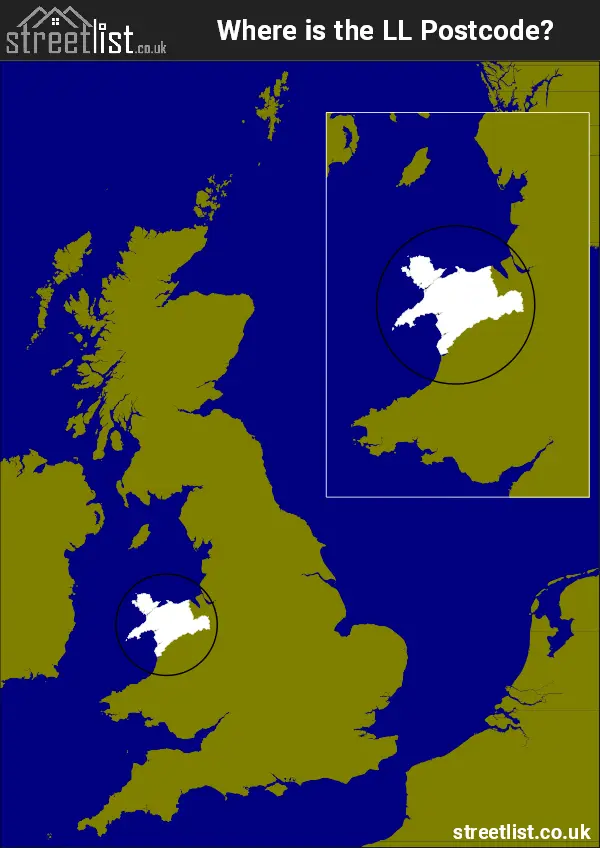
Where is the LL Postcode Area?
The LL Llandudno Postcode is in Wales. The postal area borders the following neighbouring postal areas: SY - Shrewsbury and CH - Chester, It also borders Menai Strait, The Irish Sea, Cardigan Bay and Caernarfon Bay.
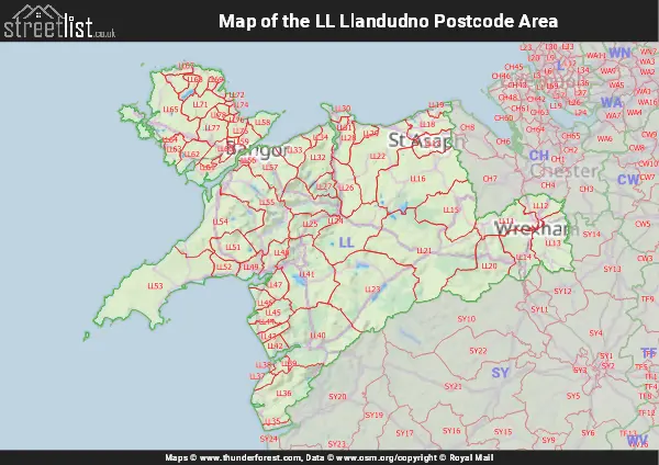
Map of the LL Llandudno Postcode Area
Explore the LL Llandudno postcode area by using our interactive map.
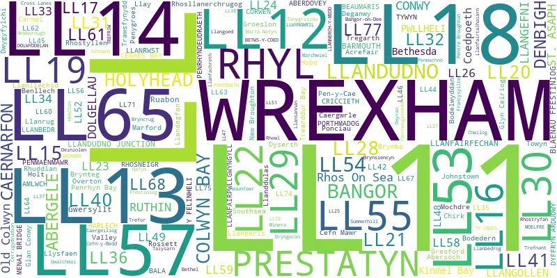
Postcode Districts within the LL Llandudno Postcode Area
There are 67 postcode districts within the Llandudno postcode area
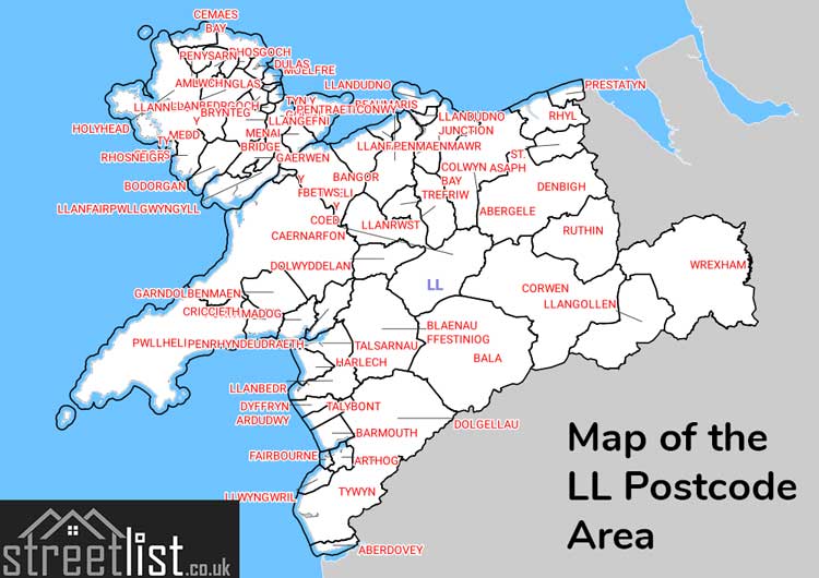
A map showing the boundary of in relation to other areas
There are 34 towns within the Llandudno postcode area.
| Unit | Area² |
|---|---|
| Hectares | 5,452,295² |
| Miles | 21,051² |
| Feet | 586,879,581,505² |
| Kilometres | 54,523² |
Postal Delivery Offices serving the LL Llandudno Postcode Area
- Amlwch Delivery Office
- Bala Delivery Office
- Bangor (ll) Delivery Office
- Barmouth Delivery Office
- Betws Y Coed Delivery Office
- Blaenau Ffestiniog Delivery Office
- Caernarfon Delivery Office
- Colwyn Bay Delivery Office
- Corwen Delivery Office
- Denbigh (ll) Delivery Office
- Dolgellau Delivery Office
- Holyhead Delivery Office
- Llandudno Delivery Office
- Llangefni Delivery Office
- Llangollen Delivery Office
- Llanrwst Delivery Office
- Porthmadog Delivery Office
- Prestatyn Delivery Office
- Pwllheli Delivery Office
- Rhyl Delivery Office
- Ruthin Delivery Office
- Tywyn Delivery Office
- Wrexham Delivery Office
Councils with Postcodes in LL
Towns and Villages within the LL Llandudno Postcode Area
- Aberdaron - village
- Aberdesach - village
- Aberdovey - village
- Abererch - village
- Aberffraw - village
- Abergele - town
- Abergwyngregyn - village
- Abergynolwyn - village
- Abermaw / Barmouth - town
- Abermorddu - village
- Abersoch - village
- Aberwheeler - village
- Acrefair - village
- Afon-wen - village
- Amlwch - town
- Arthog - village
- Bangor-on-Dee - village
- Beaumaris - town
- Beddgelert - village
- Belgrano - village
- Benllech - village
- Bersham - village
- Berwyn - otherSettlement
- Bethel - village
- Bethel - village
- Bethesda - town
- Bethesda Bach - village
- Bettws Gwerfil Goch - village
- Betws Garmon - otherSettlement
- Betws-y-Coed - town
- Betws-yn-Rhos - village
- Blaenau Ffestiniog - town
- Bodedern - village
- Bodfari - village
- Bodffordd - village
- Bontddu - village
- Bontnewydd - village
- Borth-y-Gest - village
- Botwnnog - village
- Bradley - village
- Brithdir - village
- Brymbo - village
- Bryn Du - village
- Bryn Pydew - village
- Bryncroes - village
- Bryncrug - village
- Bryneglwys - village
- Bryngwran - village
- Brynrefail - village
- Brynrefail - village
- Brynsiencyn - village
- Brynteg - village
- Brynteg - village
- Burton - village
- Bwlch - village
- Bwlchgwyn - village
- Bwlchtocyn - village
- Caeathro - village
- Caergeiliog - village
- Caergwrle - village
- Caerhun - village
- Caernarfon - town
- Capel Curig - village
- Capel Garmon - village
- Capelulo - village
- Carmel - village
- Carmel - village
- Carreglefn - village
- Carrog - village
- Cefn-bychan - village
- Cefn-mawr - village
- Cefn-y-bedd - village
- Cemaes - village
- Cerrigydrudion - village
- Chirk Bank - village
- Chwilog - village
- Clawdd Poncen - village
- Clawdd-newydd - village
- Clocaenog - village
- Clwt-y-bont - village
- Clynnog-fawr - village
- Coed Ystumgwern - village
- Coed-y-parc - village
- Coedpoeth - village
- Colwyn Bay - town
- Conwy - town
- Corwen - village
- Cricieth / Criccieth - town
- Cross Lanes - village
- Cwm - village
- Cwm Penmachno - village
- Cwm-y-glo - village
- Cyffylliog - village
- Cymau - village
- Cynwyd - village
- Darland - village
- Ddol - village
- Deiniolen - village
- Denbigh / Dinbych - town
- Derwen - village
- Dinas - village
- Dinas - village
- Dinorwig - village
- Dolgarrog - village
- Dolgellau - town
- Dolwyddelan - village
- Dwygyfylchi - village
- Dwyran - village
- Dyffryn Ardudwy - village
- Dyserth - village
- Edern - village
- Efailnewydd - village
- Eglwysbach - village
- Erbistock - village
- Fairbourne - village
- Ffrith - village
- Four Mile Bridge - village
- Friog - village
- Froncysyllte - village
- Fryars Bay - village
- Gaerwen - village
- Ganllwyd - village
- Garndolbenmaen - village
- Garreg - village
- Garth - village
- Garth Trevor - village
- Gegin - village
- Gellifor - village
- Gellilydan - village
- Glan-yr-afon - village
- Glan-yr-afon - village
- Glanwydden - village
- Glasinfryn - village
- Glyn Ceiriog - village
- Glyndyfrdwy - village
- Graig-fechan - village
- Green - village
- Greenfields - village
- Gresford - village
- Groes - village
- Groesffordd - village
- Groeslon - village
- Groeslon - village
- Gronant - village
- Gwaenysgor - village
- Gwalchmai - village
- Gwersyllt - village
- Gwyddelwern - village
- Gwynfryn - village
- Hafan y Mor - otherSettlement
- Harlech - town
- Hen Bentref Llandegfan - village
- Henllan - village
- Henryd - village
- Hermon - village
- Holt - village
- Holyhead - town
- Hope - village
- Kinmel Bay / Bae Cinmel - Settlement
- Lavister - village
- Lightwood Green - otherSettlement
- Llan Ffestiniog - village
- Llanaber - village
- Llanaelhaearn - village
- Llanallgo - village
- Llanarmon Dyffryn Ceiriog - village
- Llanbedr - village
- Llanbedr-Dyffryn-Clwyd - village
- Llanbedr-y-cennin - village
- Llanbedrgoch - village
- Llanbedrog - village
- Llanberis - village
- Llanddaniel Fab - village
- Llandderfel - village
- Llanddeusant - village
- Llanddoged - village
- Llanddona - village
- Llanddulas - village
- Llanddwywe - village
- Llandecwyn - village
- Llandegfan - village
- Llandegla - village
- Llandrillo - village
- Llandudno - town
- Llandwrog - village
- Llandygai - village
- Llandyrnog - village
- Llanegryn - village
- Llaneilian - village
- Llanelian-yn-Rhos - village
- Llanelidan - village
- Llanelltyd - village
- Llanelwy / St Asaph - city
- Llanenddwyn - village
- Llanengan - village
- Llanerchymedd - village
- Llanfachraeth - village
- Llanfachreth - village
- Llanfaelog - village
- Llanfaes - village
- Llanfaethlu - village
- Llanfaglan - village
- Llanfair - village
- Llanfair Dyffryn Clwyd - village
- Llanfair Pwllgwyngyll - village
- Llanfair Talhaiarn - village
- Llanfair-yng-Nghornwy - village
- Llanfairfechan - town
- Llanfechell - village
- Llanfigael - village
- Llanfihangel yn Nhowyn - village
- Llanfor - village
- Llanfwrog - village
- Llanfwrog - village
- Llanfynydd - village
- Llangaffo - village
- Llangefni - town
- Llangernyw - village
- Llangoed - village
- Llangollen - town
- Llangristiolus - village
- Llangwm - village
- Llangwnnadl - village
- Llangybi - village
- Llanllechid - village
- Llanllyfni - village
- Llannefydd - village
- Llannor - village
- Llanrhaeadr - village
- Llanrhuddlad - village
- Llanrug - village
- Llanrwst - town
- Llansadwrn - village
- Llansan Sior / St George - village
- Llansanffraid Glan Conwy - village
- Llansannan - village
- Llanuwchllyn - village
- Llanynghenedl - otherSettlement
- Llanystumdwy - village
- Llay - village
- Llechwedd - otherSettlement
- Llidiart-y-Parc - village
- Llithfaen - village
- Llwyn-hudol - village
- Llwyngwril - village
- Llwynmawr - village
- Llynfaes - village
- Llysfaen - village
- Machroes - village
- Maentwrog - village
- Maerdy - village
- Malltraeth - village
- Marchwiel - village
- Marian-glas - village
- Meliden - village
- Melin-y-coed - village
- Minera - village
- Minffordd - village
- Moelfre - village
- Mona - otherSettlement
- Morfa Bychan - village
- Morfa Nefyn - village
- Mynydd Llandegai - village
- Mynydd Marian - village
- Mynydd Mechell - village
- Mynytho - village
- Nant Peris - village
- Nant-y-Patrick - village
- Nantglyn - village
- Nantlle - village
- Nebo - village
- Nefyn - town
- New Brighton - village
- New Broughton - village
- Newbridge - village
- Newmarket - village
- Niwbwrch / Newborough - village
- Owrtyn / Overton - village
- Parc - village
- Pen-y-garnedd - otherSettlement
- Pen-y-groeslon - otherSettlement
- Pen-y-stryt - village
- Pencarnisiog - village
- Penisa'r Waun - village
- Penley - village
- Penmachno - village
- Penmaenmawr - town
- Penmon - village
- Penmorfa - village
- Penrhos - village
- Penrhyn Bay - village
- Penrhyn-side - village
- Penrhyndeudraeth - village
- Pensarn - village
- Pentir - village
- Pentraeth - village
- Pentre Berw - village
- Pentre Maelor - village
- Pentre-Llanrhaeadr - village
- Pentrefelin - village
- Pentrefelin - village
- Pentrefelin - village
- Pentrefoelas - village
- Penycae - village
- Penygroes - village
- Penysarn - village
- Pistyll - village
- Plas Madoc - village
- Pont-y-pant - otherSettlement
- Pontfadog - village
- Pontllyfni - village
- Porthaethwy / Menai Bridge - town
- Porthllechog / Bull Bay - village
- Porthmadog - town
- Portmeirion - otherSettlement
- Prenteg - village
- Prestatyn - town
- Prion - otherSettlement
- Pwll-gos - village
- Pwllheli - town
- R Efail Estate - village
- Rachub - village
- Rackery - otherSettlement
- Red Wharf Bay - village
- Rh?s-y-llan - otherSettlement
- Rhewl - village
- Rhiw - village
- Rhiwlas - village
- Rhos Isaf - village
- Rhos-y-gwaliau - otherSettlement
- Rhoscefnhir - village
- Rhoscolyn / Llangwenfaen - village
- Rhosgadfan - town
- Rhosgoch - village
- Rhoshirwaun - village
- Rhoslan - village
- Rhosllannerchrugog - village
- Rhosmeirch - village
- Rhosneigr - village
- Rhostrehwfa - village
- Rhostryfan - village
- Rhostyllen - village
- Rhosybol - village
- Rhosymedre - village
- Rhuallt - village
- Rhuddlan - town
- Rhuthun / Ruthin - town
- Rhyd-Ddu - village
- Rhyd-wyn - village
- Rhyd-y-clafdy - village
- Rhyd-y-foel - village
- Rhydlios - otherSettlement
- Rhyl - town
- Rossett - village
- Rowen - village
- Ruabon / Rhiwabon - village
- Sarn Bach - village
- Sarn Mellteyrn - village
- Seion - village
- Sling - village
- Southsea - village
- Star - village
- Sydallt - village
- Tal-y-bont - village
- Tal-y-bont - village
- Tal-y-bont - village
- Tal-y-cafn - village
- Talsarnau - village
- Talwrn - village
- Talwrn - village
- Talysarn - village
- Tan-y-coed - village
- Tanyfron - village
- Tanygrisiau - village
- Terfyn - village
- Towyn - village
- Trawsfynydd - village
- Trearddur - village
- Trefnant - village
- Trefor - village
- Trefriw - village
- Tregarth - village
- Tregele - village
- Tremadog - village
- Tremeirchion - village
- Trevalyn - village
- Trevor - village
- Tudweiliog - village
- Ty'n-y-groes - village
- Tynygongl - village
- Tywyn - town
- Waun - village
- Waunfawr - village
- Worthenbury - village
- Wrexham - town
- Y Bala - town
- Y Fali / Valley - village
- Y Felinheli - village
- Y Ffor - village
- Y Fron - village
- Y Waun / Chirk - town
- Ynys - village
- Yr Arwydd - village
- Ysbyty Ifan - village