The LL11 postcode district is a postal district located in the LL Llandudno postcode area with a population of 38,322 residents according to the 2021 England and Wales Census.
The area of the LL11 postcode district is 37.89 square miles which is 98.13 square kilometres or 24,249.58 acres.
Currently, the LL11 district has about 1293 postcode units spread across 6 geographic postcode sectors.
Given that each sector allows for 400 unique postcode combinations, the district has a capacity of 2,400 postcodes. With 1293 postcodes already in use, this leaves 1107 units available.
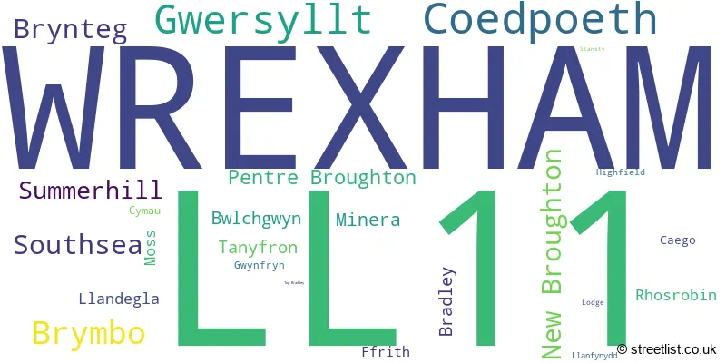
The largest settlement in the LL11 postal code is WREXHAM followed by GWERSYLLT, and COEDPOETH.
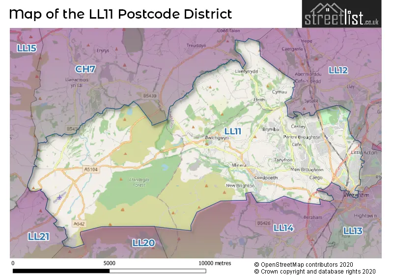
The LL11 Postcode shares a border with LL12 (WREXHAM, LLAY, GRESFORD), LL13 (WREXHAM, WREXHAM INDUSTRIAL ESTATE, PENLEY), LL15 (RUTHIN, LLANBEDR DYFFRYN CLWYD, LLANFAIR DYFFRYN CLWYD), CH7 (BUCKLEY, MOLD, MYNYDD ISA), LL14 (RHOSLLANERCHRUGOG, RUABON, CHIRK), LL20 (LLANGOLLEN, GLYN CEIRIOG, TREVOR) and LL21 (CORWEN, LLANDRILLO, CYNWYD).
In the LL11 postcode district, the primary settlement is Wrexham, which is located in the county of Clwyd. Other significant settlements in the district include Coedpoeth and Minera. Wrexham is the most significant post town within the district.
For the district LL11, we have data on 7 postcode sectors. Here's a breakdown: The sector LL11 0 is non-geographic. It's often designated for PO Boxes, large organisations, or special services. The sector LL11 1, covers Wrexham in Clwyd. The sector LL11 2, covers Wrexham in Clwyd. The sector LL11 3, covers Coedpoeth and Minera and Llandegla in Clwyd. The sector LL11 4, covers Gwersyllt and Summerhill and Bradley and Rhosrobin in Clwyd. The sector LL11 5, covers Brymbo and Bwlchgwyn and Tanyfron and Southsea in Clwyd. The sector LL11 6, covers Brynteg and New Broughton and Pentre Broughton and Southsea and Moss in Clwyd.

Map of the LL11 Postcode District
Explore the LL11 postcode district by using our free interactive map.
When it comes to local government, postal geography often disregards political borders. However, for a breakdown in the LL11 District: the district mostly encompasses the Wrecsam - Wrexham (1220 postcodes), followed by the Sir y Fflint - Flintshire area (40 postcodes), and finally, the Sir Ddinbych - Denbighshire area (27 postcodes).
Recent House Sales in LL11
| Date | Price | Address |
|---|---|---|
| 13/10/2023 | £88,000 | Rhosddu Road, Wrexham, LL11 2NG |
| 11/10/2023 | £225,000 | Hampshire Drive, Wrexham, LL11 2UT |
| 10/10/2023 | £136,000 | High Street, Southsea, Wrexham, LL11 5PB |
| 29/09/2023 | £260,000 | Whitehead Drive, New Broughton, Wrexham, LL11 6BZ |
| 22/09/2023 | £250,000 | Meadway Close, Gwersyllt, Wrexham, LL11 4RX |
| 11/09/2023 | £312,500 | Weston Drive, Wrexham, LL11 2DE |
| 08/09/2023 | £160,000 | Plas Alyn, Summerhill, Wrexham, LL11 4QA |
| 08/09/2023 | £275,000 | Chester Road, Wrexham, LL11 2SW |
| 04/09/2023 | £105,000 | Hope Street, Wrexham, LL11 1BE |
| 01/09/2023 | £300,000 | Mold Road, Gwersyllt, Wrexham, LL11 4AQ |
Weather Forecast for LL11
Press Button to Show Forecast for Treuddyn
| Time Period | Icon | Description | Temperature | Rain Probability | Wind |
|---|---|---|---|---|---|
| 06:00 to 09:00 | Partly cloudy (day) | 3.0°C (feels like 1.0°C) | 3.00% | ESE 4 mph | |
| 09:00 to 12:00 | Cloudy | 6.0°C (feels like 3.0°C) | 5.00% | E 7 mph | |
| 12:00 to 15:00 | Cloudy | 7.0°C (feels like 5.0°C) | 9.00% | E 7 mph | |
| 15:00 to 18:00 | Overcast | 8.0°C (feels like 6.0°C) | 15.00% | E 7 mph | |
| 18:00 to 21:00 | Cloudy | 7.0°C (feels like 6.0°C) | 8.00% | NE 4 mph | |
| 21:00 to 00:00 | Cloudy | 3.0°C (feels like 2.0°C) | 8.00% | NNE 4 mph |
Press Button to Show Forecast for Treuddyn
| Time Period | Icon | Description | Temperature | Rain Probability | Wind |
|---|---|---|---|---|---|
| 00:00 to 03:00 | Partly cloudy (night) | 2.0°C (feels like 0.0°C) | 9.00% | ENE 4 mph | |
| 03:00 to 06:00 | Partly cloudy (night) | 1.0°C (feels like -1.0°C) | 8.00% | E 4 mph | |
| 06:00 to 09:00 | Cloudy | 3.0°C (feels like 1.0°C) | 10.00% | ENE 4 mph | |
| 09:00 to 12:00 | Cloudy | 6.0°C (feels like 4.0°C) | 12.00% | E 9 mph | |
| 12:00 to 15:00 | Overcast | 8.0°C (feels like 6.0°C) | 17.00% | ENE 9 mph | |
| 15:00 to 18:00 | Overcast | 8.0°C (feels like 6.0°C) | 18.00% | NE 9 mph | |
| 18:00 to 21:00 | Cloudy | 8.0°C (feels like 5.0°C) | 16.00% | NE 9 mph | |
| 21:00 to 00:00 | Cloudy | 6.0°C (feels like 3.0°C) | 17.00% | NE 7 mph |
Press Button to Show Forecast for Treuddyn
| Time Period | Icon | Description | Temperature | Rain Probability | Wind |
|---|---|---|---|---|---|
| 00:00 to 03:00 | Cloudy | 4.0°C (feels like 2.0°C) | 18.00% | NNE 7 mph | |
| 03:00 to 06:00 | Light rain | 4.0°C (feels like 1.0°C) | 49.00% | NNE 7 mph | |
| 06:00 to 09:00 | Light rain | 5.0°C (feels like 3.0°C) | 50.00% | NNE 7 mph | |
| 09:00 to 12:00 | Cloudy | 8.0°C (feels like 5.0°C) | 20.00% | N 9 mph | |
| 12:00 to 15:00 | Light rain | 9.0°C (feels like 6.0°C) | 52.00% | N 9 mph | |
| 15:00 to 18:00 | Light rain | 9.0°C (feels like 7.0°C) | 51.00% | NNW 11 mph | |
| 18:00 to 21:00 | Partly cloudy (day) | 8.0°C (feels like 6.0°C) | 12.00% | N 9 mph | |
| 21:00 to 00:00 | Clear night | 5.0°C (feels like 3.0°C) | 10.00% | WNW 7 mph |
Where is the LL11 Postcode District?
The postcode district LL11 is located in Wrexham, a town in North Wales. Wrexham is near several other towns, including Mold to the north, Llangollen to the south-west, Ruthin to the west, and Chester to the north-east. Additionally, Wrexham is approximately 166.24 miles away from the center of London.
The district is within the post town of WREXHAM.
The sector has postcodes within the nation of Wales.
The LL11 Postcode District is covers the following regions.
- Flintshire and Wrexham - East Wales - Wales
- Conwy and Denbighshire - West Wales - Wales
| Postcode Sector | Delivery Office |
|---|---|
| LL11 1 | Wrexham Delivery Office |
| LL11 2 | Wrexham Delivery Office |
| LL11 3 | Wrexham Delivery Office |
| LL11 4 | Wrexham Delivery Office |
| LL11 5 | Wrexham Delivery Office |
| LL11 6 | Wrexham Delivery Office |
| L | L | 1 | 1 | - | X | X | X |
| L | L | 1 | 1 | Space | Numeric | Letter | Letter |
Tourist Attractions within the Postcode Area
We found 1 visitor attractions within the LL11 postcode area
| Wrexham County Borough Museum |
|---|
| View Wrexham County Borough Museum on Google Maps |
Current Monthly Rental Prices
| # Bedrooms | Min Price | Max Price | Avg Price |
|---|---|---|---|
| £1,875 | £1,875 | £1,875 | |
| 1 | £500 | £525 | £508 |
| 2 | £575 | £850 | £725 |
| 3 | £700 | £950 | £825 |
| 4 | £1,100 | £1,100 | £1,100 |
Current House Prices
| # Bedrooms | Min Price | Max Price | Avg Price |
|---|---|---|---|
| £10,000 | £312,000 | £126,166 | |
| 1 | £79,950 | £107,500 | £94,480 |
| 2 | £94,950 | £1,595,000 | £182,366 |
| 3 | £95,000 | £695,000 | £247,111 |
| 4 | £200,000 | £650,000 | £347,528 |
| 5 | £275,000 | £795,000 | £423,995 |
| 6 | £1,900,000 | £1,900,000 | £1,900,000 |
Estate Agents who Operate in the LL11 District
| Logo | Name | Brand Name | Address | Contact Number | Total Properties |
|---|---|---|---|---|---|
 | Rossett | Monopoly Estate Agents | Suite 4A, Rossett Business Village, Rossett, Wrexham LL12 0AY | 01978 804448 | 28 |
 | Wrexham | Wingetts | 29 Holt Street, Wrexham, LL13 8DH | 01978 803660 | 24 |
 | Wrexham | Whitegates | Brymbo Enterprise Centre Blast Road Brymbo LL11 5BT | 01978 803795 | 24 |
 | Wrexham | Molyneux | 35 - 37, King Street, Wrexham, LL11 1HR | 01978 804119 | 22 |
 | Wrexham | Beresford Adams | 53 Hope Street Wrexham LL11 1BE | 01978 804347 | 19 |
| Type of Property | 2018 Average | 2018 Sales | 2017 Average | 2017 Sales | 2016 Average | 2016 Sales | 2015 Average | 2015 Sales |
|---|---|---|---|---|---|---|---|---|
| Detached | £214,115 | 187 | £213,628 | 194 | £208,653 | 205 | £204,925 | 182 |
| Semi-Detached | £137,019 | 240 | £133,245 | 249 | £134,478 | 244 | £127,804 | 226 |
| Terraced | £114,176 | 153 | £111,861 | 138 | £114,165 | 127 | £111,685 | 130 |
| Flats | £98,345 | 20 | £91,553 | 38 | £87,112 | 37 | £85,318 | 34 |