The CH7 postcode district is a postal district located in the CH Chester postcode area with a population of 50,454 residents according to the 2021 England and Wales Census.
The area of the CH7 postcode district is 84.54 square miles which is 218.95 square kilometres or 54,102.63 acres.
Currently, the CH7 district has about 1569 postcode units spread across 6 geographic postcode sectors.
Given that each sector allows for 400 unique postcode combinations, the district has a capacity of 2,400 postcodes. With 1569 postcodes already in use, this leaves 831 units available.
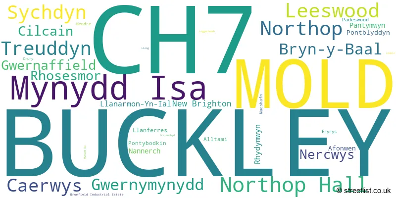
The largest settlement in the CH7 postal code is BUCKLEY followed by MOLD, and MYNYDD ISA.
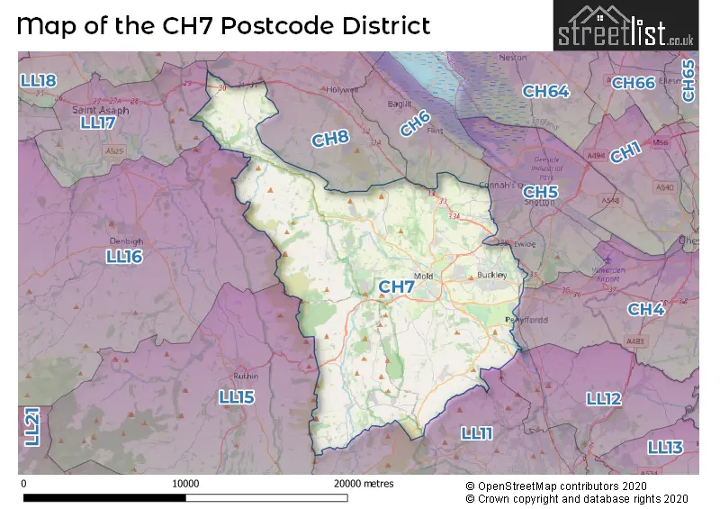
The CH7 Postcode shares a border with CH5 (Connah's Quay, CONNAHS QUAY, Shotton), CH8 (HOLYWELL, GREENFIELD, MOSTYN), CH6 (FLINT, BAGILLT, OAKENHOLT), LL15 (RUTHIN, LLANBEDR DYFFRYN CLWYD, LLANFAIR DYFFRYN CLWYD), LL16 (DENBIGH, LLANDYRNOG, HENLLAN), LL17 (ST ASAPH, ST. ASAPH, RHUALLT), CH4 (CHESTER, SALTNEY, BROUGHTON) and LL11 (WREXHAM, GWERSYLLT, COEDPOETH).
In the CH7 postcode district, the primary settlement is Mold, located in the county of Clwyd in Wales. Other significant settlements within this postcode district include Buckley and Drury, also located in Clwyd. The post town for all these settlements is Mold.
For the district CH7, we have data on 7 postcode sectors. Here's a breakdown: The sector CH7 1, covers Mold in Clwyd. The sector CH7 2, covers Buckley in Clwyd. The sector CH7 3, covers Buckley in Clwyd. The sector CH7 4, covers Leeswood and Treuddyn and Nercwys in Clwyd. The sector CH7 5, covers Caerwys and Cilcain and Gwernaffield in Clwyd. The sector CH7 6, covers Mynydd Isa and Northop Hall and Northop and Sychdyn in Clwyd. The sector CH7 9 is non-geographic. It's often designated for PO Boxes, large organisations, or special services.

Map of the CH7 Postcode District
Explore the CH7 postcode district by using our free interactive map.
When it comes to local government, postal geography often disregards political borders. However, for a breakdown in the CH7 District: the district mostly encompasses the Sir y Fflint - Flintshire (1511 postcodes), and finally, the Sir Ddinbych - Denbighshire area (72 postcodes).
Weather Forecast for CH7
Press Button to Show Forecast for Maeshafn Youth Hostel
| Time Period | Icon | Description | Temperature | Rain Probability | Wind |
|---|---|---|---|---|---|
| 21:00 to 00:00 | Cloudy | 3.0°C (feels like 1.0°C) | 7.00% | NE 7 mph |
Press Button to Show Forecast for Maeshafn Youth Hostel
| Time Period | Icon | Description | Temperature | Rain Probability | Wind |
|---|---|---|---|---|---|
| 00:00 to 03:00 | Cloudy | 3.0°C (feels like 0.0°C) | 8.00% | E 9 mph | |
| 03:00 to 06:00 | Cloudy | 2.0°C (feels like -1.0°C) | 10.00% | ENE 9 mph | |
| 06:00 to 09:00 | Overcast | 3.0°C (feels like 0.0°C) | 11.00% | ENE 9 mph | |
| 09:00 to 12:00 | Cloudy | 5.0°C (feels like 2.0°C) | 8.00% | E 11 mph | |
| 12:00 to 15:00 | Overcast | 6.0°C (feels like 3.0°C) | 48.00% | ENE 9 mph | |
| 15:00 to 18:00 | Overcast | 6.0°C (feels like 3.0°C) | 23.00% | NE 11 mph | |
| 18:00 to 21:00 | Overcast | 6.0°C (feels like 3.0°C) | 18.00% | NE 9 mph | |
| 21:00 to 00:00 | Cloudy | 4.0°C (feels like 1.0°C) | 14.00% | NE 9 mph |
Press Button to Show Forecast for Maeshafn Youth Hostel
| Time Period | Icon | Description | Temperature | Rain Probability | Wind |
|---|---|---|---|---|---|
| 00:00 to 03:00 | Cloudy | 3.0°C (feels like 0.0°C) | 6.00% | NNE 9 mph | |
| 03:00 to 06:00 | Cloudy | 2.0°C (feels like -1.0°C) | 6.00% | N 9 mph | |
| 06:00 to 09:00 | Overcast | 3.0°C (feels like 0.0°C) | 10.00% | NNW 9 mph | |
| 09:00 to 12:00 | Cloudy | 6.0°C (feels like 3.0°C) | 10.00% | NNW 11 mph | |
| 12:00 to 15:00 | Partly cloudy (day) | 8.0°C (feels like 5.0°C) | 8.00% | NW 11 mph | |
| 15:00 to 18:00 | Cloudy | 8.0°C (feels like 6.0°C) | 9.00% | WNW 11 mph | |
| 18:00 to 21:00 | Sunny day | 7.0°C (feels like 5.0°C) | 2.00% | W 9 mph | |
| 21:00 to 00:00 | Clear night | 4.0°C (feels like 1.0°C) | 1.00% | SW 7 mph |
Press Button to Show Forecast for Maeshafn Youth Hostel
| Time Period | Icon | Description | Temperature | Rain Probability | Wind |
|---|---|---|---|---|---|
| 00:00 to 03:00 | Partly cloudy (night) | 4.0°C (feels like 1.0°C) | 2.00% | SSW 9 mph | |
| 03:00 to 06:00 | Cloudy | 4.0°C (feels like 0.0°C) | 7.00% | SSW 9 mph | |
| 06:00 to 09:00 | Partly cloudy (day) | 5.0°C (feels like 2.0°C) | 6.00% | S 9 mph | |
| 09:00 to 12:00 | Cloudy | 9.0°C (feels like 5.0°C) | 8.00% | S 16 mph | |
| 12:00 to 15:00 | Overcast | 10.0°C (feels like 7.0°C) | 16.00% | S 16 mph | |
| 15:00 to 18:00 | Light rain | 11.0°C (feels like 8.0°C) | 45.00% | S 16 mph | |
| 18:00 to 21:00 | Partly cloudy (day) | 10.0°C (feels like 7.0°C) | 11.00% | S 13 mph | |
| 21:00 to 00:00 | Cloudy | 7.0°C (feels like 4.0°C) | 12.00% | SSE 11 mph |
Press Button to Show Forecast for Maeshafn Youth Hostel
| Time Period | Icon | Description | Temperature | Rain Probability | Wind |
|---|---|---|---|---|---|
| 00:00 to 03:00 | Partly cloudy (night) | 6.0°C (feels like 3.0°C) | 11.00% | SSE 11 mph | |
| 03:00 to 06:00 | Cloudy | 6.0°C (feels like 3.0°C) | 10.00% | SE 11 mph | |
| 06:00 to 09:00 | Cloudy | 6.0°C (feels like 3.0°C) | 9.00% | SE 11 mph | |
| 09:00 to 12:00 | Partly cloudy (day) | 9.0°C (feels like 6.0°C) | 8.00% | SE 13 mph | |
| 12:00 to 15:00 | Cloudy | 12.0°C (feels like 9.0°C) | 13.00% | SE 16 mph | |
| 15:00 to 18:00 | Partly cloudy (day) | 13.0°C (feels like 10.0°C) | 10.00% | SE 13 mph | |
| 18:00 to 21:00 | Partly cloudy (day) | 12.0°C (feels like 10.0°C) | 7.00% | SE 9 mph | |
| 21:00 to 00:00 | Partly cloudy (night) | 8.0°C (feels like 7.0°C) | 5.00% | ESE 7 mph |
Where is the CH7 Postcode District?
The postcode district CH7 is located in the town of Mold. Mold is surrounded by several nearby towns, including Buckley to the East (4.60 miles away), Flint to the North East (5.51 miles away), Bagillt to the North (6.78 miles away), Ruthin to the South West (7.19 miles away), Denbigh to the West (9.94 miles away), and St. Asaph to the North West (11.94 miles away). Mold is approximately 172.96 miles away from the centre of London.
The district covers the post towns of BUCKLEY, MOLD.
The sector has postcodes within the nation of Wales.
The CH7 Postcode District is covers the following regions.
- Flintshire and Wrexham - East Wales - Wales
- Conwy and Denbighshire - West Wales - Wales
| Postcode Sector | Delivery Office |
|---|---|
| CH7 1 | Mold Delivery Office |
| CH7 2 | Mold Delivery Office |
| CH7 3 | Mold Delivery Office |
| CH7 4 | Mold Delivery Office |
| CH7 5 | Mold Delivery Office |
| CH7 6 | Mold Delivery Office |
| C | H | 7 | - | X | X | X |
| C | H | 7 | Space | Numeric | Letter | Letter |
Tourist Attractions within the Postcode Area
We found 1 visitor attractions within the CH7 postcode area
| Moel Famau |
|---|
| View Moel Famau on Google Maps |
Current Monthly Rental Prices
| # Bedrooms | Min Price | Max Price | Avg Price |
|---|---|---|---|
| £1,200 | £1,200 | £1,200 | |
| 1 | £550 | £550 | £550 |
| 2 | £725 | £1,200 | £892 |
| 3 | £795 | £1,295 | £954 |
| 4 | £1,395 | £1,395 | £1,395 |
Current House Prices
| # Bedrooms | Min Price | Max Price | Avg Price |
|---|---|---|---|
| £35,000 | £950,000 | £305,714 | |
| 1 | £70,000 | £695,000 | £202,500 |
| 2 | £100,000 | £700,000 | £159,588 |
| 3 | £90,000 | £799,000 | £225,444 |
| 4 | £675,000 | £895,000 | £781,000 |
| 5 | £650,000 | £2,750,000 | £1,094,500 |
| 6 | £695,000 | £800,000 | £747,500 |
| 8 | £1,600,000 | £1,600,000 | £1,600,000 |
| 14 | £2,250,000 | £2,250,000 | £2,250,000 |
Estate Agents who Operate in the CH7 District
| Logo | Name | Brand Name | Address | Contact Number | Total Properties |
|---|---|---|---|---|---|
 | Mold | Cavendish Estate Agents | The Cross, Mold, CH7 1AZ | 01352 872378 | 40 |
 | Mold | Beresford Adams | The Cross, Mold, Flintshire, CH7 1ER | 01352 871186 | 35 |
 | Mold | Williams Estates | 4/4a High Street, Mold, CH7 1AZ | 01352 872359 | 27 |
 | Buckley | William Gleave | 1-3 Mold Road, Buckley, CH7 2JA | 01244 565532 | 27 |
 | Hawarden | Reades | Reades House, 3-5 The Highway, Hawarden, Deeside, CH5 3DG | 01244 537537 | 23 |
- Afon-wen
- Alltami
- Berth-ddu
- Burntwood Pentre
- Bwcle
- Cadole
- Caerwys
- Cilcain
- Coed-Llai
- Coed-talon
- Connah's Quay
- Drury
- Eryrys
- Ewloe Green
- Gwernaffield-y-Waun
- Gwernymynydd
- Hendre
- Licswm
- Little Mountain
- Llan-eurgain
- Llanarmon-yn-Ial
- Llanferres
- Loggerheads
- Maes Maelor
- Maeshafn
- Mold
- Mynydd Isa
- Mynydd y Fflint
- Nannerch
- Nant Alyn
- Nercwys
- New Brighton
- Northop Hall
- Padeswood
- Pantymwyn
- Pontblyddyn
- Pontybodkin
- Rhosesmor
- Rhydymwyn
- Sychdyn
- Tafarn-y-Gelyn
- Treuddyn
- Ysceifiog
| Type of Property | 2018 Average | 2018 Sales | 2017 Average | 2017 Sales | 2016 Average | 2016 Sales | 2015 Average | 2015 Sales |
|---|---|---|---|---|---|---|---|---|
| Detached | £250,290 | 401 | £244,218 | 372 | £232,099 | 404 | £236,921 | 375 |
| Semi-Detached | £153,678 | 279 | £153,246 | 270 | £147,052 | 306 | £143,315 | 277 |
| Terraced | £131,575 | 122 | £133,130 | 124 | £128,691 | 116 | £128,556 | 118 |
| Flats | £100,581 | 37 | £113,011 | 25 | £103,182 | 31 | £102,173 | 26 |