The CH4 postcode district is a postal district located in the CH Chester postcode area with a population of 34,818 residents according to the 2021 England and Wales Census.
The area of the CH4 postcode district is 27.95 square miles which is 72.38 square kilometres or 17,885.75 acres.
Currently, the CH4 district has about 883 postcode units spread across 94 geographic postcode sectors.
Given that each sector allows for 400 unique postcode combinations, the district has a capacity of 37,600 postcodes. With 883 postcodes already in use, this leaves 36717 units available.
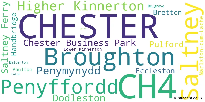
The largest settlement in the CH4 postal code is CHESTER followed by SALTNEY, and BROUGHTON.
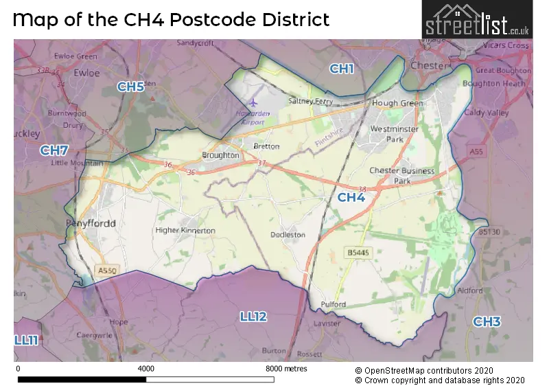
The CH4 Postcode shares a border with LL12 (WREXHAM, LLAY, GRESFORD), CH5 (Connah's Quay, CONNAHS QUAY, Shotton), CH1 (CHESTER, Blacon, Saughall), CH3 (CHESTER, Tattenhall, Vicars Cross) and CH7 (BUCKLEY, MOLD, MYNYDD ISA).
The primary settlement in the CH4 postcode district is Chester, which belongs to the county of Cheshire in England. Other significant settlements in the district include Bretton, Broughton, Penyffordd, Penymynydd, Saltney Ferry, Handbridge, Lache, Saltney, Balderton, Belgrave, Chester Business Park, Dodleston, Eaton, Eccleston, Higher Kinnerton, Lower Kinnerton, Marlston-cum-Lache, Poulton, and Pulford.
For the district CH4, we have data on 4 postcode sectors. Here's a breakdown: The sector CH4 0, covers Broughton and Penyffordd and Penymynydd in Clwyd. The sector CH4 7, covers Chester in Cheshire. The sector CH4 8, covers Chester and Saltney in Cheshire. The sector CH4 8, covers Saltney in Clwyd. The sector CH4 9, covers Higher Kinnerton in Clwyd. The sector CH4 9, covers Dodleston and Chester Business Park and Pulford in Cheshire.
CH4 Postcode Sectors

Map of the CH4 Postcode District
Explore the CH4 postcode district by using our free interactive map.
When it comes to local government, postal geography often disregards political borders. However, for a breakdown in the CH4 District: the district mostly encompasses the Cheshire West and Chester (B) (472 postcodes), and finally, the Sir y Fflint - Flintshire area (439 postcodes).
Weather Forecast for CH4
Press Button to Show Forecast for Hawarden
| Time Period | Icon | Description | Temperature | Rain Probability | Wind |
|---|---|---|---|---|---|
| 09:00 to 12:00 | Cloudy | 7.0°C (feels like 5.0°C) | 7.00% | E 7 mph | |
| 12:00 to 15:00 | Overcast | 9.0°C (feels like 8.0°C) | 13.00% | E 9 mph | |
| 15:00 to 18:00 | Overcast | 10.0°C (feels like 9.0°C) | 12.00% | E 7 mph | |
| 18:00 to 21:00 | Cloudy | 9.0°C (feels like 8.0°C) | 45.00% | N 7 mph | |
| 21:00 to 00:00 | Cloudy | 7.0°C (feels like 6.0°C) | 9.00% | NE 4 mph |
Press Button to Show Forecast for Hawarden
| Time Period | Icon | Description | Temperature | Rain Probability | Wind |
|---|---|---|---|---|---|
| 00:00 to 03:00 | Cloudy | 6.0°C (feels like 5.0°C) | 7.00% | E 4 mph | |
| 03:00 to 06:00 | Cloudy | 5.0°C (feels like 4.0°C) | 8.00% | ENE 4 mph | |
| 06:00 to 09:00 | Cloudy | 5.0°C (feels like 3.0°C) | 7.00% | ENE 4 mph | |
| 09:00 to 12:00 | Overcast | 9.0°C (feels like 7.0°C) | 11.00% | E 9 mph | |
| 12:00 to 15:00 | Overcast | 10.0°C (feels like 8.0°C) | 50.00% | ESE 9 mph | |
| 15:00 to 18:00 | Overcast | 10.0°C (feels like 8.0°C) | 46.00% | NE 9 mph | |
| 18:00 to 21:00 | Overcast | 10.0°C (feels like 8.0°C) | 12.00% | NE 9 mph | |
| 21:00 to 00:00 | Cloudy | 8.0°C (feels like 6.0°C) | 9.00% | NE 4 mph |
Press Button to Show Forecast for Hawarden
| Time Period | Icon | Description | Temperature | Rain Probability | Wind |
|---|---|---|---|---|---|
| 00:00 to 03:00 | Cloudy | 6.0°C (feels like 4.0°C) | 5.00% | NNE 7 mph | |
| 03:00 to 06:00 | Cloudy | 5.0°C (feels like 2.0°C) | 6.00% | N 7 mph | |
| 06:00 to 09:00 | Cloudy | 5.0°C (feels like 3.0°C) | 11.00% | NNW 7 mph | |
| 09:00 to 12:00 | Overcast | 8.0°C (feels like 6.0°C) | 14.00% | NNW 9 mph | |
| 12:00 to 15:00 | Cloudy | 10.0°C (feels like 8.0°C) | 12.00% | NW 11 mph | |
| 15:00 to 18:00 | Partly cloudy (day) | 11.0°C (feels like 9.0°C) | 8.00% | WNW 11 mph | |
| 18:00 to 21:00 | Sunny day | 11.0°C (feels like 9.0°C) | 3.00% | W 9 mph | |
| 21:00 to 00:00 | Clear night | 8.0°C (feels like 5.0°C) | 1.00% | SW 7 mph |
Press Button to Show Forecast for Hawarden
| Time Period | Icon | Description | Temperature | Rain Probability | Wind |
|---|---|---|---|---|---|
| 00:00 to 03:00 | Partly cloudy (night) | 6.0°C (feels like 4.0°C) | 1.00% | SSW 7 mph | |
| 03:00 to 06:00 | Cloudy | 5.0°C (feels like 2.0°C) | 4.00% | SSE 7 mph | |
| 06:00 to 09:00 | Partly cloudy (day) | 6.0°C (feels like 3.0°C) | 1.00% | SSE 7 mph | |
| 09:00 to 12:00 | Partly cloudy (day) | 11.0°C (feels like 8.0°C) | 3.00% | S 11 mph | |
| 12:00 to 15:00 | Cloudy | 13.0°C (feels like 10.0°C) | 7.00% | S 13 mph | |
| 15:00 to 18:00 | Cloudy | 14.0°C (feels like 11.0°C) | 10.00% | S 13 mph | |
| 18:00 to 21:00 | Cloudy | 13.0°C (feels like 11.0°C) | 8.00% | SSE 11 mph | |
| 21:00 to 00:00 | Partly cloudy (night) | 11.0°C (feels like 8.0°C) | 2.00% | SSE 9 mph |
Press Button to Show Forecast for Hawarden
| Time Period | Icon | Description | Temperature | Rain Probability | Wind |
|---|---|---|---|---|---|
| 00:00 to 03:00 | Partly cloudy (night) | 9.0°C (feels like 6.0°C) | 4.00% | SE 9 mph | |
| 03:00 to 06:00 | Cloudy | 7.0°C (feels like 5.0°C) | 6.00% | SE 9 mph | |
| 06:00 to 09:00 | Cloudy | 8.0°C (feels like 5.0°C) | 6.00% | SE 7 mph | |
| 09:00 to 12:00 | Sunny day | 12.0°C (feels like 10.0°C) | 4.00% | SE 11 mph | |
| 12:00 to 15:00 | Cloudy | 15.0°C (feels like 12.0°C) | 11.00% | SE 13 mph | |
| 15:00 to 18:00 | Cloudy | 16.0°C (feels like 13.0°C) | 13.00% | SE 13 mph | |
| 18:00 to 21:00 | Partly cloudy (day) | 15.0°C (feels like 13.0°C) | 6.00% | SE 9 mph | |
| 21:00 to 00:00 | Cloudy | 12.0°C (feels like 11.0°C) | 7.00% | ESE 7 mph |
Where is the CH4 Postcode District?
The postcode district CH4 is located in the town of Chester. It is situated near several towns, including Deeside to the North West (4.83 miles away), Buckley to the West (5.27 miles away), Ellesmere Port to the North (9.49 miles away), Wrexham to the South West (11.47 miles away), and Malpas to the South East (12.01 miles away). Additionally, the distance from Chester to the center of London is approximately 165.04 miles.
The district is within the post town of CHESTER.
The sector has postcodes within the nations of Wales, England.
The CH4 Postcode District is covers the following regions.
- Flintshire and Wrexham - East Wales - Wales
- Cheshire West and Chester - Cheshire - North West (England)
Postcode Sectors within the CH4 District
- CH4 0
- CH4 7
- CH4 8
- CH4 9
- CH41 0
- CH41 1
- CH41 2
- CH41 3
- CH41 4
- CH41 5
- CH41 6
- CH41 7
- CH41 8
- CH41 9
- CH42 0
- CH42 1
- CH42 2
- CH42 3
- CH42 4
- CH42 5
- CH42 6
- CH42 7
- CH42 8
- CH42 9
- CH43 0
- CH43 1
- CH43 2
- CH43 3
- CH43 4
- CH43 5
- CH43 6
- CH43 7
- CH43 8
- CH43 9
- CH44 0
- CH44 1
- CH44 2
- CH44 3
- CH44 4
- CH44 5
- CH44 6
- CH44 7
- CH44 8
- CH44 9
- CH45 0
- CH45 1
- CH45 2
- CH45 3
- CH45 4
- CH45 5
- CH45 6
- CH45 7
- CH45 8
- CH45 9
- CH46 0
- CH46 1
- CH46 2
- CH46 3
- CH46 4
- CH46 5
- CH46 6
- CH46 7
- CH46 8
- CH46 9
- CH47 0
- CH47 1
- CH47 2
- CH47 3
- CH47 4
- CH47 5
- CH47 6
- CH47 7
- CH47 8
- CH47 9
- CH48 0
- CH48 1
- CH48 2
- CH48 3
- CH48 4
- CH48 5
- CH48 6
- CH48 7
- CH48 8
- CH48 9
- CH49 0
- CH49 1
- CH49 2
- CH49 3
- CH49 4
- CH49 5
- CH49 6
- CH49 7
- CH49 8
- CH49 9
| Postcode Sector | Delivery Office |
|---|---|
| CH4 0 | Chester Delivery Office |
| CH4 7 | Chester Delivery Office |
| CH4 8 | Chester Delivery Office |
| CH4 9 | Chester Delivery Office |
| C | H | 4 | - | X | X | X |
| C | H | 4 | Space | Numeric | Letter | Letter |
Current Monthly Rental Prices
| # Bedrooms | Min Price | Max Price | Avg Price |
|---|---|---|---|
| £450 | £450 | £450 | |
| 1 | £595 | £995 | £763 |
| 2 | £800 | £995 | £874 |
| 3 | £950 | £1,750 | £1,294 |
| 4 | £1,500 | £4,000 | £2,590 |
Current House Prices
| # Bedrooms | Min Price | Max Price | Avg Price |
|---|---|---|---|
| £870,000 | £870,000 | £870,000 | |
| 3 | £240,000 | £240,000 | £240,000 |
| 4 | £700,000 | £1,600,000 | £932,273 |
| 5 | £895,000 | £1,150,000 | £1,032,500 |
| 6 | £750,000 | £1,750,000 | £1,096,429 |
Estate Agents who Operate in the CH4 District
| Logo | Name | Brand Name | Address | Contact Number | Total Properties |
|---|---|---|---|---|---|
 | Chester | Town & Country Estate Agents | 33 Lower Bridge Street, Chester, CH1 1RS | 01244 565373 | 19 |
 | Chester | Beresford Adams | 1-3 Friarsgate Grosvenor Street Chester CH1 1XG | 01244 565206 | 18 |
 | Chester | Cavendish Estate Agents | 14 Grosvenor Street, Chester CH1 2DD | 01244 565221 | 12 |
 | Chester | Savills | 22 Lower Bridge Street, Chester, CH1 1RS | 01244 565088 | 12 |
 | covering Chester & Wirral | Purplebricks | Suite 7 First Floor Cranmore Drive Shirley Solihull B90 4RZ | 020 3834 8327 | 12 |
| Type of Property | 2018 Average | 2018 Sales | 2017 Average | 2017 Sales | 2016 Average | 2016 Sales | 2015 Average | 2015 Sales |
|---|---|---|---|---|---|---|---|---|
| Detached | £318,349 | 227 | £322,158 | 195 | £305,450 | 271 | £291,435 | 292 |
| Semi-Detached | £194,294 | 232 | £192,999 | 251 | £186,566 | 261 | £173,339 | 278 |
| Terraced | £181,745 | 118 | £171,086 | 130 | £165,939 | 162 | £168,759 | 137 |
| Flats | £143,359 | 46 | £157,975 | 44 | £130,447 | 60 | £120,716 | 38 |