This section of the site is all about the CH Postcode area, also known as the Chester Postal Area. Explore links to the next level to learn more about specific postcode districts such as CH1.
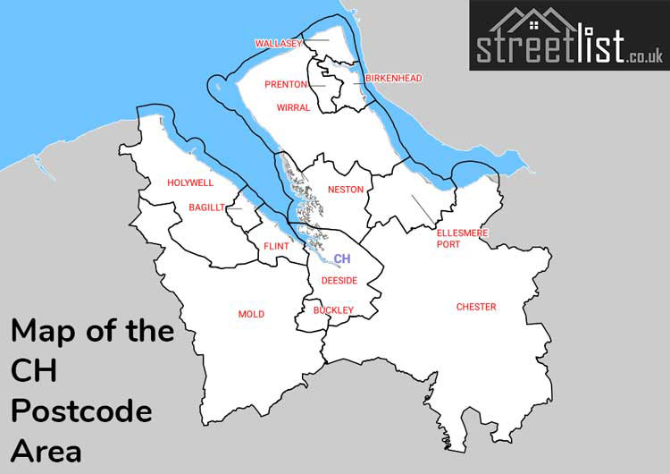
Map of the CH Postcode for Chester
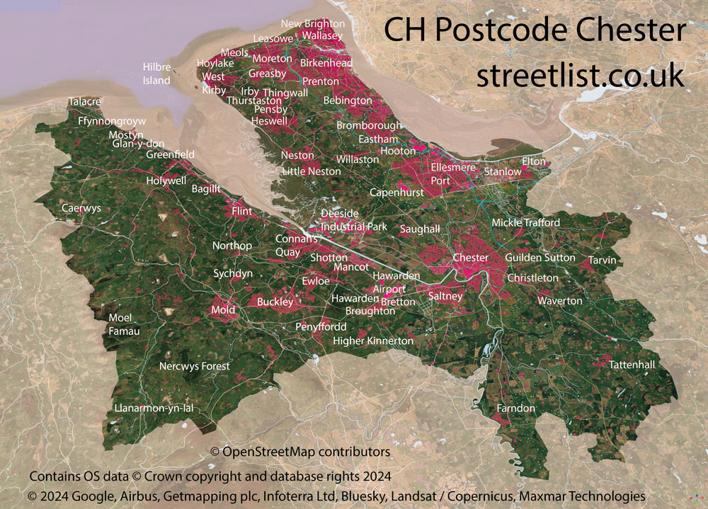
The CH postcode area represents a group of postal districts in the Chester area of the United Kingdom. The area code CH stands for the letters c and h in CHester. CH has a population of 659,743 and covers an area of 1,002,123 hectares. Fun fact: 1.01% of the population of Great Britain lives in this area.
The postcode area falls within the following counties: Merseyside (45.67%), Cheshire (32.62%), Clwyd (21.71%).
Post Towns and Postcode Districts for the CH Postcode
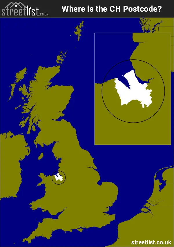
Where is the CH Postcode Area?
The CH Chester postcode has it's West in Wales and it's East is in North West of England. The postal area borders the following neighbouring postal areas: LL - Llandudno, CW - Crewe, SY - Shrewsbury, WA - Warrington and L - Liverpool, It also borders The Irish Sea, The Mersey and Dee Estuary.
Map of the CH Chester Postcode Area
Explore the CH Chester postcode area by using our interactive map.
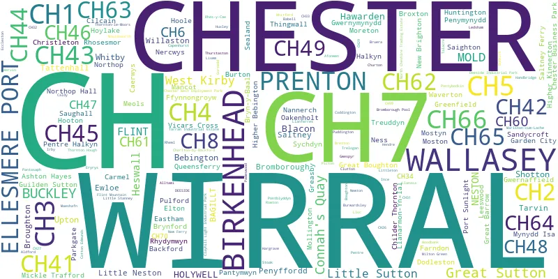
Postcode Districts within the CH Chester Postcode Area
There are 24 postcode districts within the Chester postcode area
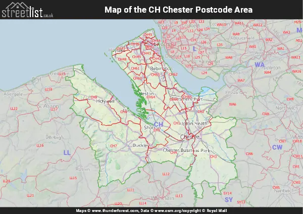
A map showing the boundary of in relation to other areas
There are 15 towns within the Chester postcode area.
| Unit | Area² |
|---|---|
| Hectares | 1,002,123² |
| Miles | 3,869² |
| Feet | 107,867,517,597² |
| Kilometres | 10,021² |
Postal Delivery Offices serving the CH Chester Postcode Area
- Birkenhead Delivery Office
- Chester Delivery Office
- Deeside Delivery Office
- Ellesmere Port Delivery Office
- Flint Delivery Office
- Heswall Delivery Office
- Hoylake Delivery Office
- Mold Delivery Office
- Moreton Delivery Office
- Neston Delivery Office
- New Ferry Delivery Office
- Prenton Delivery Office
- Upton (ch) Delivery Office
- Wallasey Delivery Office
Councils with Postcodes in CH
Towns and Villages within the CH Chester Postcode Area
- Afon-wen - village
- Aldford - village
- Alltami - village
- Ashton Hayes - village
- Aston - village
- Babell - village
- Backford - village
- Bagillt - village
- Barnston - village
- Bebington - town
- Berth-ddu - village
- Berthengam - village
- Big Mancot - village
- Birkenhead - town
- Bretton - village
- Broughton - village
- Brown Knowl - village
- Brynford - village
- Burntwood Pentre - village
- Burton - village
- Burwardsley - village
- Bwcle / Buckley - town
- Cadole - village
- Caerwys - town
- Calcoed - village
- Caldy - village
- Capenhurst - village
- Chester - city
- Childer Thornton - village
- Christleton - village
- Churton - village
- Cilcain - village
- Clutton - village
- Coddington - otherSettlement
- Coed-talon - village
- Connah's Quay / Cei Connah - town
- Dodleston - village
- Drury - village
- Eccleston - village
- Ellesmere Port - town
- Elton - village
- Eryrys - village
- Ewloe - village
- Ewloe Green - village
- Farndon - village
- Ffynnongroyw - village
- Flint / Y Fflint - town
- Flint Mountain - village
- Fuller's Moor - village
- Garden City - village
- Gorsedd - village
- Greasby - village
- Great Barrow - village
- Greenfield / Maes-Glas - village
- Guilden Sutton - village
- Gwernaffield-y-Waun - village
- Gwernymynydd - village
- Gwespyr - village
- Hargrave - village
- Hawarden - village
- Helygain / Halkyn - village
- Heswall - town
- Higher Kinnerton - village
- Holywell - town
- Hoole Bank - village
- Hooton - village
- Hoylake - town
- Huxley - village
- Ince - village
- Ledsham - otherSettlement
- Leeswood - village
- Licswm / Lixwm - village
- Little Mancot - village
- Little Mountain - village
- Littleton - village
- Llan-eurgain / Northop - village
- Llanarmon-yn-Ial - village
- Llanasa - village
- Llanferres - village
- Lloc - village
- Lower Kinnerton - village
- Maeshafn - village
- Mancot Royal - village
- Meols - village
- Mickle Trafford - village
- Milton Green - village
- Mold / Yr Wyddgrug - town
- Mollington - village
- Moston - village
- Mostyn - village
- Mouldsworth - village
- Mynydd Isa - village
- Nannerch - village
- Nercwys - village
- Neston - town
- New Brighton - village
- Northop Hall - village
- Old Warren - village
- Oscroft - village
- Padeswood - village
- Pantasaph - village
- Pantymwyn - village
- Pen-y-ffordd - village
- Pentre - village
- Pentre Halkyn / Pentre Helygain - village
- Penyffordd - village
- Piper's Ash - village
- Pontblyddyn - village
- Pontybodkin - village
- Poulton - village
- Puddington - village
- Pulford - village
- Queensferry / Y Fferi Isaf - village
- Rhes-y-cae - village
- Rhosesmor - village
- Rhydymwyn - village
- Rowton - village
- Saighton - village
- Sandycroft - village
- Saughall - village
- Shotton - town
- Stoak - village
- Storeton - village
- Sychdyn / Soughton - village
- Talacre - village
- Tarvin - village
- Tarvin Sands - village
- Tattenhall - village
- Thornton Hough - village
- Thornton-le-Moors - village
- Thurstaston - village
- Trelogan - village
- Treuddyn - village
- Vicarscross - village
- Wallasey - town
- Walwen - village
- Waverton - village
- Wervin - village
- West Kirby - town
- Whelston - village
- Whitford - village
- Willaston - village
- Ysceifiog - village