This section of the site is all about the WA Postcode area, also known as the Warrington Postal Area. Explore links to the next level to learn more about specific postcode districts such as WA1.

The WA postcode area represents a group of postal districts in the Warrington area of the United Kingdom. The area code WA stands for the letters w and a in WArrington. WA has a population of 616,180 and covers an area of 720,400 hectares. Fun fact: 0.95% of the population of Great Britain lives in this area.
The postcode area falls within the following counties: Cheshire (59.76%), Merseyside (22.59%), Greater Manchester (17.64%), Lancashire (0.02%).
Post Towns and Postcode Districts for the WA Postcode
Where is the WA Postcode Area?
The Warrington WA Postcode is in the North West of England. The postal area borders the following neighbouring postal areas: CW - Crewe, WN - Wigan, SK - Stockport, CH - Chester, L - Liverpool and M - Manchester, It also borders The Mersey,
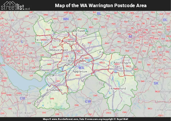
Map of the WA Warrington Postcode Area
Explore the WA Warrington postcode area by using our interactive map.


Postcode Districts within the WA Warrington Postcode Area
There are 16 postcode districts within the Warrington postcode area
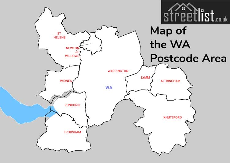
A map showing the boundary of in relation to other areas
There are 16 towns within the Warrington postcode area.
| Unit | Area² |
|---|---|
| Hectares | 720,400² |
| Miles | 2,781² |
| Feet | 77,543,135,600² |
| Kilometres | 7,204² |
Postal Delivery Offices serving the WA Warrington Postcode Area
- Altrincham Delivery Office
- Birchwood Delivery Office
- Frodsham Delivery Office
- Knutsford Delivery Office
- Lymm Scale Payment Delivery Office
- Newton Le Willows Delivery Office
- Runcorn Delivery Office
- St Helens Delivery Office
- Warrington Delivery Office
- Widnes Delivery Office
Councils with Postcodes in WA
Towns and Villages within the WA Warrington Postcode Area
- Allostock - village
- Altrincham - town
- Alvanley - village
- Appleton Thorn - village
- Ashley - village
- Ashton-in-Makerfield - town
- Bold Heath - village
- Bowdon - Urban Area
- Broomedge - village
- Bucklow Hill - village
- Burtonwood - village
- Collins Green - village
- Crank - village
- Croft - village
- Cronton - village
- Culcheth - village
- Daresbury - village
- Dunham Town - village
- Dunham Woodhouses - village
- Dunham-on-the-Hill - village
- Dutton - village
- Frodsham - town
- Glazebrook - village
- Glazebury - village
- Golborne - town
- Hale - town
- Hale Bank - village
- Hatchmere - village
- Hatton - village
- Haydock - town
- Heatley - village
- Helsby - village
- High Legh - village
- Higher Walton - village
- Higher Whitley - village
- Hollinfare - village
- Hollins Green - village
- Hoo Green - village
- Irlam - town
- Kings Moss - village
- Kingsley - village
- Knolls Green - village
- Knutsford - town
- Lane End - village
- Little Bollington - village
- Lower Peover - village
- Lower Stretton - village
- Lower Whitley - village
- Lymm - town
- Manley - village
- Mere - village
- Mobberley - village
- Moore - village
- New Lane End - village
- New Mills - village
- Newton-le-Willows - town
- Norley - village
- Ollerton - village
- Over Peover - village
- Peover Heath - village
- Pewfall - village
- Pickmere - village
- Plumley - village
- Rainford - town
- Rainford Junction - village
- Rostherne - village
- Rudheath Woods - village
- Runcorn - town
- Sale - town
- Snelson - village
- St Helens - town
- Stretton - village
- Sutton Weaver - village
- Swan Green - village
- Town of Lowton - village
- Warburton - village
- Warrington - town
- Widnes - town
- Winwick - village
- Wythenshawe - Urban Area