This section of the site is all about the SK Postcode area, also known as the Stockport Postal Area. Explore links to the next level to learn more about specific postcode districts such as SK1.
The SK postcode area represents a group of postal districts in the Stockport area of the United Kingdom. The area code SK stands for the letters s and k in StocKport. SK has a population of 603,795 and covers an area of 1,164,009 hectares. Fun fact: 0.93% of the population of Great Britain lives in this area.
The postcode area falls within the following counties: Greater Manchester (57.81%), Cheshire (24.82%), Derbyshire (16.59%), Staffordshire (0.78%).
Post Towns and Postcode Districts for the SK Postcode
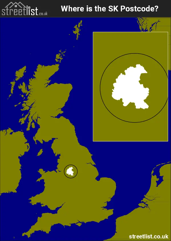
Where is the SK Postcode Area?
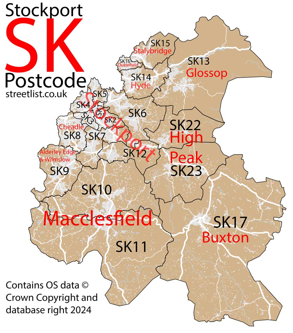
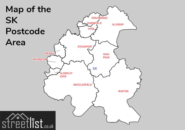
The Stockport SK Postcode area encompasses 19 postcode districts in the North West of England. Stockport, the largest post town in the area, includes eight districts and lies predominantly in Greater Manchester, along with Cheadle, Dukinfield, Stalybridge, and Hyde. Meanwhile, Macclesfield and Wilmslow are situated in Cheshire, while Buxton, High Peak, and Glossop are located in Derbyshire. The postcode area spans 30 miles at its widest point. The northwestern section adjoining Manchester is the most urbanised, whereas the southeastern part incorporates the scenic Peak District National Park.
The SK Stockport Postcode is in the North West of England. The postal area borders the following neighbouring postal areas: DE - Derby, HD - Huddersfield, CW - Crewe, ST - Stoke-on-Trent, OL - Oldham, WA - Warrington, S - Sheffield and M - Manchester, and is located inland.
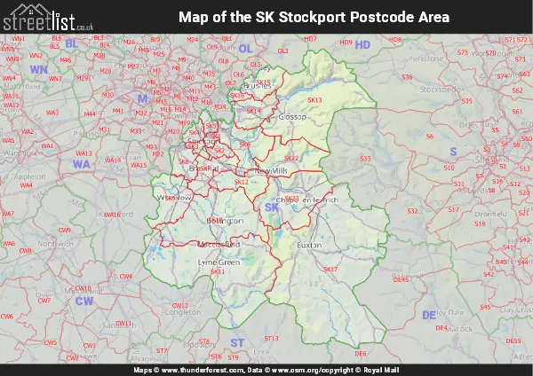
Map of the SK Stockport Postcode Area
Explore the SK Stockport postcode area by using our interactive map.
Postcode Districts within the SK Stockport Postcode Area
There are 19 postcode districts within the Stockport postcode area
A map showing the boundary of in relation to other areas
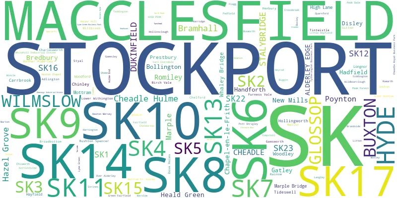
There are 23 towns within the Stockport postcode area.
| Unit | Area² |
|---|---|
| Hectares | 1,164,009² |
| Miles | 4,494² |
| Feet | 125,292,764,751² |
| Kilometres | 11,640² |
Postal Delivery Offices serving the SK Stockport Postcode Area
- Alderley Edge Delivery Office
- Ashton Under Lyne Delivery Office
- Birchvale Scale Payment Delivery Office
- Bramhall Delivery Office
- Bredbury Delivery Office
- Buxton (sk) Delivery Office
- Chapel En Le Frith Scale Payment Delivery Office
- Cheadle (sk) Delivery Office
- Cheadle Hulme Delivery Office
- Chinley Scale Payment Delivery Office
- Disley Scale Payment Delivery Office
- Glossop Delivery Office
- Hadfield Scale Payment Delivery Office
- Hayfield Scale Payment Delivery Office
- Hazel Grove Delivery Office
- Hyde Delivery Office
- Macclesfield Delivery Office
- Marple Delivery Office
- Stockport 1 Delivery Office
- Stockport 2 Delivery Office
- Stockport 3 Delivery Office
- Stockport 4 Delivery Office
- Stockport 5 Delivery Office
- Stockport Central Delivery Office
- Tideswell Scale Payment Delivery Office
- Whaley Bridge Scale Payment Delivery Office
- Wilmslow Delivery Office
Councils with Postcodes in SK
Towns and Villages within the SK Stockport Postcode Area
- Adder's Moss - village
- Adlington - village
- Alderley Edge - village
- Ashton-under-Lyne - town
- Audenshaw - Urban Area
- Biggin - village
- Birch Vale - village
- Bollington - town
- Bosley - village
- Bramhall - town
- Bredbury - Urban Area
- Broadbottom - village
- Brookhouse - village
- Butley Town - village
- Buxton - town
- Buxworth - village
- Chapel-en-le-Frith - town
- Charlesworth - village
- Cheadle - town
- Cheadle Hulme - town
- Chelford - village
- Chelmorton - village
- Chinley - village
- Chisworth - village
- Combs - village
- Compstall - village
- Cressbrook - village
- Dean Row - village
- Denton - town
- Dinting Vale - village
- Disley - village
- Dove Holes - village
- Dukinfield - town
- Earl Sterndale - village
- Flagg - village
- Furness Vale - village
- Gamesley - village
- Gatley - town
- Gawsworth - village
- Glossop - town
- Great Hucklow - village
- Great Warford - village
- Hadfield - village
- Hague Bar - village
- Handforth - village
- Harpur Hill - village
- Hartington - village
- Hattersley - village
- Hayfield - village
- Hazel Grove - town
- Heald Green - Urban Area
- Henbury - village
- High Lane - village
- Higher Hurdsfield - village
- Higher Poynton - village
- Hollingworth - village
- Hollinsclough - otherSettlement
- Hope Green - otherSettlement
- Hyde - town
- Jodrell Bank - village
- Kettleshulme - village
- Ladmanlow - village
- Langley - village
- Leaden Knowl - village
- Lee Head - village
- Little Hayfield - village
- Litton - village
- Longnor - village
- Lower Withington - village
- Macclesfield - town
- Manchester - city
- Marple - town
- Marple Bridge - village
- Marpleridge - village
- Marton - village
- Mellor - village
- Middlewood - village
- Mill Brow - village
- Morley - village
- Mossley - town
- Mottram in Longdendale - village
- Mottram St Andrew - village
- Nether Alderley - village
- New Mills - town
- New Smithy - village
- Padfield - village
- Peak Forest - village
- Peover Heath - village
- Poynton - town
- Prestbury - village
- Rainow - village
- Reddish - Urban Area
- Romiley - town
- Rushton Bank - village
- Rushton Spencer - village
- Shawfield - otherSettlement
- Sheen - village
- Siddington - village
- Snelson - village
- Sparrowpit - village
- Stalybridge - town
- Stockport - town
- Strines - village
- Styal - village
- Sutton Lane Ends - village
- Taddington - village
- Thornsett - village
- Tideswell - village
- Tintwistle - village
- Tunstead Milton - village
- Upper End - village
- Wardsend - village
- Warslow - village
- Whaley Bridge - town
- Whirley Grove - village
- Wilmslow - town
- Wood Lanes - village
- Woodford - village
- Woodley - village
- Wythenshawe - Urban Area