This section of the site is all about the S Postcode area, also known as the Sheffield Postal Area. Explore links to the next level to learn more about specific postcode districts such as S1.

The S postcode area represents a group of postal districts in the Sheffield area of the United Kingdom. The area code S stands for the letters s in Sheffield. S has a population of 1,358,507 and covers an area of 1,797,716 hectares. Fun fact: 2.09% of the population of Great Britain lives in this area.
The postcode area falls within the following counties: South Yorkshire (75.66%), Derbyshire (19.22%), Nottinghamshire (4.87%), West Yorkshire (0.24%).
Post Towns and Postcode Districts for the S Postcode
-
S1 South YorkshireS2 South YorkshireS3 South YorkshireS4 South YorkshireS5 South YorkshireS6 South YorkshireS7 South YorkshireS8 South YorkshireS9 South YorkshireS10 South YorkshireS11 South YorkshireS12 Derbyshire (2%), South Yorkshire (97%)S13 South YorkshireS14 South YorkshireS17 South YorkshireS20 South YorkshireS21 Derbyshire (94%), South Yorkshire (5%)S25 South YorkshireS26 South YorkshireS35 South YorkshireS36 South YorkshireS95 S96 S97 S98 S99
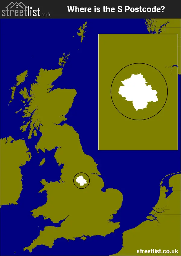
Where is the S Postcode Area?
The S Sheffield Postcode has it's North in the Yorkshire and the Humber region and it's South is in the East Midlands of England. The postal area borders the following neighbouring postal areas: DE - Derby, HD - Huddersfield, SK - Stockport, WF - Wakefield, NG - Nottingham and DN - Doncaster, and is located inland.
Map of the S Sheffield Postcode Area
Explore the S Sheffield postcode area by using our interactive map.
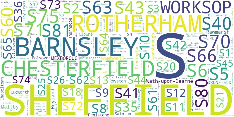
Postcode Districts within the S Sheffield Postcode Area
There are 45 postcode districts within the Sheffield postcode area

A map showing the boundary of in relation to other areas
There are 22 towns within the Sheffield postcode area.

| Unit | Area² |
|---|---|
| Hectares | 1,797,716² |
| Miles | 6,941² |
| Feet | 193,504,352,524² |
| Kilometres | 17,977² |
Postal Delivery Offices serving the S Sheffield Postcode Area
- Bamford Scale Payment Delivery Office
- Barnsley Delivery Office
- Birdwell Scale Payment Delivery Office
- Bolsover Delivery Office
- Bradwell Scale Payment Delivery Office
- Brierley Scale Payment Delivery Office
- Calver Scale Payment Delivery Office
- Carlton-in-lindrick Scale Payment Delivery Office
- Chapeltown Delivery Office
- Chesterfield Delivery Office
- Creswell Scale Payment Delivery Office
- Cudworth Scale Payment Delivery Office
- Dinnington Delivery Office
- Dore Delivery Office
- Dronfield Delivery Office
- Eyam Scale Payment Delivery Office
- Grimethorpe Scale Payment Delivery Office
- Grindleford Scale Payment Delivery Office
- Halfway Delivery Office
- Hathersage Scale Payment Delivery Office
- Hope Scale Payment Delivery Office
- Maltby Delivery Office
- Manvers Delivery Office
- Penistone Scale Payment Delivery Office
- Rotherham Delivery Office
- Sheffield City 2 Delivery Office
- Sheffield Delivery Office
- Sheffield E Postal Delivery Office
- Sheffield N Postal Delivery Office
- Sheffield Ne Postal Delivery Office
- Sheffield Scale Payment Delivery Office
- Sheffield Se Postal Delivery Office
- Sheffield Sw Postal Delivery Office
- Sheffield W Postal Delivery Office
- South Hiendley Scale Payment Delivery Office
- Staveley Delivery Office
- Stocksbridge Delivery Office
- Stoney Middleton Scale Payment Delivery Office
- Tanksersley Scale Payment Delivery Office
- Wombwell Delivery Office
- Worksop Delivery Office
Councils with Postcodes in S
Towns and Villages within the S Sheffield Postcode Area
- Adwick upon Dearne - village
- Alton - village
- Apperknowle - village
- Arkwright Town - village
- Ashgate - otherSettlement
- Ashover - village
- Aston - village
- Aughton - village
- Bamford - village
- Barlborough - village
- Barlow - village
- Barnsley - town
- Barrow Hill - village
- Barugh - village
- Barugh Green - village
- Billingley - village
- Birdwell - village
- Blacker Hill - village
- Blyth - village
- Bolsover - town
- Bolsterstone - village
- Bolton upon Dearne - town
- Bradwell - village
- Braithwell - village
- Bramley - village
- Brampton - village
- Brampton en le Morthen - village
- Brecks - village
- Brierley - village
- Brimington - village
- Brinsworth - village
- Broomhill - village
- Calow - village
- Calow - village
- Calver - village
- Carburton - otherSettlement
- Carlton - village
- Carlton Forest - otherSettlement
- Carlton in Lindrick - village
- Castleton - village
- Catcliffe - village
- Cawthorne - village
- Chapeltown - Settlement
- Chesterfield - town
- Clay Cross - town
- Clifton - village
- Clowne - village
- Cock Alley - village
- Common Side - village
- Crane Moor - village
- Creswell - village
- Crow Edge - village
- Cudworth - village
- Curbar - village
- Cutthorpe - village
- Dalton - village
- Dalton Parva - village
- Darfield - village
- Darton - village
- Deepcar - village
- Dinnington - town
- Dodworth - village
- Doe Lea - village
- Dronfield - town
- Duckmanton - village
- Dungworth - village
- Ecclesfield - village
- Eckington - village
- Edale - village
- Elmton - village
- Elsecar - village
- Eyam - village
- Firbeck - village
- Flanderwell - village
- Foolow - village
- Froggatt - village
- Gawber - village
- Glapwell - village
- Goldthorpe - town
- Grassmoor - village
- Greasbrough - village
- Great Houghton - village
- Green Moor - village
- Grenoside - village
- Grimethorpe - village
- Grindleford - village
- Haigh - village
- Hardstoft - village
- Hardwick Wood - village
- Harley - village
- Harthill - village
- Hathersage - village
- Heath - village
- Hellaby - village
- Hemingfield - village
- High Green - Settlement
- High Hoyland - village
- Higham - village
- Highlane - village
- Hodthorpe - village
- Holmesfield - village
- Holmewood - village
- Holymoorside - village
- Hood Green - village
- Hooton Levitt - village
- Hooton Roberts - village
- Hope - village
- Howbrook - village
- Hoyland - Settlement
- Hoylandswaine - village
- Hundall - village
- Ingbirchworth - village
- Jump - village
- Kelstedge - village
- Kexbrough - village
- Killamarsh - Settlement
- Kilnhurst - village
- Kiveton Park - village
- Langold - village
- Laughton en le Morthen - village
- Letwell - village
- Listerdale - village
- Little Houghton - village
- Littlemoor - village
- Long Duckmanton - village
- Low Bradfield - village
- Lower Pilsley - village
- Maltby - town
- Markham Vale - Settlement
- Marsh Lane - village
- Mexborough - town
- Micklebring - village
- Middle Handley - village
- Middlecliffe - village
- Midhopestones - village
- Millhouse Green - village
- Millthorpe - village
- Milltown - village
- Nether Padley - village
- North Anston - village
- North Wingfield - village
- Old Tupton - village
- Oldcotes - village
- Oughtibridge - village
- Oxspring - village
- Palterton - village
- Penistone - town
- Pilley - village
- Pilsley - village
- Platts Common - village
- Ranby - village
- Ravenfield - village
- Ravenfield Common - village
- Rawmarsh - town
- Redbrook - village
- Renishaw - village
- Rhodesia - village
- Ridgeway - village
- Rotherham - town
- Royston - town
- Scarcliffe - village
- Scholes - village
- Shafton - village
- Sheffield - city
- Shireoaks - village
- Shuttlewood - village
- Silkstone - village
- Silkstone Common - village
- Slack - otherSettlement
- South Anston - village
- South Hiendley - village
- South Kirkby - town
- Spinkhill - village
- Stainborough - village
- Staincross - village
- Stainton - village
- Stanfree - village
- Staveley - town
- Stocksbridge - town
- Stoney Middleton - village
- Sunnyside - village
- Sutton Scarsdale - village
- Swallownest - village
- Swinton - Settlement
- Tankersley - village
- Temple Normanton - village
- Thorpe Common - village
- Thorpe Hesley - village
- Thorpe Salvin - village
- Thrybergh - village
- Thurcroft - village
- Thurgoland - village
- Thurlstone - village
- Thurnscoe - town
- Todwick - village
- Treeton - village
- Tupton - village
- Ulley - village
- Unstone - village
- Unstone Green - village
- Upper Newbold - village
- Upper Tankersley - village
- Wadshelf - village
- Wales - village
- Wath upon Dearne - town
- Waverley - Settlement
- Wentworth - village
- Wharncliffe Side - village
- Whiston - village
- Whitwell - village
- Wickersley - village
- Wingerworth - village
- Wombwell - town
- Woodall - village
- Woodsetts - village
- Woodthorpe - village
- Woolley Grange - village
- Worksop - town
- Worrall - village
- Worsbrough - town
- Wortley - village