The S2 postcode district is a postal district located in the S Sheffield postcode area with a population of 46,993 residents according to the 2021 England and Wales Census.
The area of the S2 postcode district is 3.93 square miles which is 10.17 square kilometres or 2,513.58 acres.
Currently, the S2 district has about 967 postcode units spread across 30 geographic postcode sectors.
Given that each sector allows for 400 unique postcode combinations, the district has a capacity of 12,000 postcodes. With 967 postcodes already in use, this leaves 11033 units available.
The largest settlements in the S2 postal code are SHEFFIELD and Park Hill.
The S2 Postcode shares a border with S1 (SHEFFIELD), S12 (SHEFFIELD, Ridgeway, Hackenthorpe), S13 (SHEFFIELD, Woodhouse, Handsworth), S14 (SHEFFIELD), S8 (SHEFFIELD), S9 (SHEFFIELD, Tinsley) and S4 (SHEFFIELD).
The primary settlement in the S2 postcode district is Sheffield, which is located in the county of South Yorkshire. Other significant settlements in this postcode district include Heeley and Park Hill. The post town for the S2 postcode district is Sheffield.
For the district S2, we have data on 6 postcode sectors. Here's a breakdown: The sector S2 1, covers Sheffield in South Yorkshire. The sector S2 2, covers Sheffield in South Yorkshire. The sector S2 3, covers Sheffield in South Yorkshire. The sector S2 4, covers Sheffield in South Yorkshire. The sector S2 5, covers Sheffield in South Yorkshire. The sector S2 9 is non-geographic. It's often designated for PO Boxes, large organisations, or special services.

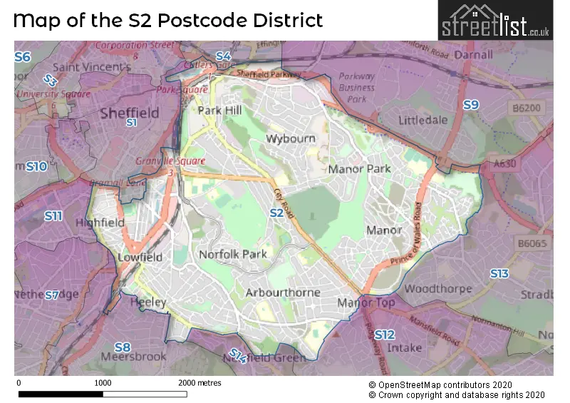
Map of the S2 Postcode District
Explore the S2 postcode district by using our free interactive map.
When it comes to local government, postal geography often disregards political borders. However, for a breakdown in the S2 District: the district mostly encompasses the Sheffield District (B) area with a total of 980 postcodes.
Recent House Sales in S2
| Date | Price | Address |
|---|---|---|
| 24/10/2023 | £315,000 | Park Spring Drive, Sheffield, S2 3QS |
| 11/10/2023 | £70,750 | Priestley Street, Sheffield, S2 4FT |
| 06/10/2023 | £91,902 | Priestley Street, Sheffield, S2 4FT |
| 06/10/2023 | £65,500 | Priestley Street, Sheffield, S2 4FT |
| 29/09/2023 | £69,750 | Priestley Street, Sheffield, S2 4FT |
| 27/09/2023 | £66,500 | Priestley Street, Sheffield, S2 4FS |
| 27/09/2023 | £91,902 | Priestley Street, Sheffield, S2 4FS |
| 26/09/2023 | £180,000 | Rawson Close, Sheffield, S2 2DF |
| 25/09/2023 | £100,000 | Waltheof Road, Sheffield, S2 1NU |
| 20/09/2023 | £256,000 | Granville Road, Sheffield, S2 2RN |
Weather Forecast for S2
Press Button to Show Forecast for Arbourthorne
| Time Period | Icon | Description | Temperature | Rain Probability | Wind |
|---|---|---|---|---|---|
| 09:00 to 12:00 | Cloudy | 6.0°C (feels like 3.0°C) | 7.00% | NE 9 mph | |
| 12:00 to 15:00 | Overcast | 7.0°C (feels like 5.0°C) | 15.00% | NNE 9 mph | |
| 15:00 to 18:00 | Overcast | 8.0°C (feels like 6.0°C) | 20.00% | ENE 9 mph | |
| 18:00 to 21:00 | Overcast | 8.0°C (feels like 5.0°C) | 14.00% | ENE 11 mph | |
| 21:00 to 00:00 | Overcast | 6.0°C (feels like 3.0°C) | 11.00% | NE 11 mph |
Press Button to Show Forecast for Arbourthorne
| Time Period | Icon | Description | Temperature | Rain Probability | Wind |
|---|---|---|---|---|---|
| 00:00 to 03:00 | Cloudy | 5.0°C (feels like 2.0°C) | 6.00% | NNE 11 mph | |
| 03:00 to 06:00 | Cloudy | 5.0°C (feels like 1.0°C) | 52.00% | N 11 mph | |
| 06:00 to 09:00 | Heavy rain | 5.0°C (feels like 1.0°C) | 79.00% | N 13 mph | |
| 09:00 to 12:00 | Heavy rain | 6.0°C (feels like 2.0°C) | 82.00% | NNW 13 mph | |
| 12:00 to 15:00 | Light rain | 7.0°C (feels like 4.0°C) | 47.00% | NW 11 mph | |
| 15:00 to 18:00 | Cloudy | 9.0°C (feels like 7.0°C) | 12.00% | WNW 9 mph | |
| 18:00 to 21:00 | Partly cloudy (day) | 9.0°C (feels like 7.0°C) | 5.00% | W 9 mph | |
| 21:00 to 00:00 | Clear night | 7.0°C (feels like 4.0°C) | 2.00% | WSW 7 mph |
Press Button to Show Forecast for Arbourthorne
| Time Period | Icon | Description | Temperature | Rain Probability | Wind |
|---|---|---|---|---|---|
| 00:00 to 03:00 | Clear night | 5.0°C (feels like 3.0°C) | 0.00% | SW 7 mph | |
| 03:00 to 06:00 | Clear night | 4.0°C (feels like 1.0°C) | 1.00% | SSW 7 mph | |
| 06:00 to 09:00 | Sunny day | 5.0°C (feels like 2.0°C) | 1.00% | SSW 7 mph | |
| 09:00 to 12:00 | Partly cloudy (day) | 9.0°C (feels like 7.0°C) | 1.00% | S 11 mph | |
| 12:00 to 15:00 | Cloudy | 12.0°C (feels like 9.0°C) | 5.00% | S 13 mph | |
| 15:00 to 18:00 | Cloudy | 13.0°C (feels like 11.0°C) | 6.00% | S 13 mph | |
| 18:00 to 21:00 | Partly cloudy (day) | 13.0°C (feels like 10.0°C) | 3.00% | S 11 mph | |
| 21:00 to 00:00 | Clear night | 10.0°C (feels like 8.0°C) | 2.00% | SSE 9 mph |
Press Button to Show Forecast for Arbourthorne
| Time Period | Icon | Description | Temperature | Rain Probability | Wind |
|---|---|---|---|---|---|
| 00:00 to 03:00 | Clear night | 8.0°C (feels like 6.0°C) | 1.00% | SSE 7 mph | |
| 03:00 to 06:00 | Partly cloudy (night) | 6.0°C (feels like 5.0°C) | 2.00% | SE 7 mph | |
| 06:00 to 09:00 | Sunny day | 7.0°C (feels like 5.0°C) | 3.00% | ESE 7 mph | |
| 09:00 to 12:00 | Partly cloudy (day) | 10.0°C (feels like 9.0°C) | 5.00% | ESE 9 mph | |
| 12:00 to 15:00 | Partly cloudy (day) | 14.0°C (feels like 12.0°C) | 6.00% | ESE 11 mph | |
| 15:00 to 18:00 | Cloudy | 15.0°C (feels like 13.0°C) | 10.00% | ESE 11 mph | |
| 18:00 to 21:00 | Partly cloudy (day) | 14.0°C (feels like 12.0°C) | 7.00% | ESE 9 mph | |
| 21:00 to 00:00 | Cloudy | 11.0°C (feels like 10.0°C) | 9.00% | E 7 mph |
Where is the S2 Postcode District?
The data shows that the postcode district S2 is located in Sheffield, a town in the South Yorkshire county. Additionally, nearby towns and their distances from Sheffield are as follows: - Dronfield, located to the South, is approximately 4.95 miles away. - Rotherham, situated to the North East, is around 6.84 miles away. - Barnsley, positioned to the North, is approximately 12.43 miles away. - Worksop, located to the East, is around 14.53 miles away. - Bakewell, situated to the South West, is approximately 14.73 miles away. Furthermore, the distance from Sheffield to the center of London is approximately 140.25 miles.
The district is within the post town of SHEFFIELD.
The sector has postcodes within the nation of England.
The S2 Postcode District is in the Sheffield region of South Yorkshire within the Yorkshire and The Humber.
Postcode Sectors within the S2 District
| Postcode Sector | Delivery Office |
|---|---|
| S2 1 | Sheffield City 2 Delivery Office |
| S2 2 | Sheffield City 2 Delivery Office |
| S2 3 | Sheffield City 2 Delivery Office |
| S2 4 | Sheffield City 2 Delivery Office |
| S2 5 | Sheffield City 2 Delivery Office |
| S | 2 | - | X | X | X |
| S | 2 | Space | Numeric | Letter | Letter |
Tourist Attractions within the Postcode Area
We found 3 visitor attractions within the S2 postcode area
| Heeley City Farm |
|---|
| Farms |
| Farm / Rare Breeds / Farm Animals |
| View Heeley City Farm on Google Maps |
| Navigation House |
| Visitor Centres |
| Heritage / Visitor Centre |
| View Navigation House on Google Maps |
| Education Sheffield Manor Lodge Discovery Centre |
| Historic Properties |
| Historic House / House and Garden / Palace |
| View Education Sheffield Manor Lodge Discovery Centre on Google Maps |
Current Monthly Rental Prices
| # Bedrooms | Min Price | Max Price | Avg Price |
|---|---|---|---|
| £75 | £825 | £525 | |
| 1 | £364 | £2,250 | £712 |
| 2 | £695 | £1,300 | £980 |
| 3 | £332 | £1,500 | £729 |
| 4 | £256 | £1,300 | £390 |
| 5 | £234 | £1,795 | £388 |
| 6 | £256 | £403 | £280 |
| 7 | £368 | £368 | £368 |
| 8 | £400 | £400 | £400 |
Current House Prices
| # Bedrooms | Min Price | Max Price | Avg Price |
|---|---|---|---|
| £40,000 | £475,000 | £257,500 | |
| 1 | £40,000 | £110,000 | £74,411 |
| 2 | £50,000 | £265,000 | £136,497 |
| 3 | £115,000 | £350,000 | £192,403 |
| 4 | £200,000 | £325,000 | £250,000 |
| 5 | £200,000 | £200,000 | £200,000 |
| 7 | £475,000 | £475,000 | £475,000 |
Estate Agents who Operate in the S2 District
| Logo | Name | Brand Name | Address | Contact Number | Total Properties |
|---|---|---|---|---|---|
 | Maypool | Campbell Property | 1 Maypool Park, Brixham, Devon, TQ5 0BJ, United Kingdom | 03448 802222 | 44 |
 | Sheffield | Fit Property | 144 Charles Street, Sheffield, S1 2NE | 0114 697 2820 | 30 |
 | Hallam Hills - Student | Hallam Hills ltd | 1 St Marys House London Road, Sheffield, S2 4LA | 0114 697 3682 | 12 |
 | Gleadless | Blundells | 183 White Lane, Sheffield, S12 3GF | 0114 697 0809 | 8 |
 | London | OpenRent | 39 Great Windmill Street London W1D 7LX | 020 3322 3265 | 8 |
| Type of Property | 2018 Average | 2018 Sales | 2017 Average | 2017 Sales | 2016 Average | 2016 Sales | 2015 Average | 2015 Sales |
|---|---|---|---|---|---|---|---|---|
| Detached | £175,882 | 30 | £197,444 | 20 | £195,160 | 12 | £164,158 | 6 |
| Semi-Detached | £139,924 | 228 | £123,046 | 194 | £122,872 | 131 | £126,079 | 160 |
| Terraced | £1,078,007 | 182 | £114,980 | 197 | £109,967 | 219 | £103,296 | 263 |
| Flats | £107,416 | 79 | £104,793 | 114 | £110,711 | 152 | £105,557 | 174 |