The S2 4 postcode sector is within the county of South Yorkshire.
Did you know? According to the 2021 Census, the S2 4 postcode sector is home to a bustling 7,534 residents!
Given that each sector allows for 400 unique postcode combinations. Letters C, I, K, M, O and V are not allowed in the last two letters of a postcode. With 161 postcodes already in use, this leaves 239 units available.
The S2 4 postal code covers the settlement of SHEFFIELD.
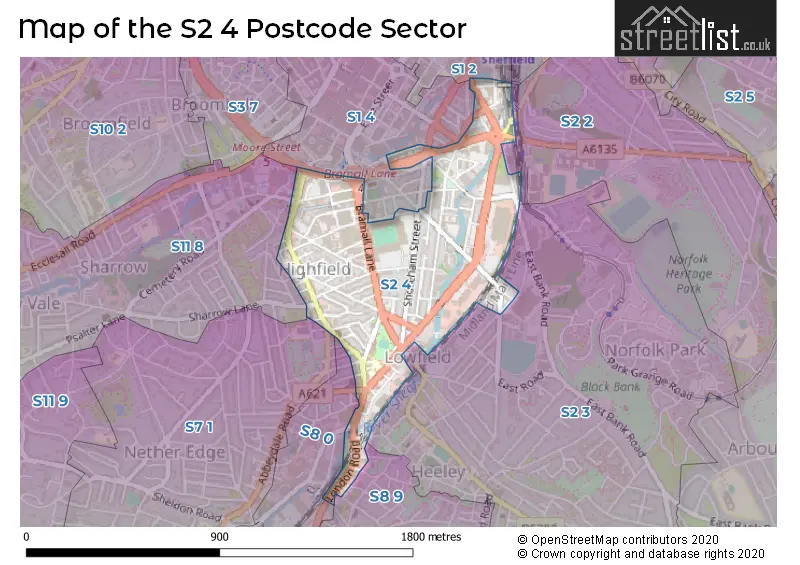
The S2 4 Postcode shares a border with S2 2 (SHEFFIELD), S2 3 (SHEFFIELD, Heeley), S2 5 (SHEFFIELD, Park Hill), S7 1 (SHEFFIELD), S11 8 (SHEFFIELD), S1 2 (SHEFFIELD), S1 4 (SHEFFIELD), S8 0 (SHEFFIELD) and S8 9 (SHEFFIELD).
The sector is within the post town of SHEFFIELD.
S2 4 is a postcode sector within the S2 postcode district which is within the S Sheffield postcode area.
The Royal Mail delivery office for the S2 4 postal sector is the Sheffield City 2 Delivery Office.
The area of the S2 4 postcode sector is 0.36 square miles which is 0.94 square kilometres or 231.23 square acres.
Waterways within the S2 4 postcode sector include the Porter Brook, River Sheaf.

Map of the S2 4 Postcode Sector
Explore the S2 4 postcode sector by using our free interactive map.
| S | 2 | - | 4 | X | X |
| S | 2 | Space | 4 | Letter | Letter |
Official List of Streets
SHEFFIELD (62 Streets)
Unofficial Streets or Alternative Spellings
SHEFFIELD
ABBEYDALE ROAD ALBERT ROAD ARTISAN VIEW BARON STREET BRITTAIN STREET BROADFIELD ROAD CLUB GARDEN WALK EAST BANK ROAD FARM ROAD FIELDHEAD ROAD GLEADLESS ROAD GLOVER ROAD GRANVILLE ROAD HEELEY BANK ROAD LEADMILL ROAD MARY STREET MATILDA STREET MOUNT PLEASANT ROAD MYRTLE ROAD NORFOLK PARK ROAD OAK STREET OLIVE GROVE ROAD PARK GRANGE ROAD SHARROW LANE SHEAF STREET SHREWSBURY ROAD SITWELL ROAD SOUTH LANE THIRLWELL ROAD WELL ROAD WITNEY STREET WOLSELEY ROAD ASCOT STREET ATKIN PLACE BRAMALL COURT BRAMALL LANE ROUNDABOUT BROOM CLOSE CHARLOTTE COURT CROSS WALK CUTLERS WALK (RIVER SHEAF WALK) GRANVILLE SQUARE HARRINGTON ROAD HEELEY BRIDGE HERMITAGE STREET JERSEY ROAD LANSDOWNE ROAD LOWFIELD COURT PORTER BROOK TRAIL RIVER SHEAF WALK RIVER SHEAF WALK (CLOSED SECTION) SAINT MARYS GATE SAINT MARYS ROAD SAINT WILFRIDS ROAD SARK ROAD SHELDON STREET SILVER MILL ROAD SITWELL PLACE SUFFOLK LANE TURNER STREET UNSTONE STREET WARD PLACEWeather Forecast for S2 4
Press Button to Show Forecast for Lowfield
| Time Period | Icon | Description | Temperature | Rain Probability | Wind |
|---|---|---|---|---|---|
| 03:00 to 06:00 | Partly cloudy (night) | 3.0°C (feels like 1.0°C) | 1.00% | N 4 mph | |
| 06:00 to 09:00 | Partly cloudy (day) | 3.0°C (feels like 1.0°C) | 1.00% | N 4 mph | |
| 09:00 to 12:00 | Cloudy | 6.0°C (feels like 5.0°C) | 4.00% | NE 7 mph | |
| 12:00 to 15:00 | Overcast | 9.0°C (feels like 8.0°C) | 9.00% | ENE 4 mph | |
| 15:00 to 18:00 | Cloudy | 9.0°C (feels like 8.0°C) | 6.00% | ENE 4 mph | |
| 18:00 to 21:00 | Cloudy | 7.0°C (feels like 5.0°C) | 10.00% | ENE 7 mph | |
| 21:00 to 00:00 | Cloudy | 5.0°C (feels like 3.0°C) | 8.00% | ENE 7 mph |
Press Button to Show Forecast for Lowfield
| Time Period | Icon | Description | Temperature | Rain Probability | Wind |
|---|---|---|---|---|---|
| 00:00 to 03:00 | Cloudy | 4.0°C (feels like 3.0°C) | 8.00% | NE 4 mph | |
| 03:00 to 06:00 | Cloudy | 4.0°C (feels like 1.0°C) | 9.00% | NE 4 mph | |
| 06:00 to 09:00 | Partly cloudy (day) | 4.0°C (feels like 1.0°C) | 8.00% | NE 7 mph | |
| 09:00 to 12:00 | Cloudy | 8.0°C (feels like 5.0°C) | 11.00% | ENE 9 mph | |
| 12:00 to 15:00 | Overcast | 9.0°C (feels like 7.0°C) | 20.00% | ENE 9 mph | |
| 15:00 to 18:00 | Overcast | 10.0°C (feels like 8.0°C) | 20.00% | ENE 9 mph | |
| 18:00 to 21:00 | Cloudy | 9.0°C (feels like 6.0°C) | 18.00% | ENE 11 mph | |
| 21:00 to 00:00 | Cloudy | 7.0°C (feels like 4.0°C) | 16.00% | NE 11 mph |
Press Button to Show Forecast for Lowfield
| Time Period | Icon | Description | Temperature | Rain Probability | Wind |
|---|---|---|---|---|---|
| 00:00 to 03:00 | Cloudy | 7.0°C (feels like 3.0°C) | 22.00% | NE 11 mph | |
| 03:00 to 06:00 | Light rain | 7.0°C (feels like 3.0°C) | 51.00% | NNE 13 mph | |
| 06:00 to 09:00 | Heavy rain | 7.0°C (feels like 3.0°C) | 77.00% | NNE 13 mph | |
| 09:00 to 12:00 | Heavy rain | 8.0°C (feels like 5.0°C) | 77.00% | NNE 13 mph | |
| 12:00 to 15:00 | Heavy rain | 10.0°C (feels like 7.0°C) | 78.00% | NNE 13 mph | |
| 15:00 to 18:00 | Light rain shower (day) | 10.0°C (feels like 7.0°C) | 42.00% | NNW 11 mph | |
| 18:00 to 21:00 | Overcast | 9.0°C (feels like 7.0°C) | 21.00% | NW 9 mph | |
| 21:00 to 00:00 | Partly cloudy (night) | 8.0°C (feels like 6.0°C) | 9.00% | SSE 7 mph |
Schools and Places of Education Within the S2 4 Postcode Sector
Lowfield Community Primary School
Community school
London Road, Sheffield, South Yorkshire, S2 4NJ
Head: Mr Christopher Holder
Ofsted Rating: Good
Inspection: 2022-06-22 (674 days ago)
Website: Visit Lowfield Community Primary School Website
Phone: 01142552501
Number of Pupils: 405
House Prices in the S2 4 Postcode Sector
| Type of Property | 2018 Average | 2018 Sales | 2017 Average | 2017 Sales | 2016 Average | 2016 Sales | 2015 Average | 2015 Sales |
|---|---|---|---|---|---|---|---|---|
| Detached | £150,000 | 1 | £245,000 | 1 | £0 | 0 | £0 | 0 |
| Semi-Detached | £142,500 | 4 | £122,000 | 1 | £0 | 0 | £124,000 | 1 |
| Terraced | £4,960,193 | 36 | £122,506 | 31 | £132,269 | 39 | £117,445 | 28 |
| Flats | £105,841 | 16 | £109,797 | 18 | £100,205 | 22 | £80,864 | 25 |
Important Postcodes S2 4 in the Postcode Sector
S2 4EA is the postcode for 7, Edmund Road
S2 4LA is the postcode for Business Enterprise & Regulatory Reform, St. Marys House, 11 London Road
S2 4NF is the postcode for Sheffield Libraries & Information Services, Highfield Branch Library, London Road
S2 4NJ is the postcode for Lowfield Primary School, London Road, BUILDING A, Lowfield Primary School, London Road, BUILDING C, Lowfield Primary School, London Road, and BUILDING B, Lowfield Primary School, London Road
S2 4UJ is the postcode for The My Place, U Mix Building, 17 Asline Road
| The S2 4 Sector is within these Local Authorities |
|
|---|---|
| The S2 4 Sector is within these Counties |
|
| The S2 4 Sector is within these Water Company Areas |
|