The S42 postcode district is a postal district located in the S Sheffield postcode area with a population of 29,814 residents according to the 2021 England and Wales Census.
The area of the S42 postcode district is 27.59 square miles which is 71.46 square kilometres or 17,658.50 acres.
Currently, the S42 district has about 772 postcode units spread across 3 geographic postcode sectors.
Given that each sector allows for 400 unique postcode combinations, the district has a capacity of 1,200 postcodes. With 772 postcodes already in use, this leaves 428 units available.
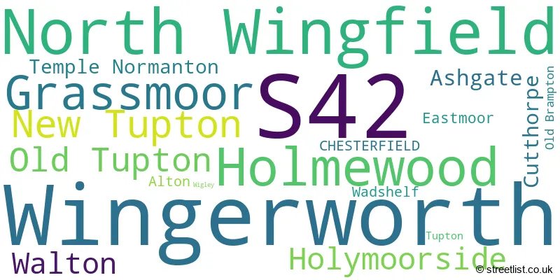
The largest settlement in the S42 postal code is Wingerworth followed by North Wingfield, and Holmewood.
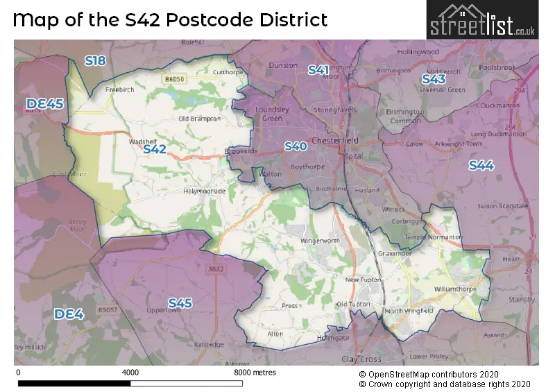
The S42 Postcode shares a border with DE45 (BAKEWELL, Youlgrave, Baslow), S40 (CHESTERFIELD), S41 (CHESTERFIELD, Hasland, Old Whittington), S44 (Bolsover, Calow, Duckmanton), S45 (Clay Cross, Pilsley, Danesmoor) and S18 (DRONFIELD, Dronfield Woodhouse, Coal Aston).
The primary settlement in the S42 postcode district is Chesterfield, located in the county of Derbyshire, England. Other significant settlements in the district include Grassmoor, Holmewood, North Wingfield, Temple Normanton, Alton, New Tupton, Old Tupton, Tupton, Wingerworth, Ashgate, Cutthorpe, Eastmoor, Holymoorside, Old Brampton, Wadshelf, Walton, and Wigley. The most significant post town in the district is Chesterfield.
For the district S42, we have data on 3 postcode sectors. Here's a breakdown: The sector S42 5, covers North Wingfield and Holmewood and Grassmoor in Derbyshire. The sector S42 6, covers Wingerworth and New Tupton and Old Tupton in Derbyshire. The sector S42 7, covers Holymoorside and Walton and Ashgate and Cutthorpe in Derbyshire.

Map of the S42 Postcode District
Explore the S42 postcode district by using our free interactive map.
When it comes to local government, postal geography often disregards political borders. However, for a breakdown in the S42 District: the district mostly encompasses the North East Derbyshire District (759 postcodes), and finally, the Chesterfield District (B) area (48 postcodes).
Recent House Sales in S42
| Date | Price | Address |
|---|---|---|
| 09/10/2023 | £125,000 | Oak Crescent, Wingerworth, Chesterfield, S42 6PY |
| 06/10/2023 | £240,000 | Mansfield Road, Temple Normanton, Chesterfield, S42 5DG |
| 27/09/2023 | £145,000 | Lathkill Court, North Wingfield, Chesterfield, S42 5UE |
| 21/09/2023 | £400,000 | Hayfield Close, Wingerworth, Chesterfield, S42 6QF |
| 15/09/2023 | £105,000 | Hunloke Road, Holmewood, Chesterfield, S42 5RY |
| 15/09/2023 | £165,000 | Nottingham Drive, Wingerworth, Chesterfield, S42 6WD |
| 15/09/2023 | £115,000 | Heath Road, Holmewood, Chesterfield, S42 5RA |
| 08/09/2023 | £148,500 | North Side, New Tupton, Chesterfield, S42 6BW |
| 08/09/2023 | £175,000 | Masefield Avenue, Holmewood, Chesterfield, S42 5TL |
| 08/09/2023 | £175,000 | Cornwall Drive, Grassmoor, Chesterfield, S42 5DX |
Weather Forecast for S42
Press Button to Show Forecast for Chatsworth House
| Time Period | Icon | Description | Temperature | Rain Probability | Wind |
|---|---|---|---|---|---|
| 06:00 to 09:00 | Partly cloudy (day) | 3.0°C (feels like 1.0°C) | 1.00% | N 4 mph | |
| 09:00 to 12:00 | Partly cloudy (day) | 6.0°C (feels like 5.0°C) | 3.00% | ENE 7 mph | |
| 12:00 to 15:00 | Overcast | 8.0°C (feels like 7.0°C) | 9.00% | ENE 4 mph | |
| 15:00 to 18:00 | Cloudy | 9.0°C (feels like 8.0°C) | 8.00% | ENE 4 mph | |
| 18:00 to 21:00 | Cloudy | 8.0°C (feels like 6.0°C) | 9.00% | E 7 mph | |
| 21:00 to 00:00 | Partly cloudy (night) | 5.0°C (feels like 3.0°C) | 8.00% | ENE 7 mph |
Press Button to Show Forecast for Chatsworth House
| Time Period | Icon | Description | Temperature | Rain Probability | Wind |
|---|---|---|---|---|---|
| 00:00 to 03:00 | Partly cloudy (night) | 4.0°C (feels like 2.0°C) | 7.00% | ENE 4 mph | |
| 03:00 to 06:00 | Cloudy | 3.0°C (feels like 1.0°C) | 12.00% | NE 4 mph | |
| 06:00 to 09:00 | Cloudy | 4.0°C (feels like 2.0°C) | 11.00% | NE 7 mph | |
| 09:00 to 12:00 | Cloudy | 7.0°C (feels like 5.0°C) | 13.00% | ENE 9 mph | |
| 12:00 to 15:00 | Cloudy | 9.0°C (feels like 6.0°C) | 18.00% | ENE 9 mph | |
| 15:00 to 18:00 | Overcast | 10.0°C (feels like 7.0°C) | 23.00% | ENE 9 mph | |
| 18:00 to 21:00 | Cloudy | 9.0°C (feels like 6.0°C) | 20.00% | ENE 9 mph | |
| 21:00 to 00:00 | Cloudy | 7.0°C (feels like 5.0°C) | 18.00% | NE 9 mph |
Press Button to Show Forecast for Chatsworth House
| Time Period | Icon | Description | Temperature | Rain Probability | Wind |
|---|---|---|---|---|---|
| 00:00 to 03:00 | Cloudy | 7.0°C (feels like 4.0°C) | 22.00% | NE 9 mph | |
| 03:00 to 06:00 | Light rain | 6.0°C (feels like 4.0°C) | 49.00% | NE 9 mph | |
| 06:00 to 09:00 | Light rain | 7.0°C (feels like 4.0°C) | 53.00% | NNE 9 mph | |
| 09:00 to 12:00 | Heavy rain | 9.0°C (feels like 6.0°C) | 76.00% | NNE 11 mph | |
| 12:00 to 15:00 | Heavy rain | 10.0°C (feels like 8.0°C) | 76.00% | NNE 11 mph | |
| 15:00 to 18:00 | Light rain | 11.0°C (feels like 8.0°C) | 52.00% | NNE 11 mph | |
| 18:00 to 21:00 | Heavy rain shower (day) | 10.0°C (feels like 8.0°C) | 54.00% | NE 9 mph | |
| 21:00 to 00:00 | Cloudy | 8.0°C (feels like 6.0°C) | 13.00% | E 7 mph |
Where is the S42 Postcode District?
The S42 postcode district is located in Chesterfield. Chesterfield is surrounded by several nearby towns: to the north is Dronfield, which is approximately 6 miles away, to the southwest is Matlock, approximately 7 miles away, to the south is Alfreton, approximately 9 miles away, to the west is Bakewell, approximately 9 miles away, and to the southeast is Sutton-in-Ashfield, approximately 10 miles away. Chesterfield is also located approximately 131 miles north of London.
The district is within the post town of CHESTERFIELD.
The sector has postcodes within the nation of England.
The S42 Postcode District is covers the following regions.
- East Derbyshire - Derbyshire and Nottinghamshire - East Midlands (England)
- South and West Derbyshire - Derbyshire and Nottinghamshire - East Midlands (England)
| Postcode Sector | Delivery Office |
|---|---|
| S42 5 | Chesterfield Delivery Office |
| S42 6 | Chesterfield Delivery Office |
| S42 7 | Chesterfield Delivery Office |
| S | 4 | 2 | - | X | X | X |
| S | 4 | 2 | Space | Numeric | Letter | Letter |
Current Monthly Rental Prices
| # Bedrooms | Min Price | Max Price | Avg Price |
|---|---|---|---|
| 2 | £675 | £1,500 | £938 |
| 3 | £750 | £1,000 | £935 |
| 4 | £1,400 | £1,400 | £1,400 |
Current House Prices
| # Bedrooms | Min Price | Max Price | Avg Price |
|---|---|---|---|
| £25,000 | £650,000 | £306,250 | |
| 2 | £38,750 | £345,000 | £172,990 |
| 3 | £110,000 | £599,950 | £257,988 |
| 4 | £189,950 | £2,000,000 | £435,693 |
| 5 | £319,995 | £1,200,000 | £557,911 |
| 6 | £675,000 | £1,400,000 | £974,983 |
Estate Agents who Operate in the S42 District
| Logo | Name | Brand Name | Address | Contact Number | Total Properties |
|---|---|---|---|---|---|
 | Chesterfield | Redbrik | 13-15 Glumangate, Chesterfield, S40 1TX | 01246 383327 | 25 |
 | Chesterfield | Hunters | Unit 4, The Glass Yard, Sheffield Road, Chesterfield S41 8JY | 01246 383383 | 19 |
 | Chesterfield | Wilkins Vardy Residential | 23 Glumangate Chesterfield Derbyshire, S40 1TX | 01246 383354 | 17 |
 | covering Sheffield | Purplebricks | Suite 7 First Floor Cranmore Drive Shirley Solihull B90 4RZ | 020 3834 8396 | 14 |
 | Chesterfield | Dales & Peaks | 131 Chatsworth Road Chesterfield S40 2AP | 01246 383317 | 13 |
| Type of Property | 2018 Average | 2018 Sales | 2017 Average | 2017 Sales | 2016 Average | 2016 Sales | 2015 Average | 2015 Sales |
|---|---|---|---|---|---|---|---|---|
| Detached | £275,026 | 304 | £263,492 | 263 | £246,593 | 264 | £260,367 | 259 |
| Semi-Detached | £138,846 | 216 | £138,018 | 169 | £133,268 | 190 | £130,227 | 160 |
| Terraced | £127,828 | 88 | £121,498 | 73 | £103,983 | 61 | £107,708 | 82 |
| Flats | £128,800 | 5 | £155,688 | 8 | £160,750 | 4 | £190,833 | 3 |