The S42 6 postcode sector is within the county of Derbyshire.
Did you know? According to the 2021 Census, the S42 6 postcode sector is home to a bustling 11,979 residents!
Given that each sector allows for 400 unique postcode combinations. Letters C, I, K, M, O and V are not allowed in the last two letters of a postcode. With 315 postcodes already in use, this leaves 85 units available.
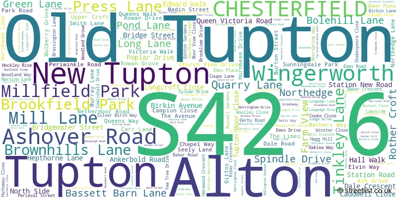
The largest settlement in the S42 6 postal code is Wingerworth followed by New Tupton, and Old Tupton.
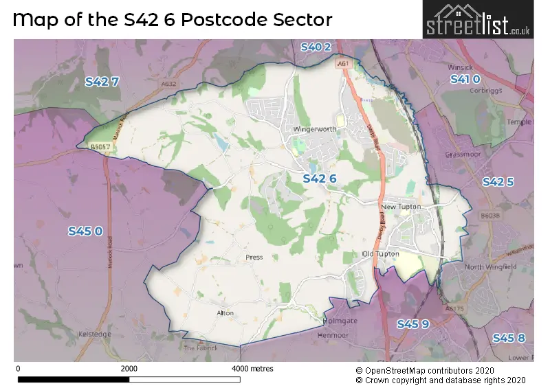
The S42 6 Postcode shares a border with S45 0 (Ashover), S45 9 (Clay Cross, Danesmoor), S40 2 (CHESTERFIELD), S41 0 (CHESTERFIELD, Hasland), S42 5 (North Wingfield, Holmewood, Grassmoor) and S42 7 (Holymoorside, Walton, Ashgate).
The sector is within the post town of CHESTERFIELD.
S42 6 is a postcode sector within the S42 postcode district which is within the S Sheffield postcode area.
The Royal Mail delivery office for the S42 6 postal sector is the Chesterfield Delivery Office.
The area of the S42 6 postcode sector is 8.43 square miles which is 21.84 square kilometres or 5,396.91 square acres.
Waterways within the S42 6 postcode sector include the River Rother.

Map of the S42 6 Postcode Sector
Explore the S42 6 postcode sector by using our free interactive map.
| S | 4 | 2 | - | 6 | X | X |
| S | 4 | 2 | Space | 6 | Letter | Letter |
Official List of Streets
Wingerworth (123 Streets)
Old Tupton (34 Streets)
New Tupton (38 Streets)
Alton (5 Streets)
Tupton (3 Streets)
Unofficial Streets or Alternative Spellings
Clay Cross
COUPE LANE DERBY ROAD ALTON HILL BOTTOM ROAD CHAPEL WALK CROSS ROAD GRINDERSWELL LANE HILLHOUSE COURT IVANHOE CLOSE JOHN STREET LAKE LANDS MICHAELS CLOSE MIDDLE ROAD NEW STREET PACKMAN COTTAGES PEARTREE AVENUE STEEP LANE STOCKMOOR LANE STONEYCROFT LANE TOP ROAD WILLOW SQUARE WOODLANDS GROVE WOODLANDS WAYGrassmoor
MILL LANEWalton
HIGH LANE SLATE PIT DALENorth Wingfield
STATION ROADAshover
ALTON LANE ASHOVER ROAD BIRKIN LANE DARLEY ROAD MATLOCK ROADWeather Forecast for S42 6
Press Button to Show Forecast for Clay Cross
| Time Period | Icon | Description | Temperature | Rain Probability | Wind |
|---|---|---|---|---|---|
| 03:00 to 06:00 | Clear night | 1.0°C (feels like -1.0°C) | 1.00% | N 4 mph | |
| 06:00 to 09:00 | Sunny day | 2.0°C (feels like 0.0°C) | 1.00% | N 4 mph | |
| 09:00 to 12:00 | Cloudy | 6.0°C (feels like 4.0°C) | 5.00% | ENE 7 mph | |
| 12:00 to 15:00 | Overcast | 8.0°C (feels like 7.0°C) | 9.00% | ENE 4 mph | |
| 15:00 to 18:00 | Cloudy | 9.0°C (feels like 8.0°C) | 7.00% | E 4 mph | |
| 18:00 to 21:00 | Cloudy | 7.0°C (feels like 5.0°C) | 12.00% | ENE 7 mph | |
| 21:00 to 00:00 | Partly cloudy (night) | 4.0°C (feels like 3.0°C) | 7.00% | ENE 4 mph |
Press Button to Show Forecast for Clay Cross
| Time Period | Icon | Description | Temperature | Rain Probability | Wind |
|---|---|---|---|---|---|
| 00:00 to 03:00 | Cloudy | 3.0°C (feels like 1.0°C) | 9.00% | NNE 4 mph | |
| 03:00 to 06:00 | Cloudy | 2.0°C (feels like 0.0°C) | 12.00% | NNE 4 mph | |
| 06:00 to 09:00 | Cloudy | 4.0°C (feels like 1.0°C) | 11.00% | NNE 7 mph | |
| 09:00 to 12:00 | Cloudy | 7.0°C (feels like 4.0°C) | 12.00% | ENE 9 mph | |
| 12:00 to 15:00 | Overcast | 9.0°C (feels like 7.0°C) | 19.00% | ENE 9 mph | |
| 15:00 to 18:00 | Cloudy | 10.0°C (feels like 7.0°C) | 21.00% | ENE 9 mph | |
| 18:00 to 21:00 | Cloudy | 9.0°C (feels like 6.0°C) | 18.00% | ENE 9 mph | |
| 21:00 to 00:00 | Cloudy | 6.0°C (feels like 3.0°C) | 16.00% | NE 9 mph |
Press Button to Show Forecast for Clay Cross
| Time Period | Icon | Description | Temperature | Rain Probability | Wind |
|---|---|---|---|---|---|
| 00:00 to 03:00 | Cloudy | 6.0°C (feels like 2.0°C) | 19.00% | NE 11 mph | |
| 03:00 to 06:00 | Light rain | 6.0°C (feels like 2.0°C) | 51.00% | NNE 11 mph | |
| 06:00 to 09:00 | Heavy rain | 6.0°C (feels like 3.0°C) | 76.00% | NNE 13 mph | |
| 09:00 to 12:00 | Heavy rain | 7.0°C (feels like 4.0°C) | 78.00% | NNE 13 mph | |
| 12:00 to 15:00 | Heavy rain | 9.0°C (feels like 6.0°C) | 74.00% | NNE 13 mph | |
| 15:00 to 18:00 | Light rain | 9.0°C (feels like 6.0°C) | 53.00% | NNE 11 mph | |
| 18:00 to 21:00 | Cloudy | 9.0°C (feels like 7.0°C) | 15.00% | NNE 9 mph | |
| 21:00 to 00:00 | Partly cloudy (night) | 6.0°C (feels like 5.0°C) | 9.00% | SSE 7 mph |
Schools and Places of Education Within the S42 6 Postcode Sector
Deer Park Primary School
Community school
New Road, Chesterfield, Derbyshire, S42 6TD
Head: Mrs Annette Lupton
Ofsted Rating: Good
Inspection: 2023-03-08 (415 days ago)
Website: Visit Deer Park Primary School Website
Phone: 01246232696
Number of Pupils: 345
Hunloke Park Primary School
Community school
Hunloke Park Primary School, Lodge Drive, Chesterfield, Derbyshire, S42 6PT
Head: Mrs Jennifer Murphy
Ofsted Rating: Good
Inspection: 2018-09-19 (2046 days ago)
Website: Visit Hunloke Park Primary School Website
Phone: 01246276831
Number of Pupils: 276
Tupton Hall School
Academy sponsor led
Station New Road, Chesterfield, , S42 6LG
Head: Mr Andrew Knowles
Ofsted Rating: Good
Inspection: 2022-12-01 (512 days ago)
Website: Visit Tupton Hall School Website
Phone: 01246863127
Number of Pupils: 1574
Tupton Primary and Nursery Academy
Academy sponsor led
Queen Victoria Road, Chesterfield, Derbyshire, S42 6DY
Head: Miss Katherine Richards
Ofsted Rating: Good
Inspection: 2023-10-19 (190 days ago)
Website: Visit Tupton Primary and Nursery Academy Website
Phone: 01246862191
Number of Pupils: 238
House Prices in the S42 6 Postcode Sector
| Type of Property | 2018 Average | 2018 Sales | 2017 Average | 2017 Sales | 2016 Average | 2016 Sales | 2015 Average | 2015 Sales |
|---|---|---|---|---|---|---|---|---|
| Detached | £280,783 | 145 | £263,682 | 126 | £261,991 | 122 | £255,303 | 165 |
| Semi-Detached | £159,512 | 81 | £161,437 | 66 | £154,562 | 77 | £138,090 | 78 |
| Terraced | £175,591 | 21 | £151,426 | 14 | £158,449 | 10 | £186,650 | 13 |
| Flats | £0 | 0 | £0 | 0 | £0 | 0 | £90,000 | 1 |
Important Postcodes S42 6 in the Postcode Sector
S42 6DY is the postcode for MAIN BUILDING, Tupton Primary School, Queen Victoria Road
S42 6LG is the postcode for Main Building, Tupton Hall School, Old Tupton, and Tupton Hall School, Old Tupton
S42 6NG is the postcode for Council Offices, Mill Lane, and NEDDC COUNCIL OFFICES, MILL LANE, WINGERWORTH
S42 6NT is the postcode for Pioneer House, Mill Lane, and Pioneer House, Mill Lane, Wingerworth
S42 6PT is the postcode for Hunloke Park Primary School, Lodge Drive
S42 6TD is the postcode for DEER PARK PRIMARY SCHOOL, NEW ROAD, WINGERWORTH, and Deer Park Primary School, New Road
| The S42 6 Sector is within these Local Authorities |
|
|---|---|
| The S42 6 Sector is within these Counties |
|
| The S42 6 Sector is within these Water Company Areas |
|