The S41 postcode district is a postal district located in the S Sheffield postcode area with a population of 36,906 residents according to the 2021 England and Wales Census.
The area of the S41 postcode district is 9.29 square miles which is 24.05 square kilometres or 5,943.26 acres.
Currently, the S41 district has about 979 postcode units spread across 4 geographic postcode sectors.
Given that each sector allows for 400 unique postcode combinations, the district has a capacity of 1,600 postcodes. With 979 postcodes already in use, this leaves 621 units available.
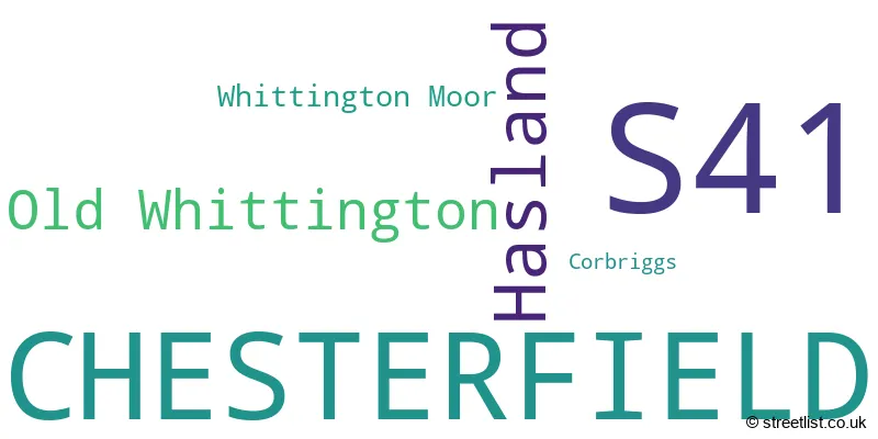
The largest settlement in the S41 postal code is CHESTERFIELD followed by Hasland, and Old Whittington.
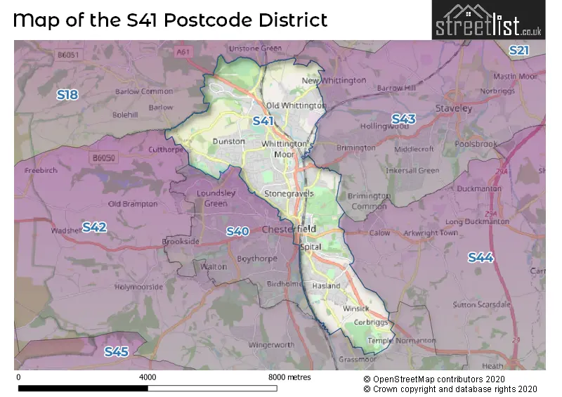
The S41 Postcode shares a border with S40 (CHESTERFIELD), S42 (Wingerworth, North Wingfield, Holmewood), S43 (Brimington, Clowne, Staveley), S44 (Bolsover, Calow, Duckmanton) and S18 (DRONFIELD, Dronfield Woodhouse, Coal Aston).
The primary settlement in the S41 postcode district is Chesterfield, located in the county of Derbyshire in England. Other significant settlements in the district include Corbriggs, Hasland, Whittington Moor, and Old Whittington. The most significant Postal Town in the district is Chesterfield.
For the district S41, we have data on 4 postcode sectors. Here's a breakdown: The sector S41 0, covers Chesterfield and Hasland in Derbyshire. The sector S41 7, covers Chesterfield in Derbyshire. The sector S41 8, covers Chesterfield in Derbyshire. The sector S41 9, covers Old Whittington and Chesterfield in Derbyshire.

Map of the S41 Postcode District
Explore the S41 postcode district by using our free interactive map.
When it comes to local government, postal geography often disregards political borders. However, for a breakdown in the S41 District: the district mostly encompasses the Chesterfield District (B) (976 postcodes), and finally, the North East Derbyshire District area (28 postcodes).
Recent House Sales in S41
| Date | Price | Address |
|---|---|---|
| 13/10/2023 | £370,000 | Whinfell Road, Chesterfield, S41 8ES |
| 12/10/2023 | £131,000 | Higher Albert Street, Chesterfield, S41 7QE |
| 06/10/2023 | £430,000 | Bank Wood Close, Chesterfield, S41 8XQ |
| 06/10/2023 | £119,000 | St Johns Road, Chesterfield, S41 8PU |
| 29/09/2023 | £151,000 | Rempstone Drive, Chesterfield, S41 0XQ |
| 29/09/2023 | £134,000 | Camlough Walk, Chesterfield, S41 0FS |
| 22/09/2023 | £230,000 | Eastwood Close, Hasland, Chesterfield, S41 0BE |
| 22/09/2023 | £171,500 | Devonshire Avenue East, Hasland, Chesterfield, S41 0AE |
| 14/09/2023 | £112,000 | Sanforth Street, Chesterfield, S41 8RS |
| 13/09/2023 | £170,000 | Blandford Drive, Chesterfield, S41 8QT |
Weather Forecast for S41
Press Button to Show Forecast for Chesterfield
| Time Period | Icon | Description | Temperature | Rain Probability | Wind |
|---|---|---|---|---|---|
| 09:00 to 12:00 | Cloudy | 8.0°C (feels like 5.0°C) | 10.00% | NE 9 mph | |
| 12:00 to 15:00 | Overcast | 9.0°C (feels like 7.0°C) | 23.00% | ENE 9 mph | |
| 15:00 to 18:00 | Overcast | 9.0°C (feels like 7.0°C) | 22.00% | ENE 9 mph | |
| 18:00 to 21:00 | Overcast | 8.0°C (feels like 5.0°C) | 12.00% | ENE 11 mph | |
| 21:00 to 00:00 | Overcast | 7.0°C (feels like 4.0°C) | 10.00% | NE 9 mph |
Press Button to Show Forecast for Chesterfield
| Time Period | Icon | Description | Temperature | Rain Probability | Wind |
|---|---|---|---|---|---|
| 00:00 to 03:00 | Overcast | 6.0°C (feels like 3.0°C) | 10.00% | NNE 11 mph | |
| 03:00 to 06:00 | Light rain | 6.0°C (feels like 2.0°C) | 55.00% | N 11 mph | |
| 06:00 to 09:00 | Heavy rain | 6.0°C (feels like 2.0°C) | 82.00% | N 13 mph | |
| 09:00 to 12:00 | Heavy rain | 6.0°C (feels like 3.0°C) | 83.00% | NNW 13 mph | |
| 12:00 to 15:00 | Light rain | 8.0°C (feels like 5.0°C) | 49.00% | NW 11 mph | |
| 15:00 to 18:00 | Overcast | 10.0°C (feels like 7.0°C) | 16.00% | WNW 9 mph | |
| 18:00 to 21:00 | Partly cloudy (day) | 10.0°C (feels like 8.0°C) | 6.00% | W 9 mph | |
| 21:00 to 00:00 | Clear night | 7.0°C (feels like 5.0°C) | 3.00% | WSW 7 mph |
Press Button to Show Forecast for Chesterfield
| Time Period | Icon | Description | Temperature | Rain Probability | Wind |
|---|---|---|---|---|---|
| 00:00 to 03:00 | Clear night | 5.0°C (feels like 3.0°C) | 1.00% | SW 7 mph | |
| 03:00 to 06:00 | Clear night | 4.0°C (feels like 2.0°C) | 0.00% | SSW 4 mph | |
| 06:00 to 09:00 | Sunny day | 5.0°C (feels like 3.0°C) | 1.00% | SSW 7 mph | |
| 09:00 to 12:00 | Sunny day | 10.0°C (feels like 8.0°C) | 1.00% | S 11 mph | |
| 12:00 to 15:00 | Overcast | 13.0°C (feels like 11.0°C) | 8.00% | S 13 mph | |
| 15:00 to 18:00 | Cloudy | 14.0°C (feels like 11.0°C) | 6.00% | S 13 mph | |
| 18:00 to 21:00 | Partly cloudy (day) | 13.0°C (feels like 11.0°C) | 3.00% | S 11 mph | |
| 21:00 to 00:00 | Clear night | 10.0°C (feels like 8.0°C) | 2.00% | SSE 9 mph |
Press Button to Show Forecast for Chesterfield
| Time Period | Icon | Description | Temperature | Rain Probability | Wind |
|---|---|---|---|---|---|
| 00:00 to 03:00 | Clear night | 8.0°C (feels like 6.0°C) | 2.00% | SSE 7 mph | |
| 03:00 to 06:00 | Clear night | 7.0°C (feels like 5.0°C) | 2.00% | ESE 7 mph | |
| 06:00 to 09:00 | Sunny day | 7.0°C (feels like 6.0°C) | 3.00% | ESE 7 mph | |
| 09:00 to 12:00 | Partly cloudy (day) | 12.0°C (feels like 10.0°C) | 5.00% | ESE 9 mph | |
| 12:00 to 15:00 | Partly cloudy (day) | 15.0°C (feels like 13.0°C) | 5.00% | ESE 11 mph | |
| 15:00 to 18:00 | Cloudy | 16.0°C (feels like 14.0°C) | 10.00% | ESE 11 mph | |
| 18:00 to 21:00 | Cloudy | 15.0°C (feels like 13.0°C) | 8.00% | ESE 9 mph | |
| 21:00 to 00:00 | Cloudy | 12.0°C (feels like 10.0°C) | 9.00% | E 7 mph |
Where is the S41 Postcode District?
The S41 postcode district is located in Chesterfield, which is a town in Derbyshire. Chesterfield is surrounded by several nearby towns: Dronfield to the northwest, Sheffield to the north, Matlock to the southwest, Sutton-in-Ashfield to the southeast, Alfreton to the south, Bakewell to the west, and Worksop to the east. The distance between Chesterfield and the center of London is approximately 132.3 miles.
The district is within the post town of CHESTERFIELD.
The sector has postcodes within the nation of England.
The S41 Postcode District is in the East Derbyshire region of Derbyshire and Nottinghamshire within the East Midlands (England).
| Postcode Sector | Delivery Office |
|---|---|
| S41 0 | Chesterfield Delivery Office |
| S41 7 | Chesterfield Delivery Office |
| S41 8 | Chesterfield Delivery Office |
| S41 9 | Chesterfield Delivery Office |
| S | 4 | 1 | - | X | X | X |
| S | 4 | 1 | Space | Numeric | Letter | Letter |
Tourist Attractions within the Postcode Area
We found 3 visitor attractions within the S41 postcode area
| Revolution House |
|---|
| Historic Properties |
| Historic House / House and Garden / Palace |
| View Revolution House on Google Maps |
| Chesterfield Museum and Art Gallery |
| Museums & Art Galleries |
| Museum and / or Art Gallery |
| View Chesterfield Museum and Art Gallery on Google Maps |
| Tapton Lock Visitor Centre |
| Visitor Centres |
| Heritage / Visitor Centre |
| View Tapton Lock Visitor Centre on Google Maps |
Current Monthly Rental Prices
| # Bedrooms | Min Price | Max Price | Avg Price |
|---|---|---|---|
| 1 | £575 | £676 | £609 |
| 2 | £575 | £850 | £734 |
| 3 | £750 | £995 | £884 |
| 4 | £1,500 | £1,600 | £1,550 |
Current House Prices
| # Bedrooms | Min Price | Max Price | Avg Price |
|---|---|---|---|
| £5,000 | £695,000 | £350,000 | |
| 1 | £79,950 | £150,000 | £104,989 |
| 2 | £64,950 | £365,000 | £164,002 |
| 3 | £45,000 | £850,000 | £257,298 |
| 4 | £180,000 | £475,000 | £329,659 |
| 5 | £275,000 | £625,000 | £512,143 |
| 6 | £185,000 | £185,000 | £185,000 |
Estate Agents who Operate in the S41 District
| Logo | Name | Brand Name | Address | Contact Number | Total Properties |
|---|---|---|---|---|---|
 | Chesterfield | Wilkins Vardy Residential | 23 Glumangate Chesterfield Derbyshire, S40 1TX | 01246 383354 | 34 |
 | Chesterfield | Redbrik | 13-15 Glumangate, Chesterfield, S40 1TX | 01246 383327 | 28 |
 | Chesterfield | Hunters | Unit 4, The Glass Yard, Sheffield Road, Chesterfield S41 8JY | 01246 383383 | 26 |
 | Chesterfield | Wards Estate Agents | 17 Glumangate, Chesterfield, S40 1TX | 01246 383321 | 22 |
 | Chesterfield | Frank Innes | 10 Glumangate Chesterfield S40 1TP | 01246 383239 | 11 |
| Type of Property | 2018 Average | 2018 Sales | 2017 Average | 2017 Sales | 2016 Average | 2016 Sales | 2015 Average | 2015 Sales |
|---|---|---|---|---|---|---|---|---|
| Detached | £276,054 | 175 | £263,735 | 200 | £237,753 | 141 | £222,609 | 175 |
| Semi-Detached | £147,449 | 246 | £141,333 | 279 | £133,184 | 249 | £128,995 | 241 |
| Terraced | £122,924 | 160 | £111,808 | 139 | £117,357 | 169 | £103,212 | 154 |
| Flats | £110,978 | 37 | £101,346 | 25 | £104,375 | 24 | £103,435 | 31 |