The S25 postcode district is a postal district located in the S Sheffield postcode area with a population of 21,337 residents according to the 2021 England and Wales Census.
The area of the S25 postcode district is 10.13 square miles which is 26.23 square kilometres or 6,481.00 acres.
Currently, the S25 district has about 470 postcode units spread across 5 geographic postcode sectors.
Given that each sector allows for 400 unique postcode combinations, the district has a capacity of 2,000 postcodes. With 470 postcodes already in use, this leaves 1530 units available.
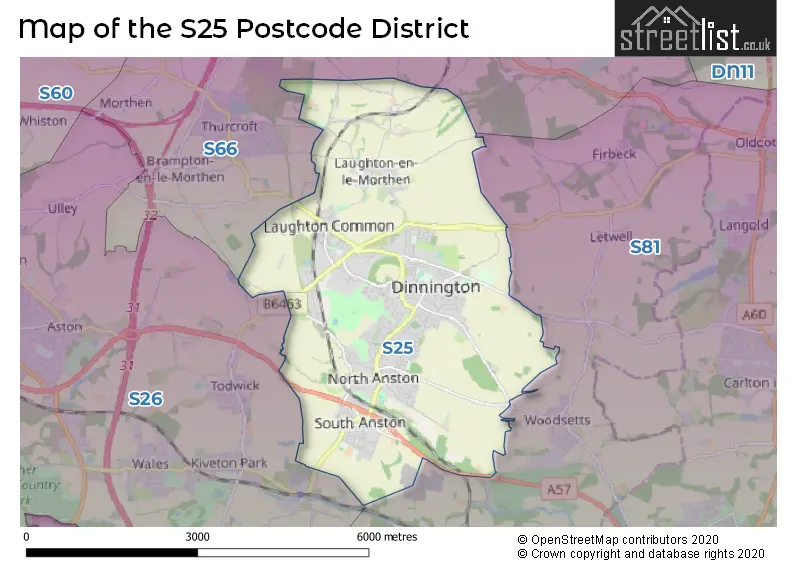
The largest settlement in the S25 postal code is Dinnington followed by North Anston, and South Anston.
The S25 Postcode shares a border with S26 (Swallownest, Aston, Kiveton Park), S81 (WORKSOP, Carlton-in-Lindrick, Langold) and S66 (Maltby, Wickersley, Bramley).
In the S25 postcode district, the primary settlement is Dinnington, located in the county of South Yorkshire in England. The most significant post town in this district is Sheffield. Other significant settlements include Laughton, Anston, North Anston, and South Anston.
For the district S25, we have data on 6 postcode sectors. Here's a breakdown: The sector S25 1, covers Laughton in South Yorkshire. The sector S25 2, covers Dinnington in South Yorkshire. The sector S25 3, covers Dinnington in South Yorkshire. The sector S25 4, covers North Anston in South Yorkshire. The sector S25 5, covers South Anston in South Yorkshire. The sector S25 9 is non-geographic. It's often designated for PO Boxes, large organisations, or special services.


Map of the S25 Postcode District
Explore the S25 postcode district by using our free interactive map.
When it comes to local government, postal geography often disregards political borders. However, for a breakdown in the S25 District: the district mostly encompasses the Rotherham District (B) area with a total of 490 postcodes.
Recent House Sales in S25
| Date | Price | Address |
|---|---|---|
| 20/10/2023 | £203,000 | St Leger Way, Dinnington, Sheffield, S25 2UU |
| 02/10/2023 | £390,000 | High Ash Drive, South Anston, Sheffield, S25 5HJ |
| 29/09/2023 | £202,500 | Knavesmire Avenue, Dinnington, Sheffield, S25 3RP |
| 29/09/2023 | £142,500 | Hunters Way, Dinnington, Sheffield, S25 2TH |
| 13/09/2023 | £380,000 | Main Street, North Anston, Sheffield, S25 4BD |
| 13/09/2023 | £83,000 | Lordens Hill, Dinnington, Sheffield, S25 2QG |
| 08/09/2023 | £168,000 | Park Lane, Laughton Common, Sheffield, S25 3UG |
| 06/09/2023 | £224,000 | Borrowdale Crescent, Dinnington, Sheffield, S25 2TW |
| 31/08/2023 | £198,000 | Ascot Drive, Laughton Common, Sheffield, S25 3AL |
| 31/08/2023 | £185,000 | Sanctuary Fields, North Anston, Sheffield, S25 4DD |
Weather Forecast for S25
Press Button to Show Forecast for Gildingwells
| Time Period | Icon | Description | Temperature | Rain Probability | Wind |
|---|---|---|---|---|---|
| 12:00 to 15:00 | Overcast | 9.0°C (feels like 6.0°C) | 20.00% | ENE 11 mph | |
| 15:00 to 18:00 | Overcast | 9.0°C (feels like 6.0°C) | 20.00% | ENE 11 mph | |
| 18:00 to 21:00 | Cloudy | 8.0°C (feels like 5.0°C) | 13.00% | NE 11 mph | |
| 21:00 to 00:00 | Cloudy | 6.0°C (feels like 4.0°C) | 8.00% | NE 9 mph |
Press Button to Show Forecast for Gildingwells
| Time Period | Icon | Description | Temperature | Rain Probability | Wind |
|---|---|---|---|---|---|
| 00:00 to 03:00 | Cloudy | 6.0°C (feels like 3.0°C) | 13.00% | NNE 9 mph | |
| 03:00 to 06:00 | Light rain | 6.0°C (feels like 2.0°C) | 53.00% | N 11 mph | |
| 06:00 to 09:00 | Light rain | 6.0°C (feels like 2.0°C) | 56.00% | N 13 mph | |
| 09:00 to 12:00 | Heavy rain | 7.0°C (feels like 3.0°C) | 77.00% | NNW 11 mph | |
| 12:00 to 15:00 | Heavy rain | 8.0°C (feels like 5.0°C) | 72.00% | NW 11 mph | |
| 15:00 to 18:00 | Overcast | 10.0°C (feels like 8.0°C) | 18.00% | WNW 9 mph | |
| 18:00 to 21:00 | Cloudy | 10.0°C (feels like 8.0°C) | 8.00% | W 9 mph | |
| 21:00 to 00:00 | Clear night | 7.0°C (feels like 5.0°C) | 2.00% | WSW 7 mph |
Press Button to Show Forecast for Gildingwells
| Time Period | Icon | Description | Temperature | Rain Probability | Wind |
|---|---|---|---|---|---|
| 00:00 to 03:00 | Clear night | 6.0°C (feels like 4.0°C) | 1.00% | SW 7 mph | |
| 03:00 to 06:00 | Clear night | 5.0°C (feels like 2.0°C) | 0.00% | SSW 7 mph | |
| 06:00 to 09:00 | Sunny day | 6.0°C (feels like 3.0°C) | 1.00% | S 7 mph | |
| 09:00 to 12:00 | Sunny day | 10.0°C (feels like 8.0°C) | 1.00% | S 11 mph | |
| 12:00 to 15:00 | Partly cloudy (day) | 13.0°C (feels like 11.0°C) | 2.00% | S 13 mph | |
| 15:00 to 18:00 | Cloudy | 14.0°C (feels like 11.0°C) | 6.00% | S 13 mph | |
| 18:00 to 21:00 | Partly cloudy (day) | 13.0°C (feels like 11.0°C) | 3.00% | SSE 11 mph | |
| 21:00 to 00:00 | Clear night | 11.0°C (feels like 9.0°C) | 2.00% | SSE 9 mph |
Press Button to Show Forecast for Gildingwells
| Time Period | Icon | Description | Temperature | Rain Probability | Wind |
|---|---|---|---|---|---|
| 00:00 to 03:00 | Clear night | 9.0°C (feels like 6.0°C) | 2.00% | SSE 9 mph | |
| 03:00 to 06:00 | Clear night | 7.0°C (feels like 5.0°C) | 2.00% | SE 7 mph | |
| 06:00 to 09:00 | Partly cloudy (day) | 8.0°C (feels like 6.0°C) | 4.00% | ESE 7 mph | |
| 09:00 to 12:00 | Partly cloudy (day) | 12.0°C (feels like 10.0°C) | 6.00% | ESE 9 mph | |
| 12:00 to 15:00 | Partly cloudy (day) | 15.0°C (feels like 13.0°C) | 9.00% | ESE 11 mph | |
| 15:00 to 18:00 | Cloudy | 16.0°C (feels like 13.0°C) | 14.00% | ESE 11 mph | |
| 18:00 to 21:00 | Partly cloudy (day) | 14.0°C (feels like 13.0°C) | 10.00% | ESE 9 mph | |
| 21:00 to 00:00 | Cloudy | 12.0°C (feels like 10.0°C) | 11.00% | E 7 mph |
Where is the S25 Postcode District?
The postcode district S25 is located in Sheffield, which is a district town. It is in close proximity to several nearby towns: Rotherham to the North West (6.24 miles away), Worksop to the South East (6.42 miles away), Mexborough to the North (9.25 miles away), Dronfield to the South West (11.61 miles away), Retford to the East (12.85 miles away), and Mansfield to the South (15.99 miles away). Additionally, the distance from S25 to the centre of London is approximately 136.59 miles.
The district is within the post town of SHEFFIELD.
The sector has postcodes within the nation of England.
The S25 Postcode District is in the Barnsley, Doncaster and Rotherham region of South Yorkshire within the Yorkshire and The Humber.
| Postcode Sector | Delivery Office |
|---|---|
| S25 1 | Dinnington Delivery Office |
| S25 2 | Dinnington Delivery Office |
| S25 3 | Dinnington Delivery Office |
| S25 4 | Dinnington Delivery Office |
| S25 5 | Dinnington Delivery Office |
| S | 2 | 5 | - | X | X | X |
| S | 2 | 5 | Space | Numeric | Letter | Letter |
Tourist Attractions within the Postcode Area
We found 1 visitor attractions within the S25 postcode area
| Tropical Butterfly House |
|---|
| Wildlife |
| Safari Park / Zoo / Aquarium / Aviary |
| View Tropical Butterfly House on Google Maps |
Current Monthly Rental Prices
| # Bedrooms | Min Price | Max Price | Avg Price |
|---|---|---|---|
| 1 | £575 | £575 | £575 |
| 2 | £625 | £850 | £723 |
| 3 | £700 | £1,100 | £849 |
| 4 | £1,895 | £1,895 | £1,895 |
| 5 | £1,650 | £1,650 | £1,650 |
Current House Prices
| # Bedrooms | Min Price | Max Price | Avg Price |
|---|---|---|---|
| 1 | £90,000 | £95,000 | £93,750 |
| 2 | £65,000 | £450,000 | £163,997 |
| 3 | £16,000 | £800,000 | £257,558 |
| 4 | £110,000 | £700,000 | £319,489 |
| 5 | £170,000 | £925,000 | £443,647 |
| 6 | £850,000 | £850,000 | £850,000 |
| 8 | £1,850,000 | £1,850,000 | £1,850,000 |
Estate Agents who Operate in the S25 District
| Logo | Name | Brand Name | Address | Contact Number | Total Properties |
|---|---|---|---|---|---|
 | Dinnington | Reeds Rains | 68 Laughton Road, Dinnington, S25 2PS | 01909 491487 | 44 |
 | Dinnington Sheffield | William H. Brown | 20 Laughton Road, Dinnington, Sheffield, S25 2PS | 01909 490444 | 22 |
 | covering Sheffield | Purplebricks | Suite 7 First Floor Cranmore Drive Shirley Solihull B90 4RZ | 020 3834 8396 | 12 |
 | Kiveton Park | Bell & Co Estates | 79 Wales Road, Kiveton Park, S26 6RA | 03333 580590 | 9 |
 | Crystal Peaks | Haybrook | 4 Peak Square, Crystal Peaks, S20 7PH | 0114 697 3219 | 8 |
| Type of Property | 2018 Average | 2018 Sales | 2017 Average | 2017 Sales | 2016 Average | 2016 Sales | 2015 Average | 2015 Sales |
|---|---|---|---|---|---|---|---|---|
| Detached | £268,682 | 121 | £215,885 | 108 | £217,652 | 104 | £224,647 | 95 |
| Semi-Detached | £133,047 | 154 | £127,916 | 155 | £123,350 | 162 | £117,653 | 146 |
| Terraced | £92,399 | 83 | £100,751 | 86 | £106,781 | 74 | £84,674 | 82 |
| Flats | £53,125 | 4 | £91,277 | 20 | £77,667 | 3 | £54,900 | 5 |