WF Postcode Area for the Wakefield Region
A wide range of spatial data has been analysed to present this overview. If you would like anything added, please contact us.
This section of the site is all about the WF Postcode area, also known as the Wakefield Postal Area. Explore links to the next level to learn more about specific postcode districts such as WF1.

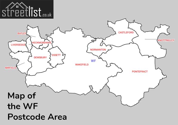
Map of the WF Wakefield Postcode Area
Explore the postcode area by using our interactive map.
Quick Facts about the WF Postcode
| Width from East to West | 23.82 mi |
| Height from North to South | 13.09 mi |
| Area of WF | 191.50 mi² |
| Maximum Width | 23.88 mi |
| Perimeter of Postcode Area | 103.58 mi |
| Number of Postcode Districts | 18 |
| Number of Postcode Sectors | 75 |
| Number of Post Towns | 11 |
| Number of Postcodes | 14,498 |
The WF postcode area represents a group of 17 postal districts in the Wakefield area of the United Kingdom. The area code stands for the letters w and f in WakeField. The area has a population of 512,657 and covers an area of 495,996 hectares. Fun fact: 0.79% of the population of Great Britain lives in this area.
The postcode area falls within the following counties: West Yorkshire (98.94%), North Yorkshire (1.04%), South Yorkshire (0.02%).
Post Towns and Postcode Districts
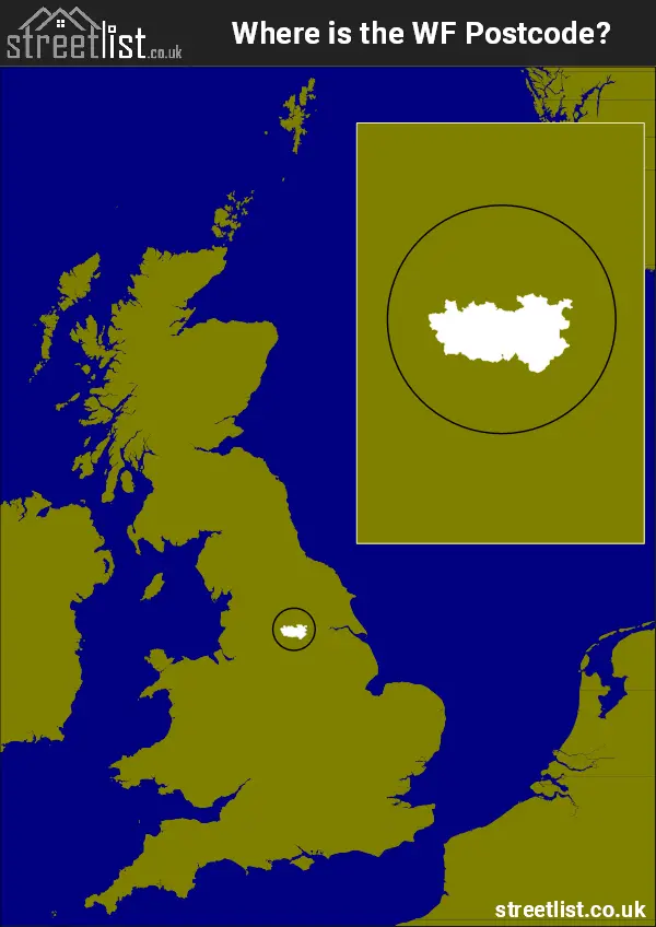
Where is the WF Postcode Area?
The WF Wakefield Postcode is in the Yorkshire and the Humber Region of England.. The postal area borders the following neighbouring postal areas: HD - Huddersfield, BD - Bradford, YO - York, S - Sheffield, DN - Doncaster and LS - Leeds, and is located inland.

How built up is the Postcode Area?
I've calculated the total area covered by building footprints within the postcode area.
By analyzing this against the total area, I've determined the percentage of the area that's developed, this will give you an idea of how urban or rural the postcode region is.
The higher the percentage the more urban the area is. For example the least urban district is WF4 and the most urban is WF13.
| Postcode District | Total Area (m²) | Footprint Area (m²) | Built Percentage % |
|---|---|---|---|
| WF4 | 91,950,215 | 2,333,599 | 2.54% |
| WF11 | 44,630,013 | 1,246,648 | 2.79% |
| WF8 | 61,043,122 | 1,708,383 | 2.80% |
| WF7 | 26,153,394 | 1,158,529 | 4.43% |
| WF9 | 45,685,512 | 2,334,738 | 5.11% |
| WF3 | 30,464,608 | 1,705,676 | 5.60% |
| WF14 | 16,604,881 | 1,035,197 | 6.23% |
| WF12 | 24,516,925 | 1,691,547 | 6.90% |
| WF2 | 36,456,128 | 2,809,715 | 7.71% |
| WF10 | 32,703,262 | 2,561,988 | 7.83% |
| WF15 | 10,843,560 | 865,411 | 7.98% |
| WF5 | 12,801,726 | 1,163,326 | 9.09% |
| WF1 | 20,494,218 | 1,864,418 | 9.10% |
| WF6 | 15,273,319 | 1,533,060 | 10.04% |
| WF17 | 16,105,767 | 1,997,785 | 12.40% |
| WF16 | 3,598,586 | 578,916 | 16.09% |
| WF13 | 6,671,077 | 1,135,362 | 17.02% |
| Total | 495,996,313 (m²) | 27,724,298 (m²) | 5.59% |

A map showing the boundary of WF in relation to other areas
There are 18 towns within the Wakefield postcode area.
| Unit | Area² |
|---|---|
| Hectares | 495,996² |
| Miles | 1,915² |
| Feet | 53,388,513,444² |
| Kilometres | 4,960² |
Postal Delivery Offices Serving the Postcode Area
- Batley Delivery Office
- Caldergrove Scale Payment Delivery Office
- Calderway Delivery Office
- Crigglestone Scale Payment Delivery Office
- Crofton Scale Payment Delivery Office
- East Ardsley Scale Payment Delivery Office
- Flockton Scale Payment Delivery Office
- Heckmondwike Delivery Office
- Hemsworth Scale Payment Delivery Office
- Middlestown Scale Payment Delivery Office
- Notton Scale Payment Delivery Office
- Ossett Delivery Office
- Pontefract Delivery Office
- Robin Hood Scale Payment Delivery Office
- Ryhill Scale Payment Delivery Office
- Sharlston Common Scale Payment Delivery Office
- South Elmsall Scale Payment Delivery Office
- South Kirkby Scale Payment Delivery Office
- Stanley Scale Payment Delivery Office
- Upton (wf) Scale Payment Delivery Office
- Wakefield Delivery Office
- Whitwood Delivery Office
Tourist Attractions within the Area
We found 11 visitor attractions within the Wakefield postcode area
| Bagshaw Museum |
|---|
| Museums & Art Galleries |
| Museum and / or Art Gallery |
| View Bagshaw Museum on Google Maps |
| Dewsbury Minster |
| Places of Worship |
| Place of Worship (still in use) |
| View Dewsbury Minster on Google Maps |
| Yorkshire Sculpture Park |
| Museums & Art Galleries |
| Museum and / or Art Gallery |
| View Yorkshire Sculpture Park on Google Maps |
| Wakefield Museum |
| Museums & Art Galleries |
| Museum and / or Art Gallery |
| View Wakefield Museum on Google Maps |
| The Hepworth Wakefield |
| Museums & Art Galleries |
| Museum and / or Art Gallery |
| View The Hepworth Wakefield on Google Maps |
| Walton Colliery Nature Park |
| Wildlife |
| Nature Reserve / Wetlands / Wildlife Trips |
| View Walton Colliery Nature Park on Google Maps |
| Anglers Country Park |
| Country Parks |
| Country Park |
| View Anglers Country Park on Google Maps |
| Nostell Priory & Parkland |
| Historic Properties |
| Historic House / House and Garden / Palace |
| View Nostell Priory & Parkland on Google Maps |
| Castleford Museum |
| Museums & Art Galleries |
| Museum and / or Art Gallery |
| View Castleford Museum on Google Maps |
| Pontefract Museum |
| Museums & Art Galleries |
| Museum and / or Art Gallery |
| View Pontefract Museum on Google Maps |
| Treasurer's House (Wess) |
| Historic Properties |
| Historic House / House and Garden / Palace |
| View Treasurer's House (Wess) on Google Maps |
Councils with Postcodes the Area
Towns and Villages within the Area
- Ackton - village
- Ackworth Moor Top - village
- Allerton Bywater - village
- Badsworth - village
- Batley - town
- Birkin - village
- Bottom Boat - village
- Briestfield - village
- Brotherton - village
- Burton Salmon - village
- Byram - village
- Calder Grove - village
- Carlton - village
- Castleford - town
- Chapelthorpe - village
- Cleckheaton - town
- Coxley - village
- Cridling Stubbs - village
- Crigglestone - village
- Crofton - village
- Darrington - village
- Dewsbury - town
- Durkar - village
- East Ardsley - village
- East Hardwick - village
- Fairburn - village
- Featherstone - town
- Ferrybridge - village
- Fitzwilliam - village
- Flockton - village
- Flockton Green - village
- Gomersal - village
- Grange Moor - village
- Hall Green - village
- Havercroft - village
- Heath - village
- Heckmondwike - town
- Hemsworth - town
- High Ackworth - village
- Holmfield - village
- Horbury - town
- Kellingley - village
- Kinsley - village
- Kirk Smeaton - village
- Kirkhamgate - village
- Kirkthorpe - village
- Knottingley - town
- Ledston - village
- Leeds - city
- Little Smeaton - village
- Liversedge - town
- Lofthouse - village
- Low Ackworth - village
- Middlestown - village
- Midgley - village
- Mirfield - town
- Morley - town
- Netherton - village
- Newmillerdam - village
- Normanton - town
- North Elmsall - village
- Notton - village
- Old Snydale - village
- Ossett - town
- Overton - village
- Pontefract - town
- Robin Hood - village
- Rothwell - town
- Ryhill - village
- Sharlston - village
- South Elmsall - town
- South Kirkby - town
- Streethouse - village
- Thorpe Audlin - village
- Thorpe on the Hill - village
- Upton - village
- Wakefield - city
- Walton - village
- Warmfield - village
- Wentbridge - village
- West Ardsley - village
- West Bretton - village
- Whitley Lower - village
- Woodend - village
- Woolley - village
- Wragby - village