This section of the site is all about the YO Postcode area, also known as the York Postal Area. Explore links to the next level to learn more about specific postcode districts such as YO1.
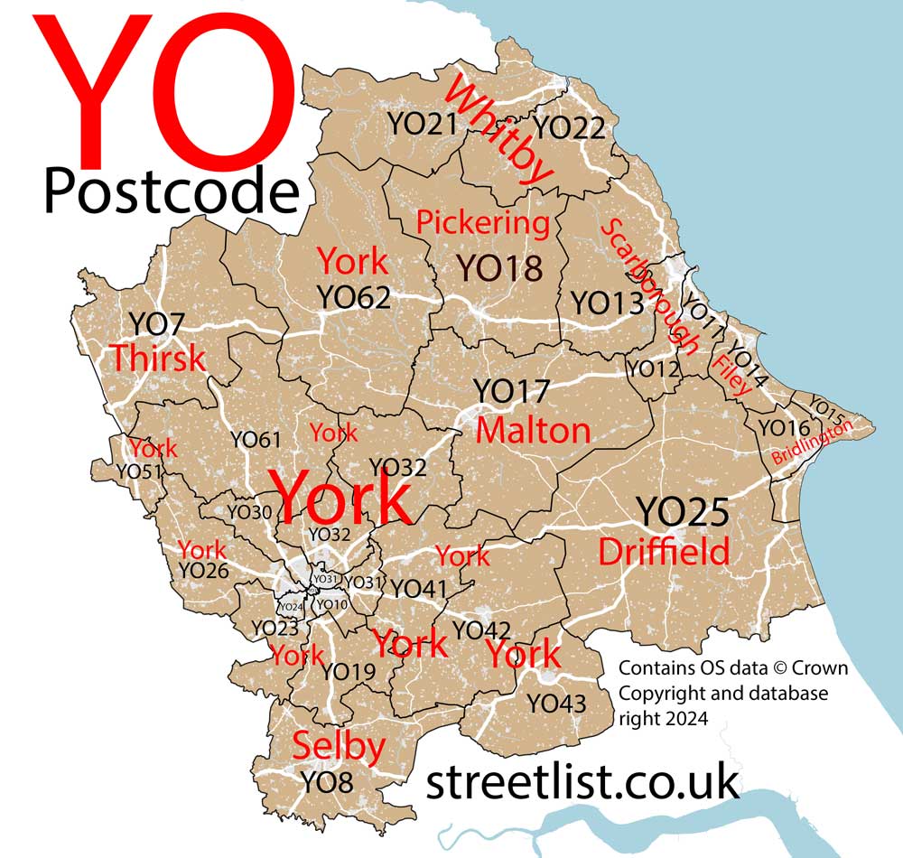
The YO postcode area represents a group of postal districts in the York area of the United Kingdom. The area code YO stands for the letters y and o in YOrk. YO has a population of 562,439 and covers an area of 4,907,688 hectares. Fun fact: 0.87% of the population of Great Britain lives in this area.
The postcode area falls within the following counties: North Yorkshire (79.05%), East Riding of Yorkshire (20.95%).
Post Towns and Postcode Districts for the YO Postcode
-
YO1 North YorkshireYO10 North YorkshireYO19 North YorkshireYO23 North YorkshireYO24 North YorkshireYO26 North YorkshireYO30 North YorkshireYO31 North YorkshireYO32 North YorkshireYO41 East Riding of Yorkshire (70%), North Yorkshire (29%)YO42 East Riding of YorkshireYO43 East Riding of YorkshireYO51 North YorkshireYO60 North YorkshireYO61 North YorkshireYO62 North YorkshireYO90 YO91
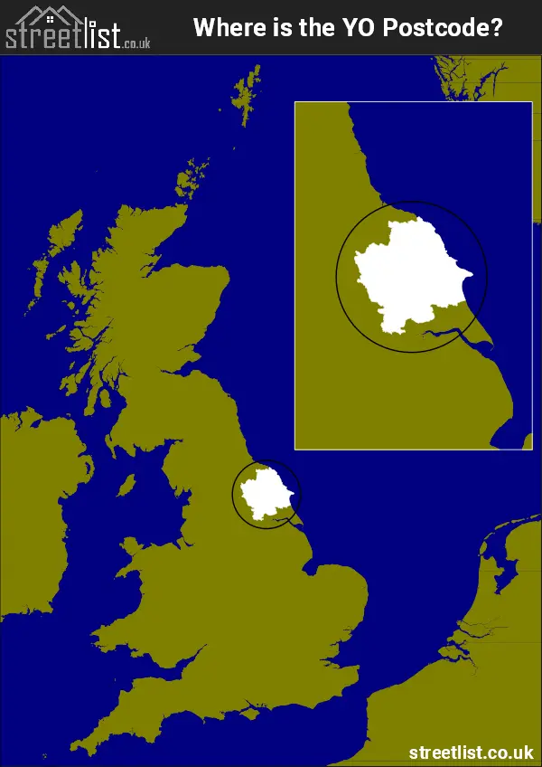
Where is the YO Postcode Area?
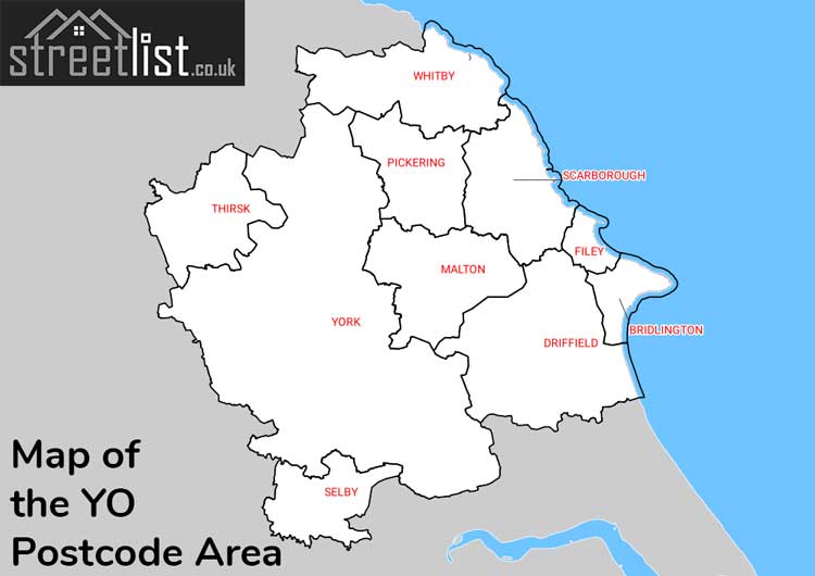
The YO York Postcode is in the Yorkshire and the Humber Region of England. The postal area borders the following neighbouring postal areas: WF - Wakefield, TS - Teeside, DL - Darlington, DN - Doncaster, HG - Harrogate, LS - Leeds and HU - Hull, It also borders The North Sea,
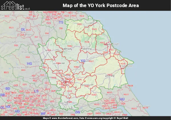
Map of the YO York Postcode Area
Explore the YO York postcode area by using our interactive map.
Postcode Districts within the YO York Postcode Area
There are 29 postcode districts within the York postcode area
A map showing the boundary of in relation to other areas
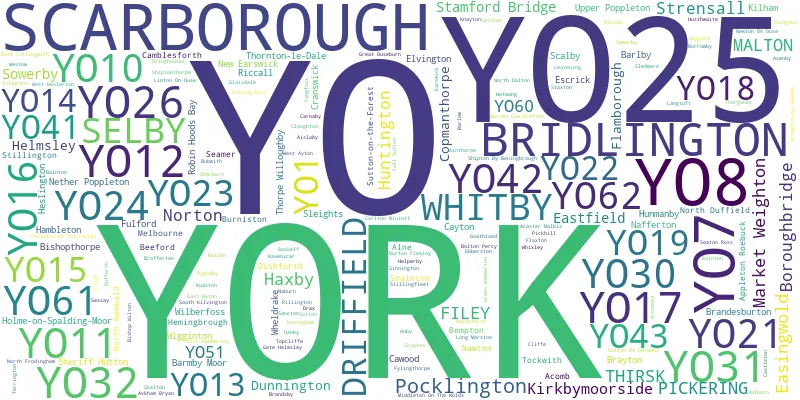
There are 17 towns within the York postcode area.
| Unit | Area² |
|---|---|
| Hectares | 4,907,688² |
| Miles | 18,949² |
| Feet | 528,258,628,632² |
| Kilometres | 49,077² |
Postal Delivery Offices serving the YO York Postcode Area
- Bempton Scale Payment Delivery Office
- Birch Park Delivery Office
- Boroughbridge Scale Payment Delivery Office
- Bridlington Delivery Office
- Castleton Scale Payment Delivery Office
- Danby Scale Payment Delivery Office
- Driffield Delivery Office
- Easingwold Scale Payment Delivery Office
- Elvington Scale Payment Delivery Office
- Filey Delivery Office
- Flamborough Scale Payment Delivery Office
- Great Ouseburn Scale Payment Delivery Office
- Green Hammerton Scale Payment Delivery Office
- Helmsley Scale Payment Delivery Office
- Helperby Scale Payment Delivery Office
- Kildale Scale Payment Delivery Office
- Kirby Misperton Scale Payment Delivery Office
- Kirkbymoorside Scale Payment Delivery Office
- Leavening Scale Payment Delivery Office
- Malton Delivery Office
- Market Weighton Scale Payment Delivery Office
- Marston Scale Payment Delivery Office
- Pickering Delivery Office
- Pocklington Delivery Office
- Scarborough Delivery Office
- Selby Delivery Office
- Sherburn (malton) Scale Payment Delivery Office
- Sheriff Hutton Scale Payment Delivery Office
- Stamford Bridge Scale Payment Delivery Office
- Thirsk Delivery Office
- West Heslerton Scale Payment Delivery Office
- Whitby Delivery Office
- Wilberfoss Scale Payment Delivery Office
- York Central Delivery Office
- York West Delivery Office
Councils with Postcodes in YO
Towns and Villages within the YO York Postcode Area
- Acaster Malbis - village
- Ainthorpe - village
- Airmyn - village
- Aislaby - village
- Aldborough - village
- Aldwark - village
- Allerston - village
- Allerthorpe - village
- Alne - village
- Amotherby - village
- Ampleforth - village
- Appleton Roebuck - village
- Appleton-le-Street - village
- Asenby - village
- Askham Bryan - village
- Askham Richard - village
- Atwick - village
- Bagby - village
- Bainton - village
- Baldersby - village
- Baldersby St James - otherSettlement
- Barlby - village
- Barlow - village
- Barmby Moor - village
- Barmston - village
- Barton-le-Street - village
- Barton-le-Willows - village
- Beadlam - village
- Beeford - village
- Bempton - village
- Beswick - village
- Bewholme - village
- Bielby - village
- Bilton in Ainsty - village
- Birdsall - village
- Bishop Wilton - village
- Bishopthorpe - village
- Bolton - village
- Bolton Percy - village
- Boroughbridge - town
- Borrowby - village
- Boynton - village
- Brafferton - village
- Brandesburton - village
- Brandsby - village
- Brawby - village
- Brayton - village
- Bridlington - town
- Briggswath - village
- Brompton-by-Sawdon - village
- Broughton - village
- Bubwith - village
- Buckton - village
- Bugthorpe - village
- Bulmer - village
- Burn - village
- Burniston - village
- Burton Agnes - village
- Burton Fleming - village
- Burythorpe - village
- Camblesforth - village
- Carlton Husthwaite - village
- Carlton Miniott - village
- Carnaby - village
- Carr End - village
- Castleton - village
- Cattal - village
- Cawood - village
- Chapel Haddlesey - village
- Claxton - village
- Cliffe - village
- Cloughton - village
- Colton Lane End - otherSettlement
- Commondale - village
- Copmanthorpe - village
- Coxwold - village
- Crayke - village
- Cundall - village
- Dalton - otherSettlement
- Danby - village
- Deighton - village
- Dishforth - village
- Drax - village
- Driffield - town
- Dringhoe - otherSettlement
- Duggleby - village
- Dunnington - village
- Earswick - village
- Easingwold - town
- East Ayton - village
- East Cottingwith - village
- East Heslerton - village
- Ebberston - village
- Egton - village
- Egton Bridge - village
- Ellerton - village
- Elvington - village
- Escrick - village
- Eskdaleside - village
- Everingham - village
- Fangfoss - village
- Felixkirk - village
- Filey - town
- Flamborough - village
- Flaxton - village
- Flixton - village
- Foggathorpe - village
- Foston - village
- Foston on the Wolds - village
- Foxholes - village
- Fridaythorpe - village
- Full Sutton - village
- Fylingthorpe - village
- Ganton - village
- Garton-on-the-Wolds - village
- Gate Helmsley - village
- Gateforth - village
- Gillamoor - village
- Gilling East - village
- Glaisdale - village
- Goathland - village
- Goodmanham - village
- Grafton - village
- Great Edstone - village
- Great Habton - village
- Great Kelk - otherSettlement
- Great Ouseburn - village
- Green Hammerton - village
- Grimston - otherSettlement
- Grindale - village
- Gristhorpe - village
- Grosmont - village
- Hackness - village
- Haisthorpe - village
- Hambleton - village
- Harome - village
- Harpham - village
- Hawsker - village
- Haxby - town
- Hayton - village
- Helmsley - town
- Helperby - village
- Helperthorpe - village
- Hemingbrough - village
- Heslington - village
- Hessay - village
- High Catton - village
- High Hutton - village
- Hirst Courtney - village
- Holme upon Spalding Moor - village
- Holtby - village
- Hotham - village
- Hovingham - village
- Huby - village
- Huggate - village
- Hunmanby - village
- Huntington - Settlement
- Husthwaite - village
- Hutton Buscel - village
- Hutton Cranswick - village
- Hutton Sessay - village
- Hutton-le-Hole - village
- Irton - village
- Keldholme - village
- Kelfield - village
- Kelleythorpe - village
- Kexby - village
- Kilburn - village
- Kilham - village
- Kilnwick - village
- Kirby Grindalythe - village
- Kirby Hill - village
- Kirby Misperton - village
- Kirby Wiske - village
- Kirk Hammerton - village
- Kirkburn - village
- Kirkby Mills - village
- Kirkbymoorside - town
- Knapton - village
- Knayton - village
- Langdale End - otherSettlement
- Langthorpe - village
- Langtoft - village
- Lastingham - village
- Lealholm - village
- Leavening - village
- Lebberston - village
- Linton-on-Ouse - village
- Lissett - village
- Little Driffield - village
- Little Ouseburn - village
- Lockington - village
- Lockton - village
- Londesborough - village
- Long Marston - village
- Low Catton - village
- Low Hutton - village
- Lowthorpe - otherSettlement
- Lund - village
- Lythe - village
- Malton - town
- Market Weighton - town
- Marton - village
- Marton - village
- Maunby - village
- Melbourne - village
- Middlethorpe - otherSettlement
- Middleton - village
- Middleton-on-the-Wolds - village
- Minskip - village
- Moor End - village
- Murton - village
- Muston - village
- Myton-on-Swale - village
- Naburn - village
- Nafferton - village
- Nawton - village
- Nether Poppleton - village
- New Earswick - village
- Newholm - village
- Newton upon Derwent - village
- Newton-on-Ouse - village
- Newton-on-Rawcliffe - village
- North Dalton - village
- North Duffield - village
- North Frodingham - village
- North Newbald - village
- Norton-on-Derwent - town
- Nun Monkton - village
- Nunburnholme - village
- Nunnington - village
- Osbaldwick - village
- Osgodby - village
- Oswaldkirk - village
- Pickering - town
- Pickhill - village
- Pocklington - town
- Primrose Valley - village
- Rainton - village
- Raskelf - village
- Ravenscar - village
- Reighton - village
- Reighton Sands - otherSettlement
- Riccall - village
- Rillington - village
- Robin Hood's Bay - village
- Roecliffe - village
- Rosedale Abbey - village
- Ross Moor - otherSettlement
- Rudston - village
- Rufforth - village
- Ruswarp - village
- Sancton - village
- Sand Hole - otherSettlement
- Sand Hutton - village
- Sandhutton - village
- Sandsend - village
- Sawdon - village
- Scackleton - village
- Scagglethorpe - village
- Scalby - village
- Scarborough - town
- Seamer - village
- Seaton Ross - village
- Selby - town
- Sessay - village
- Settrington - village
- Sewerby - village
- Sherburn - village
- Sheriff Hutton - village
- Shipton - village
- Shiptonthorpe - village
- Sinderby - village
- Sinnington - village
- Skelton - village
- Skerne - village
- Skipsea - village
- Skipton-on-Swale - village
- Skipwith - village
- Skirpenbeck - village
- Sledmere - village
- Sleights - village
- Slingsby - village
- Snainton - village
- Sneaton - village
- South Duffield - village
- South Kilvington - village
- South Newbald - village
- Sowerby - village
- Speeton - village
- Sproxton - village
- Stainsacre - village
- Stamford Bridge - village
- Staxton - village
- Stillingfleet - village
- Stillington - village
- Stockton on the Forest - village
- Strensall - village
- Sutton upon Derwent - village
- Sutton-on-the-Forest - village
- Sutton-under-Whitestonecliffe - village
- Swinton - village
- Temple Hirst - village
- Terrington - village
- Thirlby - village
- Thirsk - town
- Tholthorpe - village
- Thorganby - village
- Thornton-le-Clay - village
- Thornton-le-Dale - village
- Thornton-le-Street - village
- Thorpe Willoughby - village
- Thwing - village
- Tibthorpe - village
- Tockwith - village
- Tollerton - village
- Topcliffe - village
- Towthorpe - village
- Ugthorpe - village
- Ulrome - village
- Upper Poppleton - village
- Wansford - village
- Warter - village
- Warthill - village
- Wass - village
- Water End - otherSettlement
- Watton - village
- Weaverthorpe - village
- Welburn - village
- West Ayton - village
- West Haddlesey - village
- West Heslerton - village
- West Lutton - village
- Westerdale - village
- Westow - village
- Wetwang - village
- Wharram le Street - village
- Wheldrake - village
- Whitby - town
- Whitwell-on-the-Hill - village
- Wigginton - village
- Wilberfoss - village
- Willerby - village
- Wilsthorpe - village
- Wilton - village
- Wistow - village
- Wold Newton - village
- Wombleton - village
- Wrelton - village
- Wressle - village
- Wykeham - village
- Yapham - village
- Yedingham - village
- York - city