This section of the site is all about the DL Postcode area, also known as the Darlington Postal Area. Explore links to the next level to learn more about specific postcode districts such as DL1.
The DL postcode area represents a group of postal districts in the Darlington area of the United Kingdom. The area code DL stands for the letters d and l in DarLington. DL has a population of 360,975 and covers an area of 3,427,343 hectares. Fun fact: 0.56% of the population of Great Britain lives in this area.
The postcode area falls within the following counties: Durham (68.51%), North Yorkshire (31.48%), Cumbria (0.01%).
Post Towns and Postcode Districts for the DL Postcode
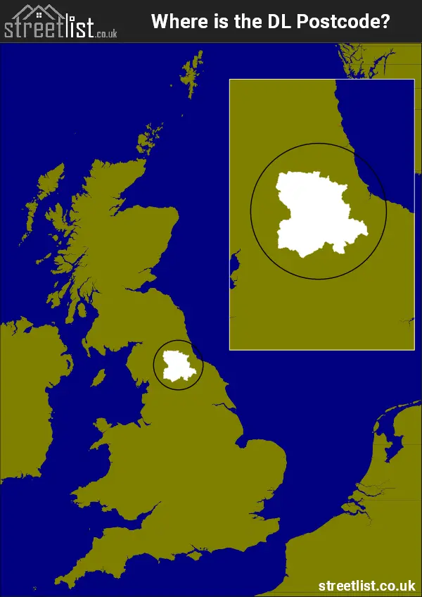
Where is the DL Postcode Area?
The DL Darlington Postcode has it's North in The North East of England and it's South is in Yorkshire and the Humber Region. The postal area borders the following neighbouring postal areas: LA - Lancaster, CA - Carlisle, NE - Newcastle upon Tyne, BD - Bradford, YO - York, TS - Teeside, DH - Durham and HG - Harrogate, and is located inland.
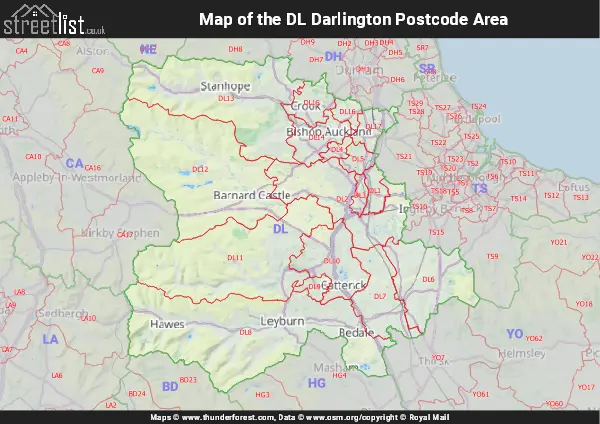
Map of the DL Darlington Postcode Area
Explore the DL Darlington postcode area by using our interactive map.
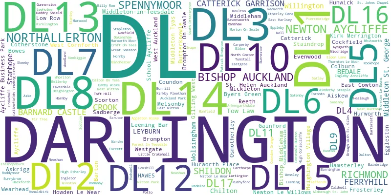
Postcode Districts within the DL Darlington Postcode Area
There are 17 postcode districts within the Darlington postcode area
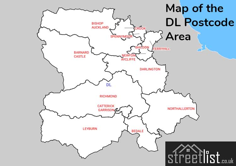
A map showing the boundary of in relation to other areas
There are 17 towns within the Darlington postcode area.
| Unit | Area² |
|---|---|
| Hectares | 3,427,343² |
| Miles | 13,233² |
| Feet | 368,915,773,177² |
| Kilometres | 34,273² |
Postal Delivery Offices serving the DL Darlington Postcode Area
- Barnard Castle Delivery Office
- Darlington Delivery Office
- Hawes Scale Payment Delivery Office
- Leyburn Delivery Office
- Newton Aycliffe Delivery Office
- Northallerton Delivery Office
- Richmond (dl) Delivery Office
- Spennymoor Delivery Office
- Wear Valley Delivery Office
Councils with Postcodes in DL
Towns and Villages within the DL Darlington Postcode Area
- Ainderby Steeple - village
- Aiskew - village
- Aldbrough St John - village
- Appleton Wiske - village
- Askrigg - village
- Aysgarth - village
- Bainbridge - village
- Barnard Castle - town
- Barningham - village
- Barton - village
- Beaumont Hill - village
- Bedale - town
- Bellerby - village
- Billy Row - village
- Binchester - village
- Bishop Auckland - town
- Bishop Middleham - village
- Boldron - village
- Bowes - village
- Brompton - village
- Brompton-on-Swale - village
- Burneston - village
- Burrill - village
- Burtersett - village
- Butterknowle - village
- Byers Green - village
- Caldwell - village
- Carlton - village
- Carperby - village
- Carthorpe - village
- Castle Bolton - village
- Catterick - village
- Catterick Garrison - Settlement
- Chilton - village
- Cleasby - village
- Close House - village
- Coatham Mundeville - village
- Cockfield - village
- Constable Burton - village
- Copley - village
- Coronation - village
- Cotherstone - village
- Coundon - village
- Coundon Grange - village
- Coundongate - village
- Crawleyside - village
- Croft-on-Tees - village
- Crook - town
- Dalton - village
- Dalton-on-Tees - village
- Danby Wiske - village
- Darlington - town
- East Cowton - village
- East Harlsey - village
- East Hedleyhope - village
- East Layton - village
- East Witton - village
- Eggleston - village
- Eldon - village
- Eldon Lane - village
- Eppleby - village
- Escomb - village
- Evenwood - village
- Exelby - village
- Feetham - village
- Ferryhill - town
- Finghall - village
- Fir Tree - village
- Forcett - village
- Forest-in-Teesdale - otherSettlement
- Frosterley - village
- Gainford - village
- Gayle - village
- Gayles - village
- Gilling West - village
- Great Crakehall - village
- Great Fencote - village
- Great Langton - village
- Great Smeaton - village
- Grinton - village
- Gunnerside - village
- Hackforth - village
- Hamsterley - village
- Harmby - village
- Hawes - village
- Healaugh - village
- Heighington - village
- Helmington Row - village
- High Coniscliffe - village
- High Etherley - village
- High Lands - village
- Hornby - village
- Hornby - village
- Howden-le-Wear - village
- Hudswell - village
- Hunton - village
- Hunwick - village
- Hurworth-on-Tees - village
- Hutton Magna - village
- Ingleby Arncliffe - village
- Ingleton - village
- Ireshopeburn - village
- Kearton - otherSettlement
- Kiplin - otherSettlement
- Kirk Merrington - village
- Kirkby Fleetham - village
- Kirklington - village
- Langthwaite - village
- Lartington - village
- Leeholme - village
- Leeming - village
- Leeming Bar - village
- Lendings - village
- Leyburn - town
- Little Crakehall - village
- Londonderry - village
- Longnewton - village
- Low Etherley - village
- Low Row - village
- Manfield - village
- Marske - village
- Melsonby - village
- Merrybent - village
- Mickleton - village
- Middleham - town
- Middleton St George - village
- Middleton Tyas - village
- Middleton-in-Teesdale - village
- Middridge - village
- Morton-on-Swale - village
- Moulton - village
- Muker - village
- Neasham - village
- Newby Wiske - village
- Newfield - village
- Newsham - village
- Newton Aycliffe - town
- Newton-le-Willows - village
- North Bitchburn - village
- North Close - village
- North Cowton - village
- Northallerton - town
- Nosterfield - village
- Oakenshaw - village
- Osmotherley - village
- Ovington - village
- Patrick Brompton - village
- Piercebridge - village
- Potto - village
- Preston-under-Scar - village
- Ramshaw - village
- Ravensworth - village
- Redmire - village
- Redworth - village
- Reeth - village
- Richmond - town
- Roddymoor - village
- Romaldkirk - village
- Romanby - village
- Rookhope - village
- Rushyford - village
- Sadberge - village
- Satley - village
- School Aycliffe - village
- Scorton - village
- Scotch Corner - otherSettlement
- Scruton - village
- Sedbusk - village
- Shildon - town
- Skeeby - village
- Snape - village
- South Otterington - village
- Spennithorne - village
- Spennymoor - town
- St John's Chapel - village
- Staindrop - village
- Stainton - village
- Stainton Grove - village
- Stanhope - town
- Stapleton - village
- Startforth - village
- Summerhouse - village
- Sunniside - village
- Sunnybrow - village
- Swainby - village
- Thoralby - village
- Thornborough - village
- Thornley - village
- Thornton Rust - village
- Thornton-le-Beans - village
- Thornton-le-Moor - village
- Thrintoft - village
- Toft Hill - village
- Toronto - village
- Tow Law - town
- Tunstall - village
- Wearhead - village
- Welbury - village
- Well - village
- Wensley - village
- West Auckland - village
- West Burton - village
- West Rounton - village
- West Witton - village
- Westgate - village
- Whashton - village
- Whorlton - village
- Willington - town
- Winston - village
- Witton Park - village
- Witton-le-Wear - village
- Wolsingham - town
- Woodland - village
- Woodside - village
- Worton - village
- Yafforth - village