This section of the site is all about the NE Postcode area, also known as the Newcastle upon Tyne Postal Area. Explore links to the next level to learn more about specific postcode districts such as NE1.
The NE postcode area represents a group of postal districts in the Newcastle upon Tyne area of the United Kingdom. The area code NE stands for the letters n and e in NEwcastle upon Tyne. NE has a population of 1,162,698 and covers an area of 4,799,616 hectares. Fun fact: 1.79% of the population of Great Britain lives in this area.
The postcode area falls within the following counties: Tyne & Wear (66.03%), Northumberland (33.36%), Durham (0.61%).
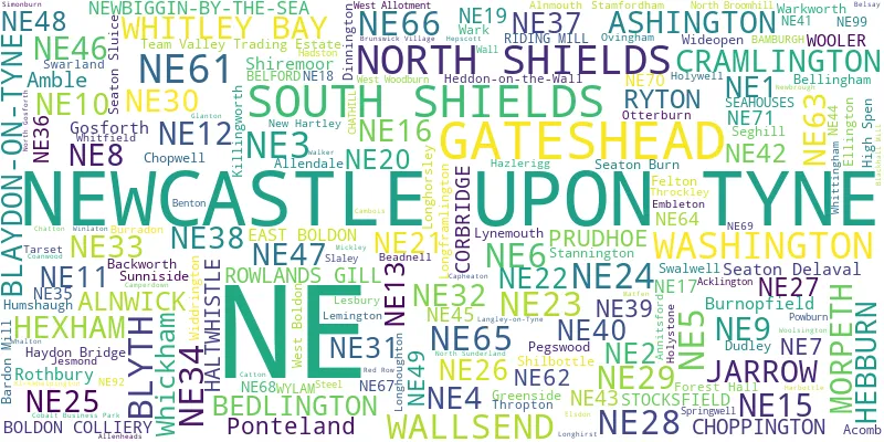
Post Towns and Postcode Districts for the NE Postcode
-
NE1 Tyne & WearNE2 Tyne & WearNE3 Tyne & WearNE4 Tyne & WearNE5 Tyne & WearNE6 Tyne & WearNE7 Tyne & WearNE12 Tyne & WearNE13 Northumberland (2%), Tyne & Wear (97%)NE15 Northumberland (8%), Tyne & Wear (91%)NE16 Durham (18%), Tyne & Wear (81%)NE17 Durham (26%), Northumberland (6%), Tyne & Wear (67%)NE18 NorthumberlandNE19 NorthumberlandNE20 Northumberland (98%), Tyne & Wear (1%)NE27 Tyne & WearNE85 NE88 NE98 NE99
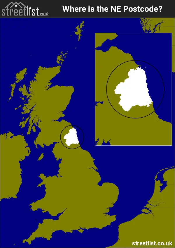
Where is the NE Postcode Area?
The NE Newcastle upon Tyne Postcode is in the North East of England. The postal area borders the following neighbouring postal areas: TD - Teviotdale, SR - Sunderland, CA - Carlisle, DL - Darlington and DH - Durham, It also borders The North Sea,
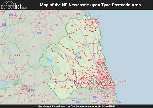
Map of the NE Newcastle upon Tyne Postcode Area
Explore the NE Newcastle upon Tyne postcode area by using our interactive map.
Postcode Districts within the NE Newcastle upon Tyne Postcode Area
There are 59 postcode districts within the Newcastle upon Tyne postcode area
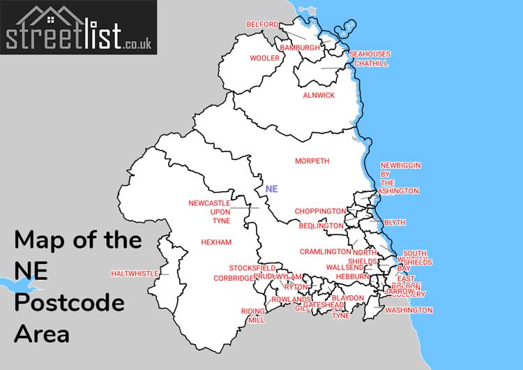
A map showing the boundary of in relation to other areas
There are 26 towns within the Newcastle upon Tyne postcode area.
| Unit | Area² |
|---|---|
| Hectares | 4,799,616² |
| Miles | 18,531² |
| Feet | 516,625,866,624² |
| Kilometres | 47,996² |
Postal Delivery Offices serving the NE Newcastle upon Tyne Postcode Area
- Alnwick Delivery Office
- Ashington Delivery Office
- Blaydon-on-tyne Delivery Office
- Blyth Delivery Office
- Cramlington Delivery Office
- Forest Hall Delivery Office
- Gateshead Delivery Office
- Gosforth Delivery Office
- Haltwhistle Scale Payment Delivery Office
- Heaton Delivery Office
- Hexham Delivery Office
- Jarrow Delivery Office
- Morpeth Delivery Office
- Newcastle Upon Tyne City Delivery Office
- North Tyneside Delivery Office
- Ponteland Delivery Office
- Prudhoe Delivery Office
- South Shields Delivery Office
- Valley Delivery Office
- Washington Delivery Office
- West Delivery Office (ne)
Councils with Postcodes in NE
Towns and Villages within the NE Newcastle upon Tyne Postcode Area
- Acklington - village
- Acomb - village
- Allendale Town - village
- Allenheads - village
- Alnmouth - village
- Alnwick - town
- Amble - town
- Ashington - town
- Backworth - village
- Bamburgh - village
- Bardon Mill - village
- Barlow - village
- Barrasford - village
- Beadnell - village
- Bedlington - town
- Belford - village
- Bellingham - village
- Belsay - village
- Birtley - Settlement
- Blackhall Mill - village
- Blaydon - town
- Blyth - town
- Bomarsund - village
- Boulmer - village
- Broomhill - village
- Brunswick Village - village
- Burnopfield - village
- Butteryhaugh - village
- Byermoor - village
- Byrness - village
- Callerton - village
- Cambo - village
- Cambois - village
- Catton - village
- Chatton - village
- Chollerford - village
- Choppington - village
- Chopwell - village
- Christon Bank - village
- Clara Vale - village
- Cleadon - village
- Corbridge - town
- Cramlington - town
- Craster - village
- Crawcrook - village
- Cresswell - village
- Crookgate Bank - village
- Dinnington - village
- Dipton - village
- Dirt Pot - village
- Doddington - village
- Dudley - village
- Dunstan - village
- Earsdon - village
- East Boldon - village
- East Hartford - village
- East Sleekburn - village
- Eglingham - village
- Ellingham - village
- Ellington - village
- Elsdon - village
- Embleton - village
- Eshott - village
- Fair Moor - village
- Falstone - village
- Felton - village
- Follingsby - otherSettlement
- Fourstones - village
- Gateshead - town
- Glanton - village
- Great Whittington - village
- Greenside - village
- Guide Post - village
- Gunnerton - village
- Hadston - village
- Haltwhistle - town
- Hamsterley - village
- Hamsterley Mill - village
- Harbottle - village
- Haydon Bridge - village
- Hazlerigg - village
- Hebburn - town
- Heddon-on-the-Wall - village
- Hedley on the Hill - village
- Hepscott - village
- Hexham - town
- High Hauxley - village
- High Newton-by-the-Sea - village
- High Spen - village
- Highfield - village
- Hipsburn - village
- Hobson - village
- Hooker Gate - village
- Horsley - village
- Humshaugh - village
- Jarrow - town
- Juniper - village
- Kibblesworth - village
- Kielder - village
- Killingworth - Urban Area
- Kirkwhelpington - village
- Lesbury - village
- Linton - village
- Longbenton - town
- Longframlington - village
- Longhirst - village
- Longhorsley - village
- Longhoughton - village
- Low Newton-by-the-Sea - village
- Low Westwood - village
- Lucker - village
- Lynemouth - village
- Marley Hill - village
- Matfen - village
- Medburn - village
- Melkridge - village
- Mickley Square - village
- Milfield - village
- Mitford - village
- Morpeth - town
- Murton - village
- Nedderton - village
- Netherton - village
- Netherwitton - village
- New Hartley - village
- New Ridley - village
- New York - village
- Newbrough - village
- Newburn - village
- Newcastle upon Tyne - city
- Newton Hall - village
- Newton on the Moor - village
- North Blyth - village
- North End - village
- North Sunderland - village
- Oakwood - village
- Ogle - village
- Otterburn - village
- Ouston - village
- Ovingham - village
- Ovington - village
- Pegswood - village
- Ponteland - town
- Powburn - village
- Prestwick - village
- Prudhoe - town
- Red Row - village
- Redburn - village
- Rennington - village
- Riding Mill - village
- Ridsdale - village
- Rochester - village
- Rothbury - town
- Rowlands Gill - village
- Ryton - town
- Ryton Woodside - village
- Scots' Gap - village
- Seahouses - village
- Seaton - otherSettlement
- Seaton Burn - village
- Seaton Sluice - village
- Seghill - village
- Shilbottle - village
- Shiremoor - village
- Slaley - village
- South Broomhill - village
- South Charlton - village
- South Shields - town
- Springwell - village
- Stakeford - village
- Stamfordham - village
- Stannington - village
- Stobswood - village
- Stocksfield - village
- Street Gate - village
- Sunderland - city
- Sunniside - village
- Swarland - village
- Throckley - village
- Thropton - village
- Togston - village
- Tranwell Woods - otherSettlement
- Tynemouth - town
- Ulgham - village
- Victoria Garesfield - village
- Walbottle - village
- Wall - village
- Wallsend - town
- Wark - village
- Warkworth - village
- Washington - town
- West Boldon - village
- West Mickley - village
- West Sleekburn - village
- West Thirston - village
- West Woodburn - village
- Whalton - village
- Whickham - town
- Whitley Bay - town
- Whittingham - village
- Widdrington - village
- Wideopen - village
- Winlaton Mill - village
- Wooler - town
- Woolsington - village
- Wylam - village