
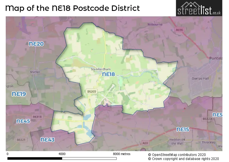
Map of the Postcode District
Explore the postcode district by using our interactive map.
Circles represent recorded crime; the larger the circle, the higher the crime rates.
Your support helps keep this site running!
If you enjoy using this website, consider buying me a coffee to help cover hosting costs.
The postcode district located in the NE Newcastle upon Tyne postal area , NE18 has a population of 944 residents according to the 2021 England and Wales Census.
The area of the district is 16.43 square miles (42.55 square kilometers or 10,513.46 acres).
Where is the NE18 District?
To give you an idea where the district is located we have created the following table showing nearby towns.
Nearest Towns to NE18
| Town | Distance (miles) | Direction |
|---|---|---|
| Ponteland | 5.07 | E |
| Prudhoe | 5.27 | S |
| Ryton | 6.15 | SE |
| Corbridge | 7.26 | SW |
| Blaydon | 7.99 | SE |
| Whickham | 9.98 | SE |
| Hexham | 10.19 | WSW |
| Newcastle upon Tyne | 11.13 | ESE |
| Morpeth | 11.52 | NE |
| Cramlington | 11.77 | ENE |
| Gateshead | 11.83 | ESE |
| Longbenton | 12.19 | E |
| Bedlington | 12.60 | ENE |
| Consett | 12.78 | S |
| Annfield Plain | 12.99 | SSE |
| Stanley | 13.38 | SSE |
| Wallsend | 13.77 | ESE |
| Hebburn | 14.75 | ESE |
| Jarrow | 15.58 | ESE |
| Ashington | 15.68 | NE |
The post town for this district is NEWCASTLE UPON TYNE.
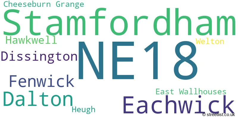
Postcode Information for District NE18 (Total Geographical Postcodes: 70)
| Location | Post Town | Sector | Number of Postcodes |
|---|---|---|---|
| Stamfordham | NEWCASTLE UPON TYNE | NE18 0 | 36 |
| Eachwick | NEWCASTLE UPON TYNE | NE18 0 | 12 |
| Dalton | NEWCASTLE UPON TYNE | NE18 0 | 8 |
| Fenwick | NEWCASTLE UPON TYNE | NE18 0 | 5 |
| Dissington | NEWCASTLE UPON TYNE | NE18 0 | 3 |
| Hawkwell | NEWCASTLE UPON TYNE | NE18 0 | 2 |
| Heugh | NEWCASTLE UPON TYNE | NE18 0 | 1 |
| Cheeseburn Grange | NEWCASTLE UPON TYNE | NE18 0 | 1 |
| Welton | NEWCASTLE UPON TYNE | NE18 0 | 1 |
| East Wallhouses | NEWCASTLE UPON TYNE | NE18 0 | 1 |
In the NE18 postcode district, the primary settlement is Stamfordham, located in the county of Northumberland in England. Other significant settlements in this district include Dalton, Dissington, Eachwick, Fenwick, Hawkwell, and Welton. The main post town for this postcode district is Newcastle upon Tyne.
When it comes to local government, postal geography often disregards political borders. However, this district intersects the following councils: the district mostly encompasses the Northumberland area with a total of 70 postal codes.
The largest settlement in the NE18 postal code is Stamfordham followed by Dalton, and Eachwick.
The NE18 Postcode shares a border with NE43 (STOCKSFIELD, Mickley, Newton), NE15 (NEWCASTLE UPON TYNE, Heddon-on-the-Wall, Lemington) and NE20 (Ponteland, Belsay, Matfen).
Postcode Sectors


Schools in the Sector
Stamfordham Primary School
Phase: Primary
Address: Stamfordham , Newcastle-upon-Tyne
Postcode: NE18 0NA
Headteacher: Miss Lynsey Briddock (Headteacher)
Ofsted Rating: Outstanding
Stations in the Sector
No stations found in this postcode district.
Accessable Motorway Junctions
A194(M) J1
Average Driving Time from within the district: 24.62
Average Driving Distance: 19.06
Number of Postcodes that can access the Motorway Junction: 70
A194(M) J2
Average Driving Time from within the district: 25.19
Average Driving Distance: 18.57
Number of Postcodes that can access the Motorway Junction: 70
A1(M) J64
Average Driving Time from within the district: 25.35
Average Driving Distance: 19.39
Number of Postcodes that can access the Motorway Junction: 70
Weather Forecast for Albemarle
| Time Period | Icon | Description | Temperature | Rain Probability | Wind |
|---|---|---|---|---|---|
| 12:00 to 15:00 | Sunny day | 12.0°C (feels like 10.0°C) | 0.00% | W 9 mph | |
| 15:00 to 18:00 | Sunny day | 12.0°C (feels like 10.0°C) | 0.00% | WSW 7 mph | |
| 18:00 to 21:00 | Clear night | 8.0°C (feels like 7.0°C) | 0.00% | SW 4 mph | |
| 21:00 to 00:00 | Cloudy | 7.0°C (feels like 6.0°C) | 3.00% | S 2 mph |
| Time Period | Icon | Description | Temperature | Rain Probability | Wind |
|---|---|---|---|---|---|
| 00:00 to 03:00 | Cloudy | 7.0°C (feels like 5.0°C) | 3.00% | S 4 mph | |
| 03:00 to 06:00 | Cloudy | 9.0°C (feels like 7.0°C) | 5.00% | SSW 4 mph | |
| 06:00 to 09:00 | Cloudy | 9.0°C (feels like 8.0°C) | 4.00% | SSW 4 mph | |
| 09:00 to 12:00 | Cloudy | 11.0°C (feels like 9.0°C) | 4.00% | SW 4 mph | |
| 12:00 to 15:00 | Partly cloudy (day) | 14.0°C (feels like 11.0°C) | 0.00% | SW 7 mph | |
| 15:00 to 18:00 | Cloudy | 13.0°C (feels like 11.0°C) | 3.00% | SSW 7 mph | |
| 18:00 to 21:00 | Cloudy | 11.0°C (feels like 9.0°C) | 4.00% | S 4 mph | |
| 21:00 to 00:00 | Cloudy | 9.0°C (feels like 7.0°C) | 4.00% | S 4 mph |
| Time Period | Icon | Description | Temperature | Rain Probability | Wind |
|---|---|---|---|---|---|
| 00:00 to 03:00 | Cloudy | 10.0°C (feels like 8.0°C) | 4.00% | S 4 mph | |
| 03:00 to 06:00 | Cloudy | 10.0°C (feels like 7.0°C) | 4.00% | S 7 mph | |
| 06:00 to 09:00 | Cloudy | 9.0°C (feels like 6.0°C) | 4.00% | S 7 mph | |
| 09:00 to 12:00 | Partly cloudy (day) | 10.0°C (feels like 7.0°C) | 1.00% | S 7 mph | |
| 12:00 to 15:00 | Partly cloudy (day) | 12.0°C (feels like 9.0°C) | 1.00% | S 9 mph | |
| 15:00 to 18:00 | Partly cloudy (day) | 13.0°C (feels like 10.0°C) | 1.00% | S 7 mph | |
| 18:00 to 21:00 | Partly cloudy (night) | 11.0°C (feels like 9.0°C) | 3.00% | SSE 7 mph | |
| 21:00 to 00:00 | Cloudy | 11.0°C (feels like 9.0°C) | 7.00% | SSE 4 mph |
| Time Period | Icon | Description | Temperature | Rain Probability | Wind |
|---|---|---|---|---|---|
| 00:00 to 03:00 | Overcast | 11.0°C (feels like 9.0°C) | 18.00% | S 4 mph | |
| 03:00 to 06:00 | Cloudy | 11.0°C (feels like 9.0°C) | 18.00% | S 4 mph | |
| 06:00 to 09:00 | Cloudy | 10.0°C (feels like 8.0°C) | 17.00% | S 4 mph | |
| 09:00 to 12:00 | Cloudy | 11.0°C (feels like 9.0°C) | 16.00% | SSW 7 mph | |
| 12:00 to 15:00 | Partly cloudy (day) | 12.0°C (feels like 10.0°C) | 16.00% | SSW 7 mph | |
| 15:00 to 18:00 | Light rain shower (day) | 11.0°C (feels like 9.0°C) | 31.00% | SSW 7 mph | |
| 18:00 to 21:00 | Partly cloudy (night) | 9.0°C (feels like 7.0°C) | 6.00% | S 7 mph | |
| 21:00 to 00:00 | Partly cloudy (night) | 8.0°C (feels like 6.0°C) | 6.00% | SSW 4 mph |
| Time Period | Icon | Description | Temperature | Rain Probability | Wind |
|---|---|---|---|---|---|
| 00:00 to 03:00 | Partly cloudy (night) | 8.0°C (feels like 5.0°C) | 5.00% | SSW 4 mph | |
| 03:00 to 06:00 | Cloudy | 8.0°C (feels like 5.0°C) | 7.00% | SSW 4 mph | |
| 06:00 to 09:00 | Partly cloudy (night) | 8.0°C (feels like 6.0°C) | 4.00% | SW 7 mph | |
| 09:00 to 12:00 | Cloudy | 10.0°C (feels like 7.0°C) | 10.00% | SW 7 mph | |
| 12:00 to 15:00 | Cloudy | 11.0°C (feels like 9.0°C) | 14.00% | WSW 9 mph | |
| 15:00 to 18:00 | Cloudy | 11.0°C (feels like 8.0°C) | 9.00% | WSW 7 mph | |
| 18:00 to 21:00 | Partly cloudy (night) | 9.0°C (feels like 6.0°C) | 3.00% | WSW 7 mph | |
| 21:00 to 00:00 | Clear night | 8.0°C (feels like 5.0°C) | 4.00% | WSW 7 mph |
| Postal Sector | Delivery Office |
|---|---|
| NE18 0 | Ponteland Delivery Office |
| N | E | 1 | 8 | - | X | X | X |
| N | E | 1 | 8 | Space | Numeric | Letter | Letter |
Street List for the NE18 District
Current Monthly Rental Prices
| # Bedrooms | Min Price | Max Price | Avg Price |
|---|
Current House Prices
| # Bedrooms | Min Price | Max Price | Avg Price |
|---|---|---|---|
| 3 | £275,000 | £275,000 | £275,000 |
| 4 | £595,000 | £955,000 | £700,000 |
| 5 | £400,000 | £1,450,000 | £900,000 |
| 6 | £1,495,000 | £1,495,000 | £1,495,000 |
Estate Agents
| Logo | Name | Brand Name | Address | Contact Number |
|---|---|---|---|---|
 | Corbridge | Finest Properties | Crossways, Market Place, Corbridge NE45 5AW | 01434 409033 |
 | Hexham | Galbraith | Hexham Business Park, Burn Lane, Hexham, NE46 3RU | 01434 405346 |
 | Gosforth | Sanderson Young | 95 High Street, Gosforth, Newcastle Upon Tyne, NE3 4AA | 0191 625 1008 |
 | Corbridge | Anton Estates | 19 Middle Street, Corbridge, NE45 5AT | 01434 405340 |
 | Newcastle upon Tyne | Goodfellows | 11 West Road Ponteland Newcastle upon Tyne Northumberland NE20 9SU | 01661 525170 |
Yearly House Price Averages for the District
| Type of Property | 2018 Average | 2018 Sales | 2017 Average | 2017 Sales | 2016 Average | 2016 Sales | 2015 Average | 2015 Sales |
|---|---|---|---|---|---|---|---|---|
| Detached | £491,000 | 6 | £265,625 | 4 | £413,000 | 5 | £566,421 | 7 |
| Semi-Detached | £290,000 | 1 | £262,625 | 4 | £325,000 | 1 | £502,500 | 4 |
| Terraced | £215,417 | 6 | £373,750 | 2 | £221,488 | 4 | £169,500 | 4 |
| Flats | £95,500 | 1 | £0 | 0 | £0 | 0 | £100,000 | 1 |