The NE29 postcode district is a postal district located in the NE Newcastle upon Tyne postcode area with a population of 35,744 residents according to the 2021 England and Wales Census.
The area of the NE29 postcode district is 4.15 square miles which is 10.75 square kilometres or 2,656.60 acres.
Currently, the NE29 district has about 938 postcode units spread across 5 geographic postcode sectors.
Given that each sector allows for 400 unique postcode combinations, the district has a capacity of 2,000 postcodes. With 938 postcodes already in use, this leaves 1062 units available.
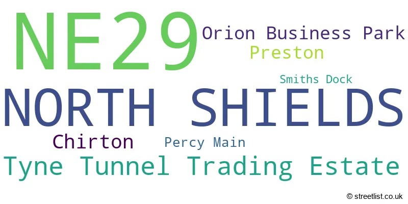
The NE29 postal code covers the settlement of NORTH SHIELDS.
The postcode area has a boundary with The North Sea.
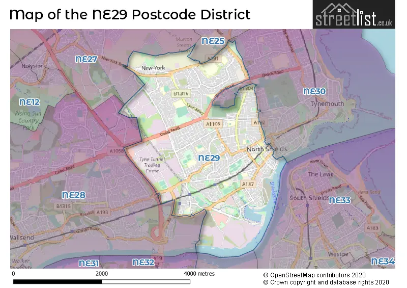
The NE29 Postcode shares a border with NE28 (WALLSEND), NE30 (NORTH SHIELDS, Tynemouth, Cullercoats), NE25 (WHITLEY BAY, Seaton Delaval, New Hartley) and NE27 (Shiremoor, Backworth, West Allotment).
In the NE29 postcode district, the primary settlement is North Shields located in Tyne & Wear, the county of Tyne & Wear is in England. Other significant settlements include Chirton, Percy Main, Smiths Dock, Orion Business Park, and Tyne Tunnel Trading Estate. The most significant post town is North Shields.
For the district NE29, we have data on 6 postcode sectors. Here's a breakdown: The sector NE29 0, covers North Shields in Tyne & Wear. The sector NE29 1 is non-geographic. It's often designated for PO Boxes, large organisations, or special services. The sector NE29 6, covers North Shields in Tyne & Wear. The sector NE29 7, covers North Shields in Tyne & Wear. The sector NE29 8, covers North Shields in Tyne & Wear. The sector NE29 9, covers North Shields in Tyne & Wear.

Map of the NE29 Postcode District
Explore the NE29 postcode district by using our free interactive map.
When it comes to local government, postal geography often disregards political borders. However, for a breakdown in the NE29 District: the district mostly encompasses the North Tyneside District (B) area with a total of 952 postcodes.
Recent House Sales in NE29
| Date | Price | Address |
|---|---|---|
| 20/10/2023 | £130,000 | Newington Drive, North Shields, NE29 9JA |
| 16/10/2023 | £150,000 | Gardner Park, North Shields, NE29 0EA |
| 06/10/2023 | £75,000 | Brookland Terrace, North Shields, NE29 8EP |
| 29/09/2023 | £359,950 | Abbots Way, North Shields, NE29 8LY |
| 22/09/2023 | £390,000 | Smiths Dock, North Shields, NE29 6TA |
| 21/09/2023 | £85,000 | Hopper Street, North Shields, NE29 0DD |
| 21/09/2023 | £215,000 | Billy Mill Avenue, North Shields, NE29 0QS |
| 18/09/2023 | £145,000 | Queen Alexandra Road, North Shields, NE29 9AS |
| 18/09/2023 | £290,000 | Belvedere, North Shields, NE29 9BX |
| 15/09/2023 | £206,000 | Ashford Close, North Shields, NE29 9HY |
Weather Forecast for NE29
Press Button to Show Forecast for Chirton
| Time Period | Icon | Description | Temperature | Rain Probability | Wind |
|---|---|---|---|---|---|
| 06:00 to 09:00 | Cloudy | 4.0°C (feels like 1.0°C) | 4.00% | NNW 7 mph | |
| 09:00 to 12:00 | Cloudy | 6.0°C (feels like 4.0°C) | 35.00% | NNE 7 mph | |
| 12:00 to 15:00 | Cloudy | 7.0°C (feels like 5.0°C) | 11.00% | ENE 7 mph | |
| 15:00 to 18:00 | Cloudy | 8.0°C (feels like 6.0°C) | 10.00% | E 7 mph | |
| 18:00 to 21:00 | Sunny day | 7.0°C (feels like 5.0°C) | 4.00% | E 7 mph | |
| 21:00 to 00:00 | Partly cloudy (night) | 4.0°C (feels like 2.0°C) | 2.00% | SE 4 mph |
Press Button to Show Forecast for Chirton
| Time Period | Icon | Description | Temperature | Rain Probability | Wind |
|---|---|---|---|---|---|
| 00:00 to 03:00 | Partly cloudy (night) | 3.0°C (feels like 1.0°C) | 2.00% | SSE 4 mph | |
| 03:00 to 06:00 | Partly cloudy (night) | 2.0°C (feels like 0.0°C) | 3.00% | SSW 4 mph | |
| 06:00 to 09:00 | Partly cloudy (day) | 3.0°C (feels like 1.0°C) | 5.00% | SSE 4 mph | |
| 09:00 to 12:00 | Cloudy | 7.0°C (feels like 5.0°C) | 9.00% | ESE 7 mph | |
| 12:00 to 15:00 | Partly cloudy (day) | 9.0°C (feels like 6.0°C) | 8.00% | ESE 9 mph | |
| 15:00 to 18:00 | Sunny day | 9.0°C (feels like 6.0°C) | 6.00% | E 11 mph | |
| 18:00 to 21:00 | Partly cloudy (day) | 8.0°C (feels like 5.0°C) | 6.00% | E 11 mph | |
| 21:00 to 00:00 | Cloudy | 6.0°C (feels like 3.0°C) | 10.00% | E 9 mph |
Press Button to Show Forecast for Chirton
| Time Period | Icon | Description | Temperature | Rain Probability | Wind |
|---|---|---|---|---|---|
| 00:00 to 03:00 | Cloudy | 5.0°C (feels like 3.0°C) | 14.00% | ENE 9 mph | |
| 03:00 to 06:00 | Cloudy | 6.0°C (feels like 3.0°C) | 16.00% | NE 9 mph | |
| 06:00 to 09:00 | Overcast | 7.0°C (feels like 3.0°C) | 17.00% | NE 13 mph | |
| 09:00 to 12:00 | Light rain | 7.0°C (feels like 4.0°C) | 50.00% | NE 13 mph | |
| 12:00 to 15:00 | Light rain | 8.0°C (feels like 4.0°C) | 50.00% | NNE 13 mph | |
| 15:00 to 18:00 | Light rain | 8.0°C (feels like 5.0°C) | 50.00% | NNE 13 mph | |
| 18:00 to 21:00 | Partly cloudy (day) | 8.0°C (feels like 7.0°C) | 14.00% | N 9 mph | |
| 21:00 to 00:00 | Partly cloudy (night) | 6.0°C (feels like 3.0°C) | 11.00% | ESE 9 mph |
Where is the NE29 Postcode District?
The data shows that the NE29 postcode district is located in North Shields. North Shields is surrounded by several nearby towns, including Wallsend to the west, South Shields to the southeast, Whitley Bay to the north, Jarrow to the south, Hebburn to the southwest, and Cramlington to the northwest. Additionally, the distance between North Shields and London is approximately 248.46 miles.
The district is within the post town of NORTH SHIELDS.
The sector has postcodes within the nation of England.
The NE29 Postcode District is in the Tyneside region of Northumberland and Tyne and Wear within the North East (England).
| Postcode Sector | Delivery Office |
|---|---|
| NE29 0 | North Tyneside Delivery Office |
| NE29 6 | North Tyneside Delivery Office |
| NE29 7 | North Tyneside Delivery Office |
| NE29 8 | North Tyneside Delivery Office |
| NE29 9 | North Tyneside Delivery Office |
| N | E | 2 | 9 | - | X | X | X |
| N | E | 2 | 9 | Space | Numeric | Letter | Letter |
Tourist Attractions within the Postcode Area
We found 1 visitor attractions within the NE29 postcode area
| Stephenson Railway Museum |
|---|
| Museums & Art Galleries |
| Museum and / or Art Gallery |
| View Stephenson Railway Museum on Google Maps |
Current Monthly Rental Prices
| # Bedrooms | Min Price | Max Price | Avg Price |
|---|---|---|---|
| £70 | £150 | £130 | |
| 1 | £495 | £495 | £495 |
| 2 | £500 | £700 | £593 |
| 3 | £600 | £700 | £650 |
| 4 | £900 | £900 | £900 |
Current House Prices
| # Bedrooms | Min Price | Max Price | Avg Price |
|---|---|---|---|
| £25,000 | £400,000 | £233,250 | |
| 1 | £40,000 | £172,500 | £99,978 |
| 2 | £37,000 | £400,000 | £133,681 |
| 3 | £69,950 | £395,000 | £217,444 |
| 4 | £79,000 | £450,000 | £309,673 |
| 5 | £200,000 | £645,000 | £423,158 |
| 6 | £499,950 | £499,950 | £499,950 |
Estate Agents who Operate in the NE29 District
| Logo | Name | Brand Name | Address | Contact Number | Total Properties |
|---|---|---|---|---|---|
 | North Shields | Pattinson Estate Agents | 3 Northumberland Place, North Shields, NE30 1QP | 0191 625 0109 | 25 |
 | Whitley Bay | Signature | Head Office, 32 Beach Avenue, Tyne and Wear, NE26 1EA | 0191 625 1042 | 24 |
 | Tynemouth | Jan Forster Estates | 10 Front Street, Tynemouth, North Shields, NE30 4RG | 0191 625 0806 | 19 |
 | Tynemouth | Brannen & Partners | 11 Front Street, Tynemouth, North Shields, NE30 4RG | 0191 625 0803 | 15 |
 | North Shields | Moving Homes Sales & Lettings Limited | 2a Hawkeys Lane North Shields NE29 0JF | 0191 625 0121 | 14 |
| Type of Property | 2018 Average | 2018 Sales | 2017 Average | 2017 Sales | 2016 Average | 2016 Sales | 2015 Average | 2015 Sales |
|---|---|---|---|---|---|---|---|---|
| Detached | £266,106 | 35 | £280,767 | 61 | £273,240 | 43 | £232,268 | 35 |
| Semi-Detached | £162,377 | 156 | £146,059 | 165 | £142,209 | 163 | £139,158 | 136 |
| Terraced | £170,583 | 200 | £141,437 | 198 | £138,510 | 171 | £145,722 | 196 |
| Flats | £99,319 | 184 | £84,019 | 161 | £82,858 | 170 | £80,450 | 190 |