The NE29 8 postcode sector is within the county of Tyne & Wear.
Did you know? According to the 2021 Census, the NE29 8 postcode sector is home to a bustling 9,030 residents!
Given that each sector allows for 400 unique postcode combinations. Letters C, I, K, M, O and V are not allowed in the last two letters of a postcode. With 197 postcodes already in use, this leaves 203 units available.
The NE29 8 postal code covers the settlement of NORTH SHIELDS.
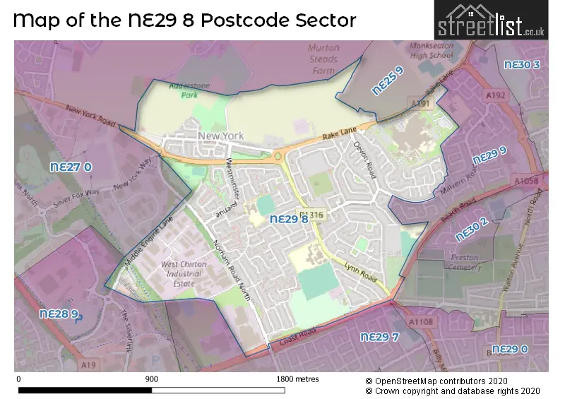
The NE29 8 Postcode shares a border with NE25 9 (WHITLEY BAY, South Wellfield, Earsdon), NE27 0 (Shiremoor, Backworth, West Allotment), NE29 0 (NORTH SHIELDS), NE29 7 (NORTH SHIELDS, Tyne Tunnel Trading Estate, Orion Business Park), NE29 9 (NORTH SHIELDS, Preston) and NE28 9 (WALLSEND).
The sector is within the post town of NORTH SHIELDS.
NE29 8 is a postcode sector within the NE29 postcode district which is within the NE Newcastle upon Tyne postcode area.
The Royal Mail delivery office for the NE29 8 postal sector is the North Tyneside Delivery Office.
The area of the NE29 8 postcode sector is 1.11 square miles which is 2.86 square kilometres or 707.77 square acres.

Map of the NE29 8 Postcode Sector
Explore the NE29 8 postcode sector by using our free interactive map.
| N | E | 2 | 9 | - | 8 | X | X |
| N | E | 2 | 9 | Space | 8 | Letter | Letter |
Official List of Streets
NORTH SHIELDS (110 Streets)
Unofficial Streets or Alternative Spellings
NORTH SHIELDS
BEACH ROAD BILLY MILL AVENUE BOULSWORTH ROAD CAYNHAM CLOSE KELSO DRIVE MALVERN ROAD NORHAM ROAD ALDER ROAD COAST ROAD CYCLEWAY CORONATION TERRACE LARCH COURT OAK ROAD REGENT TERRACE WESTMINSTER AVENUEMurton Village
MURTON LANENew York Industrial Park
NEW YORK WAYNORTH SHIELDS,
MIDDLE ENGINE LANEShiremoor
NEW YORK ROADNEWCASTLE UPON TYNE,
COAST ROADWeather Forecast for NE29 8
Press Button to Show Forecast for Chirton
| Time Period | Icon | Description | Temperature | Rain Probability | Wind |
|---|---|---|---|---|---|
| 12:00 to 15:00 | Overcast | 12.0°C (feels like 12.0°C) | 17.00% | SE 2 mph | |
| 15:00 to 18:00 | Overcast | 13.0°C (feels like 12.0°C) | 18.00% | SSW 9 mph | |
| 18:00 to 21:00 | Cloudy | 13.0°C (feels like 11.0°C) | 5.00% | SSW 9 mph | |
| 21:00 to 00:00 | Cloudy | 12.0°C (feels like 10.0°C) | 5.00% | SSW 7 mph |
Press Button to Show Forecast for Chirton
| Time Period | Icon | Description | Temperature | Rain Probability | Wind |
|---|---|---|---|---|---|
| 00:00 to 03:00 | Cloudy | 11.0°C (feels like 10.0°C) | 7.00% | SSW 7 mph | |
| 03:00 to 06:00 | Overcast | 10.0°C (feels like 9.0°C) | 10.00% | SSW 4 mph | |
| 06:00 to 09:00 | Cloudy | 11.0°C (feels like 10.0°C) | 8.00% | SSW 4 mph | |
| 09:00 to 12:00 | Cloudy | 13.0°C (feels like 12.0°C) | 9.00% | WSW 4 mph | |
| 12:00 to 15:00 | Overcast | 14.0°C (feels like 14.0°C) | 11.00% | WSW 4 mph | |
| 15:00 to 18:00 | Cloudy | 14.0°C (feels like 14.0°C) | 11.00% | SW 4 mph | |
| 18:00 to 21:00 | Overcast | 14.0°C (feels like 14.0°C) | 12.00% | S 4 mph | |
| 21:00 to 00:00 | Cloudy | 12.0°C (feels like 12.0°C) | 6.00% | SW 4 mph |
Press Button to Show Forecast for Chirton
| Time Period | Icon | Description | Temperature | Rain Probability | Wind |
|---|---|---|---|---|---|
| 00:00 to 03:00 | Cloudy | 11.0°C (feels like 11.0°C) | 5.00% | WSW 4 mph | |
| 03:00 to 06:00 | Cloudy | 10.0°C (feels like 10.0°C) | 5.00% | W 4 mph | |
| 06:00 to 09:00 | Cloudy | 11.0°C (feels like 10.0°C) | 7.00% | W 4 mph | |
| 09:00 to 12:00 | Partly cloudy (day) | 13.0°C (feels like 13.0°C) | 4.00% | WNW 4 mph | |
| 12:00 to 15:00 | Heavy rain shower (day) | 14.0°C (feels like 13.0°C) | 58.00% | ENE 7 mph | |
| 15:00 to 18:00 | Partly cloudy (day) | 14.0°C (feels like 13.0°C) | 5.00% | E 7 mph | |
| 18:00 to 21:00 | Light rain shower (day) | 12.0°C (feels like 11.0°C) | 38.00% | ENE 7 mph | |
| 21:00 to 00:00 | Cloudy | 10.0°C (feels like 9.0°C) | 7.00% | NE 4 mph |
Press Button to Show Forecast for Chirton
| Time Period | Icon | Description | Temperature | Rain Probability | Wind |
|---|---|---|---|---|---|
| 00:00 to 03:00 | Overcast | 10.0°C (feels like 9.0°C) | 10.00% | N 4 mph | |
| 03:00 to 06:00 | Mist | 9.0°C (feels like 8.0°C) | 19.00% | NNW 7 mph | |
| 06:00 to 09:00 | Overcast | 10.0°C (feels like 8.0°C) | 19.00% | N 7 mph | |
| 09:00 to 12:00 | Cloudy | 11.0°C (feels like 9.0°C) | 13.00% | N 9 mph | |
| 12:00 to 15:00 | Cloudy | 12.0°C (feels like 10.0°C) | 9.00% | NNE 9 mph | |
| 15:00 to 18:00 | Overcast | 12.0°C (feels like 10.0°C) | 9.00% | NE 9 mph | |
| 18:00 to 21:00 | Cloudy | 11.0°C (feels like 9.0°C) | 5.00% | NE 7 mph | |
| 21:00 to 00:00 | Overcast | 9.0°C (feels like 8.0°C) | 8.00% | NE 4 mph |
Press Button to Show Forecast for Chirton
| Time Period | Icon | Description | Temperature | Rain Probability | Wind |
|---|---|---|---|---|---|
| 00:00 to 03:00 | Overcast | 8.0°C (feels like 7.0°C) | 9.00% | ENE 4 mph | |
| 03:00 to 06:00 | Overcast | 8.0°C (feels like 7.0°C) | 9.00% | ENE 4 mph | |
| 06:00 to 09:00 | Overcast | 9.0°C (feels like 8.0°C) | 8.00% | S 4 mph | |
| 09:00 to 12:00 | Overcast | 11.0°C (feels like 10.0°C) | 7.00% | SE 7 mph | |
| 12:00 to 15:00 | Cloudy | 13.0°C (feels like 12.0°C) | 4.00% | SSE 7 mph | |
| 15:00 to 18:00 | Cloudy | 14.0°C (feels like 12.0°C) | 5.00% | SSE 9 mph | |
| 18:00 to 21:00 | Cloudy | 14.0°C (feels like 12.0°C) | 5.00% | S 9 mph | |
| 21:00 to 00:00 | Cloudy | 12.0°C (feels like 11.0°C) | 5.00% | SW 7 mph |
Schools and Places of Education Within the NE29 8 Postcode Sector
New York Primary School
Community school
Lanark Close, North Shields, Tyne and Wear, NE29 8DP
Head: Mrs Jill Shaw
Ofsted Rating: Outstanding
Inspection: 2013-05-16 (4006 days ago)
Website: Visit New York Primary School Website
Phone: 01918141788
Number of Pupils: 393
St Thomas More Catholic High School
Academy converter
Lynn Road, North Shields, Tyne and Wear, NE29 8LF
Head: Mr David Watson
Ofsted Rating: Good
Inspection: 2023-05-18 (352 days ago)
Website: Visit St Thomas More Catholic High School Website
Phone: 01912588340
Number of Pupils: 1609
House Prices in the NE29 8 Postcode Sector
| Type of Property | 2018 Average | 2018 Sales | 2017 Average | 2017 Sales | 2016 Average | 2016 Sales | 2015 Average | 2015 Sales |
|---|---|---|---|---|---|---|---|---|
| Detached | £277,908 | 19 | £285,659 | 38 | £264,816 | 25 | £221,000 | 11 |
| Semi-Detached | £143,244 | 58 | £143,850 | 61 | £137,429 | 62 | £134,382 | 41 |
| Terraced | £114,103 | 33 | £108,461 | 49 | £114,375 | 32 | £105,255 | 39 |
| Flats | £60,250 | 16 | £75,494 | 9 | £69,074 | 23 | £72,991 | 15 |
Important Postcodes NE29 8 in the Postcode Sector
NE29 8DP is the postcode for New York Primary School, Lanark Close
NE29 8DX is the postcode for Stephenson Railway Museum, Middle Engine Lane
NE29 8JB is the postcode for The Cedars, Morwick Road
NE29 8LF is the postcode for DINING HALL & KITCHEN, St. Thomas More RC VA High School, Lynn Road, St. Thomas More RC VA High School, Lynn Road, REAR SCHOOL BUILDING, St. Thomas More RC VA High School, Lynn Road, Main Building, St Thomas More RC Academy, 85 Lynn Road, LANGUAGE BLOCK, St. Thomas More RC VA High School, Lynn Road, Rear School Building, St Thomas More RC Academy, 85 Lynn Road, SPORTS HALL, St. Thomas More RC VA High School, Lynn Road, and MAIN BUILDING, St. Thomas More RC VA High School, Lynn Road
NE29 8NH is the postcode for Northumbria Healthcare NHS Trust, Rake Lane
NE29 8PE is the postcode for Whitehouse Primary School, Whitehouse Lane
NE29 8YY is the postcode for Royal Mail, North Tyneside Delivery Office, Cumberland Road
| The NE29 8 Sector is within these Local Authorities |
|
|---|---|
| The NE29 8 Sector is within these Counties |
|
| The NE29 8 Sector is within these Water Company Areas |
|
Tourist Attractions within the NE29 8 Postcode Area
We found 1 visitor attractions within the NE29 postcode area
| Stephenson Railway Museum |
|---|
| Museums & Art Galleries |
| Museum and / or Art Gallery |
| View Stephenson Railway Museum on Google Maps |