The NE65 postcode district is a postal district located in the NE Newcastle upon Tyne postcode area with a population of 21,558 residents according to the 2021 England and Wales Census.
The area of the NE65 postcode district is 221.90 square miles which is 574.71 square kilometres or 142,012.79 acres.
Currently, the NE65 district has about 1045 postcode units spread across 4 geographic postcode sectors.
Given that each sector allows for 400 unique postcode combinations, the district has a capacity of 1,600 postcodes. With 1045 postcodes already in use, this leaves 555 units available.
The largest settlement in the NE65 postal code is Amble followed by Rothbury, and Longframlington.
The postcode area has a boundary with The North Sea.
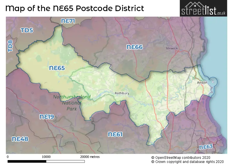
The NE65 Postcode shares a border with NE61 (MORPETH, Pegswood, Widdrington), NE66 (ALNWICK, Shilbottle, Longhoughton), NE71 (WOOLER, Milfield, Kirknewton), NE19 (Otterburn, Elsdon, Kirkwhelpington), TD5 (KELSO, Town Yetholm, Morebattle) and TD8 (JEDBURGH, Ancrum, Lanton).
The primary settlement in the NE65 postcode district is Morpeth in the county of Northumberland, England. Other significant settlements in this district include Amble, Warkworth, Rothbury, Longframlington, and Felton. The most significant post town in this district is also Morpeth.
For the district NE65, we have data on 4 postcode sectors. Here's a breakdown: The sector NE65 0, covers Amble and Warkworth in Northumberland. The sector NE65 7, covers Rothbury and Thropton in Northumberland. The sector NE65 8, covers Longframlington and Longhorsley in Northumberland. The sector NE65 9, covers Felton and Swarland and Hadston and Acklington and North Broomhill in Northumberland.

Map of the NE65 Postcode District
Explore the NE65 postcode district by using our free interactive map.
When it comes to local government, postal geography often disregards political borders. However, for a breakdown in the NE65 District: the district mostly encompasses the Northumberland area with a total of 1070 postcodes.
Recent House Sales in NE65
| Date | Price | Address |
|---|---|---|
| 20/10/2023 | £280,000 | Whitton View, Rothbury, Morpeth, NE65 7QN |
| 09/10/2023 | £465,000 | Riverside Park, Amble, Morpeth, NE65 0YR |
| 03/10/2023 | £190,000 | Gordon Street, Amble, Morpeth, NE65 0AT |
| 29/09/2023 | £150,500 | Beachcroft, Hadston, Morpeth, NE65 9RH |
| 22/09/2023 | £195,000 | The Maltings, Rothbury, Morpeth, NE65 7TG |
| 22/09/2023 | £485,000 | Cheviot Meadows, Acklington, Morpeth, NE65 9FL |
| 22/09/2023 | £210,000 | Wagtail Lane, Rothbury, Morpeth, NE65 7PH |
| 22/09/2023 | £260,000 | Ethels Close, Amble, Morpeth, NE65 0GD |
| 19/09/2023 | £125,000 | Elmfield Terrace, Hampeth, Morpeth, NE65 9LQ |
| 19/09/2023 | £310,000 | Chevington Green, Hadston, Morpeth, NE65 9AX |
Weather Forecast for NE65
Press Button to Show Forecast for Amble
| Time Period | Icon | Description | Temperature | Rain Probability | Wind |
|---|---|---|---|---|---|
| 21:00 to 00:00 | Clear night | 2.0°C (feels like 1.0°C) | 0.00% | S 2 mph |
Press Button to Show Forecast for Amble
| Time Period | Icon | Description | Temperature | Rain Probability | Wind |
|---|---|---|---|---|---|
| 00:00 to 03:00 | Clear night | 1.0°C (feels like -1.0°C) | 0.00% | W 4 mph | |
| 03:00 to 06:00 | Clear night | 1.0°C (feels like -1.0°C) | 0.00% | WNW 4 mph | |
| 06:00 to 09:00 | Sunny day | 4.0°C (feels like 2.0°C) | 0.00% | WNW 2 mph | |
| 09:00 to 12:00 | Partly cloudy (day) | 8.0°C (feels like 6.0°C) | 1.00% | ENE 7 mph | |
| 12:00 to 15:00 | Cloudy | 8.0°C (feels like 6.0°C) | 4.00% | E 9 mph | |
| 15:00 to 18:00 | Cloudy | 8.0°C (feels like 6.0°C) | 5.00% | E 9 mph | |
| 18:00 to 21:00 | Partly cloudy (day) | 7.0°C (feels like 5.0°C) | 2.00% | E 7 mph | |
| 21:00 to 00:00 | Partly cloudy (night) | 6.0°C (feels like 4.0°C) | 2.00% | E 7 mph |
Press Button to Show Forecast for Amble
| Time Period | Icon | Description | Temperature | Rain Probability | Wind |
|---|---|---|---|---|---|
| 00:00 to 03:00 | Cloudy | 6.0°C (feels like 4.0°C) | 4.00% | NE 7 mph | |
| 03:00 to 06:00 | Cloudy | 6.0°C (feels like 3.0°C) | 4.00% | NNE 11 mph | |
| 06:00 to 09:00 | Cloudy | 7.0°C (feels like 3.0°C) | 9.00% | N 13 mph | |
| 09:00 to 12:00 | Overcast | 7.0°C (feels like 3.0°C) | 14.00% | N 18 mph | |
| 12:00 to 15:00 | Heavy rain | 8.0°C (feels like 4.0°C) | 76.00% | NNW 16 mph | |
| 15:00 to 18:00 | Cloudy | 8.0°C (feels like 5.0°C) | 13.00% | NNW 13 mph | |
| 18:00 to 21:00 | Partly cloudy (day) | 9.0°C (feels like 7.0°C) | 6.00% | NW 9 mph | |
| 21:00 to 00:00 | Partly cloudy (night) | 7.0°C (feels like 4.0°C) | 2.00% | SW 7 mph |
Press Button to Show Forecast for Amble
| Time Period | Icon | Description | Temperature | Rain Probability | Wind |
|---|---|---|---|---|---|
| 00:00 to 03:00 | Clear night | 6.0°C (feels like 3.0°C) | 1.00% | SW 11 mph | |
| 03:00 to 06:00 | Clear night | 5.0°C (feels like 2.0°C) | 1.00% | SSW 9 mph | |
| 06:00 to 09:00 | Partly cloudy (day) | 6.0°C (feels like 3.0°C) | 2.00% | S 9 mph | |
| 09:00 to 12:00 | Partly cloudy (day) | 10.0°C (feels like 7.0°C) | 11.00% | S 13 mph | |
| 12:00 to 15:00 | Cloudy | 12.0°C (feels like 9.0°C) | 7.00% | S 16 mph | |
| 15:00 to 18:00 | Cloudy | 13.0°C (feels like 9.0°C) | 6.00% | SSE 16 mph | |
| 18:00 to 21:00 | Partly cloudy (day) | 11.0°C (feels like 8.0°C) | 3.00% | SSE 13 mph | |
| 21:00 to 00:00 | Partly cloudy (night) | 9.0°C (feels like 6.0°C) | 2.00% | SSE 13 mph |
Press Button to Show Forecast for Amble
| Time Period | Icon | Description | Temperature | Rain Probability | Wind |
|---|---|---|---|---|---|
| 00:00 to 03:00 | Clear night | 9.0°C (feels like 6.0°C) | 1.00% | SSE 13 mph | |
| 03:00 to 06:00 | Clear night | 8.0°C (feels like 5.0°C) | 1.00% | SSE 11 mph | |
| 06:00 to 09:00 | Partly cloudy (day) | 8.0°C (feels like 5.0°C) | 4.00% | SE 11 mph | |
| 09:00 to 12:00 | Light rain shower (day) | 10.0°C (feels like 8.0°C) | 29.00% | SE 11 mph | |
| 12:00 to 15:00 | Cloudy | 11.0°C (feels like 8.0°C) | 11.00% | E 13 mph | |
| 15:00 to 18:00 | Cloudy | 11.0°C (feels like 8.0°C) | 10.00% | E 13 mph | |
| 18:00 to 21:00 | Cloudy | 10.0°C (feels like 7.0°C) | 17.00% | E 11 mph | |
| 21:00 to 00:00 | Cloudy | 9.0°C (feels like 6.0°C) | 14.00% | E 9 mph |
Where is the NE65 Postcode District?
The data reveals that the NE65 postcode district is located in Morpeth. Morpeth is a district town situated in the North East region. Additionally, the nearby towns include Alnwick, Wooler, Choppington, and Mindrum. It is worth noting that the distance from Morpeth to London is approximately 274.77 miles.
The district is within the post town of MORPETH.
The sector has postcodes within the nation of England.
The NE65 Postcode District is in the Northumberland region of Northumberland and Tyne and Wear within the North East (England).
| Postcode Sector | Delivery Office |
|---|---|
| NE65 0 | Morpeth Delivery Office |
| NE65 7 | Morpeth Delivery Office |
| NE65 8 | Morpeth Delivery Office |
| NE65 9 | Morpeth Delivery Office |
| N | E | 6 | 5 | - | X | X | X |
| N | E | 6 | 5 | Space | Numeric | Letter | Letter |
Tourist Attractions within the Postcode Area
We found 2 visitor attractions within the NE65 postcode area
| Brinkburn Priory |
|---|
| Historic Properties |
| Historic Monument / Archaeological Site |
| View Brinkburn Priory on Google Maps |
| Warkworth Castle |
| Historic Properties |
| Castle / Fort |
| View Warkworth Castle on Google Maps |
Current Monthly Rental Prices
| # Bedrooms | Min Price | Max Price | Avg Price |
|---|---|---|---|
| 1 | £425 | £425 | £425 |
| 2 | £500 | £750 | £625 |
| 3 | £800 | £1,100 | £917 |
| 4 | £1,200 | £1,400 | £1,300 |
Current House Prices
| # Bedrooms | Min Price | Max Price | Avg Price |
|---|---|---|---|
| £125,000 | £35,000,000 | £5,139,286 | |
| 1 | £54,500 | £199,000 | £102,667 |
| 2 | £29,995 | £525,000 | £142,490 |
| 3 | £26,945 | £1,100,000 | £284,077 |
| 4 | £130,000 | £1,600,000 | £538,656 |
| 5 | £285,000 | £1,500,000 | £655,072 |
| 6 | £750,000 | £750,000 | £750,000 |
| 7 | £350,000 | £1,100,000 | £628,333 |
| 8 | £1,700,000 | £1,700,000 | £1,700,000 |
| 11 | £3,950,000 | £3,950,000 | £3,950,000 |
Estate Agents who Operate in the NE65 District
| Logo | Name | Brand Name | Address | Contact Number | Total Properties |
|---|---|---|---|---|---|
 | Alnwick | Pattinson Estate Agents | Bondgate Without, Alnwick, NE66 1PR | 01665 665745 | 27 |
 | Amble | Rook Matthews Sayer | 56 Queen Street, Amble, NE65 0BZ | 01665 713358 | 23 |
 | Thornton Cleveleys | Unique Estate Agency Ltd | 23 Victoria Road East, Thornton-Cleveleys FY5 5HT | 01253 835787 | 22 |
 | Northumberland | RE/MAX | Swarland | 07511 158771 | 17 |
 | North | Yopa | Meridian House Wheatfield Way Hinckley LE10 1YG | 0191 625 1007 | 15 |
- Acklington
- Amble
- Broomhill
- Burgham
- Byrness
- Eshott
- Felton
- Fenrother
- Hadston
- Hampeth
- Harbottle
- Hepple
- High Hauxley
- Longframlington
- Longhorsley
- Netherton
- Netherwitton
- Newton on the Moor
- Newtown
- North End
- Rothbury
- Shilbottle
- Snitter
- South Broomhill
- Swarland
- The Lee
- Thropton
- Togston
- Warkworth
- West Thirston
- Whitton
| Type of Property | 2018 Average | 2018 Sales | 2017 Average | 2017 Sales | 2016 Average | 2016 Sales | 2015 Average | 2015 Sales |
|---|---|---|---|---|---|---|---|---|
| Detached | £287,003 | 252 | £270,590 | 171 | £277,837 | 239 | £273,040 | 140 |
| Semi-Detached | £169,563 | 108 | £159,439 | 104 | £172,716 | 93 | £168,145 | 75 |
| Terraced | £158,012 | 130 | £159,041 | 148 | £162,296 | 157 | £147,727 | 138 |
| Flats | £221,464 | 14 | £214,053 | 19 | £228,550 | 20 | £142,785 | 12 |